Mori Atlas logo
Nature reserveTyre Coast Nature Reserve

Explore the mapped boundaries and regional landscape context of this Lebanese nature reserve.

Tyre Coast Nature Reserve: A Protected Landscape in Lebanon's Geographic Atlas

Delve into Tyre Coast Nature Reserve, a significant protected natural area within Lebanon. This page serves as a geographic anchor, detailing the reserve's mapped boundaries and its place within the country's diverse landscape context. Understand the natural terrain and protected land distribution that defines this important nature reserve for atlas-based exploration.

Coastal reserveRamsar siteSea turtle nesting siteMediterranean wetlandsMigratory bird habitatCoastal dunes

Tyre Coast Nature Reserve

Nature reserve

Park overview

Structured park overview, official facts, and landscape profile for Tyre Coast Nature Reserve

Tyre Coast Nature Reserve park facts, protected area profile, and essential visitor context

Review the core facts for Tyre Coast Nature Reserve, including designation, size, terrain, visitor scale, habitats, and operating context in one park-focused overview.

About Tyre Coast Nature Reserve

Tyre Coast Nature Reserve represents a significant achievement in Lebanese environmental protection, established in 1998 to preserve a stretch of coastline that combines remarkable natural diversity with profound historical significance. The reserve's location along the southeastern edge of ancient Tyre places it at the intersection of natural and cultural heritage, where the Phoenician civilization first developed sophisticated maritime trading networks. The three-zone management structure reflects a thoughtful approach to balancing competing demands: allowing public access to beaches and historic areas while maintaining strict protection for the most ecologically sensitive habitats. The Ras El Ain springs, with their continuous freshwater flow, create an unusual coastal wetland environment that supports species assemblages found nowhere else in Lebanon. This ecological distinctiveness, combined with the site's proximity to a major refugee settlement, demonstrates how nature reserves can function within complex human landscapes.

Quick facts and research context for Tyre Coast Nature Reserve

Tyre Coast Nature Reserve occupies approximately 380 hectares along Lebanon's southern Mediterranean coast, southeast of the ancient city of Tyre. The reserve is organized into three distinct management zones: a tourism zone encompassing public beaches and the historic port area, an agricultural and archaeological zone preserving traditional land use and cultural heritage, and a conservation zone protecting the ecologically sensitive Phoenician spring system at Ras El Ain. Designated as a Ramsar Site in April 1999, the reserve supports remarkable biodiversity including nesting populations of Loggerhead and Green sea turtles, diverse migratory bird species, and several mammal species including the Arabian spiny mouse.

Protection and recognition

Mapping the conservation boundaries and documented management framework of the coastal reserve

Tyre Coast Nature Reserve Protection Status and Protected Area Designation

Users can analyze the official protection status and documented conservation framework established for Tyre Coast Nature Reserve. Understanding the designated boundaries and mixed management classifications helps researchers track how coastal habitats fit into broader Mediterranean conservation networks.

Protection details

Protection scope
Mixed
Transboundary protection
No
Park context

Deeper park guide and search-rich context for Tyre Coast Nature Reserve

Tyre Coast Nature Reserve history, landscape, wildlife, and travel context

Explore Tyre Coast Nature Reserve through its history, landscape character, ecosystems, wildlife, conservation priorities, cultural context, and seasonal travel timing in a structured park guide built for atlas discovery and search intent.

Why Tyre Coast Nature Reserve stands out

The reserve is most renowned for its role as a critical nesting site for endangered sea turtles, specifically the Loggerhead and Green sea turtle. The Ras El Ain Phoenician springs create a unique freshwater ecosystem within the coastal environment, supporting habitats that attract diverse wildlife including migratory birds, European badgers, and various reptile and bat species. The public beach with its unusual yellow sand provides both ecological value and recreational access, making this one of Lebanon's few nature reserves that successfully balances conservation with public engagement.

Tyre Coast Nature Reserve history and protected-area timeline

The Tyre Coast Nature Reserve was officially established in 1998 as Lebanon's commitment to international conservation frameworks grew following the country's ratification of the Ramsar Convention. The designation as a Ramsar Wetland of International Importance followed on 16 April 1999, recognizing the site's significant coastal wetland ecosystems and its importance as a wildlife corridor along the Mediterranean flyway. The establishment of the reserve required navigating the complex land-use patterns of southern Lebanon, including the presence of the Rachidiye refugee camp, which remains within the reserve boundaries. This reflects the practical challenges of nature conservation in regions with competing human settlement needs.

Tyre Coast Nature Reserve landscape and geographic character

The reserve encompasses a coastal landscape of remarkable diversity within a relatively compact area. The shoreline features public beaches with distinctive yellow sand, a rare characteristic along Lebanon's generally pebbly Mediterranean coast. Behind the beach, the terrain transitions into agricultural zones and archaeological landscapes associated with ancient Tyre's maritime heritage. The most distinctive landscape feature is the Ras El Ain Phoenician springs, where freshwater emerges from underground aquifers directly into the coastal zone, creating a unique wetland environment where fresh and salt water intermingle. This hydrological feature has attracted human settlement for millennia and continues to define the ecological character of the reserve.

Tyre Coast Nature Reserve ecosystems, habitats, and plant life

The ecological character of Tyre Coast Nature Reserve is defined by the interaction between Mediterranean coastal ecosystems and the freshwater influence of the Phoenician springs. This creates a habitat mosaic supporting exceptional biodiversity, from marine environments used by nesting sea turtles to freshwater wetlands frequented by migratory waterfowl. The reserve's Ramsar designation reflects the international significance of these coastal wetland habitats, which support species populations that depend on the Mediterranean coastal zone for breeding, feeding, or migratory passage. The vegetation communities include typical Mediterranean coastal species adapted to the saline and arid conditions, while the spring-fed areas support more lush freshwater-dependent plant life.

Tyre Coast Nature Reserve wildlife and species highlights

The wildlife of Tyre Coast Nature Reserve includes several species of significant conservation concern. The Loggerhead sea turtle and Green sea turtle both use the reserve's beaches for nesting, making this one of the most important marine turtle nesting sites on Lebanon's coast. The reserve supports diverse migratory bird populations that use the wetlands as staging areas during their seasonal movements between Europe and Africa. The terrestrial fauna includes the Arabian spiny mouse, a small mammal species whose presence indicates the reserve's ecological health. Additional species recorded within the reserve include wall lizards, common pipistrelle bats, and European badgers, representing a cross-section of Mediterranean coastal biodiversity.

Tyre Coast Nature Reserve conservation status and protection priorities

The Ramsar designation of Tyre Coast Nature Reserve places it within an international framework for wetland conservation, obligating Lebanon to maintain the ecological character of the site and promote its wise use. The reserve's conservation value is concentrated in its role as a protected area for endangered marine turtles and as a critical habitat within the Mediterranean migratory bird corridor. The three-zone management approach allows for conservation priorities to be maintained while accommodating sustainable public use of the tourism zone. This zoning reflects a recognition that effective conservation in populated coastal regions requires balancing protection objectives with legitimate human activities.

Tyre Coast Nature Reserve cultural meaning and human context

The cultural context of Tyre Coast Nature Reserve is inseparable from the ancient city of Tyre, one of the most significant cities of the Phoenician civilization. The Ras El Ain springs were crucial to Tyre's historical development as a maritime power, providing freshwater supplies that enabled the city's long-distance trading expeditions. The reserve encompasses elements of this archaeological heritage within its agricultural and tourism zones, where ancient structures remain visible alongside contemporary land uses. The presence of the Rachidiye refugee camp within the reserve boundaries adds a modern layer of human geography, reflecting the ongoing displacement and settlement patterns that characterize southern Lebanon.

Top sights and standout views in Tyre Coast Nature Reserve

Tyre Coast Nature Reserve stands as Lebanon's primary coastal Ramsar site, protecting critical sea turtle nesting beaches and Mediterranean wetlands. The reserve successfully integrates public beach access with conservation, offering visitors the opportunity to experience yellow sand beaches while respecting protected wildlife areas. The Phoenician springs of Ras El Ain create a unique coastal freshwater ecosystem that has supported human civilization for thousands of years. The site's location adjacent to ancient Tyre allows visitors to connect natural landscapes with one of the Mediterranean region's most historically significant cities.

Best time to visit Tyre Coast Nature Reserve

The reserve can be visited year-round, though spring and autumn offer the most comfortable conditions for exploring the outdoor areas. Summer months bring peak visitor numbers to the beach zone but also correspond with the sea turtle nesting season, when visitors are asked to respect protective measures. The winter months see fewer visitors and provide an opportunity to observe migratory waterfowl using the wetland areas. The climate of southern Lebanon means that summers are hot and dry, while winters are mild but can bring rain to the coastal areas.
Monthly climate preview

Long term temperature trends and precipitation patterns along the Lebanese coast

Climate Normals and Average Weather by Month in Tyre Coast Nature Reserve

Long term climate measurements at the coastal reserve show mean temperatures ranging from 15.46°C in cooler periods to 26.68°C in late summer, paired with dry conditions where average daily precipitation falls below 0.5 millimeters. Examining the complete twelve month profile reveals the precise transition of monthly averages, temperature extremes, and seasonal rainfall distributions across the protected shoreline.
Annual mean21 °C
15 °C27 °C
Jan16°
Feb15°
Mar16°
Apr18°
May21°
Jun24°
Jul26°
Aug27°
Sep26°
Oct24°
Nov21°
Dec18°
Warmest month
August

26.7 °C

Coolest month
February

15.5 °C

Wettest month
January

4.5 mm/day

Driest month
August

0.1 mm/day

Park location guide

Geography guide, regional context, and park location map for Tyre Coast Nature Reserve

Tyre Coast Nature Reserve park geography, regions, and map view in Lebanon

Understand where Tyre Coast Nature Reserve sits in Lebanon through a broader geographic reading of the surrounding landscape, nearby location context, and its mapped position within the national park landscape.

How Tyre Coast Nature Reserve fits into Lebanon

Lebanon is a unitary parliamentary republic under confessionalism with a population of over 5 million. Located on the Mediterranean coast at the crossroads of ancient trade routes, it has a diverse religious composition with Islam and Christianity as the main faiths. The country has historical roots dating to Phoenicia and has been ruled by Romans, Byzantines, Ottoman Empire, and France.

Wider geography shaping Tyre Coast Nature Reserve in Lebanon

Lebanon is located in the Levant region of West Asia on the eastern Mediterranean coast. It is bordered by Syria to the north and east, Israel to the south, and the Mediterranean Sea to the west. The country has a small territory of 10,452 square kilometres, with a narrow coastal plain and mountainous interior including the Lebanon Mountains.

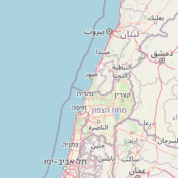
Map view of Tyre Coast Nature Reserve

Use this park location map to pinpoint Tyre Coast Nature Reserve in Lebanon, understand its exact geographic position, and read its mapped placement within the surrounding landscape more clearly.

Pigeon | © OpenStreetMap contributors
Park atlas

Explore the Surrounding Regional Geography and Coastal Protected Landscapes

Discover More Protected Areas Near Tyre Coast Nature Reserve, Lebanon

Continue your exploration of coastal protected areas and their diverse geography surrounding Tyre Coast Nature Reserve, Lebanon. Browse an expanded atlas view of nearby national parks and other conservation landscapes, allowing for comparison of unique ecosystems, from wetlands and springs to crucial sea turtle nesting sites across the region.
Nature reserveNabatieh District
About 22 km away#1 closest

East

Wadi al-Hujeir Nature Reserve: Protected Terrain and Mediterranean Woodland Geography

Highland valley landscape in the Nabatieh District of Southern Lebanon

Wadi al-Hujeir is a significant nature reserve characterized by its mature Valonia oak forests and ancient olive groves. This valley serves as a critical protected landscape, offering deep insight into the regional geography and Mediterranean woodland ecosystems of Southern Lebanon.

Area
26 km²
Established
2010
Relief
Upland
Climate
Mediterranean
National parkIsrael
About 28 km away#2 closest

South

Yehi'am Fortress National Park: National Park with Protected Landscape Identity in Israel

Discover its mapped geographic boundaries and regional landscape context.

Yehi'am Fortress National Park is a key protected area situated within the geographic landscape of Israel. This national park entry provides structured insights into its distinct natural features and its role as a mapped protected zone. Explore the regional context and unique geographic identity of Yehi'am Fortress National Park, contributing to a broader understanding of Israel's conservation landscapes.

Relief
Upland
Access
Moderate access
Scope
Terrestrial
Water
No major water
National parkIsrael
About 30 km away#3 closest

Southeast

Bar'am National Park: Preserving Ancient Jewish Heritage and Galilee Landscape

Explore significant Talmudic-era synagogues and borderland geography.

Bar'am National Park is an important archaeological site in Israel's upper Galilee, renowned for its remarkably preserved ancient Jewish synagogues dating to the Talmudic period. These structures represent significant tangible evidence of Jewish religious life and architectural styles from late antiquity. Situated amidst the rolling hills of the Galilee countryside, the park's landscape offers a unique combination of historical reflection and scenic views towards the Lebanese border, making it a key destination for understanding regional heritage and geography.

Relief
Upland
Access
Moderate access
Scope
Terrestrial
Water
No major water
Watercolor painting with green, pink, yellow, and white areas depicting terrain and water
National parkIsrael
About 39 km away#4 closest

East

Hurshat Tal National Park: Ancient Valonia Oak Forest and Protected Landscape Identity

Explore mapped boundaries and geographic context in Israel's Hula Valley.

Hurshat Tal National Park is a protected area in northern Israel’s Hula Valley, distinguished by its extraordinary grove of ancient Valonia oak trees, some dating back 350 to 400 years. This site offers a rare look at a living forest heritage, serving a dual role as a crucial nature conservation zone and a popular family recreational destination with facilities like accommodation and swimming areas, making it a unique feature on any park atlas.

Area
0.765 km²
Established
1968
IUCN
V
Relief
Lowland
Biosphere reserveLebanon
About 39 km away#5 closest

Northeast

Jabal Rihane Biosphere Reserve: Exploring Lebanon's Protected Mountainous Geography

Discover mapped boundaries and regional landscape context.

Jabal Rihane Biosphere Reserve is a protected natural area vital to Lebanon's conservation efforts. Situated in the mountainous north, it showcases the region's characteristic terrain and Mediterranean hillside environments. Understanding Jabal Rihane's geographic identity through its mapped boundaries and ecological role provides crucial context for exploring Lebanon's protected lands and natural heritage within the eastern Mediterranean.

Area
184.3 km²
Established
2007
IUCN
VI
Relief
Mountain
National parkIsrael
About 42 km away#6 closest

Southeast

Tel Hazor National Park: Protected Landscape Details and Geographic Atlas Context

Explore the mapped boundaries and regional character of this Israeli national park.

Tel Hazor National Park is a protected national park entity situated within the geography of Israel. This page provides detailed information on its protected landscape, emphasizing its mapped boundaries and contribution to regional natural landscape context. Discover the geographic identity of Tel Hazor National Park and its significance for atlas exploration of protected areas in the Levant.

Relief
Upland
Scope
Mixed
Water
Minor water
National parkGolan Heights
About 45 km away#7 closest

East

Hermon National Park: National Park with Distinct Protected Landscape in Golan Heights

Explore its mapped boundaries and regional geographic context.

Hermon National Park is a designated national park contributing to the rich tapestry of protected landscapes within the Golan Heights. This entity offers a focused entry into understanding its specific geographic setting, mapped terrain, and its significance as a protected area. Users can explore the natural features and regional context that define Hermon National Park, enhancing their atlas-based discovery of Israel's conservation lands.

IUCN
V
Watercolor illustration of green mountains, a river, and trees with distant hills under a yellow sky
National parkIsrael
About 47 km away#8 closest

East

Nimrod Fortress National Park: Protected Landscape and Geographic Context in Israel

Explore the mapped boundaries and natural terrain of this Israeli national park.

Nimrod Fortress National Park is a protected area in Israel offering a unique lens through which to explore its regional geography and landscape character. This atlas-focused presentation details the park's protected status and its place within the broader mapped terrain. Understand the significance of its geographic setting and the extent of its protected boundaries for landscape discovery.

Relief
Mountain
Access
Easy access
Scope
Terrestrial
Water
Minor water

Common questions about visiting, size, designation, and location context for Tyre Coast Nature Reserve

Tyre Coast Nature Reserve FAQs for park facts, access, geography, and protected area context

Find quick answers about Tyre Coast Nature Reserve, including protected-area facts, park geography, trail and visitor context, and how the park fits into its surrounding country and regional landscape.
MoriAtlas Explorer

Continue Your Protected Areas Search Across the Global Atlas

Deepen your exploration by continuing the structured search for national parks and protected areas worldwide. Utilize the comprehensive filtering capabilities to compare different conservation landscapes and refine your understanding of global park geography. Discover more about the distribution and characteristics of protected natural areas.

Global natural geography