
Why Manawatāwhi / Three Kings Islands stands out
The Three Kings Islands are best known for their extraordinary biological endemism, far exceeding what would be expected from island groups of similar size and latitude. About 35 percent of beetle species found here occur nowhere else on Earth, and the islands support several endemic insect genera as well as Falla's skink, a reptile unique to the group. Botanically, the islands are famous as the last refuge of Pennantia baylisiana, a kaikomako tree once reduced to a single wild specimen and since propagated as an icon of plant conservation. The islands are equally well known for their dramatic physical setting: an isolated chain of steep, cliff-bound volcanic islands rising from deep ocean, surrounded by exceptionally clear waters. Together, this combination of geological isolation, intact ecosystems, and profound cultural meaning for Muriwhenua Māori gives the group a distinct identity among New Zealand's protected natural areas.
Manawatāwhi / Three Kings Islands history and protected-area timeline
During the Last Glacial Maximum, when sea levels were more than 100 metres lower than at present, almost all of New Zealand's offshore islands were connected to the mainland. The Three Kings Islands, however, although linked to each other by lower sea levels, were not joined to the rest of New Zealand. As sea levels rose around 7,000 years ago, the individual islands within the group became separated, shaping the modern archipelago.
Manawatāwhi was traditionally settled and used by Muriwhenua Māori, especially Te Aupōuri and Ngāti Kurī. The Māori name Manawatāwhi, meaning 'panting breath', is associated in oral tradition with the ancestor Rauru, who was said to have swum to the islands and arrived exhausted. Members of Ngāti Kurī used the islands as a refuge during periods of warfare and as a place to harvest hāpuku, seabirds, and eggs. Most of the larger islands were inhabited at various times, and Great Island was cleared of vegetation for kūmara cultivation, a transformation that Dutch explorers later observed.
Dutch navigator Abel Tasman became the first known European to sight the islands in late 1642, naming the largest 'Drie Koningen Eyland' on 6 January 1643 after the biblical feast of the Epiphany that coincided with his visit. Tasman anchored offshore seeking fresh water and made sketches of the islands that remain among the earliest European records of any part of New Zealand. The names Three Kings and Cape Maria van Diemen are the only two geographic features in New Zealand still bearing the names Tasman gave them. Later European visitors, including the French botanist Jacques Labillardière in 1793, documented the islands' condition over the following centuries.
In the late 1700s, a party of mainland Te Aupōuri under Taiakiaki travelled to the islands and killed the resident population of around 100 people. Sporadic contacts followed between 1800 and 1830, and the sealer Tame Porena settled on Great Island with a large family in the 1830s and 1840s before starvation forced them back to the mainland. After that, no permanent settlement was attempted. The New Zealand government purchased the islands from seven Māori owners in 1908, declared them an animal sanctuary in 1930, and formally reserved them for the preservation of flora and fauna in 1956.
Manawatāwhi / Three Kings Islands landscape and geographic character
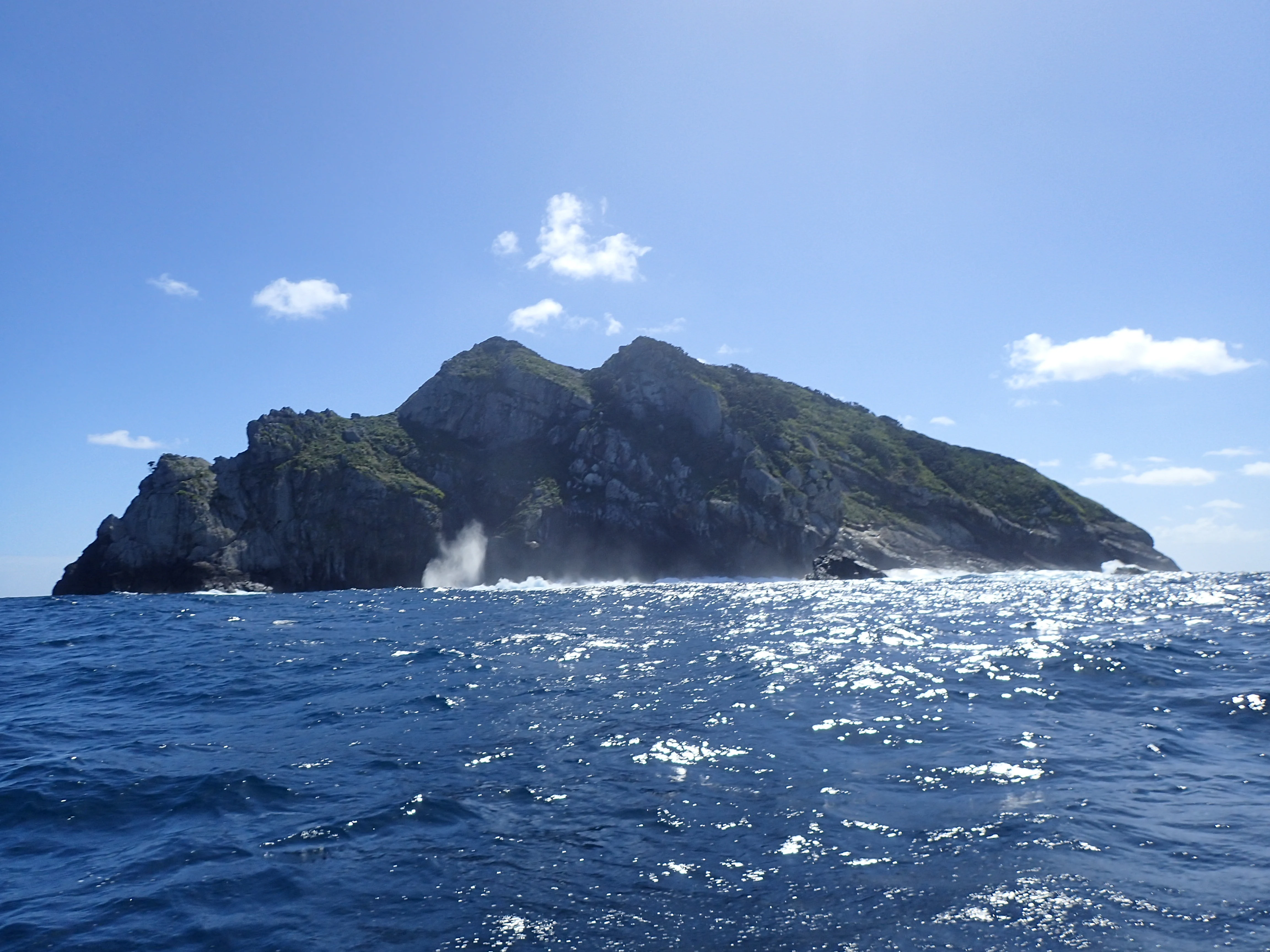
The Three Kings Islands rise abruptly from very deep ocean waters as a cluster of steep, cliff-edged volcanic landforms. The group falls into two main subgroups, each sitting on the Three Kings Bank. The King Group in the northeast contains the largest landmass, Manawatāwhi or Great Island, along with Oromaki / North East Island and the tiny Farmer Rocks, while the Southwest Group includes Moekawa / South West Island, the chain of small islets known as The Princes Islands, and the smaller Ōhau / West Island.
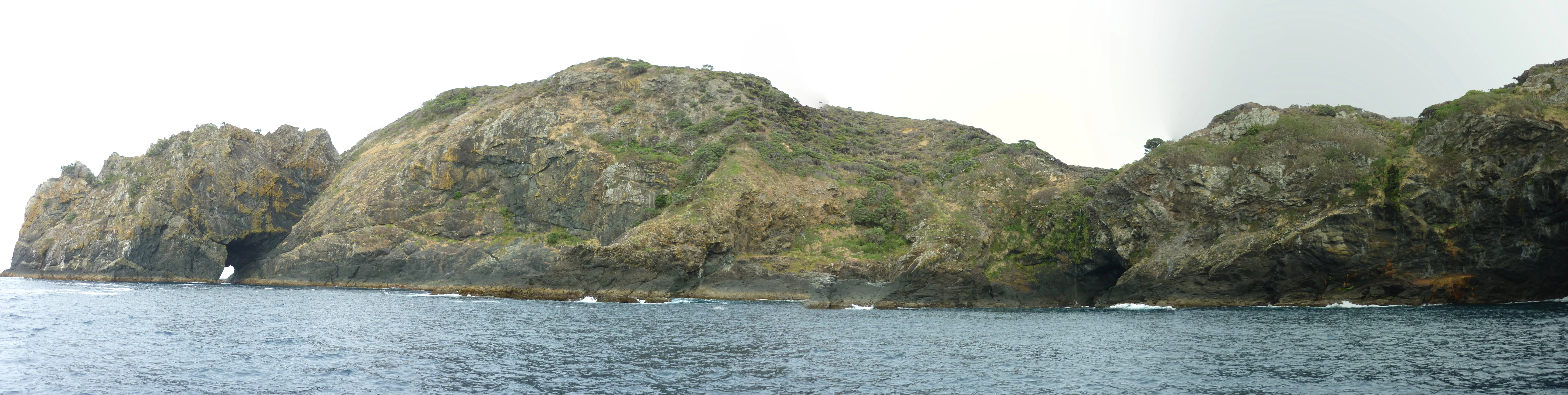
Manawatāwhi / Great Island dominates the archipelago at roughly 4 square kilometres. Its northeastern peninsula is nearly severed by deep bays that almost meet across a high, narrow isthmus, giving the island a distinctive twin-character. Much of the southern portion is shaped by the Tasman Valley, an area of rolling hills drained by the Tasman Stream, with elevated western terrain reaching 295 metres above sea level. All of the major islands are surrounded by imposing cliffs, often between 70 and 130 metres high, and there are no beaches anywhere in the group, which means that landing is restricted to a few difficult points. Spectacular features include deep clefts, plunging coastal cliffs falling directly into clear deep water, and small islets lined up in chains above tide lines of jagged rock.
Manawatāwhi / Three Kings Islands ecosystems, habitats, and plant life
The natural character of the Three Kings Islands is defined by extreme isolation combined with relatively undisturbed terrestrial and marine ecosystems. The vegetation reflects a history of Māori clearance on Great Island followed by partial reforestation, and includes open coastal communities, regenerating forest, and a notably small flora that nonetheless contains a striking number of endemics. Several plant species found here have been documented nowhere else in the world, and others were reduced to single wild specimens by browsing animals before conservation intervention.
The marine environment is equally distinctive. The islands rise from extremely deep water onto a relatively shallow submarine plateau, and the surrounding sea is known for unusually high visibility and abundant fish life. These conditions support communities of reef fish and invertebrates that include species found only around the Three Kings, such as the endemic mollusc Haliotis pirimoana, the Manawatāwhi pāua, and other invertebrates with restricted ranges. Genetic research suggests that the surrounding marine and terrestrial fauna has had complex evolutionary connections to Australia, New Caledonia, and the broader Pacific, rather than to mainland New Zealand.
Manawatāwhi / Three Kings Islands wildlife and species highlights
The Three Kings Islands support one of the most striking levels of endemism found in any New Zealand island group, with particularly high diversity among invertebrates. Roughly 35 percent of the beetle species recorded here are found nowhere else, and the islands contain at least six endemic insect genera, with additional undescribed endemic genera likely. Endemic groups include ground beetles, rove beetles, darkling beetles, and fungus weevils. Falla's skink, Oligosoma fallai, is a reptile found only on these islands and is one of New Zealand's most distinctive island-bound lizards.
The surrounding marine fauna is similarly significant. Endemic marine invertebrates include the mollusc Haliotis pirimoana, the Manawatāwhi pāua, and the snail Penion lineatus, along with other locally restricted species. Seabirds nest on the cliffs and rock stacks, taking advantage of the absence of introduced mammalian predators. The historical absence of rats and mice, combined with the removal of goats from the largest island, has allowed much of the original character of the wildlife communities to persist.
Manawatāwhi / Three Kings Islands conservation status and protection priorities
Conservation significance at the Three Kings Islands is unusually high for a New Zealand territory because of the islands' combination of geographic isolation, intact ecosystems, and exceptional rate of endemism. The islands have never had rats or mice introduced, which distinguishes them from many other New Zealand offshore islands and has helped preserve native flora and fauna. The vegetation, soils, and wildlife communities have shaped the islands' identity as a refuge for species that have disappeared or declined elsewhere.
A particularly important chapter in the islands' conservation history centres on Pennantia baylisiana, a kaikomako tree discovered in 1945 in what was then the last known wild specimen of its kind, recognised internationally as the rarest tree in the world. Careful propagation efforts eventually established a secure population, although the species continues to require close monitoring. Other endemic plants, including Tecomanthe speciosa and Elingamita johnsonii, also have conservation significance. Goats deliberately released on Great Island in 1889 as a food source for shipwreck survivors multiplied to several hundred animals, severely degrading vegetation. Following government intervention inspired by malacologist Baden Powell, the goats were removed by shooting in 1946, allowing the forest to regenerate. The islands were purchased by the New Zealand government in 1908, declared an animal sanctuary in 1930, gazetted as a flora and fauna reserve in 1956, and designated a nature reserve administered by the Department of Conservation, with wildlife sanctuary status formalised in 1995.
Manawatāwhi / Three Kings Islands cultural meaning and human context
The Three Kings Islands hold deep cultural meaning for Muriwhenua Māori, especially Te Aupōuri and Ngāti Kurī, who traditionally used the islands for seasonal habitation, refuge, and harvesting of seafood, seabirds, and eggs. The Māori name Manawatāwhi for Great Island, meaning 'panting breath', is tied to traditions about the ancestor Rauru, said to have swum to the islands and arrived exhausted. Archaeological traces of Māori life include stonework, terracing, and former garden sites, particularly in the Tasman Valley area, where most of the islands' Māori archaeological features are concentrated.
Perhaps the most widely known cultural association of the group is with the Māori understanding of the journey of the spirits of the dead. Spirits are said to leave the world at Cape Reinga / Te Rerenga Wairua, descend through the roots of a centuries-old pōhutukawa tree, travel beneath the sea, and resurface at Ōhau / West Island, the smallest of the main islands, for a final farewell to Aotearoa before continuing to the ancestral homeland of Hawaiki. This places the Three Kings Islands within one of the most important spiritual geographies in te ao Māori.
Top sights and standout views in Manawatāwhi / Three Kings Islands
An isolated volcanic archipelago with no beaches and no introduced predators, hosting one of the highest rates of endemism in New Zealand, from beetles and an endemic skink to the world's most famous conservation tree. Administered as a nature reserve and wildlife sanctuary by the Department of Conservation, the islands combine dramatic cliff-bound scenery with some of the clearest ocean waters in the New Zealand region, drawing divers to reefs that shelter species found nowhere else.
Just as remarkable is the cultural weight of the group. The smallest main island, Ōhau, is widely regarded in Muriwhenua tradition as the last glimpse of Aotearoa given by departing spirits on their journey to Hawaiki, giving the islands a profound role in Māori spiritual geography alongside their significance as a refuge, harvest ground, and occasional home for generations of Muriwhenua people.
Best time to visit Manawatāwhi / Three Kings Islands
Because the islands are uninhabited and protected as a nature reserve, any visit is restricted in scale and managed by the Department of Conservation, and conditions offshore are the main influence on timing. The surrounding seas are calmer in the warmer months of late spring to early autumn, when access by boat from the northern New Zealand coast is generally easier and underwater visibility tends to be at its best for diving. The cooler months bring rougher conditions and stronger winds, which can make landings on the steep, beachless islands difficult. For purely natural-history interest, late spring and summer are also when seabird colonies are most active and the islands' vegetation is at its lushest.