Mori Atlas logo
Biosphere reserveTierras del Ebro

Discover the geographic intersection of the Ebro River basin, coastal delta wetlands, and rugged limestone massifs.

Tierras del Ebro Biosphere Reserve: Mapping the Protected Landscapes of Southern Catalonia

Tierras del Ebro represents a unique territorial mosaic in southern Catalonia, defined by the lower course of the Ebro River. This designated biosphere reserve encompasses the expansive Ebro Delta wetlands alongside the steep limestone peaks of the Ports de Tortosa-Beseit massif. Through mapped terrain and regional context, examine how this area integrates diverse ecosystems, including coastal lagoons and riverine forests, within a cohesive protected landscape.

biosphere reservewetlandsriver deltaEbro deltacoastal lagoonsrice paddies

Tierras del Ebro

Biosphere reserve

Park overview

Structured park overview, official facts, and landscape profile for Tierras del Ebro

Tierras del Ebro park facts, protected area profile, and essential visitor context

Review the core facts for Tierras del Ebro, including designation, size, terrain, visitor scale, habitats, and operating context in one park-focused overview.

About Tierras del Ebro

Tierras del Ebro is one of the eight territorial functional areas defined in the General Territorial Plan of Catalonia. Stretching across the southernmost part of the autonomous community, it brings together the comarcas of Bajo Ebro, Montsiá, Tierra Alta, and Ribera de Ebro into a territory that is unified by the Ebro River as it approaches and enters the Mediterranean Sea. The river is the defining geographic thread of the region, shaping everything from the inland valleys and reservoirs to the broad coastal plain and the famous delta.

Within this relatively compact territory, two great natural systems dominate the landscape. The Ebro Delta forms a wide coastal plain built up over centuries of river sediment, now a mosaic of rice paddies, coastal lagoons, beaches, dunes, and wetland habitats. Inland and to the west, the Ports de Tortosa-Beseit rise as a long limestone massif, reaching elevations of more than a thousand meters and offering a contrast of cliffs, ravines, and Mediterranean forest that feels almost entirely separate from the delta only a short distance away.

The recognition of most of this territory as a UNESCO Biosphere Reserve in 2013 reinforced a conservation identity that had been building for decades. The Ebro Delta had long been protected as a natural park, while the Ports range was designated a natural park separately and later contributed to the broader biosphere framework. Smaller protected sites, including the Cardó mountains and the Sebes reserve near Flix, add further ecological value and reflect the diversity of habitats compressed into the region.

Culturally, Tierras del Ebro has a strong and distinctive identity. Tortosa, the principal city, preserves a historic center with a cathedral, fortified walls, and old civic buildings, while smaller towns such as Miravet, Horta de San Juan, Arnes, and Alcanar carry their own heritage of medieval castles, cooperative wineries, and traditional rural architecture. The territory also preserves important evidence of older human presence, including Iberian settlements of the Ilercavones people and Levantine rock art sites near Ulldecona and El Perelló that have been inscribed as part of a UNESCO World Heritage designation. The scars and memory of the Battle of the Ebro, one of the longest and most consequential confrontations of the Spanish Civil War, also remain visible across the landscape, giving the territory a complex modern historical layer alongside its natural and pre-modern cultural heritage.

Quick facts and research context for Tierras del Ebro

Tierras del Ebro lies in the southern portion of Catalonia and covers roughly 3,308 square kilometers, representing more than half of the province of Tarragona and over a tenth of Catalonia as a whole. The region is composed of four comarcas and contains 52 municipalities with a combined population of around 190,000 people. Tortosa serves as the principal urban center and hosts the territorial delegation of the Generalitat of Catalonia.

Most of the territory was designated a UNESCO Biosphere Reserve in 2013. The region's environmental importance rests on two large protected natural areas: the Ebro Delta Natural Park along the coast and the Ports de Tortosa-Beseit Natural Park in the inland mountains, complemented by smaller protected zones such as the Cardó range and the Sebes reserve near Flix.

Protection and recognition

Examine the official protection history and designation records for Tierras del Ebro.

Tierras del Ebro Protection Status and Designated Area Records

Tierras del Ebro maintains a documented mixed protection status established through its 2013 designation history. Official records outline the management scope and conservation framework associated with this protected area landscape.

Protection details

Protection scope
Mixed
Designated year
2013
Transboundary protection
No
Park context

Deeper park guide and search-rich context for Tierras del Ebro

Tierras del Ebro history, landscape, wildlife, and travel context

Explore Tierras del Ebro through its history, landscape character, ecosystems, wildlife, conservation priorities, cultural context, and seasonal travel timing in a structured park guide built for atlas discovery and search intent.

Why Tierras del Ebro stands out

Tierras del Ebro is especially known for the Ebro Delta and the Ports de Tortosa-Beseit. The delta is one of the largest wetlands in the western Mediterranean, with broad expanses of rice fields, coastal lagoons, saltmarshes, and sand beaches that together host a remarkable diversity of aquatic birds and seasonal migrants. Inland, the Ports massif provides a sharp environmental contrast, with limestone peaks, deep valleys, Mediterranean forest, and a quieter, more sparsely populated highland character. The territory is also recognized for combining large protected natural areas with a long human history. Historic towns such as Tortosa, Miravet, and Horta de San Juan, medieval castles, ancient Iberian settlements, Levantine rock art sites, and landscapes shaped by the Battle of the Ebro all sit within the same regional framework, giving Tierras del Ebro an unusually rich blend of ecological and cultural significance within Catalonia.

Tierras del Ebro history and protected-area timeline

Tierras del Ebro as a recognized territorial unit emerged through the administrative and planning reforms of Catalonia in the early twenty-first century. It was defined as one of the eight functional territorial areas in the General Territorial Plan of Catalonia, a framework intended to coordinate planning and services across groups of comarcas rather than relying solely on provincial boundaries. Tortosa was designated the seat of the Generalitat's territorial delegation in the region in 2001, and a decentralized office of the Tarragona Provincial Council followed in 2009.

The region's protected natural area history runs somewhat earlier. The Ebro Delta and the Ports de Tortosa-Beseit were both established as natural parks through separate processes during the late twentieth century, reflecting long-standing recognition of their ecological importance. A series of smaller protected sites, including the Cardó range and the Sebes reserve near Flix, added further detail to the region's conservation map.

A defining moment came on 28 May 2013, when UNESCO inscribed most of Tierras del Ebro as a Biosphere Reserve. This designation brought the delta, the Ports massif, surrounding agricultural lands, and inhabited towns into a single internationally recognized framework, highlighting the coexistence of high ecological value with active human settlement, agriculture, and cultural heritage.

The deeper human history of the territory extends much further back. The region preserves Iberian-era sites associated with the Ilercavones culture, including settlements at the Moleta del Remei near Alcanar and the Castellet de Banyoles near Tivisa. Medieval and early modern history is reflected in castles such as that of Miravet, in the historic urban core of Tortosa, and in towns such as Horta de San Juan and Arnes with their heritage of rural architecture and cooperative wine production. The area also contains Levantine rock art in the Ulldecona and El Perelló caves, later inscribed as part of a UNESCO World Heritage listing. The twentieth century left a very different legacy in the form of the Battle of the Ebro during the Spanish Civil War, whose traces still shape how parts of the landscape are remembered and interpreted today.

Tierras del Ebro landscape and geographic character

The landscape of Tierras del Ebro is essentially a story of the Ebro River in three different settings: the steep inland course, the wide agricultural valley, and the coastal delta where the river meets the sea. The river's lower basin cuts through diverse terrain, including narrow gorges in the interior and broad agricultural plains closer to the coast, before spreading out into the delta plain.

The Ebro Delta is the most visually distinctive feature of the region. It forms a broad, mostly flat triangular plain built from river-borne sediment, marked by an extensive network of rice paddies, irrigation channels, coastal lagoons, dunes, beaches, and salt-influenced wetlands. The contrast between the green geometry of the rice fields and the open water of the lagoons and sea is one of the defining images of the territory.

Inland and to the west, the Ports de Tortosa-Beseit massif rises sharply from the river valleys. This limestone range is characterized by steep slopes, deep ravines, cliffs, and relatively high peaks for this part of Catalonia. Its terrain supports dense Mediterranean forest and gives the region a highland counterpart to the soft coastal lowlands. Between these two extremes, the transitional landscapes include the gently sloped agricultural lands of Tierra Alta, the river terraces of the Ribera de Ebro, and the coastal ranges that frame the delta.

The coastline itself runs from the southern delta beaches northward along the Costa del Ebro, with a series of cliffs, coves, and small coastal towns defining the maritime edge of the territory. This combination of river, delta, mountain, agricultural plain, and coastline compressed into one region gives Tierras del Ebro an unusually varied physical geography.

Tierras del Ebro ecosystems, habitats, and plant life

Tierras del Ebro's natural identity is built on the meeting of very different ecosystems within a relatively small area. The Ebro Delta is one of the most significant wetland systems in the western Mediterranean, combining freshwater, brackish, and saline habitats in a single dynamic landscape. Its interwoven lagoons, channels, reedbeds, and saltmarshes support a wide range of aquatic and shore-based life, while the surrounding rice fields add a heavily human-shaped but ecologically productive extension of the wetland environment.

The Ports de Tortosa-Beseit provide a very different ecological context in the interior. Their limestone terrain and varied elevation support Mediterranean forest communities typical of this part of Catalonia, including oak and pine species and the understory plants associated with dry, sunny mountain slopes. The massif acts as a refuge for species that find less suitable habitat in the more agricultural coastal and valley areas.

Between these two large contexts, the region's transitional zones include riverbank habitats along the Ebro and its tributaries, the drier agricultural platforms of Tierra Alta, and smaller mountainous areas like the Cardó range. The Sebes reserve near Flix adds an additional protected fragment of riparian and wetland habitat, illustrating how even narrow ecological corridors along the river have been recognized for their conservation value. The range of altitudes, substrates, and hydrological conditions across the territory gives Tierras del Ebro an unusually rich ecological mosaic despite its modest total size.

Tierras del Ebro wildlife and species highlights

The wildlife profile of Tierras del Ebro is strongly shaped by its wetland habitats, particularly those of the Ebro Delta. The delta hosts large populations of waterbirds, including herons, egrets, ducks, flamingos, and a wide variety of shorebirds, many of which use the area as a wintering ground or as a stopping point on migration routes between Europe and Africa. The combination of open water, reedbeds, and agricultural fields creates a particularly productive feeding environment for these species.

The coastal lagoons and saltmarshes around the delta support species adapted to saline and brackish conditions, while the beaches and dunes provide nesting habitat for certain coastal bird species. Inland, the Ports massif offers a contrasting wildlife context, with forest and rock-dwelling species that thrive in the more rugged terrain, including raptors and other birds associated with Mediterranean mountain habitats.

Smaller protected areas, including the Sebes reserve near Flix and the Cardó range, add further habitat diversity, supporting riverbank species and mountain woodland fauna respectively. Overall, the territory's wildlife value stems less from any single charismatic species than from the breadth and interconnectedness of habitat types that allow very different animal communities to coexist within the same regional framework.

Tierras del Ebro conservation status and protection priorities

The conservation significance of Tierras del Ebro is rooted in the coexistence of large protected natural areas with active human use of the landscape. The most important protected sites are the Ebro Delta Natural Park and the Ports de Tortosa-Beseit Natural Park, both of which were established to safeguard the region's most distinctive ecosystems. These two natural parks, together with smaller reserves such as the Cardó range and the Sebes reserve near Flix, form the core ecological infrastructure of the territory.

The 2013 UNESCO Biosphere Reserve designation expanded this framework considerably. By recognizing most of Tierras del Ebro as a biosphere reserve, the international designation highlighted not only the strictly protected zones but also the buffer and transition areas where agriculture, forestry, fisheries, and towns continue to operate. This model emphasizes the integration of conservation with sustainable human activity, an approach particularly relevant to a region where the delta's traditional rice economy and inland agricultural traditions are themselves part of the cultural and ecological landscape.

From a broader perspective, Tierras del Ebro is important for conservation in Catalonia and in the western Mediterranean because it concentrates high-value wetland, marine-influenced, riverine, and mountain habitats within a single administrative territory. The biosphere reserve framework connects these habitats administratively and ecologically, supporting coordinated management of wetlands, mountains, agricultural lands, and inhabited areas in ways that single-site protection alone cannot achieve.

Tierras del Ebro cultural meaning and human context

The cultural identity of Tierras del Ebro reflects the long human presence along the lower course of the Ebro River. Prehistoric Levantine rock art in sites near Ulldecona and El Perelló is among the most ancient and significant cultural layers of the territory, later included in a UNESCO World Heritage inscription for Mediterranean rock art of the Iberian Peninsula.

In ancient and Iberian times the area was home to the Ilercavones, whose settlements such as the Moleta del Remei near Alcanar and the Castellet de Banyoles near Tivisa remain important archaeological references. The medieval period left a strong architectural legacy, exemplified by the castle of Miravet and the historic core of Tortosa, with its cathedral, walls, and civic buildings forming one of the most significant historic ensembles in southern Catalonia.

Modern rural traditions, including cooperative wine production in Tierra Alta, remain an active part of the territory's identity, with cooperative wineries in towns such as Gandesa and Pinell de Bray serving as both economic and cultural landmarks. The twentieth century brought a very different imprint through the Battle of the Ebro, one of the longest battles of the Spanish Civil War, whose landscapes and memory are still part of how the region understands itself today alongside its natural and pre-modern heritage.

Top sights and standout views in Tierras del Ebro

Tierras del Ebro stands out for integrating two very different but internationally recognized protected landscapes, the wetland mosaic of the Ebro Delta and the limestone massif of the Ports de Tortosa-Beseit, within a single territorial framework. Its UNESCO Biosphere Reserve status recognizes not only these flagship ecosystems but also the broader mosaic of agricultural lands, river valleys, and inhabited towns that connect them.

The territory also offers a layered cultural experience, from prehistoric rock art and Iberian archaeology to medieval castles and historic towns, set against landscapes shaped by traditional agriculture and remembered modern conflict. Few regions in Catalonia combine such ecological variety with such a dense accumulation of historical and cultural layers in so compact an area.

Best time to visit Tierras del Ebro

The character of a visit to Tierras del Ebro changes meaningfully with the seasons, largely because the Ebro Delta is so strongly defined by its wetland life. Spring and autumn tend to be particularly rewarding for wildlife observation, when migratory and wintering birds are most active and temperatures are milder, though specific conditions vary year to year. Summer brings high temperatures, especially inland, but also a vibrant agricultural landscape in the rice-growing areas and lively coastal activity along the Costa del Ebro.

Winter offers quieter conditions and can be an excellent period for observing waterbirds that concentrate in the delta during the colder months. Inland, the Ports massif can be more challenging in winter due to cooler temperatures and occasional snow at higher elevations, while spring brings fresh vegetation and greater wildlife activity to its Mediterranean forests. Visitors interested primarily in landscapes and cultural sites tend to find spring and autumn the most comfortable seasons overall, while those focused on birdlife may prefer the cooler months.
Monthly climate preview

Long-term monthly temperature ranges and precipitation patterns across representative coordinates

Tierras del Ebro Climate Normals, Annual Temperature and Precipitation Rhythm

Representative coordinate records show measured monthly temperature averages ranging from cooler winter minimums to warm summer maximums alongside varying daily precipitation rates. Reviewing the complete twelve-month sequence provides precise historical climatology data for regional analysis.
Annual mean16 °C
8 °C25 °C
Jan
Feb
Mar11°
Apr14°
May18°
Jun22°
Jul25°
Aug25°
Sep21°
Oct17°
Nov11°
Dec
Warmest month
August

25.1 °C

Coolest month
January

7.5 °C

Wettest month
October

1.9 mm/day

Driest month
July

0.6 mm/day

Park location guide

Geography guide, regional context, and park location map for Tierras del Ebro

Tierras del Ebro park geography, regions, and map view in Spain

Understand where Tierras del Ebro sits in Spain through a broader geographic reading of the surrounding landscape, nearby location context, and its mapped position within the national park landscape.

How Tierras del Ebro fits into Spain

Spain, officially the Kingdom of Spain, is a unitary parliamentary constitutional monarchy located in Southern and Western Europe. The country occupies most of the Iberian Peninsula and includes territories in the Mediterranean and Atlantic. With a population of approximately 49.6 million and an area of 506,030 km², Spain is a major European economy and cultural force. Its capital is Madrid, and the country is known for its diverse landscapes ranging from mountainous regions to coastal areas.

Wider geography shaping Tierras del Ebro in Spain

Spain occupies the Iberian Peninsula in Southern and Western Europe. Peninsular Spain is bordered to the north by France, Andorra, and the Bay of Biscay; to the east and south by the Mediterranean Sea and Gibraltar; and to the west by Portugal and the Atlantic Ocean. The territory includes the Canary Islands in the Atlantic Ocean, the Balearic Islands in the Mediterranean Sea, and the autonomous cities of Ceuta and Melilla in mainland Africa. Spain features diverse terrain including the Pyrenees in the northeast, the Sierra Nevada in the south, and the Meseta Central plateau.

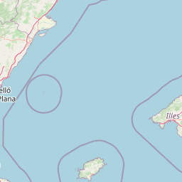
Map view of Tierras del Ebro

Use this park location map to pinpoint Tierras del Ebro in Spain, understand its exact geographic position, and read its mapped placement within the surrounding landscape more clearly.

Pigeon | © OpenStreetMap contributors

Location context for Tierras del Ebro

Catalonia
Park atlas

Compare adjacent wetland reserves, limestone massifs, and regional Mediterranean landscapes.

Parks Near Tierras del Ebro and Related Protected Areas in the Surrounding Region

Browsing other protected areas near Tierras del Ebro reveals broader ecological patterns across the lower Ebro River basin and nearby coastal mountain ranges. Comparing these connected landscapes provides essential context for understanding the varied terrain and regional spread of southern Catalonia.
Watercolor illustration of a mountainous landscape with a river, green vegetation, and distant peaks under a light sky
National parkProvince of Lleida
About 179 km away#1 closest

North

Aigüestortes i Estany de Sant Maurici National Park: Pyrenean High Mountain National Park Landscape

Explore glacial lakes and winding waterways in Catalonia.

Aigüestortes i Estany de Sant Maurici National Park is a premier national park in the Pyrenees, celebrated for its extensive network of almost 200 glacial lakes and the dramatic natural beauty of the Sant Maurici lake. Its landscape is defined by high mountain terrain, characterized by U-shaped valleys, sharp ridges, and unique hydrological features like the Aigüestortes plain's meandering streams. This protected area in the Province of Lleida offers a rich setting for understanding alpine environments and Pyrenean geography through detailed mapping and atlas exploration.

Area
141 km²
Established
1955
IUCN
II
Visitors
525K annual
Watercolor painting showing a mountain range with a winding river through a valley
National parkSpain
About 180 km away#2 closest

North

Ordesa y Monte Perdido National Park: Glacial Terrain and Pyrenean Protected Landscape

Explore its dramatic valleys, cliffs, and alpine geography.

Ordesa y Monte Perdido National Park is a critical protected area within the Pyrenean geography, defined by its spectacular glacial valleys, towering limestone massifs, and unique karst formations. As a National Park and UNESCO World Heritage Site, it offers a rich environment for exploring mapped terrain and understanding the interplay of geology and high-alpine ecosystems. Delve into the mapped boundaries and distinct landscape features that characterize this significant protected landscape.

Area
156.08 km²
Established
1918
IUCN
II
Relief
Mountain
Protected areaAndorra
About 191 km away#3 closest

Northeast

Madriu-Perafita-Claror Valley: Geographic Overview of Andorra's Premier Protected Landscape

An examination of glacial landforms and historic mountain heritage.

Spanning nine percent of Andorra, the Madriu-Perafita-Claror Valley remains a rare example of a preserved Pyrenean cultural landscape. This protected area features granite cliffs, glacial cirques, and historic ironworking remnants, offering a deep look into the environmental legacy of mountain societies within a remote, foot-access-only basin.

Area
42.47 km²
Established
2004
Relief
Mountain
Climate
Alpine
A soft watercolor painting of rolling green hills, distant mountain peaks, and a calm water body against a white background.
National parkOccitanie
About 198 km away#4 closest

North

Pyrénées-Mont Perdu National Park: Alpine Geography and Transboundary Protected Landscapes

Glacial cirques, limestone canyons, and alpine pastoral heritage.

Spanning the high Pyrenees, Pyrénées-Mont Perdu represents a rare union of dramatic geological formations and human cultural heritage. The terrain features vertical limestone walls, deep carved canyons, and expansive cirques that host both diverse alpine ecosystems and active seasonal migration routes. This protected area remains a benchmark for studying the interplay between powerful glacial geography and historic mountain pastoralism in Europe.

Area
306.39 km²
Established
1997
Relief
Mountain
Climate
Alpine
Watercolor painting of a river winding through a valley with green fields, trees, and distant hills
Protected areaAndorra
About 198 km away#5 closest

Northeast

Parc Natural Comunal de les Valls del Comapedrosa: Andorra's Highest Protected Alpine Landscape

Explore the Pyrenean terrain and mapped boundaries of Andorra's summit park.

Parc Natural Comunal de les Valls del Comapedrosa is the primary high-altitude protected area in Andorra, defined by its rugged alpine terrain and the presence of Coma Pedrosa, the country's highest peak. This protected landscape offers a significant geographic anchor for exploring the Pyrenees, highlighting the unique mountain conservation efforts. Its mapped boundaries encompass dramatic valleys and steep ridges, providing a clear context for understanding Andorra's mountainous geography through a structured atlas lens.

Area
15.43 km²
Established
2003
IUCN
IV
Relief
Mountain
National parkHautes-Pyrénées
About 200 km away#6 closest

North

Pyrénées National Park: Protected Landscape & Transboundary Protected Area Atlas

Discover Hautes-Pyrénées' dramatic glacial terrain and alpine environments.

Pyrénées National Park is a significant protected area in France's Hautes-Pyrénées department, renowned for its dramatic glacial cirques, high-altitude lakes, and extensive mountain landscapes. Established as a national park, it offers rich geographic context for atlas exploration, showcasing millions of years of geological formation shaped by tectonic uplift and glacial carving. This park is also notable for its transboundary conservation efforts with Spain, contributing to a broader protected region. Explore its unique terrain, from towering limestone formations to alpine meadows, and understand its place within the Pyrenean mountain range.

Area
458 km²
Established
1967
IUCN
II
Relief
Mountain
A soft, watercolor painting depicting distant purple-hued mountain ranges fading into a pale, warm-toned sky, with light green hills and hints of pine forests in the foreground.
Nature reserveOccitanie
About 214 km away#7 closest

North

Réserve naturelle régionale d'Aulon: Mountain Geography and Protected Area Mapping

A diverse protected landscape spanning the central Pyrenees of Occitanie.

This regional nature reserve provides a focused look at central Pyrenean mountain environments. Covering over 1,200 hectares, the area features a steep altitudinal gradient, blending working pastoral meadows with critical habitats such as rocky slopes, conifer forests, and glacial landforms. The site serves as a vital anchor within the broader network of protected mountain terrain found throughout the Occitanie region.

Area
12.37 km²
Established
2001
IUCN
IV
Relief
Mountain
A watercolor painting of a serene mountain landscape featuring gentle rolling hills, small clusters of trees, and soft, muted tones of green, pink, and purple, set against a light background.
Nature reserveOccitanie
About 216 km away#8 closest

North

Réserve naturelle régionale du Massif du Montious: Regional Nature Reserve in Occitanie

Granitic massif geography and Pyrenean protected landscapes

Located in the heart of the Hautes-Pyrénées, this reserve captures the geological and biological essence of the Central Pyrenees. From the summit grasslands at 2,171 metres to the sheltered glacial basins, the terrain provides a comprehensive look at regional mountain ecosystems and Hercynian geological heritage.

Area
7.38 km²
Established
2020
IUCN
IV

Common questions about visiting, size, designation, and location context for Tierras del Ebro

Tierras del Ebro FAQs for park facts, access, geography, and protected area context

Find quick answers about Tierras del Ebro, including protected-area facts, park geography, trail and visitor context, and how the park fits into its surrounding country and regional landscape.
MoriAtlas Explorer

Continue Your Protected Areas Search Across the Global Atlas

Deepen your exploration by continuing the structured search for national parks and protected areas worldwide. Utilize the comprehensive filtering capabilities to compare different conservation landscapes and refine your understanding of global park geography. Discover more about the distribution and characteristics of protected natural areas.

Global natural geography