Mori Atlas logo
National parkTowarri National Park

Discover the geographic setting and park boundaries of Towarri National Park in New South Wales.

Towarri National Park National Park: Mapped Boundaries and Protected Landscape Geography

Towarri National Park represents a significant protected area within the geographic expanse of New South Wales, Australia. This page provides detailed atlas-level insights into its protected landscape, mapped boundaries, and regional context, offering a foundation for understanding its place within Australia's natural geography and conservation areas. Explore the inherent geographic identity of this national park.

National ParkNew South WalesBird HabitatEndangered SpeciesTemperate ForestHighland Landscape

Towarri National Park

National park

Park overview

Structured park overview, official facts, and landscape profile for Towarri National Park

Towarri National Park park facts, protected area profile, and essential visitor context
Review the core facts for Towarri National Park, including designation, size, terrain, visitor scale, habitats, and operating context in one park-focused overview.

About Towarri National Park

Towarri National Park occupies a meaningful position within New South Wales's protected area network, representing the characteristic highland ecosystems of the Barrington Tops region. The park's terrain consists of rolling hills and gentle ridges, with elevation varying across the landscape to create diverse microhabitats. The vegetation reflects the transitional nature of the area between the coastal ranges and the western slopes, supporting plant species typical of both environments. The park's establishment in 1999 (effective 1998) reflected growing recognition of the need to preserve the region's biodiversity and wilderness character. Visitors to Towarri experience a landscape that remains relatively undeveloped, with walking tracks providing access to key areas of interest. The park contributes to regional ecological connectivity, linking with other protected lands in the broader Barrington Tops area to form a more comprehensive conservation framework.

Quick facts and research context for Towarri National Park

Towarri National Park spans 36.39 square kilometres in the Barrington Tops area of northern New South Wales, positioned about 230 kilometres north of Sydney. The terrain features gentle to moderate slopes with an average elevation of 502 metres above sea level, characteristic of the New England Tableland landscape. The park was gazetted in 1998 and is managed by the National Parks and Wildlife Service (NSW). It holds IUCN Category II protected area status, reflecting its national park designation and conservation significance.

Park context

Deeper park guide and search-rich context for Towarri National Park

Towarri National Park history, landscape, wildlife, and travel context
Explore Towarri National Park through its history, landscape character, ecosystems, wildlife, conservation priorities, cultural context, and seasonal travel timing in a structured park guide built for atlas discovery and search intent.

Why Towarri National Park stands out

Towarri National Park is distinguished by its mosaic of plant vegetation types and its role as a habitat for diverse birdlife, including the endangered speckled warbler. The park's vegetation includes various plant communities adapted to the cool, elevated conditions of the New England region, ranging from open forests to heathy woodland assemblages. The speckled warbler, listed as endangered in New South Wales, finds refuge within the park's protective boundaries, making Towarri particularly significant for avian conservation in the state.

Towarri National Park history and protected-area timeline

Towarri National Park was formally declared in 1998, adding to the collection of national parks that protect New South Wales's natural heritage. The park's creation came as part of ongoing efforts by the National Parks and Wildlife Service to identify and protect areas of ecological significance across the state. The Barrington Tops region had already seen the establishment of several protected areas, and Towarri was designated to preserve additional highland terrain and its associated biodiversity values. Management of the park falls under the National Parks and Wildlife Service, which operates under the framework of the National Parks and Wildlife Act to ensure appropriate conservation outcomes.

Towarri National Park landscape and geographic character

The landscape of Towarri National Park reflects the characteristic topography of the New England Tableland region in northern New South Wales. The terrain consists of undulating hills and ridges with gentle slopes, averaging around 502 metres in elevation. This elevated setting places the park within a cool temperate climate zone that influences the types of vegetation and ecological communities present. The park lacks dramatic peaks or steep cliff systems, instead presenting a more subtle terrain of rolling forested hills and open woodland areas. The landscape supports a variety of plant communities that have adapted to the local conditions, creating a park environment that feels distinctly representative of highland New South Wales.

Towarri National Park ecosystems, habitats, and plant life

The ecological character of Towarri National Park is defined by its diverse plant vegetation communities that thrive in the cool, elevated conditions of the New England region. The park supports a mosaic of vegetation types, including areas of dry sclerophyll forest, heathy woodland, and grassy open areas. These varied habitats create conditions suitable for a range of plant and animal species, contributing to the park's biodiversity value. The transitional nature of the location, situated between different botanical provinces, means the park contains elements from multiple vegetation suites. This diversity of plant life forms the foundation for the park's ecological significance, supporting the various bird and animal species that depend on these habitats for food and shelter.

Towarri National Park wildlife and species highlights

Towarri National Park serves as an important habitat for birdlife, with the park supporting populations of numerous species. Of particular conservation significance is the speckled warbler, a small bird species listed as endangered in New South Wales, which finds suitable habitat within the park's boundaries. The diverse vegetation communities provide foraging opportunities and nesting sites for various bird species, making the park a meaningful location for avian biodiversity. Beyond birds, the park's forests and woodlands support other wildlife adapted to the highland environment, contributing to the overall ecological value of the protected area.

Towarri National Park conservation status and protection priorities

The designation of Towarri National Park as an IUCN Category II protected area reflects its recognized conservation significance within the New South Wales park system. The park plays a role in protecting the biodiversity of the Barrington Tops region, preserving habitat for endangered species such as the speckled warbler. The variety of vegetation communities present within the park contributes to conservation outcomes by maintaining ecosystem diversity and the ecological processes that depend on these habitats. Management by the National Parks and Wildlife Service ensures that conservation objectives guide decisions about access, development, and resource use within the park.

Towarri National Park cultural meaning and human context

The Barrington Tops region has historical associations with Aboriginal peoples, though the specific cultural history of the Towarri area is not extensively detailed in available sources. The broader highland region of New South Wales contains evidence of Indigenous occupation and traditional connection to the landscape. As with many New South Wales national parks, the cultural context forms part of the park's broader significance, even where specific historical documentation may be limited.

Top sights and standout views in Towarri National Park

The standout quality of Towarri National Park lies in its representation of New England highland ecosystems and its role as a refuge for endangered bird species. The park offers visitors the opportunity to explore diverse vegetation communities in a relatively undisturbed wilderness setting. The presence of the endangered speckled warbler elevates the park's conservation significance, while the varied plant life provides visual diversity across the landscape. The park offers walking opportunities through forested areas, allowing visitors to experience the character of this elevated New South Wales landscape.

Best time to visit Towarri National Park

The best time to explore Towarri National Park aligns with the cooler months of autumn and spring, when mild temperatures make outdoor activity comfortable and the park's vegetation displays seasonal variety. Summer months can bring warm conditions to the inland highland areas, while winter may result in cold weather and potentially limited access to some areas. The park can be visited year-round, though spring and autumn generally offer the most pleasant conditions for walking and wildlife observation.
Park location guide

Geography guide, regional context, and park location map for Towarri National Park

Towarri National Park park geography, regions, and map view in Australia
Understand where Towarri National Park sits in Australia through a broader geographic reading of the surrounding landscape, nearby location context, and its mapped position within the national park landscape.

How Towarri National Park fits into Australia

Australia is a constitutional monarchy and federal parliamentary democracy comprising six states and ten territories. With a population of nearly 28 million, it is one of the world's most urbanised countries, with most people concentrated on the eastern seaboard. The country has a high Human Development Index and is known for its cultural diversity, ancient Aboriginal heritage, and unique wildlife.

Wider geography shaping Towarri National Park in Australia

Australia occupies the entire Australian continent, the island of Tasmania, and numerous smaller islands. It is the world's flattest and driest inhabited continent, featuring vast deserts in the interior (the Outback), tropical rainforests along the eastern coast, and a coastline bordering the Indian and Pacific Oceans.

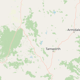
Map view of Towarri National Park

Use this park location map to pinpoint Towarri National Park in Australia, understand its exact geographic position, and read its mapped placement within the surrounding landscape more clearly.

Pigeon | © OpenStreetMap contributors

Location context for Towarri National Park

New South Wales
Park atlas

Map the diverse protected landscapes of Australia's New England Tableland, comparing adjacent conservation areas.

Discover National Parks and Protected Areas Surrounding Towarri National Park in New South Wales
Continue your exploration of Australia's wilderness by browsing other national parks and protected areas near Towarri National Park, focusing on the broader New South Wales highland ecosystems. Compare their unique terrain, diverse vegetation communities, and conservation significance within the expansive New England Tableland region.
National parkNew South Wales

Coolah Tops National Park: Protected Landscape and Geographic Identity on the Liverpool Range

Explore New South Wales's elevated wilderness, waterfalls, and unique forests.

Coolah Tops National Park preserves a distinctive highland environment on the Liverpool Range, offering a protected wilderness experience within New South Wales. This national park is defined by its plateau landscape, featuring steep escarpments, numerous waterfalls, and dense eucalyptus forests. Its geographic position provides a striking contrast to the lower Liverpool Plains, showcasing unique flora and significant habitat for species like the greater glider, making it a vital area for regional landscape and protected-area exploration.

Established
1996
IUCN
II
Relief
Upland
Access
Moderate access
National parkNew South Wales

Goulburn River National Park: New South Wales National Park with River Ecosystems and Heritage

Explore mapped protected lands and regional geography.

Goulburn River National Park offers a significant protected landscape within New South Wales, Australia, celebrated for its expansive Goulburn River frontage and diverse natural terrain. This national park is pivotal for understanding regional geography, featuring sandstone geological formations and serving as a critical habitat for endangered species, including the regent honeyeater. Its extensive river corridor also protects numerous Aboriginal heritage sites, contributing a rich layer of cultural significance to its conservation value. MoriAtlas helps users explore the mapped boundaries and environmental context of this vital protected area.

Area
722.96 km²
Established
1983
IUCN
II
Relief
Mixed relief
National parkAustralia

Yarrobil National Park: Australia's Protected Landscape for Geographic Discovery

Explore its national park designation and mapped regional context.

Yarrobil National Park stands as a distinct protected landscape within Australia, identified as a national park. Its geographic significance lies in its contribution to the nation's atlas of conservation areas. This page focuses on providing a clear understanding of the park's identity, its environmental setting, and how its mapped boundaries fit into the broader regional geography of Australia, enabling structured exploration for enthusiasts of protected areas and natural landscapes.

Area
13.22 km²
Established
2005
IUCN
II
Relief
Upland
National parkNew South Wales

Garrawilla National Park: New South Wales Protected Woodland Ecosystems & Regional Geography

Explore mapped boundaries and native vegetation in this inland Australian national park.

Garrawilla National Park represents a significant protected landscape in New South Wales, Australia, dedicated to conserving semi-arid woodland terrain and characteristic native grass communities. Established to safeguard these vital ecosystems, the park offers insights into the natural heritage of the Central West region's geography. Users can explore its specific geographic footprint and understand its contribution to the preservation of inland Australian vegetation, providing a clear picture of its protected area identity.

Area
9.37 km²
Established
2005
IUCN
II
Scope
Terrestrial
National parkNew South Wales

Ben Halls Gap National Park: Ancient Eucalyptus Forest Protected Landscape in New South Wales

Explore mapped boundaries of old-growth woodland terrain.

Ben Halls Gap National Park represents an ecologically vital strict nature reserve within New South Wales, Australia. It is distinguished by its extensive ancient eucalyptus forests, which are among the most ecologically significant old-growth woodland environments in eastern Australia. Managed primarily for conservation and research, the park's rugged terrain provides a critical habitat refuge and a key reference ecosystem for understanding undisturbed woodland dynamics and biodiversity.

Area
30.18 km²
Established
1995
IUCN
Ia
Scope
Terrestrial
National parkNew South Wales

Wollemi National Park: Mapping Australia's Protected Natural Landscape in New South Wales

Detailed geographic context and protected area exploration.

Wollemi National Park is a critical component of New South Wales' protected natural areas, offering rich opportunities for geographic discovery. This national park provides a distinct focus for understanding the mapped terrain and regional landscape context of Australia. Explore its position within New South Wales, uncovering the details that define its unique protected status and natural geography for dedicated atlas exploration.

Area
5,017.03 km²
Established
1979
IUCN
Ib
Relief
Mountain
National parkNew South Wales

Mount Royal National Park: A National Park in New South Wales for Geographic Discovery

Explore its protected boundaries and landscape context.

Mount Royal National Park is a key protected area in New South Wales, offering an opportunity to delve into its specific geographic identity and mapped landscape features. As a national park, it provides structured data for understanding protected lands within Australia. This detailed entry supports exploration of the park's unique regional context and its contribution to the broader atlas of natural landscapes.

Area
69 km²
Established
1997
IUCN
II
Relief
Mountain
Watercolor illustration of a river flowing through hills with distant mountains and pink trees
National parkNew South Wales

Barrington Tops National Park: A Protected National Park in New South Wales

Explore ancient Gondwana rainforests and dramatic volcanic terrain.

Barrington Tops National Park represents a significant protected landscape in New South Wales, Australia, offering a deep dive into diverse ecosystems. Its unique altitudinal vegetation gradient supports the southernmost subtropical rainforests in Australia and showcases geological formations dating back millions of years. This park is crucial for understanding Australia's natural heritage, providing a rich context for landscape exploration and the study of ancient flora within a mapped geographic setting.

Area
765.12 km²
Established
1969
IUCN
Ib
Relief
Mountain

Common questions about visiting, size, designation, and location context for Towarri National Park

Towarri National Park FAQs for park facts, access, geography, and protected area context
Find quick answers about Towarri National Park, including protected-area facts, park geography, trail and visitor context, and how the park fits into its surrounding country and regional landscape.
MoriAtlas Explorer

Continue Your Protected Areas Search Across the Global Atlas

Deepen your exploration by continuing the structured search for national parks and protected areas worldwide. Utilize the comprehensive filtering capabilities to compare different conservation landscapes and refine your understanding of global park geography. Discover more about the distribution and characteristics of protected natural areas.

Global natural geography