Mori Atlas logo
Protected landscapeVjosa-Nartë Protected Landscape

A coastal mosaic of lagoons, pine forests, and sand dunes in southwestern Albania

Vjosa-Nartë Protected Landscape: Mapping the Adriatic Coast and Vjosa River Delta Geography

Vjosa-Nartë Protected Landscape encompasses a unique coastal geography where the wild Vjosa River delta meets the shallow waters of the Narta Lagoon. This protected area reveals a complex environment of brackish marshes, pine-covered sand dunes, and expansive saltpans along the Adriatic coast. Users can examine the physical boundaries of this wetland system, observing how seasonal changes shape the tidal mudflats and the essential habitats connecting the river mouth to the sea.

coastal wetlandAdriatic coastlagoonsaltpanssand dunesMediterranean pine forest

Vjosa-Nartë Protected Landscape

Protected landscape

Park overview

Structured park overview, official facts, and landscape profile for Vjosa-Nartë Protected Landscape

Vjosa-Nartë Protected Landscape park facts, protected area profile, and essential visitor context

Review the core facts for Vjosa-Nartë Protected Landscape, including designation, size, terrain, visitor scale, habitats, and operating context in one park-focused overview.

About Vjosa-Nartë Protected Landscape

Vjosa–Nartë Protected Landscape is a coastal and deltaic reserve in south-western Albania that protects the converging landscapes of the Vjosa River mouth, the Narta Lagoon and a stretch of the Adriatic shoreline. Stretching between Vlorë and the Strait of Otranto, the reserve combines shallow brackish water, mudflats, sand dunes, pine forest, reedbeds, freshwater marshes, saltpans, agricultural land and small communities into a single protected landscape system. The result is a versatile wetland reserve where Mediterranean coastal habitats meet a functioning river delta.

The protected area was first established on 22 October 2004, when Albanian authorities declared the Vjosë–Nartë wetland system a protected water-and-land landscape. In subsequent government acts, the reserve has also been referred to under the name Pishë Poro–Nartë Protected Landscape, and its legal status has been reaffirmed and reorganized through decisions in 2022 and 2024, keeping it firmly within IUCN Category V as a protected landscape/seascape. The Albanian National Agency of Protected Areas acts as the governing body, and the reserve is recognized internationally as an Important Bird Area and as an Emerald Network site under the Bern Convention.

Ecologically, Vjosa–Nartë stands out for the richness of its birdlife. The Narta Lagoon is one of Albania's premier waterbird sites, particularly for wintering populations and species using the Adriatic Flyway, and records note the regular presence of more than 34,000 wintering waterbirds. Beyond its ornithological importance, the protected landscape supports notable terrestrial and marine fauna, including globally threatened species recorded under the Convention on the Conservation of Migratory Species (CMS), such as the Dalmatian pelican, lesser kestrel, European roller, Audouin's gull, loggerhead sea turtle and Mediterranean monk seal.

Human presence is woven into the reserve's identity. Traditional fishing, salt production, agriculture, grazing and small-scale settlements such as Nartë and Zvërnec have shaped the wetland for generations. The wooden footbridge to Zvërnec Island and its medieval Orthodox monastery remain an iconic cultural landmark within the protected landscape. In recent years, however, the reserve has also gained wider prominence as a focal point of conservation debate in Albania, especially around the construction of Vlora International Airport within its boundaries since 2021 and the 2026 protests tied to the Flamingo Revolution, where flamingos and other wetland species became powerful symbols against large-scale coastal development.

Quick facts and research context for Vjosa-Nartë Protected Landscape

Vjosa–Nartë Protected Landscape lies in Vlorë County on the Albanian Adriatic coast, centred on the Narta Lagoon and the lower Vjosa River delta. It was originally declared as a protected water-and-land landscape in October 2004 and reaffirmed as a Category V protected landscape through Albanian government decisions in 2022 and 2024. Governance is handled by Albania's National Agency of Protected Areas, and the area is recognized internationally as an Important Bird Area and as a candidate Emerald Network site under the Bern Convention.

The landscape covers several thousand hectares, with the 2024 designation setting it at roughly 16,124 hectares; earlier documents and the World Database on Protected Areas report somewhat larger figures. The reserve combines brackish lagoon habitat, salt production areas, sand dunes, Mediterranean pine woodland, reedbeds, freshwater wetlands and traditional coastal settlements, and is widely regarded as one of Albania's most significant sites for migratory and wintering birds.

Protection and recognition

Documented terrestrial protection scope, designation history, and official database metrics

Vjosa-Narte Protected Landscape Protection Status and Designation Records

Vjosa-Narte Protected Landscape maintains a documented terrestrial protection status established in two thousand twenty four. Official registry records outline the designated management scope and reference specific conservation database metrics.

Protection details

Protection scope
Terrestrial
Designated year
2024
Transboundary protection
No
WDPA ID
196506
Park context

Deeper park guide and search-rich context for Vjosa-Nartë Protected Landscape

Vjosa-Nartë Protected Landscape history, landscape, wildlife, and travel context

Explore Vjosa-Nartë Protected Landscape through its history, landscape character, ecosystems, wildlife, conservation priorities, cultural context, and seasonal travel timing in a structured park guide built for atlas discovery and search intent.

Why Vjosa-Nartë Protected Landscape stands out

The park is best known for the Narta Lagoon complex, one of Albania's largest and most important coastal wetlands, which hosts tens of thousands of wintering waterbirds and supports a rich mix of breeding, migrating and overwintering species. It is also recognized for the meeting point between the Vjosa River, often described as Europe's last major wild river, and the Adriatic Sea, producing a distinctive mosaic of delta, lagoon, saltpan and dune habitats. Flamingos, Dalmatian pelicans, lesser kestrels, European rollers and Audouin's gull are among the high-profile species that have helped elevate the area's international conservation profile.

Vjosa-Nartë Protected Landscape history and protected-area timeline

The protected landscape was first established on 22 October 2004, when Albanian authorities recognized the Vjosë–Nartë wetland system as a protected water-and-land landscape. The original 2004 designation set out roughly 19,738 hectares of wetland, forest, agricultural, urban and water surfaces, including an airport area, setting the foundation for the reserve's long-term legal protection.

In the years that followed, Albanian official acts continued to reference the area under a slightly different institutional name, Pishë Poro–Nartë Protected Landscape, while the international World Database on Protected Areas lists it under site ID 196506 (Vjose-Narte). In 2022, Albania's National Agency of Protected Areas described the natural/wetland ecosystem of Pishë Poro–Nartë as a Category V Protected Landscape under Decision No. 694 of 26 October 2022, framing it as both an Emerald Network site and an Important Bird Area. On 25 September 2024, Decision No. 596 of the Council of Ministers re-declared Pishë Poro–Nartë as a water/land protected landscape, set the area at 16,124.61 hectares and repealed the 2022 decision, providing the most recent formal baseline for the reserve's extent and category.

The landscape's modern history has been inseparable from national debates over development. Announcement of the Vlora International Airport project north of the Narta Lagoon in 2018, with construction beginning in late 2021, has placed the reserve at the center of conflict between infrastructure expansion and ecological protection. By 2023, the European Commission's Albania Report and the Standing Committee of the Bern Convention had raised concerns about the airport's environmental impact assessment, while in 2026 controversy over large-scale coastal tourism development near the protected wetland became the spark for the Flamingo Revolution, an Albanian protest movement that linked environmental, anti-corruption and anti-government demands and brought the reserve international attention.

Vjosa-Nartë Protected Landscape landscape and geographic character

Vjosa–Nartë occupies a narrow coastal strip where the Vjosa River empties into the Adriatic Sea, just north of the Bay of Vlorë and not far from the Strait of Otranto. Its physical setting is shaped by the meeting of three landscape elements: the Vjosa delta, the Narta Lagoon and a sandy coastal barrier that separates the lagoon from the open sea. The result is a layered geography of river mouth, shallow brackish water, exposed mudflats, dunes, pine-forested ridges and Mediterranean dryland.

The Narta Lagoon itself is a large, shallow brackish lake connected to the Adriatic by two artificial channels and bordered by a narrow sandy peninsula. Surrounding the lagoon are salinas and saltpans, reedbeds and freshwater marshes, low coastal dunes that can reach roughly eight metres in height, and patches of Mediterranean pine forest dominated by Aleppo pine, maritime pine and stone pine. On the lagoon's islands and sheltered edges, holm oak and other Mediterranean evergreen vegetation become more prominent, creating a varied woodland mosaic against the wetland.

Coastal dunes, pine forest and agricultural land together make the reserve a textbook example of Mediterranean coastal wetland scenery: quiet lagoons framed by pine-covered sand ridges, open saltpans stretching toward small villages, and tidal mudflats where seasonal drawdown exposes rich feeding grounds for birds. The presence of the medieval Zvërnec Monastery on its island, reached across a long wooden footbridge, adds a memorable human landmark to an otherwise intact wetland horizon.

Vjosa-Nartë Protected Landscape ecosystems, habitats, and plant life

Vjosa–Nartë is fundamentally a Mediterranean coastal wetland ecosystem, in which freshwater, brackish and saline habitats coexist within a small geographic area. This unusual mix of water types is one of the main reasons the reserve supports such high biodiversity; within a relatively limited space, it offers river delta, lagoon, marsh, saltpan, dune and pine-woodland environments, each contributing different ecological roles.

The aquatic vegetation of the saltpans and lagoon margins includes characteristic halophyte communities such as Salicornia, Arthrocnemum and Limonium, which colonize the saline flats. Pine-dominated forest covers a modest share of the total land area but forms a defining backdrop along the coastal dunes and sandy barrier, with Aleppo, maritime and stone pine the main species on the mainland, while the islands tend to support holm oak and other Mediterranean evergreens. Where freshwater influence persists, reedbeds and marshy stretches add a third vegetation layer.

The protected area sits firmly on the Adriatic Flyway, a key migration corridor for birds moving between Europe and Africa, and its ecological importance is recognized through several international designations. A government-level inventory highlights thousands of vascular plant species in the wider region, while the protected landscape itself has been identified as an Emerald Network candidate site by the Bern Convention, as an Important Bird Area, and as meeting Ramsar numerical criteria for wintering waterbirds. The combination of diverse habitats and varied water chemistry gives the reserve an unusually layered ecological character compared with purely marine or purely freshwater protected areas in Albania.

Vjosa-Nartë Protected Landscape wildlife and species highlights

Vjosa–Nartë's wildlife profile is dominated by birds. The Narta Lagoon and its surrounding saltpans and mudflats are widely regarded as one of the most important waterbird sites in Albania, with surveys documenting more than 34,000 wintering waterbirds at the site. The combination of shallow brackish water, saline flats and adjacent freshwater marshes makes the reserve a year-round hub for waterbirds, supporting breeding, migrating and overwintering species that use the Adriatic Flyway between Europe and Africa.

Among the most emblematic species are flamingos, which famously inspired the name of the 2026 protest movement, and the Dalmatian pelican, both of which find critical habitat in the lagoon. Other internationally significant species recorded in the protected landscape include the lesser kestrel, European roller and Audouin's gull, all listed under the Convention on the Conservation of Migratory Species (CMS). Beyond birds, the reserve's coastal waters and beaches provide habitat for the loggerhead sea turtle and historically for the Mediterranean monk seal, while inland habitats support mammals such as the golden jackal, and dolphins have been noted in adjacent marine waters.

The overall faunal inventory recorded in the wider Albanian documentation linked to this protected area includes representatives across multiple vertebrate groups, from mammals and reptiles to amphibians and fish, alongside a rich invertebrate fauna associated with the wetland. This breadth reinforces the reserve's identity as an unusually complete Mediterranean coastal ecosystem, where marine, freshwater and terrestrial wildlife meet within a single landscape.

Vjosa-Nartë Protected Landscape conservation status and protection priorities

Vjosa–Nartë is a conservation priority at both national and European scales. Nationally, the reserve has been protected as a Category V protected landscape since 2004, reaffirmed by Decisions No. 694 (2022) and No. 596 (2024), and is managed by Albania's National Agency of Protected Areas. Internationally, the area is recognized as an Important Bird Area designated "Narta Lagoon," as an Emerald Network candidate site (AL0000008) under the Bern Convention, and as a wetland that meets Ramsar numerical criteria for wintering waterbirds. The World Database on Protected Areas lists the site under ID 196506.

The protected landscape's conservation value is closely tied to its role as a staging and wintering ground on the Adriatic Flyway, where large numbers of waterbirds depend on the lagoon, saltpans and mudflats. The area also provides one of the few remaining brackish Mediterranean coastal wetland complexes along the eastern Adriatic, making it important for halophyte vegetation, coastal dunes, and pine-forest habitats that are increasingly rare in heavily developed coastlines elsewhere in the region.

Conservation of the reserve has been heavily contested in recent years. Construction of Vlora International Airport began inside the protected area in December 2021, prompting criticism from Albanian and international environmental groups, concerns expressed in the European Commission's 2023 Albania Report, and recommendations from the Standing Committee of the Bern Convention for suspension of construction pending a more rigorous environmental impact assessment. The 2026 Flamingo Revolution protests over proposed luxury coastal tourism near the reserve extended these concerns into broader public debate, reinforcing the protected landscape's position as one of the most closely watched conservation sites in Albania.

Vjosa-Nartë Protected Landscape cultural meaning and human context

Human presence has shaped Vjosa–Nartë for centuries, and the protected landscape remains a working cultural landscape rather than an uninhabited wilderness. Traditional fishing in the lagoon, salt production in the salinas, small-scale agriculture on reclaimed coastal land and grazing on the dune fringes all continue alongside ecological protection, and the 2024 Albanian decision explicitly allows traditional fishing, cultural activities, ecotourism and certain agrotourism structures, provided they fit the protected-area management framework.

Small communities such as Nartë on the lagoon shore and Zvërnec on the approach to the island monastery form part of the reserve's lived landscape. The Zvërnec Monastery, a medieval Orthodox religious building on Zvërnec Island inside the Narta Lagoon, is one of the most recognizable cultural landmarks of the wider protected area, and the long wooden footbridge linking the island to the mainland has become an iconic visual signature of the wetland.

In recent years, the reserve has also taken on a strong contemporary cultural meaning. The 2026 Flamingo Revolution, which began with protests near Zvërnec against the fencing of an undeveloped coastal stretch for a luxury tourism project, transformed the protected landscape into a national symbol. Flamingos, pelicans and the wider wetland became visual rallying points for a movement that combined ecological protection with demands against corruption and opaque real-estate development, embedding Vjosa–Nartë into modern Albanian civic and political identity alongside its older religious and rural heritage.

Top sights and standout views in Vjosa-Nartë Protected Landscape

The protected landscape's standout features include the Narta Lagoon, one of Albania's largest and most ecologically important coastal wetlands; a layered mosaic of lagoon, saltpan, dune, marsh and Mediterranean pine habitats within a short coastal stretch; the Vjosa River delta, where one of Europe's best-known wild rivers meets the Adriatic Sea; and the Zvërnec Monastery and its wooden footbridge on the lagoon island, which anchor the area's cultural identity. Internationally, the reserve is a recognized Important Bird Area, an Emerald Network site and a Ramsar-qualifying waterbird site, with Dalmatian pelicans, flamingos and lesser kestrels among its most charismatic species. At the same time, its modern history is inseparable from major national debates over the Vlora International Airport and the 2026 Flamingo Revolution protests, giving the reserve an unusually high public profile for a coastal wetland of its size.

Best time to visit Vjosa-Nartë Protected Landscape

The reserve has a Mediterranean climate, with mild, relatively wet winters and hot, dry summers, and its character shifts distinctly between seasons. Winter and early spring are widely considered the richest periods for visiting naturalists, when the lagoon and its saltpans host large numbers of wintering and migratory waterbirds and the surrounding salt flats and mudflats are most exposed as water levels drop.

Late spring and early summer offer warm, dry conditions suitable for exploring the pine forest, dunes and cultural sites such as the Zvërnec Monastery, though bird activity is more dispersed at this time. Summer can be very hot and dry, with reduced water levels concentrating birds in smaller areas of remaining wetland; visitation is possible but should be planned around peak heat. Autumn again brings renewed bird movement along the Adriatic Flyway, making it another favourable window for wildlife-focused visits.
Monthly climate preview

Examine measured long-term temperature ranges and monthly precipitation cycles across the representative coordinate.

Vjosa-Nartë Protected Landscape Climate Normals and Annual Weather Patterns

Representative coordinate records show measured monthly temperature variations alongside shifting precipitation rates across the landscape. Reviewing the complete twelve-month climate profile provides deeper context for long-term environmental patterns at this protected location.
Annual mean17 °C
10 °C26 °C
Jan10°
Feb10°
Mar12°
Apr14°
May18°
Jun23°
Jul25°
Aug26°
Sep22°
Oct19°
Nov15°
Dec11°
Warmest month
August

25.7 °C

Coolest month
January

9.5 °C

Wettest month
November

4.4 mm/day

Driest month
July

0.7 mm/day

Park location guide

Geography guide, regional context, and park location map for Vjosa-Nartë Protected Landscape

Vjosa-Nartë Protected Landscape park geography, regions, and map view in Albania

Understand where Vjosa-Nartë Protected Landscape sits in Albania through a broader geographic reading of the surrounding landscape, nearby location context, and its mapped position within the national park landscape.

How Vjosa-Nartë Protected Landscape fits into Albania

Albania is a unitary parliamentary republic in Southeast Europe, situated on the Balkan Peninsula along the Adriatic and Ionian coastal regions. With a population of approximately 2.4 million people, it borders Montenegro, Kosovo, North Macedonia, and Greece. The country features varied landscapes ranging from the Albanian Alps to fertile coastal plains, with Tirana as its capital and largest city.

Wider geography shaping Vjosa-Nartë Protected Landscape in Albania

Albania occupies the western part of the Balkan Peninsula in Southeast Europe. The country features a varied terrain with rugged mountain ranges including the Albanian Alps (Accursed Mountains), Korab, Skanderbeg Mountains, Pindus, and Ceraunian Mountains. Fertile lowland plains extend along the Adriatic and Ionian coastal regions. The country borders Montenegro to the northwest, Kosovo to the northeast, North Macedonia to the east, and Greece to the south.

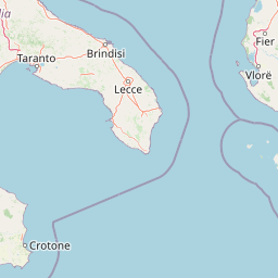
Map view of Vjosa-Nartë Protected Landscape

Use this park location map to pinpoint Vjosa-Nartë Protected Landscape in Albania, understand its exact geographic position, and read its mapped placement within the surrounding landscape more clearly.

Pigeon | © OpenStreetMap contributors
Park atlas

Compare nearby protected areas and surrounding regional wetland landscapes

Parks Near Vjosa-Nartë Protected Landscape And Related Coastal Reserves

Browsing parks near Vjosa-Nartë Protected Landscape reveals connected coastal reserves and regional wetland habitats along the Adriatic Flyway. Comparing adjacent protected areas provides deeper geographic context for Mediterranean river deltas and wildlife migration corridors.
Watercolor scene featuring a blue lake, green trees, and mountains under a yellow-pink sky
National parkAlbania
About 11 km away#1 closest

South

Karaburun-Sazan Marine Park: A National Park with Dramatic Limestone Cliffs and Island Ecosystems

Explore Albania's protected coastline and marine geography.

Karaburun-Sazan Marine Park, Albania's sole national park, offers a profound exploration of a unique protected landscape. This marine protected area combines the rugged Karaburun Peninsula, characterized by high limestone cliffs, with Sazan Island, Albania's largest island, known for its distinct geology and subtropical climate. The park's waters are critical habitats for endangered species, making it a significant site for marine biodiversity and regional geographic study. Discover the mapped boundaries and ecological context of this vital protected area.

Area
124.377 km²
Established
2010
IUCN
II
Relief
Mixed relief
A soft watercolor painting of a coastal landscape with green hills meeting a light, abstract water or shoreline, with faint mountains in the background.
Nature reserveVlorë County
About 15 km away#2 closest

South

Karaburun Peninsula Nature Reserve: Mapping the Coastal Karst and Marine Landscapes

Protected rugged cliffs in Vlorë County, Albania

Karaburun Peninsula is a significant protected area defined by high limestone ridges and a heavily indented western shoreline. The terrain features numerous sea caves, historic bays, and prominent headlands that descend directly into the sea. As a vital nature reserve, it preserves the natural integrity of this mountainous coastal stretch within Vlorë County, offering a clear geographic overview of one of Albania's most remote wilderness areas.

Area
62 km²
Relief
Mountain
Climate
Mediterranean
Access
Moderate access
Watercolor painting depicting mountains, forests, and valleys
National parkVlorë County
About 31 km away#3 closest

Southeast

Llogara National Park: Vlorë County's Dramatic Ceraunian Mountain Protected Landscape

Explore Albania's rugged national park geography and mapped terrain.

Llogara National Park stands as a vital protected area within Vlorë County, Albania, renowned for its spectacular Ceraunian Mountain topography. This page provides access to detailed geographic information, highlighting the park's unique landscape characteristics, from alpine peaks to coastal vistas. Discover the mapped extent of this national park and its significance within the regional geography, perfect for structured atlas exploration.

Area
17.69 km²
Established
1966
IUCN
II
Relief
Mountain
Watercolor painting showing hills, green fields, a body of water, and vegetation under a soft sky
National parkAlbania
About 40 km away#4 closest

North

Divjakë-Karavasta National Park: Albania's Expansive Coastal Wetland and Pelican Breeding Site

Mapping Albania's largest Mediterranean lagoon and its vital bird sanctuaries.

Divjakë-Karavasta National Park is a key protected coastal wetland in western Albania, centered around Karavasta Lagoon, one of the largest in the Mediterranean. This Ramsar site provides critical habitats for numerous bird species, including a globally significant population of the endangered Dalmatian pelican, making it a premier destination for understanding regional wetland geography and protected area dynamics.

Area
222.3 km²
Established
2007
IUCN
II
Relief
Lowland
Watercolor painting showing mountains, a river, and vegetation
National parkAlbania
About 60 km away#5 closest

Northeast

Tomorr Mountain National Park: Sacred Peak & Karst Protected Landscape in Albania

Explore Albania's dramatic mountain geography and protected areas.

Tomorr Mountain National Park offers a unique exploration of southern Albania's dramatic limestone anticline. Dominated by the sacred Mount Tomorr and featuring the spectacular Osum Canyon, this national park provides insight into karst terrain, old-growth forests, and significant biodiversity. Discover its mapped boundaries and regional geographic context within the Pindus Mountains for structured atlas exploration.

Area
271.855 km²
Established
1956
IUCN
II
Relief
Mountain
Watercolor painting showing a river valley with mountain ranges in the background and green fields
National parkGjirokastër County
About 62 km away#6 closest

East

Vjosa Wild River National Park: Europe's Pioneer Free-Flowing River Protected Area

Mapping dynamic canyons and vital river ecosystems in Gjirokastër County.

Vjosa Wild River National Park is recognized as Europe's first Wild River National Park, a groundbreaking designation protecting an entire river system from source to sea. This protected area in Gjirokastër County preserves remarkable topography, including dramatic canyons, natural rapids, and meandering islands, all shaped by the free flow of the Vjosa River and its tributaries. Explore the mapped boundaries and unique landscape context of this significant biodiversity hotspot, offering a crucial case study for river conservation and atlas discovery.

Area
127.27 km²
Established
2023
IUCN
II
Relief
Mixed relief
A pale, soft-hued watercolor illustration of a natural landscape featuring rolling hills, a small waterfall, and sparse trees on a white background.
Protected areaAlbania
About 62 km away#7 closest

East

Bogovë Nature Park: Protected Limestone Hills and Waterfall Geography in Southern Albania

Regional protected area within the Balkan forest ecoregion

Bogovë Nature Park protects 330 hectares of diverse Mediterranean forest and dramatic limestone ravines. Central to its identity are the cascading waterfalls and karst topography that characterize this portion of the Pindus Mountains mixed forests ecoregion in southern Albania, providing a significant example of Balkan woodland preservation.

Area
3.3 km²
Established
1977
IUCN
IV
Relief
Mountain
Watercolor painting of a landscape with green fields, scattered trees, and rolling hills under a light sky
National parkGjirokastër County
About 87 km away#8 closest

East

Fir of Hotovë-Dangëlli National Park: Ancient Forests & Mountain Wilderness Atlas

Explore a premier protected landscape in Gjirokastër County, Albania.

Fir of Hotovë-Dangëlli National Park stands as a monumental protected area, celebrated for its exceptional old-growth Hotova Fir forests, which are a rare Mediterranean plant relic. This national park in Gjirokastër County offers a detailed look at a vast mountainous terrain, featuring dramatic canyons like Lengarica Canyon, and serving as a critical habitat for diverse wildlife. MoriAtlas provides structured geographic context for this significant landscape, highlighting its mapped boundaries and role as a key component of regional protected area networks.

Area
360.038 km²
Established
2008
IUCN
II
Relief
Mountain

Common questions about visiting, size, designation, and location context for Vjosa-Nartë Protected Landscape

Vjosa-Nartë Protected Landscape FAQs for park facts, access, geography, and protected area context

Find quick answers about Vjosa-Nartë Protected Landscape, including protected-area facts, park geography, trail and visitor context, and how the park fits into its surrounding country and regional landscape.
MoriAtlas Explorer

Continue Your Protected Areas Search Across the Global Atlas

Deepen your exploration by continuing the structured search for national parks and protected areas worldwide. Utilize the comprehensive filtering capabilities to compare different conservation landscapes and refine your understanding of global park geography. Discover more about the distribution and characteristics of protected natural areas.

Global natural geography