
Mori Atlas logo
Natural monumentVottovaara

Tracing the mapped boundaries and high-upland terrain of the West Karelian Upland

Vottovaara National Park: A Geological and Protected Landscape in the Republic of Karelia

Vottovaara rises as a distinctive quartzite ridge within the Republic of Karelia, serving as the highest peak of the West Karelian Upland. The massif features a flat-topped plateau shaped by glacial processes, resulting in vast fields of erratic boulders and balancing stones. This protected area now encompasses the central mountain complex along with surrounding lake and taiga environments, offering deep insight into the geology of the Fennoscandian Shield.

Karelian highlandsquartzite massifglacial erraticsboulder fieldsbalancing stonestaiga forest
A stylized vector illustration featuring a large, balanced boulder perched on a cliff edge, surrounded by evergreen trees and a distant mountain waterfall.

Vottovaara

Natural monument

Park overview

Structured park overview, official facts, and landscape profile for Vottovaara

Vottovaara park facts, protected area profile, and essential visitor context

Review the core facts for Vottovaara, including designation, size, terrain, visitor scale, habitats, and operating context in one park-focused overview.

About Vottovaara

Vottovaara sits in the southeastern part of Muyezersky District in the Republic of Karelia, about 32 kilometers southeast of the settlement of Sukkozero, 20 kilometers northeast of Gimoly, and roughly 40 kilometers southwest of the large Segozero reservoir. The mountain is the highest point of the West Karelian Upland, reaching an elevation of approximately 417 meters above sea level and covering about 6 square kilometers.

Geologically, the massif lies within the western flank of the Yangozero synclinorium, the second largest structural unit on the Karelian craton after the Onega synclinorium. Vottovaara itself is a ridge elongated in a roughly north-south direction for about 7 kilometers, composed of jatulic quartzites and quartzite sandstones, and broken by numerous faults that may have been renewed after the last glaciation. This bedrock setting, combined with the weight of Pleistocene ice sheets and the deeply fractured rock, has produced the chaotic surface of rounded glacial erratics that defines the mountain today.

Ecologically, the surroundings remain strongly Karelian: a mix of taiga forest, mires, and lake basins typical of the region. The 2023 federal designation of Vottovaara National Park brought together three distinct clusters under one protection framework: the core rocky massif, the territory around Lake Pizanets, and the forested landscape surrounding the Kiviyarvi and Pirolampi lake system. Cultural heritage recognition at the federal level further underlines the combined natural and historical value of the site.

Beyond its official status, Vottovaara has acquired a strong place in Russian popular imagination, drawing visitors interested not only in geology and Karelian nature but also in the unresolved questions about the mountain's stone structures and their possible ritual, archaeological, or pseudohistorical meanings.

Protection and recognition

Examine the established terrestrial protection framework and designation timeline for Vottovaara.

Vottovaara Protection Status and Designated Terrestrial Conservation History

Vottovaara maintains a documented terrestrial protection status established in the year 2011. Structured records outline the official management scope and designation history for this protected area.

Protection details

Protection scope
Terrestrial
Designated year
2011
Transboundary protection
No
Park context

Deeper park guide and search-rich context for Vottovaara

Vottovaara history, landscape, wildlife, and travel context

Explore Vottovaara through its history, landscape character, ecosystems, wildlife, conservation priorities, cultural context, and seasonal travel timing in a structured park guide built for atlas discovery and search intent.

Why Vottovaara stands out

Vottovaara is primarily known for the vast field of large erratic boulders and balancing stones that sprawl across its plateau, along with the persistent debate over whether the most striking arrangements are natural, archaeological, or modern fabrications. It is also recognized as the highest peak of the West Karelian Upland, rising sharply above surrounding taiga, lakes, and low-relief Karelian terrain.
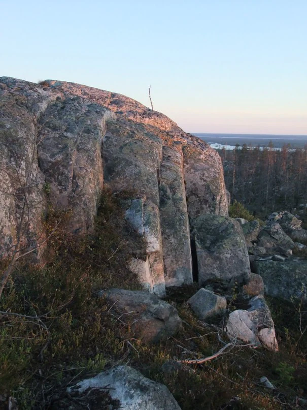
A large, weathered rock face featuring vertical fissures and nearby scattered boulders set against a backdrop of distant forest and a pale horizon at dusk.
Large glacial stone formations on the rocky, elevated terrain of Vottovaara, Karelia.

Vottovaara history and protected-area timeline

Vottovaara entered modern public awareness in the late 1970s, when the local Sukkozero researcher S. M. Simonyan first drew attention to the unusual concentration of stones on the plateau and suggested that some of the arrangements might be man-made. In the early 1990s, archaeologists M. M. Shakhnovich and I. S. Manyukhin conducted field surveys and argued that certain stone configurations were cult structures associated with the ancient Saami population, an interpretation that spread through publications and popular media and attracted wider interest from both researchers and enthusiasts of mystical and fringe subjects.

Subsequent archaeological work has been more cautious. Senior researchers at the Institute of Language, Literature and History of the Karelian Scientific Center of the Russian Academy of Sciences have concluded that the stone groups can largely be divided between natural formations and relatively recent fabrications built either for mystification or as informal visitor marks, while pointing out that no synchronous Stone Age settlements or other material traces of ancient Saami populations have been documented in the immediate vicinity of the mountain.

A formal turning point came on 3 August 2011, when the government of the Republic of Karelia designated the Vottovaara natural complex as a landscape natural monument covering more than 1,500 hectares. The site was also listed as a federal cultural heritage object of Russia. On 20 October 2023, the Russian federal government established the Vottovaara National Park across parts of Muyezersky and Medvezhyegorsk districts, consolidating protection of the massif and adjacent lake and forest territories into a unified management framework.

Vottovaara landscape and geographic character

Vottovaara's defining landscape is a flat-topped rocky massif rising through the surrounding Karelian taiga, with summit elevations in the range of roughly 417 meters above sea level. The ridge is elongated in a roughly north-south direction for about 7 kilometers and forms the highest point of the West Karelian Upland, the broader highland belt that occupies western central Karelia.

The plateau surface is the most visually distinctive part of the mountain. Glacial action during the Pleistocene and the fractured quartzite bedrock together produced dense fields of large, rounded erratic boulders, scattered singly, stacked in groups, and in some cases leaning on smaller stones in seemingly precarious balances. Intermittently the boulders give way to exposed quartzite slabs, small boggy hollows, and thin pine-dominated woodland typical of subarctic upland settings. The surrounding lowlands descend into the lake-studded Karelian forest landscape, with nearby Segozero providing a major hydrological reference point.

Vottovaara ecosystems, habitats, and plant life

The natural environment around Vottovaara is characteristic of central Karelia: extensive boreal taiga dominated by pine and spruce, interspersed with mires, peatlands, and a dense network of lakes. The massif itself stands above this forest and wetland matrix as a rocky island, with thin, stony soils that support a sparse cover of low trees, lichens, and mosses rather than closed forest.

The broader protected territory, formalized in 2023 as Vottovaara National Park, adds lake and forest clusters to the core massif, including areas around Lake Pizanets and the forested landscape around Kiviyarvi and Pirolampi. These lake and woodland settings preserve the wider Karelian mosaic of upland taiga, paludified lowlands, and lake basins that is increasingly important as a reference for northern European taiga ecosystems.

Vottovaara conservation status and protection priorities

Vottovaara's modern conservation story is one of layered designations. In 2011, the Republic of Karelia declared the Vottovaara natural complex a landscape natural monument, giving formal protection to the mountain and an area of more than 1,500 hectares that includes surrounding terrain. The site was also added to Russia's federal register of cultural heritage objects, reflecting the combined natural and archaeological interest in the mountain.

In 2023, the Russian federal government elevated protection further by establishing Vottovaara National Park across parts of Muyezersky and Medvezhyegorsk districts. The national park encompasses three distinct clusters: the core rocky massif, the territory around Lake Pizanets, and the forested landscape around Kiviyarvi and Pirolampi. This larger framework positions Vottovaara as a long-term reference site for Karelian taiga, rocky upland, and lake basin ecosystems, alongside its role as a place of contested but persistent cultural significance.

Vottovaara cultural meaning and human context

Vottovaara carries a layered cultural meaning that extends well beyond its natural interest. The toponym itself is of Saami origin, combining a Saami stem associated with victory or overcoming with the word for mountain that is shared, in related forms, across Saami, Karelian, and Finnish languages.

The mountain has become a focal point of an ongoing debate about ancient Saami ritual activity. Early investigators argued that certain boulder arrangements on the plateau were cult structures associated with ancient Saami practice, an interpretation widely echoed in popular Russian-language sources. Mainstream archaeological assessment now treats most of these structures as natural formations or modern fabrications, while the cultural resonance of the site, including its appeal to mystical and quasi-scientific audiences, has nonetheless become a defining part of its modern identity.

Top sights and standout views in Vottovaara

Vottovaara's standout quality is the extraordinary surface of its plateau: a sweeping expanse of glacial erratics, balancing stones, and clustered boulders set on one of the highest points of the West Karelian Upland. This unusual geological stage is paired with the mountain's status as the highest point of its highland region and with a federal landscape natural monument designation that has now been broadened into a multi-cluster national park.

Equally distinctive is Vottovaara's cultural profile. The mountain sits at the intersection of serious geological observation, unresolved questions about ancient Saami presence, and a more recent wave of public interest that draws on folklore, fringe archaeology, and modern mysticism. Visitors encounter not just a Karelian mountain but a place where natural landscape and contested cultural meaning are unusually tightly bound together.

Best time to visit Vottovaara

The Karelian climate gives Vottovaara a short, mild summer and a long cold season dominated by snow. The most approachable window for general outdoor exploration is the snow-free period from late spring through early autumn, when daylight is longest and access roads and tracks are most practical. Snow cover transforms the plateau into a stark, frozen field of boulders and ice, which is visually striking but considerably more demanding for any on-foot visit. Given the remoteness of the massif and the high latitude of the site, visitors should generally expect cool conditions, changing weather, and a limited seasonal window for comfortable exploration.
Monthly climate preview

Long term temperature ranges and monthly precipitation averages recorded across representative park coordinates

Vottovaara Climate Normals, Average Temperature and Monthly Precipitation Patterns

Representative coordinate records show measured temperature swings from sub zero monthly averages to warmer summer highs alongside varying daily precipitation rates. Examining the full twelve month profile reveals detailed climate normals and deeper weather variations across Vottovaara.
Annual mean1 °C
-12 °C16 °C
Jan-12°
Feb-12°
Mar-6°
Apr-1°
May
Jun13°
Jul16°
Aug14°
Sep
Oct
Nov-5°
Dec-10°
Warmest month
July

16.2 °C

Coolest month
January

-12.4 °C

Wettest month
July

3.2 mm/day

Driest month
February

1.5 mm/day

Park location guide

Geography guide, regional context, and park location map for Vottovaara

Vottovaara park geography, regions, and map view in Russia

Understand where Vottovaara sits in Russia through a broader geographic reading of the surrounding landscape, nearby location context, and its mapped position within the national park landscape.

How Vottovaara fits into Russia

Russia is a transcontinental nation spanning eleven time zones, bordered by fourteen countries. It is the world's largest country by area, covering 17,098,246 km². Moscow is the capital and largest city, while Saint Petersburg is the second-largest and a major cultural centre.

Wider geography shaping Vottovaara in Russia

Russia spans Eastern Europe and North Asia, covering 17,098,246 km². It shares land borders with fourteen countries, more than any other nation, and spans eleven time zones. The landscape includes vast plains, mountain ranges such as the Urals and Caucasus, and extensive coastlines along the Arctic Ocean, Pacific Ocean, Baltic Sea, Black Sea, and Caspian Sea.

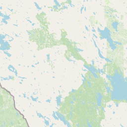
Map view of Vottovaara

Use this park location map to pinpoint Vottovaara in Russia, understand its exact geographic position, and read its mapped placement within the surrounding landscape more clearly.

Pigeon | © OpenStreetMap contributors

Location context for Vottovaara

Republic of Karelia

Visualizing the boulder fields, balancing stones, and taiga ecosystems of the protected area

Vottovaara Photos and Landscapes: Exploring the Karelian Quartzite Massif

Examine detailed Vottovaara images and protected area views to understand the rugged terrain, glacial erratics, and upland topography. Visual records reveal the distinct environmental character of the Karelian mountain and surrounding forest ecosystems.

A large, weathered rock face featuring vertical fissures and nearby scattered boulders set against a backdrop of distant forest and a pale horizon at dusk.

A large, rounded grey boulder balanced on three smaller stones atop a rocky base, with a person sitting nearby for scale and sparse trees in the background.

Park atlas

Compare surrounding Karelian taiga ecosystems and upland geological formations

Explore Protected Areas and National Parks Near Vottovaara

Browsing nearby national parks and protected areas provides broader geographic context for the unique quartzite ridge of Vottovaara. Comparing adjacent forest reserves and highland landscapes reveals the wider ecological patterns of the West Karelian Upland.
Natural monumentRepublic of Karelia
About 0 km away#1 closest

Southwest

Mount Vottovaara Natural Monument: Explore Protected Landscape and Geographic Context in Karelia

Mapped protected area boundaries and regional terrain in the Republic of Karelia.

Mount Vottovaara represents a significant natural monument within the Republic of Karelia, offering a focal point for structured geographic exploration. This protected landscape's mapped boundaries and its setting within the region's broader geography are key to understanding its atlas value. MoriAtlas provides the framework to examine the specific identity of Mount Vottovaara as a protected area, encouraging detailed study of its natural features and regional context.

Area
15 km²
Established
2011
IUCN
III
Relief
Mixed relief
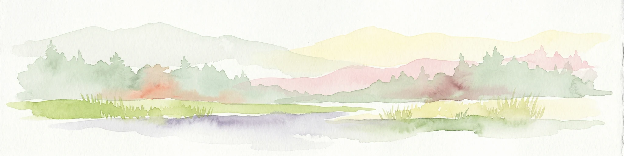
Watercolor illustration of a bog landscape with green trees, a body of water, and rolling hills in the background
National parkNorth Karelia
About 84 km away#2 closest

West

Patvinsuo National Park: Protected Landscape Geography and Map Context

National park exploration in North Karelia, Finland.

Patvinsuo National Park stands as a vital protected area within North Karelia, Finland. This page serves as an atlas entry point, detailing the park's geographic scope, mapped boundaries, and its significance as a protected landscape. Users can explore the regional context and understand the natural terrain that characterizes this important Finnish national park, facilitating structured geographic discovery.

Area
105 km²
Established
1982
IUCN
II
Visitors
18.6K annual
Watercolor illustration of a river flowing through a wetland area with grassy banks, trees, and distant hills
National parkNorth Karelia
About 92 km away#3 closest

Southwest

Petkeljärvi National Park: Distinct Protected Landscape and Esker Formations in North Karelia

Discover Finland's unique esker ridges and boreal forests.

Petkeljärvi National Park represents a distinctive protected landscape in North Karelia, Finland, celebrated for its prominent esker formations that define its topography. The park showcases light Scots pine forests growing on sandy soils, creating an open forest character that sets it apart. Visitors can explore the mapped geography, including winding ridges, wetlands, and lake scenery, alongside preserved historical fortifications from the Continuation War, offering a rich blend of natural and cultural heritage within this compact national park.

Area
7 km²
Established
1956
IUCN
II
Visitors
17.3K annual
Watercolor illustration of a landscape featuring green vegetation, rolling hills, and a body of water under a pastel sky
National parkNorth Karelia
About 132 km away#4 closest

West

Koli National Park: Protected National Park in North Karelia, Finland

Explore mapped landscape and regional geography.

Koli National Park represents a significant protected area within the eastern Finnish region of North Karelia. This page offers detailed geographic context and insight into the park's mapped landscape, essential for understanding its place within the broader atlas of Finland's natural terrain. Discover the protected boundaries and regional setting of this key national park.

Area
30 km²
Established
1991
IUCN
II
Visitors
249.8K annual
Watercolor illustration showing a lake with forested shores and mountains in the background
National parkRepublic of Karelia
About 165 km away#5 closest

Southwest

Ladoga Skerries National Park: National Park Protected Landscape & Geography

Mapped boundaries and regional context in the Republic of Karelia.

Discover Ladoga Skerries National Park, a key protected area recognized as a national park within the Republic of Karelia. This page provides essential context for understanding its mapped boundaries, the natural terrain it encompasses, and its geographical significance within the broader regional landscape. Utilize this information for structured atlas exploration of protected natural environments, focusing on the distinct identity of Ladoga Skerries National Park.

Area
1,220 km²
Established
2017
IUCN
II
Relief
Lowland
A soft, pale green and blue watercolor illustration showing several rocky islands with sparse vegetation surrounded by water, with faint hills in the background.
National parkЯмало-Ненецкий автономный округ
About 165 km away#6 closest

Southwest

Ладожские шхеры National Park: Mapped Geography and Protected Archipelago Boundaries

Coastal skerry landscapes and Lake Ladoga regional terrain

Defined by the ancient Baltic Shield, Ладожские шхеры National Park protects a dense network of rocky islands and glacially carved inlets. This landscape serves as a vital ecological hotspot within Karelia, preserving clean lake waters and forested summits that stand as a geographic exception in the European Russian landscape.

Area
1,220.08 km²
Established
2017
IUCN
II
Relief
Lowland
Watercolor painting depicting a lake surrounded by trees and hills under a soft sky
National parkArkhangelsk Oblast
About 183 km away#7 closest

East

Vodlozersky National Park: A Protected National Park within Arkhangelsk Oblast's Geography

Explore the mapped boundaries and natural landscape of this national park.

Vodlozersky National Park serves as a significant protected landscape within the Arkhangelsk Oblast region. This national park detail page provides focused access to its geographic identity, mapped terrain, and protected area status. Utilize MoriAtlas to understand the specific context of Vodlozersky National Park and its role in the regional atlas of natural areas, enhancing your geographic discovery.

Area
4,280 km²
Established
1991
IUCN
II
Visitors
1K annual
National parkKainuu
About 199 km away#8 closest

Northwest

Hiidenportti National Park: Kainuu Protected Area and Geographic Landscape Context

Explore mapped boundaries and regional geography in eastern Finland.

This MoriAtlas entry details Hiidenportti National Park, a designated national park situated in the Kainuu region of Finland. It serves as a vital hub for understanding the protected area's mapped landscape, its specific geographic characteristics, and its position within the regional atlas of eastern Finland's natural terrain. Dive into the structured details that define Hiidenportti National Park's protected identity and its contribution to the geographic understanding of the taiga-forested regions.

Area
45 km²
Established
1982
IUCN
II
Visitors
11.3K annual

Common questions about visiting, size, designation, and location context for Vottovaara

Vottovaara FAQs for park facts, access, geography, and protected area context

Find quick answers about Vottovaara, including protected-area facts, park geography, trail and visitor context, and how the park fits into its surrounding country and regional landscape.
MoriAtlas Explorer

Continue Your Protected Areas Search Across the Global Atlas

Deepen your exploration by continuing the structured search for national parks and protected areas worldwide. Utilize the comprehensive filtering capabilities to compare different conservation landscapes and refine your understanding of global park geography. Discover more about the distribution and characteristics of protected natural areas.

Global natural geography