
Why Vottovaara stands out
Vottovaara is primarily known for the vast field of large erratic boulders and balancing stones that sprawl across its plateau, along with the persistent debate over whether the most striking arrangements are natural, archaeological, or modern fabrications. It is also recognized as the highest peak of the West Karelian Upland, rising sharply above surrounding taiga, lakes, and low-relief Karelian terrain.
Vottovaara history and protected-area timeline
Vottovaara entered modern public awareness in the late 1970s, when the local Sukkozero researcher S. M. Simonyan first drew attention to the unusual concentration of stones on the plateau and suggested that some of the arrangements might be man-made. In the early 1990s, archaeologists M. M. Shakhnovich and I. S. Manyukhin conducted field surveys and argued that certain stone configurations were cult structures associated with the ancient Saami population, an interpretation that spread through publications and popular media and attracted wider interest from both researchers and enthusiasts of mystical and fringe subjects.
Subsequent archaeological work has been more cautious. Senior researchers at the Institute of Language, Literature and History of the Karelian Scientific Center of the Russian Academy of Sciences have concluded that the stone groups can largely be divided between natural formations and relatively recent fabrications built either for mystification or as informal visitor marks, while pointing out that no synchronous Stone Age settlements or other material traces of ancient Saami populations have been documented in the immediate vicinity of the mountain.
A formal turning point came on 3 August 2011, when the government of the Republic of Karelia designated the Vottovaara natural complex as a landscape natural monument covering more than 1,500 hectares. The site was also listed as a federal cultural heritage object of Russia. On 20 October 2023, the Russian federal government established the Vottovaara National Park across parts of Muyezersky and Medvezhyegorsk districts, consolidating protection of the massif and adjacent lake and forest territories into a unified management framework.
Vottovaara landscape and geographic character
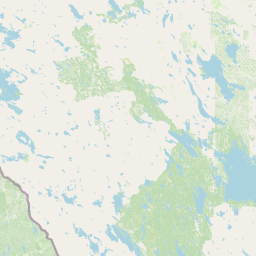
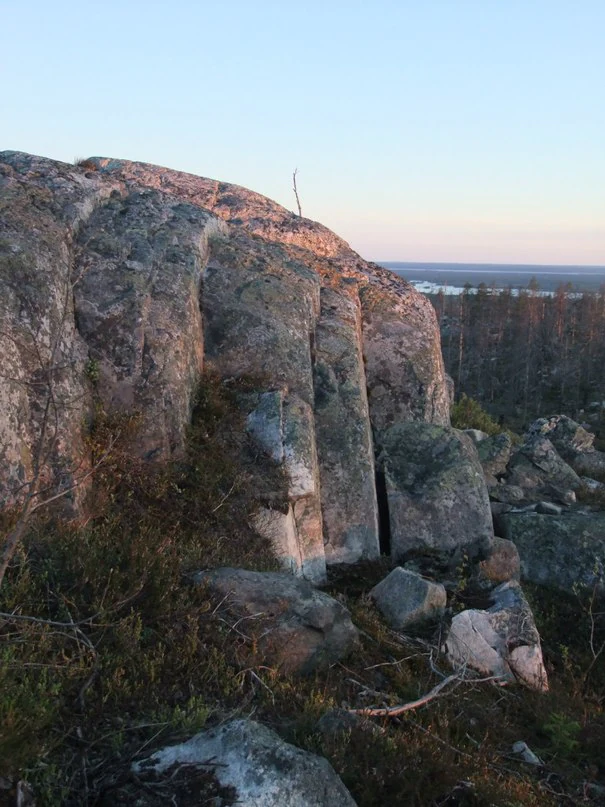
Vottovaara's defining landscape is a flat-topped rocky massif rising through the surrounding Karelian taiga, with summit elevations in the range of roughly 417 meters above sea level. The ridge is elongated in a roughly north-south direction for about 7 kilometers and forms the highest point of the West Karelian Upland, the broader highland belt that occupies western central Karelia.
The plateau surface is the most visually distinctive part of the mountain. Glacial action during the Pleistocene and the fractured quartzite bedrock together produced dense fields of large, rounded erratic boulders, scattered singly, stacked in groups, and in some cases leaning on smaller stones in seemingly precarious balances. Intermittently the boulders give way to exposed quartzite slabs, small boggy hollows, and thin pine-dominated woodland typical of subarctic upland settings. The surrounding lowlands descend into the lake-studded Karelian forest landscape, with nearby Segozero providing a major hydrological reference point.
Vottovaara ecosystems, habitats, and plant life
The natural environment around Vottovaara is characteristic of central Karelia: extensive boreal taiga dominated by pine and spruce, interspersed with mires, peatlands, and a dense network of lakes. The massif itself stands above this forest and wetland matrix as a rocky island, with thin, stony soils that support a sparse cover of low trees, lichens, and mosses rather than closed forest.
The broader protected territory, formalized in 2023 as Vottovaara National Park, adds lake and forest clusters to the core massif, including areas around Lake Pizanets and the forested landscape around Kiviyarvi and Pirolampi. These lake and woodland settings preserve the wider Karelian mosaic of upland taiga, paludified lowlands, and lake basins that is increasingly important as a reference for northern European taiga ecosystems.
Vottovaara conservation status and protection priorities
Vottovaara's modern conservation story is one of layered designations. In 2011, the Republic of Karelia declared the Vottovaara natural complex a landscape natural monument, giving formal protection to the mountain and an area of more than 1,500 hectares that includes surrounding terrain. The site was also added to Russia's federal register of cultural heritage objects, reflecting the combined natural and archaeological interest in the mountain.
In 2023, the Russian federal government elevated protection further by establishing Vottovaara National Park across parts of Muyezersky and Medvezhyegorsk districts. The national park encompasses three distinct clusters: the core rocky massif, the territory around Lake Pizanets, and the forested landscape around Kiviyarvi and Pirolampi. This larger framework positions Vottovaara as a long-term reference site for Karelian taiga, rocky upland, and lake basin ecosystems, alongside its role as a place of contested but persistent cultural significance.
Vottovaara cultural meaning and human context
Vottovaara carries a layered cultural meaning that extends well beyond its natural interest. The toponym itself is of Saami origin, combining a Saami stem associated with victory or overcoming with the word for mountain that is shared, in related forms, across Saami, Karelian, and Finnish languages.
The mountain has become a focal point of an ongoing debate about ancient Saami ritual activity. Early investigators argued that certain boulder arrangements on the plateau were cult structures associated with ancient Saami practice, an interpretation widely echoed in popular Russian-language sources. Mainstream archaeological assessment now treats most of these structures as natural formations or modern fabrications, while the cultural resonance of the site, including its appeal to mystical and quasi-scientific audiences, has nonetheless become a defining part of its modern identity.
Top sights and standout views in Vottovaara
Vottovaara's standout quality is the extraordinary surface of its plateau: a sweeping expanse of glacial erratics, balancing stones, and clustered boulders set on one of the highest points of the West Karelian Upland. This unusual geological stage is paired with the mountain's status as the highest point of its highland region and with a federal landscape natural monument designation that has now been broadened into a multi-cluster national park.
Equally distinctive is Vottovaara's cultural profile. The mountain sits at the intersection of serious geological observation, unresolved questions about ancient Saami presence, and a more recent wave of public interest that draws on folklore, fringe archaeology, and modern mysticism. Visitors encounter not just a Karelian mountain but a place where natural landscape and contested cultural meaning are unusually tightly bound together.
Best time to visit Vottovaara
The Karelian climate gives Vottovaara a short, mild summer and a long cold season dominated by snow. The most approachable window for general outdoor exploration is the snow-free period from late spring through early autumn, when daylight is longest and access roads and tracks are most practical. Snow cover transforms the plateau into a stark, frozen field of boulders and ice, which is visually striking but considerably more demanding for any on-foot visit. Given the remoteness of the massif and the high latitude of the site, visitors should generally expect cool conditions, changing weather, and a limited seasonal window for comfortable exploration.