Mori Atlas logo
Nature reserveŻerkowice-Skała

Examining the ecological boundaries and geologic terrain of the protected Izera Foothills geography

Żerkowice-Skała Nature Reserve: A Detailed Atlas of Sandstone Cuesta Landscapes in Lower Silesia

(Obszar mający znaczenie dla Wspólnoty Żerkowice-Skała)

Żerkowice-Skała represents a critical protected landscape within Poland, characterized by a distinct sandstone cuesta and outlier rock formations situated in the Pogórze Izerskie. This nature reserve, integral to the regional Natura 2000 network, offers an in-depth look at rare silicate cliff habitats and well-preserved deciduous forests. The site provides essential geographic context for understanding the Cretaceous sandstone exposures connected to the Bohemian Massif in southwestern Poland.

Natura 2000Site of Community Importancesandstone landscapeoutlier rockscuesta edgedeciduous forest

Żerkowice-Skała

Nature reserve

Park overview

Structured park overview, official facts, and landscape profile for Żerkowice-Skała

Żerkowice-Skała park facts, protected area profile, and essential visitor context

Review the core facts for Żerkowice-Skała, including designation, size, terrain, visitor scale, habitats, and operating context in one park-focused overview.

About Żerkowice-Skała

Żerkowice-Skała occupies a modest but ecologically rich corner of southwestern Poland, where the Izera Foothills give way to the characteristic sandstone landscape of northern Lower Silesia. The site straddles forested terrain between two small rural settlements, Żerkowice and Skała, in the commune of Lwówek Śląski. Together, these features anchor the area within a region widely appreciated for its combination of agricultural land use, scattered villages, and dramatic geological scenery.

The defining natural feature of the site is a sandstone cuesta edge studded with outlier rocks and rock exposures, surrounded by well-preserved deciduous forests. In the higher, drier positions these forests belong to the grąd type typical of central European conditions, including both the central European and subcontinental variants. Toward the Bóbr river valley, the vegetation shifts into elm-ash riparian forest, known in Polish as łęg, which thrives on the moister alluvial soils of the floodplain. The cliffs and rock faces themselves are classified as silicate cliff and scree habitats, adding geological diversity to the forest-dominated matrix.

Geologically, the sandstone outcrops here are notable for being among the northernmost exposures of Cretaceous sandstones linked to the Bohemian Massif. This places Żerkowice-Skała at a kind of ecological and geological frontier, where the sandstone landscapes that dominate further south thin out into isolated formations. Just to the north of the protected area, two large quarries continue to extract sandstone on an industrial scale, giving the site a striking contrast between active mineral extraction and small-scale conservation.

The site's identity in the Natura 2000 network is tied primarily to habitats and to the occurrence of Trichomanes speciosum. This fern favors permanently humid, shaded microclimates in rock crevices and protected overhangs, conditions the sandstone edge of Żerkowice-Skała supplies in abundance. The combination of suitable microclimate, mature deciduous forest cover, and the sheer physical structure of the sandstone outcrops creates conditions that are unusually favorable for the species at the level of its reference range.

Beyond the strictly ecological profile, the site also functions as a small node along regional hiking and landscape routes. The green trail connecting Bolesławiec with Lwówek Śląski runs through the area, and the surroundings include well-known rock formations such as Skała z Medalionem, Panieńskie Skały, and Skały Kawalerskie. These elements together place Żerkowice-Skała within the broader cultural-geographical identity of the Lwówek region, sometimes marketed regionally as Szwajcaria Lwówecka.

Quick facts and research context for Żerkowice-Skała

Żerkowice-Skała is a two-part Site of Community Importance established in 2011 under the Natura 2000 program. It covers roughly 84.85 hectares within the Izera Foothills mesoregion, in the district of Lwówek Śląski in Lower Silesian Voivodeship. The site is listed under the code PLH020077 and is classified as a proposed Special Area of Conservation focused on habitats rather than bird species.

Its conservation value rests on a combination of silicate sandstone cliffs and scree slopes on the one side, and on well-developed deciduous forest habitats on the other. The area lies near the northern extent of a series of Cretaceous sandstone outcrops connected to the Bohemian Massif, which gives the site a particular geological importance in the regional context.

Protection and recognition

Documented terrestrial protection history and Natura 2000 recognition records

Zerkowice-Skala Protection Status and International Recognition Data

Zerkowice-Skala maintains a documented terrestrial protection status established in the year 2011 alongside official Natura 2000 recognition records. Structured atlas profiles assemble designation history and management scope details to support conservation research.

International recognition

Protection details

Protection scope
Terrestrial
Designated year
2011
Transboundary protection
No
Park context

Deeper park guide and search-rich context for Żerkowice-Skała

Żerkowice-Skała history, landscape, wildlife, and travel context

Explore Żerkowice-Skała through its history, landscape character, ecosystems, wildlife, conservation priorities, cultural context, and seasonal travel timing in a structured park guide built for atlas discovery and search intent.

Why Żerkowice-Skała stands out

Żerkowice-Skała is best known as a reference site for the delicate filmy fern (Trichomanes speciosum), a rare and ecologically sensitive species whose strongholds in central Europe are closely tied to humid, shaded rock crevices. The area is also recognized for its outlier sandstone formations and its position as one of the northernmost Cretaceous sandstone exposures associated with the Bohemian Massif. Another defining trait of the site is the contrast between the dramatic sandstone rock edge with its cliffs and the well-preserved deciduous forest cover that surrounds it. This pairing of geological spectacle and old-growth forest habitat gives the site a distinctive character within the regional Natura 2000 network.
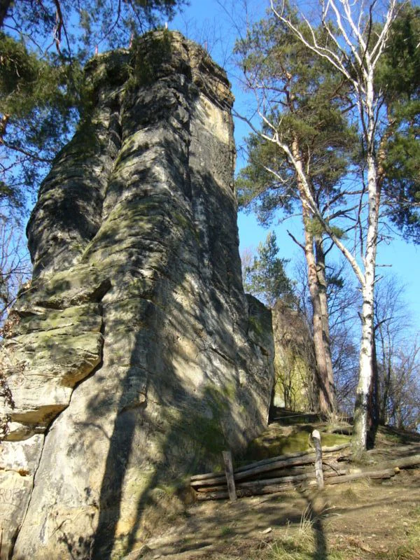
A tall, vertical sandstone rock formation rising above a forest floor with pine and birch trees.
A sandstone monadnock known as the Skała z medalionami in Żerkowice-Skała.

Żerkowice-Skała history and protected-area timeline

Żerkowice-Skała was formally designated in 2011 as a Site of Community Importance within Poland's Natura 2000 network. Its inclusion followed the recognition that the area combined several habitat types of European conservation interest together with reference populations of Trichomanes speciosum. The identification was driven by habitat-based criteria rather than bird protection, which shaped its later designation as a proposed Special Area of Conservation.

The site's contemporary context is shaped by centuries of human activity in the surrounding Bóbr valley settlements, including forestry, agriculture, and the long tradition of sandstone quarrying in the Izera Foothills. The presence of two large operating quarries immediately north of the protected area reflects an ongoing tension between mineral resource extraction and the protection of smaller, biologically valuable forest and rock sites.

Although the Natura 2000 designation is the most clearly documented formal step, the broader landscape of sandstone outliers and deciduous forests around Lwówek Śląski has long been recognized locally as a distinctive scenic and natural area, eventually grouped under the regional nickname of Szwajcaria Lwówecka.

Żerkowice-Skała landscape and geographic character

The landscape of Żerkowice-Skała is shaped by a sandstone cuesta whose edge rises above the surrounding terrain and is broken into a series of individual rock remnants, rocky outcrops, and small cliff faces. These geological features give the area its characteristic profile: a wooded highland edge occasionally punctuated by vertical sandstone walls and isolated standing rocks.

The sandstone belongs to the Cretaceous sequence associated with the Bohemian Massif, and the site lies at the northern tip of the broader band of such exposures that continues further south into the Sudetes foothills. This strategic position gives the area both its scenic character and a special place in regional geological understanding.

Around the rock edge, the terrain softens into the agricultural and village landscapes of the commune of Lwówek Śląski. Cultivated fields and the rural settlements of Żerkowice and Skała frame the protected area, while to the north the landscape changes abruptly into the operational landscape of two large sandstone quarries. This juxtaposition of small-scale habitats with intensive extraction is one of the most striking visual aspects of the site.

Żerkowice-Skała ecosystems, habitats, and plant life

The ecological character of Żerkowice-Skała arises from a tightly knit combination of forest, rock, and humidity-driven microhabitats. On the better-drained slopes and plateau positions, the vegetation consists of well-developed central European and subcontinental oak-hornbeam forests, known in Polish as grądy. These forests form the broad wooded matrix in which the sandstone rocks are embedded.

Where the terrain drops toward the Bóbr river valley, the vegetation shifts to elm-ash riparian forest, locally referred to as łęg wiązowo-jesionowy. These moister floodplain forests occupy the transition zone between the cuesta edge and the river system, contributing both habitat diversity and structural contrast along the slope gradient.

The rock faces and associated scree are themselves a specific habitat type within the site. Silicate cliff and scree habitats create the conditions for shade-loving, moisture-dependent species that would not survive in the surrounding forest interior. This combination of habitats, rather than any single forest type, is what gives Żerkowice-Skała its conservation profile.

Żerkowice-Skała wildlife and species highlights

The wildlife of Żerkowice-Skała is shaped less by charismatic large mammals and more by specialized habitat-dependent species tied to the sandstone rock crevices and old deciduous forest. The most prominent species is the delicate filmy fern, Trichomanes speciosum, for which the site is considered part of the reference range of high importance.

The fern benefits from the persistent humidity, deep shade, and sheltered microclimates found along the sandstone cliffs and under rock overhangs. Although it is a plant rather than an animal, it is often framed in conservation literature as a flagship species for the kind of small-scale, structurally complex habitat that the site protects. The site's mature deciduous forest also supports a broader community of woodland invertebrates, mosses, and bryophytes that respond to the same shaded, humid conditions.

Larger forest fauna typical of Lower Silesian deciduous woodlands is also expected to use the area, but the conservation emphasis of the site lies clearly with its habitat structures and the dependent specialist species rather than with game or large mammal populations.

Żerkowice-Skała conservation status and protection priorities

Żerkowice-Skała is a habitat-focused Natura 2000 site whose conservation importance is closely linked to its structural diversity and to the populations it supports of Trichomanes speciosum. The site's designation as a proposed Special Area of Conservation means that its primary role is to maintain, and where necessary improve, the conservation status of the listed habitat types rather than to serve primarily as a landscape-scale reserve.

The protected habitats include silicate cliff and scree environments, oak-hornbeam forests in their central European and subcontinental forms, and riparian elm-ash forests along the Bóbr valley. Maintaining these habitats simultaneously requires both preserving the local microclimate conditions in the rock crevices and maintaining the continuity and natural composition of the surrounding forest.

A particular conservation challenge lies in the proximity of two large sandstone quarries operating immediately north of the protected area. These operations influence hydrology, dust loads, and visual context, raising questions about how the sensitive microhabitats along the cliff edge can be preserved in the face of continuing industrial extraction of the same sandstone formation.

Żerkowice-Skała cultural meaning and human context

The cultural context of Żerkowice-Skała is rooted in the long pastoral and forestry traditions of the Bóbr river valley, where the villages of Żerkowice and Skała have shaped the land for centuries. The surrounding countryside is a mosaic of fields, meadows, orchards, and small woodland patches typical of historic Silesian rural landscapes.

Sandstone itself is deeply embedded in regional identity, both as a building material and as a raw material extracted from the quarries that still operate around Lwówek Śląski. The same geology that supports the protected habitats also provides the economic backbone of parts of the local economy, creating a layered relationship between landscape, heritage, and industry.

In regional tourism and cultural geography, the broader sandstone landscape is promoted under names such as Szwajcaria Lwówecka, and individual rock features like Skała z Medalionem, Panieńskie Skały, and Skały Kawalerskie have become local landmarks. Huzarski Skok, a historical cavalry event held in Żerkowice, adds another layer of cultural memory to the area. Together these features make the site part of a region where natural and cultural heritage are tightly intertwined.

Top sights and standout views in Żerkowice-Skała

Among the standout features of Żerkowice-Skała are the sandstone outlier rocks along the cuesta edge, the well-preserved deciduous forest cover, and the unusually favorable conditions for Trichomanes speciosum along the shaded cliff faces. The site also stands out for its position as one of the northernmost Cretaceous sandstone exposures linked to the Bohemian Massif, giving it a special geological significance in a regional context.

A further highlight is the site's role within the wider scenic landscape of the Lwówek region, where it sits alongside named rock formations and viewpoints that together form part of the identity of Szwajcaria Lwówecka. The green hiking trail passing through the area ties it into the broader recreational geography of Lower Silesia.

Best time to visit Żerkowice-Skała

Spring and early summer tend to bring out the freshness of the deciduous forest cover and make the sandstone outcrops easy to approach along forest paths, while the shaded conditions along the cliffs remain appealing through the warmer months. Autumn brings colorful foliage across the oak-hornbeam and riparian forests, contrasting sharply with the warm tones of the sandstone rocks themselves.

Mild, damp weather highlights the qualities that give the site its conservation significance, as humidity favors both the filmy fern and the broader community of moisture-loving plants and invertebrates along the rock faces. Very cold winter periods and heavy snow can make the rock edges and forest paths slippery, so winter visits require some caution while still offering a quieter perspective on the landscape.

Monthly climate preview

Long-term monthly temperature averages and precipitation data for Zerkowice-Skala

Zerkowice-Skala Climate Normals, Annual Temperature and Precipitation Patterns

Zerkowice-Skala exhibits a measured annual climate rhythm spanning freezing winter minimums to warm summer maximums alongside varying monthly precipitation rates. Analyzing the complete twelve-month temperature and precipitation dataset provides deeper insight into long-term atmospheric patterns.
Annual mean8 °C
-3 °C18 °C
Jan-3°
Feb-1°
Mar
Apr
May13°
Jun16°
Jul18°
Aug18°
Sep13°
Oct
Nov
Dec-1°
Warmest month
July

18.2 °C

Coolest month
January

-2.7 °C

Wettest month
July

3.2 mm/day

Driest month
April

1.4 mm/day

Park location guide

Geography guide, regional context, and park location map for Żerkowice-Skała

Żerkowice-Skała park geography, regions, and map view in Poland

Understand where Żerkowice-Skała sits in Poland through a broader geographic reading of the surrounding landscape, nearby location context, and its mapped position within the national park landscape.

How Żerkowice-Skała fits into Poland

Poland, officially the Republic of Poland, is a Central European country spanning from the Baltic Sea in the north to the Carpathian Mountains in the south. It borders Germany, Czech Republic, Slovakia, Ukraine, Belarus, Lithuania, and Kaliningrad Oblast. The country has a temperate climate, diverse landscapes, and is known for its rich history, cultural heritage, and strong economic position within the EU.

Wider geography shaping Żerkowice-Skała in Poland

Poland occupies 312,696 km2 in Central Europe, extending from the Baltic Sea coast in the north to the Sudetes and Carpathian Mountains in the south. It borders Germany to the west, Czech Republic and Slovakia to the south, Ukraine and Belarus to the east, and Lithuania and Kaliningrad Oblast to the northeast. The landscape includes lowland plains, uplands, and mountain ranges.

Map view of Żerkowice-Skała

Use this park location map to pinpoint Żerkowice-Skała in Poland, understand its exact geographic position, and read its mapped placement within the surrounding landscape more clearly.

Pigeon | © OpenStreetMap contributors

Location context for Żerkowice-Skała

Lower Silesian Voivodeship
Recorded earthquake history

Examine the Seismic History and Earthquake Records for Żerkowice-Skała

Browse the documented seismic history for the Żerkowice-Skała nature reserve to understand regional earthquake records. MoriAtlas provides a clear view of associated event data and epicentre distances to assist in geographical exploration of this unique sandstone site in Lower Silesia.

Żerkowice-Skała Earthquake History

Catalogued events

678 events

Strongest magnitude

Magnitude 5

Most recent event

Jul 18, 2026

This history includes earthquakes recorded inside the park or within 50 km of its borders

Visual reference guide to sandstone rock formations and forest habitats

Żerkowice-Skała Photos and Protected Area Landscape Scenery

Visual documentation captures the dramatic sandstone cuestas, rocky outcrops, and deciduous forest cover defining Żerkowice-Skała. Detailed photography reveals the unique topography and rare habitat features characterizing this protected region in southwestern Poland.

A tall, vertical sandstone rock formation rising above a forest floor with pine and birch trees.

Park atlas

Discover adjacent sandstone landscapes and protected habitats across Lower Silesia

Other Protected Areas and Parks Near Żerkowice-Skała for Regional Comparison

Browse nearby protected areas and regional parks connected by shared sandstone geology and forested foothill terrain. Comparing these adjacent natural sites reveals the wider ecological patterns defining southwestern Poland.
A soft watercolor painting of a river flowing through a hilly, forested landscape with light green and pastel tones.
Nature reserveLower Silesian Voivodeship
3.1 km away#1 closest

Southeast

Ostoja nad Bobrem Nature Reserve and Bóbr River Valley Geographic Atlas

Protected Sudetes foothills landscape in Poland

Ostoja nad Bobrem represents a significant protected area within the Lower Silesian Voivodeship, characterized by its winding river corridor and hilly topography. The reserve supports a range of habitats including rare orchid-rich grasslands and dense slope forests. This atlas entry provides a detailed look at the geographic distribution and ecological importance of this essential Polish nature reserve.

Area
153.73 km²
Established
2009
Relief
Upland
Climate
Temperate
Protected landscapeLower Silesian Voivodeship
25 km away#2 closest

East

Park Krajobrazowy Chełmy: Protected Landscape and Volcanic Geography in Southwestern Poland

Geological atlas of the Kaczawskie Foothills

Deep dive into the complex terrain of Park Krajobrazowy Chełmy, a protected area in Lower Silesia renowned for its layered volcanic history and unique floristic composition. This site showcases an intricate network of ravines and basalt-crowned hills that define the edge of the Sudetes, offering a comprehensive look at the region's ancient geological development and ecological heritage.

Area
159.91 km²
Established
1992
Relief
Mountain
Climate
Temperate
Nature reserveLower Silesian Voivodeship
About 34 km away#3 closest

Southeast

Rezerwat przyrody Mszana i Obłoga: Geological and Forest Protected Area Overview

Volcanic terrain in the Lower Silesian Voivodeship

This nature reserve preserves the natural maple-lime and oak-hornbeam forest communities found on the slopes of the Mszana and Obłoga hills. The area is defined by its striking basalt outcrops and volcanic rubble fields, providing a unique ecological character within the broader Kaczawskie foothills of southwestern Poland.

Area
0.999 km²
Established
2015
Relief
Mountain
Climate
Temperate
Watercolor illustration of a mountain range with green hills, pink and yellow sky, and sparse vegetation
National parkPoland
34 km away#4 closest

South

Karkonosze National Park: A Premier National Park in Poland's Giant Mountains

Discover alpine terrain and unique glacial landscapes.

Karkonosze National Park is a significant protected area in Poland, renowned for its dramatic alpine topography carved by ancient glaciers. As the highest range in the Polish Sudetes, it features striking U-shaped valleys, U-shaped glacial cirques, and diverse subalpine to alpine ecosystems. This national park provides a rich context for understanding Central European mountain geography and exploring its mapped protected boundaries.

IUCN
II
Relief
Mountain
Scope
Terrestrial
A minimalist watercolor illustration depicting rolling, layered mountain ridges in soft shades of green, yellow, and light pink against a white background.
National parkDolnośląskie Voivodeship
34 km away#5 closest

South

Karkonoski Park Narodowy: Mapping Protected Granite Peaks and Glacial Terrain in Poland

High-mountain landscapes in the Dolnośląskie Voivodeship

Trace the diverse geography of Karkonoski Park Narodowy, where granite blockfields and glacial cirques define the high-altitude terrain. This protected area represents one of Central Europe's most significant upland ecosystems, showcasing a vertical transition from dense forest to alpine tundra.

Area
59.51 km²
Established
1959
Visitors
2M annual
Relief
Mountain
Protected areaLower Silesian Voivodeship
36 km away#6 closest

Southeast

Trzcińskie Mokradła Protected Area: Geographic Overview and Mapped Sudeten Wetland Landscape

Located in the Lower Silesian Voivodeship of Poland

Trzcińskie Mokradła stands as a significant mire complex in the Jelenia Góra Basin, providing a rare look at peat-forming habitats in the Sudetes. This protected area offers deep insight into regional wetland conservation and the environmental history of southwestern Poland, serving as an essential reference for researchers and landscape enthusiasts interested in intramontane basin geography.

Area
0.753 km²
Established
2011
Scope
Terrestrial
Water
Major water bodies
Watercolor painting showing green forests, a valley, and distant mountains under a soft sky
National parkLiberec Region
40 km away#7 closest

South

Krkonoše National Park: Central European Alpine Protected Area and Map Context

Discover glacial landforms and unique ecosystems in the Giant Mountains.

Krkonoše National Park, situated in the Liberec Region, is a premier example of a protected alpine landscape in Central Europe. This page facilitates exploration of its significant glacial geography, including distinct cirques, rockfields, and valleys, providing vital context for understanding its protected area status. Engage with the mapped terrain and discover the unique ecological features that make this national park a cornerstone of conservation and geographic study within the Czech Republic.

Area
363.52 km²
Established
1963
IUCN
II
Visitors
12.1M annual
Natural monumentLiberecký kraj
About 42 km away#8 closest

Southwest

Vlčí louka Natural Monument: Protected Bog Landscape in the Liberecký kraj Region

High-elevation peatland and mountain habitat geography

Vlčí louka serves as a prime example of a high-altitude raised bog located along the Smědavská hora ridge. This protected area supports a diverse suite of peatland plants and serves as a vital refuge for mountain birds. By studying its unique terrain, mapped boundaries, and position within the Jizera Mountains, users gain a deeper understanding of this specialized, elevated ecosystem in the Czech Republic.

Area
0.08 km²
Established
1965
IUCN
IV
Relief
Highland

Common questions about visiting, size, designation, and location context for Żerkowice-Skała

Żerkowice-Skała FAQs for park facts, access, geography, and protected area context

Find quick answers about Żerkowice-Skała, including protected-area facts, park geography, trail and visitor context, and how the park fits into its surrounding country and regional landscape.
MoriAtlas Explorer

Continue Your Protected Areas Search Across the Global Atlas

Deepen your exploration by continuing the structured search for national parks and protected areas worldwide. Utilize the comprehensive filtering capabilities to compare different conservation landscapes and refine your understanding of global park geography. Discover more about the distribution and characteristics of protected natural areas.

Global natural geography