
Mori Atlas logo
Nature reserveOstoja nad Bobrem

Analyzing the Bóbr River valley ecological corridors, hillside forest habitats, and Sudetes terrain

Ostoja nad Bobrem Nature Reserve: Mapped Protected Landscapes in the Lower Silesian Voivodeship

(Ostoja nad Bobrem (PLH020054))

Ostoja nad Bobrem serves as a vital ecological corridor within the Lower Silesian Voivodeship of southwestern Poland, stretching along the Bóbr River valley. This protected nature reserve encompasses a diverse mosaic of riparian woodlands, xerothermic grasslands, and priority slope forests built upon a unique geological mix of basalts, limestones, and sandstones. The area functions as a critical link between the Odra river system and the mountainous terrain of the Sudetes, supporting regional landscape connectivity.

Natura 2000river valleySudetes foothillsPogórze Izerskiehabitat protectiondeciduous forests
Stylized vector illustration of a central waterfall flowing into a river, surrounded by pine forests, steep cliffs, and soft pink and yellow clouds.

Ostoja nad Bobrem

Nature reserve

Park overview

Structured park overview, official facts, and landscape profile for Ostoja nad Bobrem

Ostoja nad Bobrem park facts, protected area profile, and essential visitor context

Review the core facts for Ostoja nad Bobrem, including designation, size, terrain, visitor scale, habitats, and operating context in one park-focused overview.

About Ostoja nad Bobrem

Ostoja nad Bobrem is a substantial protected landscape in the Lower Silesian Voivodeship of southwestern Poland, defined by the valley of the Bóbr River and the surrounding slopes of the Pogórze Izerskie. Officially designated under the EU Natura 2000 network with the code PLH020054, it occupies a transitional zone between the lowlands connected to the Odra system and the higher Sudetes mountains further south. The site extends roughly from Siedlęcin north of Jelenia Góra westwards to Wleń, embracing both the river corridor itself and the wooded or grass-covered hills that frame it.

The area is deeply rooted in Polish and Central European conservation planning. It was first proposed by the European Commission in February 2009 as a Site of Community Importance under the EU Habitats Directive, then was confirmed in Polish law in August 2022 through a formal designation that brought the area into the national Natura 2000 framework. This two-stage history, first EU-level recognition and later formal national status, reflects a typical pattern for European habitat-focused protected areas where safeguarding rare habitats and species of community interest is the main protection objective.

Ecologically, Ostoja nad Bobrem stands out for the unusual concentration of habitat types packed into a relatively compact area. The underlying geology is geologically diverse, with basalts, limestones, and sandstones creating contrasting soil conditions and microhabitats. This geological variety, combined with the river, valleys, and hill slopes, supports an exceptionally diverse mosaic of meadows, pastures, forests, and rocky habitats. The site contains at least 13 natural habitat types from Annex I of the EU Habitats Directive, ranging from priority habitats such as slope oak-hornbeam forests (Aceri-Tilietum) and orchid-rich xerothermic grasslands to more widespread communities such as alluvial willow and alder forests, mountain hay meadows, and rheophilous gallery forests.

The site's importance is not only local. By preserving a continuous and relatively natural corridor along the Bóbr valley and the surrounding ridges, Ostoja nad Bobrem provides a key ecological link between the Odra basin and the major Sudetes massifs of Karkonosze and Rudawy Janowickie. Maintaining the integrity of this corridor is considered essential to the coherence of the Natura 2000 network in Lower Silesia, allowing species movement, seasonal migration, and recolonization across a heavily human-modified region.

Surrounding the protected area itself, towns such as Wleń, Lwówek Śląski, and Jelenia Góra add considerable cultural depth. Wleń, located centrally within the protected zone, is regarded as one of the oldest and most picturesquely situated small towns of Lower Silesia, with the Zamkowa Hill nature reserve and the ruins of a medieval Piast-era castle. Various long-distance hiking routes cross the area, including the Trail of Extinct Volcanoes, the international E3 long-distance footpath, and the Piast Castles Trail, making the site a meeting point between ecological protection and cultural tourism in the Sudetes foothills.

Quick facts and research context for Ostoja nad Bobrem

Ostoja nad Bobrem is a habitat-oriented Natura 2000 site, first proposed by the European Commission in February 2009 and formally confirmed under Polish law in August 2022. It lies in Lower Silesian Voivodeship within the Pogórze Izerskie mesoregion and spans several municipalities including Jeżów Sudecki, Lubomierz, Lwówek Śląski, Stara Kamienica, and Wleń.

The protected area covers roughly 15,373 hectares of river valley, foothills, and adjacent uplands and is identified by the EU site code PLH020054. It preserves at least 13 natural habitat types from Annex I of the EU Habitats Directive and supports 11 species listed under Annex II, including notable bats, amphibians, fish, and butterflies. The site also serves as an ecological corridor between the Odra valley and the higher Sudetes massifs of Karkonosze and Rudawy Janowickie.

Protection and recognition

Documented terrestrial designation history and Natura 2000 records

Ostoja nad Bobrem Protection Status and International Recognition

Ostoja nad Bobrem maintains terrestrial protected area status established in the year 2022. Official records outline designated management scope alongside imported Natura 2000 recognition sources.

International recognition

Protection details

Protection scope
Terrestrial
Designated year
2022
Transboundary protection
No
Park context

Deeper park guide and search-rich context for Ostoja nad Bobrem

Ostoja nad Bobrem history, landscape, wildlife, and travel context

Explore Ostoja nad Bobrem through its history, landscape character, ecosystems, wildlife, conservation priorities, cultural context, and seasonal travel timing in a structured park guide built for atlas discovery and search intent.

Why Ostoja nad Bobrem stands out

Ostoja nad Bobrem is best known for protecting one of the largest priority slope forest communities of Aceri-Tilietum in Poland, for hosting rich xerothermic grasslands with significant orchid populations, and for being a key bat conservation area in Lower Silesia. The site is also recognized for its ecological role as a wildlife corridor that links the larger Sudetes uplands to the broader Odra basin, while preserving surprisingly varied geology, with basalts, limestones, and sandstones shaping hills rising above the Bóbr River valley.
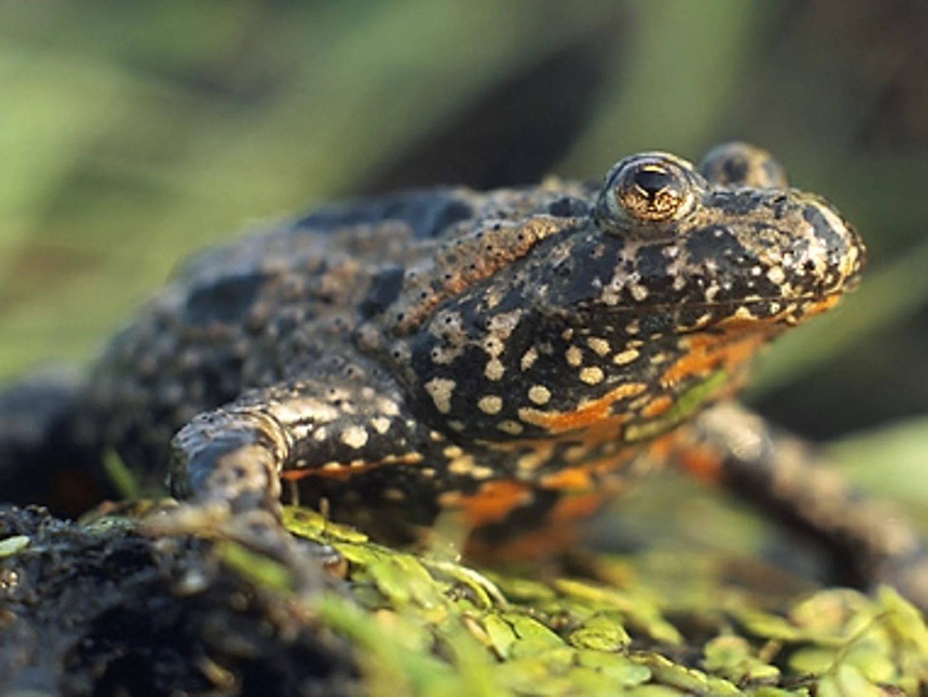
A close up, eye level photograph of a European fire-bellied toad sitting on low, green aquatic vegetation, showing its warty, dark-spotted skin and hints of orange on its underside.
A close up view of a European fire-bellied toad, a species found in the wetlands of Ostoja nad Bobrem.

Ostoja nad Bobrem history and protected-area timeline

Ostoja nad Bobrem's history as a protected area begins in the European Union's Natura 2000 ecological network. The site was first submitted to the European Commission as a candidate Site of Community Importance and was formally adopted on 13 February 2009 under the EU Habitats Directive. This stage marked the international recognition of the Bóbr valley and its adjoining hills as a habitat area of pan-European interest.

For more than a decade after its EU-level listing, the site existed within the Natura 2000 framework but lacked full national legal documentation under Polish conservation law. This changed on 11 August 2022, when Poland officially confirmed the special area of conservation through a dedicated legal act (Dz.U. 2022 poz. 1568), assigning the area the official designation PLH020054 and binding its protection into Polish national nature conservation legislation.

The longer human history of the region stretches well beyond protected-area status. Wleń and surrounding settlements have medieval origins, and the landscape carries traces of Piast-era castles, historic grodziska (fortified settlement sites), and centuries of agricultural use. These cultural layers are part of why the area today balances active conservation with tourism and traditional land use.

Ostoja nad Bobrem landscape and geographic character

The landscape of Ostoja nad Bobrem is shaped by the Bóbr River and the neighboring uplands of the Pogórze Izerskie, in the northern foothills of the Sudetes. The Bóbr valley forms the central axis of the area, with the river carving between hills that rise in a patchwork of ridges, slopes, and small valleys. The Pilchowickie Lake, an artificial reservoir on the Bóbr, forms one of the recognizable scenic features of the lower part of the valley.

Geologically, the area is unusually varied for a single protected site. The hills framing the river include exposures and outcrops of basalt, limestone, and sandstone, giving rise to different soils, slope angles, and microclimates. This geological diversity drives much of the ecological richness of the area. In places, weathered volcanic and sedimentary rocks produce warm, dry slopes ideal for thermophilic vegetation, while the riverbanks and ravines support floodplain and gallery forest communities.

The resulting scenery is a mix of forested hills, semi-natural grasslands, rocky escarpments, narrow river bends, and reservoir-fringed open water. The landscape visually links the cultivated surroundings of the Lower Silesian towns with the more rugged, forested terrain of the higher Sudetes mountains to the south.
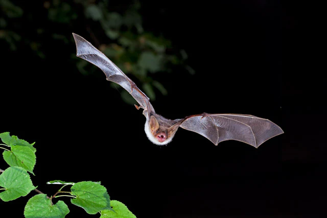
A greater mouse-eared bat flying against a black background with a small cluster of green leaves in the lower left corner.
A greater mouse-eared bat in flight, a key species protected within Ostoja nad Bobrem.

Ostoja nad Bobrem ecosystems, habitats, and plant life

Ecologically, Ostoja nad Bobrem represents a remarkably concentrated mosaic of habitat types. The site contains at least 13 natural habitat types listed under Annex I of the EU Habitats Directive, ranging from priority habitats of European significance to more widespread, but ecologically valuable, forest, meadow, and riverine communities.

The dominant land cover consists of meadows, pastures, and forests, reflecting the long agricultural and forestry history of the region. Among the most ecologically significant habitats are slope oak-hornbeam forests of the Aceri-Tilietum type, of which the area holds one of the largest known stands in Poland. Equally important are the xerothermic grasslands, dry, sun-exposed slopes harboring thermophilic plant communities with a notable proportion of wild orchids, making these habitats a priority for European conservation.

Along the Bóbr River and its tributaries, the area preserves a range of riparian and floodplain habitats. These include willow, alder, poplar, and ash floodplain forests, shifting pioneer vegetation on river gravels and stones, and wet meadows such as the moisture-variable Molinion grasslands. Upland forests are represented by acidic and fertile beech woodlands as well as sycamore and small-leaved lime forests of the Tilio-Acerion type, and tall-herb subalpine communities characteristic of montane river margins.

Together, these habitats form a layered ecological system where river habitats, mixed deciduous forests, dry grasslands, and montane forests coexist within a relatively compact geographic envelope.
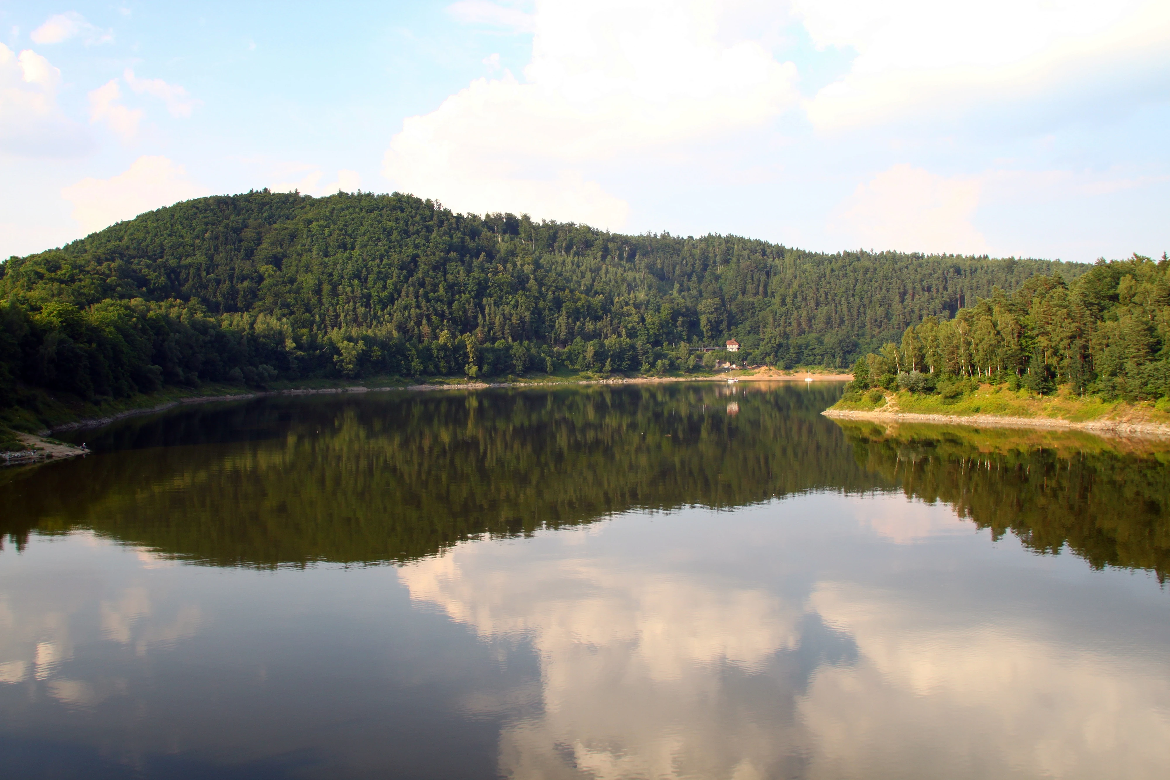
A wide, calm river or reservoir reflecting a bright, cloudy sky and dense, green forested hills on its banks.
A calm view of the reservoir within the Bober Valley, reflecting the surrounding forested hills.

Ostoja nad Bobrem wildlife and species highlights

The wildlife of Ostoja nad Bobrem reflects the diversity of its habitats, with a particular focus on species protected under Annex II of the EU Habitats Directive. The area supports eleven such species, spanning mammals, amphibians, fish, and invertebrates, each tied to specific habitat conditions within the site.

Bats are among the most ecologically significant animal groups. The site is notable for holding what is believed to be the largest known breeding colony of the greater mouse-eared bat (Myotis myotis) in Lower Silesia, located in the church in Wleń. The barbastelle bat (Barbastella barbastellus) is also recorded. These bat populations tie the conservation importance of the area closely to its old buildings, caves, and mature forests.

Amphibians are represented by the great crested newt (Triturus cristatus) and the fire-bellied toad (Bombina bombina), both species sensitive to water quality and habitat continuity. The river and stream systems support specialized fish, including the bullhead (Cottus gobio), the European brook lamprey (Lampetra planeri), the bitterling (Rhodeus sericeus), and the weatherfish (Misgurnus fossilis), all of which require clean, well-oxygenated water and intact riverbeds.

Invertebrate diversity is equally notable. The area hosts several species of conservation interest, including the dusky large blue (Phengaris nausithous), the scarce large blue (Phengaris teleius), and the large copper (Lycaena dispar), butterflies that depend on very specific combinations of meadow vegetation and host plants. The presence of these species underscores the value of the area's mosaic of moist meadows, wet grasslands, and water margins.
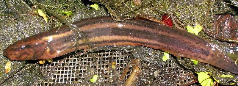
A weather loach fish with a long, brown, striped body resting in shallow water among vegetation and a wire mesh.
A weather loach (Misgurnus fossilis), a species protected within the Ostoja nad Bobrem area.

Ostoja nad Bobrem conservation status and protection priorities

The conservation value of Ostoja nad Bobrem lies in the combination of habitat richness, species of European interest, and strategic geographic position. Designated under the EU Habitats Directive as a Site of Community Importance and confirmed nationally as a Polish special area of conservation, the site is intended to safeguard a defined set of habitats and species of community importance in the long term.

Its particular strength is the concentration of priority habitats. The slope oak-hornbeam forests (Aceri-Tilietum) and the orchid-rich xerothermic grasslands are recognized as priority habitats under the directive, making their protection a matter of European-level importance. The presence of eleven Annex II species further underscores the conservation profile of the site.

Equally important is the site's ecological connectivity. By preserving a natural corridor along the Bóbr valley, Ostoja nad Bobrem links the wider Odra river system to the higher mountain ranges of Karkonosze and Rudawy Janowickie, supporting landscape-level processes such as species dispersal, seasonal migration, and recolonization. Maintaining this corridor function is integral to the coherence of the Natura 2000 network in the Sudetes region.

Conservation management aims to reduce a range of identified pressures, including water and air pollution, illegal waste disposal, intensification of agriculture and forestry, river regulation, and disturbance of bat hibernation sites. Protecting habitat integrity and water quality is central to maintaining the site's overall conservation value.

Ostoja nad Bobrem cultural meaning and human context

The cultural context of Ostoja nad Bobrem is closely tied to the historic towns and landscapes of the Lower Silesian Sudetes foothills. Wleń, situated in the central part of the protected area, is regarded as one of the oldest small towns in Lower Silesia and is renowned for its scenic setting, characterized by the Zamkowa Hill nature reserve and the visible ruins of a medieval castle dating back to the Piast dynasty.

The broader region carries a deep human-history imprint, including medieval grodziska (fortified settlement sites), castles, wayside shrines, and a long tradition of agriculture. Several long-distance hiking routes pass through or near the area, including the Trail of Extinct Volcanoes, the international E3 long-distance footpath, and the Piast Castles Trail, which together link the ecological and cultural heritage of the region.

Tourism in and around the protected area combines walking, cycling, agrotourism, and water-based recreation, drawing on the scenic variety of the river valley and the cultural landmarks of surrounding towns such as Jelenia Góra, Wleń, and Lwówek Śląski.

Top sights and standout views in Ostoja nad Bobrem

Among the strongest points of distinction of Ostoja nad Bobrem are its ecologically diverse Sudetes foothills setting, the unusual concentration of priority habitats, and its function as a key ecological corridor in Lower Silesia. The site combines rocky slopes, river floodplains, meadows, and forests within a single coherent protected area.

A defining feature is its orchid-rich xerothermic grasslands, its nationally important colonies of greater mouse-eared bats, and its mosaic of deciduous forests ranging from hillside oak-hornbeam woodlands to floodplain willow and alder galleries. Together with the surrounding medieval towns and long-distance hiking routes, these features make the area both an ecological stronghold and a culturally rich part of the Polish Sudetes.

Best time to visit Ostoja nad Bobrem

As a habitat-oriented protected area rather than a developed visitor destination, Ostoja nad Bobrem is best appreciated during the warmer months when plant communities are in full display. Late spring and early summer are particularly favorable for seeing the orchid-rich xerothermic grasslands come into bloom, while the broader vegetative season offers the richest experience of meadow, forest, and river habitats.

Late summer and early autumn bring forest color and generally stable weather for exploring the Bóbr valley and the surrounding hills, especially for those combining the visit with hiking routes such as the Piast Castles Trail or the Trail of Extinct Volcanoes. Winter visits can offer quieter wildlife observation possibilities, particularly for bats and forest species, though access conditions in the hills and along the river should be considered. Overall, the area rewards visits focused on landscape, ecology, and cultural heritage rather than seasonal tourist programming.


Monthly climate preview

Long-term representative monthly temperature averages and precipitation totals for Ostoja nad Bobrem

Ostoja nad Bobrem Climate Normals and Measured Annual Temperature and Precipitation Rhythm

Ostoja nad Bobrem exhibits a measured annual rhythm ranging from sub-zero winter minimums to warm summer maximums alongside consistent monthly precipitation. Evaluating the complete twelve-month temperature and precipitation dataset provides deeper context for long-term regional climatology.
Annual mean8 °C
-3 °C18 °C
Jan-3°
Feb-1°
Mar
Apr
May13°
Jun16°
Jul18°
Aug18°
Sep13°
Oct
Nov
Dec-1°
Warmest month
July

18.2 °C

Coolest month
January

-2.7 °C

Wettest month
July

3.2 mm/day

Driest month
April

1.4 mm/day

Park location guide

Geography guide, regional context, and park location map for Ostoja nad Bobrem

Ostoja nad Bobrem park geography, regions, and map view in Poland

Understand where Ostoja nad Bobrem sits in Poland through a broader geographic reading of the surrounding landscape, nearby location context, and its mapped position within the national park landscape.

How Ostoja nad Bobrem fits into Poland

Poland, officially the Republic of Poland, is a Central European country spanning from the Baltic Sea in the north to the Carpathian Mountains in the south. It borders Germany, Czech Republic, Slovakia, Ukraine, Belarus, Lithuania, and Kaliningrad Oblast. The country has a temperate climate, diverse landscapes, and is known for its rich history, cultural heritage, and strong economic position within the EU.

Wider geography shaping Ostoja nad Bobrem in Poland

Poland occupies 312,696 km2 in Central Europe, extending from the Baltic Sea coast in the north to the Sudetes and Carpathian Mountains in the south. It borders Germany to the west, Czech Republic and Slovakia to the south, Ukraine and Belarus to the east, and Lithuania and Kaliningrad Oblast to the northeast. The landscape includes lowland plains, uplands, and mountain ranges.

Map view of Ostoja nad Bobrem

Use this park location map to pinpoint Ostoja nad Bobrem in Poland, understand its exact geographic position, and read its mapped placement within the surrounding landscape more clearly.

Pigeon | © OpenStreetMap contributors

Location context for Ostoja nad Bobrem

Lower Silesian Voivodeship
Recorded earthquake history

Review the Historical Earthquake Catalogue for Ostoja nad Bobrem

MoriAtlas maintains a comprehensive historical record of seismic activity associated with the Ostoja nad Bobrem nature reserve. Consult this catalogue to view documented events, event magnitudes, and epicentre distances relevant to the Bóbr River valley and its surrounding foothills.

Ostoja nad Bobrem Earthquake History

Catalogued events

685 events

Strongest magnitude

Magnitude 5

Most recent event

Jul 18, 2026

This history includes earthquakes recorded inside the park or within 50 km of its borders

Visualizing the river valley, slope forests, and protected habitats of the Sudetes foothills

Ostoja nad Bobrem Photos and Landscape Scenery

Examinations of Ostoja nad Bobrem reveal diverse terrain ranging from basalt outcrops to riverine woodlands along the Bóbr valley. Visualizing these protected habitats provides essential context for understanding regional ecology and landscape connectivity across southwestern Poland.

A close up, eye level photograph of a European fire-bellied toad sitting on low, green aquatic vegetation, showing its warty, dark-spotted skin and hints of orange on its underside.

A close-up shot of a bat flying inside a dark, rocky cave with its wings fully extended.

A greater mouse-eared bat flying against a black background with a small cluster of green leaves in the lower left corner.

A wide, calm river or reservoir reflecting a bright, cloudy sky and dense, green forested hills on its banks.

A weather loach fish with a long, brown, striped body resting in shallow water among vegetation and a wire mesh.

A wide view of a dry, golden-brown meadow with tall grasses in the foreground, bordering a dense line of green deciduous forest in the background.

Park atlas

Compare regional river valleys, foothill habitats, and neighboring conservation landscapes

Parks Near Ostoja nad Bobrem and Surrounding Protected Natural Areas

Visitors exploring Ostoja nad Bobrem can continue comparing nearby national parks and protected areas across the surrounding Sudetes foothills. Expanding the geographic scope reveals connected wildlife corridors and varied regional terrain.
Nature reserveLower Silesian Voivodeship
3.1 km away#1 closest

Northwest

Żerkowice-Skała Nature Reserve: Mapped Sandstone Cuestas and Forest Habitats in Lower Silesia

A study of Cretaceous geology and protected forest landscapes in Poland

Żerkowice-Skała offers a window into the geological complexity of the Pogórze Izerskie. This nature reserve protects a vital sandstone cuesta edge, creating a mosaic of cliff habitats and old-growth deciduous forest communities. As a key Natura 2000 site, it serves as a crucial reference point for understanding the distribution of rare species and the northernmost Cretaceous exposures linked to the broader Bohemian Massif region.

Area
0.849 km²
Established
2011
Relief
Upland
Climate
Temperate
A minimalist watercolor illustration depicting rolling, layered mountain ridges in soft shades of green, yellow, and light pink against a white background.
National parkDolnośląskie Voivodeship
10 km away#2 closest

South

Karkonoski Park Narodowy: Mapping Protected Granite Peaks and Glacial Terrain in Poland

High-mountain landscapes in the Dolnośląskie Voivodeship

Trace the diverse geography of Karkonoski Park Narodowy, where granite blockfields and glacial cirques define the high-altitude terrain. This protected area represents one of Central Europe's most significant upland ecosystems, showcasing a vertical transition from dense forest to alpine tundra.

Area
59.51 km²
Established
1959
Visitors
2M annual
Relief
Mountain
Protected landscapeLower Silesian Voivodeship
11 km away#3 closest

East

Park Krajobrazowy Chełmy: Protected Landscape and Volcanic Geography in Southwestern Poland

Geological atlas of the Kaczawskie Foothills

Deep dive into the complex terrain of Park Krajobrazowy Chełmy, a protected area in Lower Silesia renowned for its layered volcanic history and unique floristic composition. This site showcases an intricate network of ravines and basalt-crowned hills that define the edge of the Sudetes, offering a comprehensive look at the region's ancient geological development and ecological heritage.

Area
159.91 km²
Established
1992
Relief
Mountain
Climate
Temperate
Watercolor illustration of a mountain range with green hills, pink and yellow sky, and sparse vegetation
National parkPoland
11 km away#4 closest

South

Karkonosze National Park: A Premier National Park in Poland's Giant Mountains

Discover alpine terrain and unique glacial landscapes.

Karkonosze National Park is a significant protected area in Poland, renowned for its dramatic alpine topography carved by ancient glaciers. As the highest range in the Polish Sudetes, it features striking U-shaped valleys, U-shaped glacial cirques, and diverse subalpine to alpine ecosystems. This national park provides a rich context for understanding Central European mountain geography and exploring its mapped protected boundaries.

IUCN
II
Relief
Mountain
Scope
Terrestrial
Protected areaLower Silesian Voivodeship
16 km away#5 closest

Southeast

Trzcińskie Mokradła Protected Area: Geographic Overview and Mapped Sudeten Wetland Landscape

Located in the Lower Silesian Voivodeship of Poland

Trzcińskie Mokradła stands as a significant mire complex in the Jelenia Góra Basin, providing a rare look at peat-forming habitats in the Sudetes. This protected area offers deep insight into regional wetland conservation and the environmental history of southwestern Poland, serving as an essential reference for researchers and landscape enthusiasts interested in intramontane basin geography.

Area
0.753 km²
Established
2011
Scope
Terrestrial
Water
Major water bodies
Watercolor painting showing green forests, a valley, and distant mountains under a soft sky
National parkLiberec Region
18 km away#6 closest

South

Krkonoše National Park: Central European Alpine Protected Area and Map Context

Discover glacial landforms and unique ecosystems in the Giant Mountains.

Krkonoše National Park, situated in the Liberec Region, is a premier example of a protected alpine landscape in Central Europe. This page facilitates exploration of its significant glacial geography, including distinct cirques, rockfields, and valleys, providing vital context for understanding its protected area status. Engage with the mapped terrain and discover the unique ecological features that make this national park a cornerstone of conservation and geographic study within the Czech Republic.

Area
363.52 km²
Established
1963
IUCN
II
Visitors
12.1M annual
Nature reserveLower Silesian Voivodeship
About 19 km away#7 closest

East

Rezerwat przyrody Mszana i Obłoga: Geological and Forest Protected Area Overview

Volcanic terrain in the Lower Silesian Voivodeship

This nature reserve preserves the natural maple-lime and oak-hornbeam forest communities found on the slopes of the Mszana and Obłoga hills. The area is defined by its striking basalt outcrops and volcanic rubble fields, providing a unique ecological character within the broader Kaczawskie foothills of southwestern Poland.

Area
0.999 km²
Established
2015
Relief
Mountain
Climate
Temperate
Watercolor painting of a mountain range with spruce forest in the foreground on a white background.
Nature reserveLiberec Region
About 26 km away#8 closest

Southwest

Prales Jizera Nature Reserve: Protected Mountain Geography and Summit Landscapes

Highland spruce forests and granite outcrops in the Liberec Region

Investigate the summit geomorphology of Prales Jizera, a vital protected area encompassing rare climax spruce forest and granite blockfields. This record provides detailed geographic context on the reserve's unique soil, hydrological watershed position, and its role as a landmark conservation site in the Jizera Mountains.

Area
0.936 km²
Established
1960
IUCN
IV
Relief
Mountain

Common questions about visiting, size, designation, and location context for Ostoja nad Bobrem

Ostoja nad Bobrem FAQs for park facts, access, geography, and protected area context

Find quick answers about Ostoja nad Bobrem, including protected-area facts, park geography, trail and visitor context, and how the park fits into its surrounding country and regional landscape.
MoriAtlas Explorer

Continue Your Protected Areas Search Across the Global Atlas

Deepen your exploration by continuing the structured search for national parks and protected areas worldwide. Utilize the comprehensive filtering capabilities to compare different conservation landscapes and refine your understanding of global park geography. Discover more about the distribution and characteristics of protected natural areas.

Global natural geography