

Mori Atlas logo
National parkAberdare National Park

Discover the mapped boundaries and regional context of this Kenyan national park.

Aberdare National Park: Protected Landscape Geography and Atlas Exploration

Aberdare National Park represents a significant protected area within Nyeri County, Kenya, offering a unique geographic profile for atlas exploration. This page provides insights into the park's mapped boundaries and its place within the broader regional landscape, facilitating a deeper understanding of its protected status and environmental context. Engage with structured geographic data to comprehend the park's natural terrain and its role as a conservation landscape.

Mountain National ParksKenyan WildlifeBiodiversity HotspotsEastern Black Rhino ConservationBirdwatching DestinationsBamboo Forests

Aberdare National Park

National park

Park overview

Structured park overview, official facts, and landscape profile for Aberdare National Park

Aberdare National Park park facts, protected area profile, and essential visitor context
Review the core facts for Aberdare National Park, including designation, size, terrain, visitor scale, habitats, and operating context in one park-focused overview.

About Aberdare National Park

Aberdare National Park represents one of Kenya's most distinctive protected areas, offering a mountain wilderness experience that contrasts sharply with the savanna parks that dominate the country's tourism landscape. The park occupies the higher elevations of the Aberdare Range, a compact mountain mass rising abruptly from the central Kenyan plateau. The range forms a natural barrier between the surrounding plains and the Rift Valley, creating a unique island of forest and moorland in a predominantly agricultural region. The park's establishment in 1950 was driven by the need to protect the Aberdare Mountains' watersheds and the abundant wildlife they supported. Today, the park serves as a critical biodiversity corridor and water catchment for the region, with numerous rivers originating in its higher reaches. Visitors to Aberdare experience a landscape that changes dramatically with elevation, from the dense forest belts of the lower slopes to the open moorlands of the summits. The park's proximity to Nairobi, approximately 100 kilometers, makes it a practical destination for those seeking to explore Kenya's highland environments without venturing far from the capital.

Quick facts and research context for Aberdare National Park

Aberdare National Park is located in central Kenya within the Aberdare Mountain Range, spanning Nyandarua and Nyeri Counties. The park was established in May 1950 and covers 767 square kilometers of highland terrain. Elevations range from 2,000 meters in the lower valleys to 4,000 meters at the highest peaks. The area is managed by the Kenya Wildlife Service and holds IUCN Category II protected area status. The park is historically significant as the site where Queen Elizabeth II learned of her accession to the throne in 1952 while staying at the Treetops Hotel.

Park context

Deeper park guide and search-rich context for Aberdare National Park

Aberdare National Park history, landscape, wildlife, and travel context
Explore Aberdare National Park through its history, landscape character, ecosystems, wildlife, conservation priorities, cultural context, and seasonal travel timing in a structured park guide built for atlas discovery and search intent.

Why Aberdare National Park stands out

Aberdare National Park is best known for its exceptional biodiversity and dramatic highland scenery. The park protects one of the few remaining strongholds of the eastern black rhinoceros in Kenya, supporting a significant population of this endangered species. The Aberdare range also harbors over 250 bird species, including the endangered Aberdare cisticola and Jackson's spurfowl, found nowhere else in the world. The park's multiple ecological zones, ranging from montane rainforests through bamboo zones to moorland, support an extraordinary variety of mammals including elephants, leopards, lions, and the rare African golden cat and bongo. Historically, the park gained global recognition as the place where Princess Elizabeth became Queen of the United Kingdom in 1952 while staying at the Treetops Hotel.

Aberdare National Park history and protected-area timeline

Aberdare National Park was established in May 1950 with the primary aim of conserving and protecting the Aberdare Mountains and their unique ecosystems. The protected area was created during a period when Kenya was beginning to formalize its national park system, building on earlier conservation efforts that had begun in the colonial era. The park gained international historical significance in February 1952 when Princess Elizabeth, staying at the Treetops Hotel within the park boundaries, learned of the death of her father King George VI and subsequently ascended to the throne as Queen Elizabeth II. This event, described as the moment the sun never set on the British Empire, transformed both the hotel and the park into symbols of constitutional history. The park has expanded and evolved since its establishment, growing to cover approximately 767 square kilometers of mountain terrain. Management responsibility rests with the Kenya Wildlife Service, which oversees protection, tourism operations, and conservation programs within the park.

Aberdare National Park landscape and geographic character

The Aberdare National Park encompasses a remarkable variety of terrain within its 767 square kilometer boundary. The landscape is dominated by the Aberdare Range, a compact mountain mass with peaks reaching elevations of 4,000 meters above sea level. The mountains feature dramatic V-shaped valleys carved by streams and rivers that descend from the higher zones. These valleys contain numerous waterfalls where mountain streams tumble over cliff faces, creating scenic focal points throughout the park. The terrain transitions through distinct altitudinal zones as visitors ascend from the lower boundaries to the summits. The lower elevations support dense rainforest vegetation, while middle elevations are characterized by extensive bamboo forests that form a nearly continuous belt across the range. Above the bamboo zone, the forest gives way to open moorland characterized by heath-like vegetation and grassy clearings. The highest peaks feature rocky outcrops and alpine-style vegetation adapted to the cooler, harsher conditions. This vertical arrangement of habitats creates a visually striking landscape that changes dramatically with elevation.

Aberdare National Park ecosystems, habitats, and plant life

The ecological diversity of Aberdare National Park is one of its most significant characteristics, driven by the dramatic elevation range and corresponding climatic zones. The park contains at least four distinct vegetation zones that support different assemblages of species. The lowest elevations feature tropical rainforest characterized by tall trees, dense undergrowth, and high humidity. Above this zone, the bamboo forest creates a nearly continuous monoculture of dense bamboo thickets covering the middle slopes. The bamboo zone transitions into montane forest with more open canopy and diverse tree species before giving way to heath and moorland at the highest elevations. These vegetation zones create a vertical stratification of habitats that supports remarkable biodiversity. The park also contains numerous wetlands, streams, and small lakes that add to the ecological complexity. The Aberdare Range serves as a critical water catchment, with rivers originating in the park providing water for surrounding agricultural areas and communities.

Aberdare National Park wildlife and species highlights

Aberdare National Park supports an impressive array of mammal species across its multiple habitat zones. The park is particularly notable for its population of eastern black rhinoceros, one of the few remaining viable populations of this endangered subspecies in Kenya. Large mammals include African elephants, African buffaloes, and various antelope species such as waterbuck, mountain reedbush, bushbuck, duiker, and eland. Predators present in the park include lions, leopards, and the endangered African wild dog. The forests are home to several primate species including olive baboons, black and white colobus monkeys, and Sykes monkeys. The rare African golden cat and bongo antelope represent some of the more elusive species that inhabit the denser forest areas. The park also supports smaller mammals such as the suni, side-striped jackal, and giant forest hog. The avian fauna is equally impressive, with over 250 bird species recorded including the endangered Aberdare cisticola and Jackson's spurfowl, both of which are endemic to this region. Raptors including African fish eagles, African goshawks, and sparrowhawks soar above the forest canopies, while smaller birds such as sunbirds and plovers inhabit the understory and open areas.

Aberdare National Park conservation status and protection priorities

Aberdare National Park plays a critical role in Kenya's conservation landscape, protecting a unique highland ecosystem that faces multiple pressures. The park's designation as an IUCN Category II protected area reflects its national park status and the importance placed on preserving its natural values. The eastern black rhinoceros population represents a key conservation priority, as this subspecies remains endangered despite decades of protection efforts. The park's location between agricultural areas and its role as a water catchment for surrounding communities creates both opportunities and challenges for conservation. The Kenya Wildlife Service manages anti-poaching patrols and habitat management programs within the park boundaries. The presence of endemic bird species such as the Aberdare cisticola adds to the park's conservation significance, as these species depend on specific habitat conditions found only within the Aberdare Range.

Aberdare National Park cultural meaning and human context

The Aberdare region holds cultural significance for the local Kikuyu communities who have historically inhabited the foothills and surrounding areas. The mountain range takes its name from the town of Aberdare, which itself derived from a colonial misinterpretation of the local name. The establishment of the park created a protected area within traditional lands, affecting local communities who had used the mountain resources for generations. The Treetops Hotel, built originally in the 1930s and rebuilt after a fire, became associated with royal visits and remains a point of historical interest. The park boundaries encompass areas that were previously communally managed and later incorporated into the formal protected area system.

Best time to visit Aberdare National Park

The best time to visit Aberdare National Park depends on what visitors hope to experience. The dry seasons from December through March and June through September generally offer easier access to trails and more comfortable conditions for game viewing, though the park can be visited year-round. The wet seasons bring lush vegetation and dramatically full waterfalls but may make some roads difficult to traverse. The higher elevations can be cold and misty regardless of season, so warm clothing is recommended. The park's forest and moorland environments offer different experiences depending on the time of year, with clearer visibility in drier months allowing for better wildlife viewing and panoramic views from the higher points.
Park location guide

Geography guide, regional context, and park location map for Aberdare National Park

Aberdare National Park park geography, regions, and map view in Kenya
Understand where Aberdare National Park sits in Kenya through a broader geographic reading of the surrounding landscape, nearby location context, and its mapped position within the national park landscape.

How Aberdare National Park fits into Kenya

Kenya is a presidential republic in East Africa and the seventh-most populous country on the continent. Its capital is Nairobi, and it borders five countries and the Indian Ocean. The country features significant geographic diversity including Mount Kenya, the Rift Valley, and coastal regions.

Wider geography shaping Aberdare National Park in Kenya

Kenya is located in East Africa, bordering South Sudan to the northwest, Ethiopia to the north, Somalia to the east, Tanzania to the southwest, and Uganda and Lake Victoria to the west. The southeastern border meets the Indian Ocean. The geography includes the Rift Valley highlands with Mount Kenya, coastal plains, and northern arid regions.

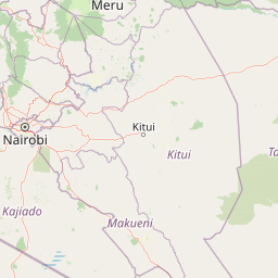
Map view of Aberdare National Park

Use this park location map to pinpoint Aberdare National Park in Kenya, understand its exact geographic position, and read its mapped placement within the surrounding landscape more clearly.

Pigeon | © OpenStreetMap contributors

Location context for Aberdare National Park

Nyandarua CountyNyeri County
Park atlas

Map the diverse protected landscapes of central Kenya, comparing national parks and reserves surrounding the Aberdare Range.

Explore National Parks Near Aberdare National Park, Discover Adjacent Protected Areas in Kenya
Continue your exploration beyond Aberdare National Park by browsing a curated selection of other national parks and protected areas across Kenya's central highlands and Rift Valley region. Understand the geographic distribution and ecological connections among these significant conservation landscapes, comparing their unique features and protected habitats within a broader regional context.
National parkNakuru County

Hell's Gate National Park: National Park Atlas and Mapped Landscape Exploration

Discover Nakuru County's protected terrain and geographic context.

Explore the mapped boundaries and unique geographic identity of Hell's Gate National Park, a protected national park within Kenya's Nakuru County. This detailed atlas view focuses on the park's natural landscape and its place within the regional geography, offering structured discovery of its protected terrain and surrounding context. Understand the visual and geographic essence of this significant conservation area.

Area
68.25 km²
Established
1984
IUCN
II
Relief
Mountain
National parkKenya

Mount Kenya National Park: Mapped Volcanic Landscape & Protected Area Geography

Kenya's high-altitude Afro-alpine ecosystems and mapped park boundaries.

Mount Kenya National Park safeguards a globally significant volcanic landscape and vital water resources for Kenya. This protected area above 3,000 meters features dramatic peaks, glaciers, and distinctive Afro-alpine flora. Explore its comprehensive mapped boundaries, understand its regional geographic importance, and discover the unique ecosystems that define this exceptional national park through detailed atlas context.

Area
715 km²
Established
1949
IUCN
II
Relief
Mountain
National parkKenya

Nairobi National Park: Detailed Geographic Overview and Protected Landscape Atlas

Explore the mapped boundaries and regional context of this Kenyan national park.

Nairobi National Park represents a significant protected national park entity within Kenya. This MoriAtlas entry provides detailed insight into its geographic placement and mapped landscape characteristics. Users can delve into the park's specific location, its protected boundaries, and its contribution to the regional geography of East Africa, facilitating structured map-based exploration and understanding of this vital conservation area.

Area
117 km²
Established
1946
IUCN
II
Relief
Mixed relief
National parkEastern Province

Meru National Park National Park: Mapped Protected Boundaries and Eastern Province Geography

Explore regional landscape context and natural terrain.

Meru National Park represents a vital national park entity within the Eastern Province of Kenya, offering unique opportunities for structured geographic and atlas exploration. This page details its protected landscape identity, emphasizing mapped boundaries and the surrounding regional context. Users interested in conservation lands and natural terrain can find comprehensive details on Meru National Park's geographic significance and its role within the broader atlas of protected areas.

Area
870.44 km²
Established
1966
IUCN
II
Relief
Upland
National parkTana River County

Kora National Park: A Unique Protected Landscape in Tana River County, Kenya

Explore its inselberg geography and mapped natural terrain.

Kora National Park represents a remarkable protected area characterized by its striking inselberg topography and semi-arid bushland, set against the backdrop of the Tana River. This national park in Tana River County offers a unique geographic profile, featuring massive granite formations that punctuate the expansive terrain. Discover the mapped boundaries and the distinctive landscape that make Kora National Park a significant entity for regional atlas exploration and understanding protected lands in eastern Africa.

Area
1,788 km²
Established
1989
IUCN
II
Relief
Mixed relief
National parkTrans-Nzoia County

Saiwa Swamp National Park National Park: Mapped Protected Area in Trans-Nzoia County

Explore the geographic context and protected landscape features.

Saiwa Swamp National Park serves as a vital national park within Trans-Nzoia County, Kenya, offering a unique perspective on protected lands. This page details its mapped geography and landscape characteristics, providing essential context for atlas-based exploration of its protected boundaries and regional setting. Understand the specific features that define this important conservation area.

Area
3 km²
Established
1974
IUCN
II
Relief
Lowland
National parkKenya

Amboseli National Park: Kenya National Park Protected Landscape Atlas

Mapped geographic context and protected area boundaries.

Amboseli National Park is a protected national park in Kenya, offering a distinct geographic entity for exploration. This atlas-focused view details the park's mapped boundaries and regional landscape context. Understand its role as a national park and a significant protected area within the broader geography of Kenya for structured discovery.

Area
392 km²
Established
1974
IUCN
II
Visitors
120K annual
National parkNyanza Province

Ruma National Park: Kenya National Park within Nyanza Province Geographic Atlas

Explore its protected landscape and mapped geographic boundaries.

This MoriAtlas entry details Ruma National Park, a designated national park situated in Kenya's Nyanza Province. The focus is on its identity as a protected landscape, its specific geographic footprint, and its representation within a mapped atlas of natural areas. Users can investigate the park's terrain context, its regional placement, and the precise nature of its protected boundaries, offering structured geographic insight.

Area
120 km²
Established
1983
IUCN
II
Relief
Lowland

Common questions about visiting, size, designation, and location context for Aberdare National Park

Aberdare National Park FAQs for park facts, access, geography, and protected area context
Find quick answers about Aberdare National Park, including protected-area facts, park geography, trail and visitor context, and how the park fits into its surrounding country and regional landscape.
MoriAtlas Explorer

Continue Your Protected Areas Search Across the Global Atlas

Deepen your exploration by continuing the structured search for national parks and protected areas worldwide. Utilize the comprehensive filtering capabilities to compare different conservation landscapes and refine your understanding of global park geography. Discover more about the distribution and characteristics of protected natural areas.

Global natural geography