

Mori Atlas logo
Wildlife reserveAiro Pai Communal Reserve

Mapping the seasonal forest dynamics and communal conservation territories of the Peruvian Amazon

Airo Pai Communal Reserve: A Protected Wildlife Landscape in the Loreto Region of Peru

(Reserva Comunal Airo Pai)

The Airo Pai Communal Reserve encompasses a vast mosaic of Amazonian terrain within the Loreto Region, integrating terra firme upland forests with seasonally flooded lowlands and palm swamps. This protected wildlife reserve balances ecological preservation with the traditional stewardship of Secoya and Kichwa Indigenous communities. Its geographic boundaries safeguard critical habitats for aquatic species including the Amazonian manatee and the giant South American river turtle.

Amazonian forestupland forestpalm swampseasonally flooded lowlandcommunal reserveIndigenous territory

Airo Pai Communal Reserve

Wildlife reserve

Park overview

Structured park overview, official facts, and landscape profile for Airo Pai Communal Reserve

Airo Pai Communal Reserve park facts, protected area profile, and essential visitor context

Review the core facts for Airo Pai Communal Reserve, including designation, size, terrain, visitor scale, habitats, and operating context in one park-focused overview.

About Airo Pai Communal Reserve

The Airo Pai Communal Reserve is one of Peru's Amazonian communal reserves, a category of protected area designed to preserve ecosystems while respecting the traditional uses of lands inhabited by Indigenous communities. It occupies a significant position in the Loreto Region, the heart of Peruvian Amazonia, and straddles the provinces of Maynas and Putumayo in the country's northwestern Amazon basin.

Ecologically, the reserve encompasses a representative cross-section of lowland Amazonian environments. Upland terra firme forests rise above the flood line, while palm swamps and seasonally inundated lowlands form the wetter, more dynamic half of the landscape. These contrasting forest types, shaped by local topography and drainage patterns, support different sets of plant communities, aquatic habitats, and animal populations throughout the year.

Culturally, Airo Pai reflects Peru's model of communal reserves as territories where conservation and Indigenous land use are intertwined rather than opposed. The Secoya and Kichwa communities traditionally associated with the area continue to maintain cultural practices, traditional pathways, and connections to sacred sites, while subsistence activities and small-scale ecotourism link conservation to local livelihoods.

The reserve is managed by SERNANP, the national authority for Peru's protected natural areas, and its establishment by Supreme Decree in 2012 placed it within the country's broader network of natural protected areas. Its IUCN Category VI status formally recognizes the sustainable use of natural resources as part of its conservation approach, reflecting the balance the reserve aims to maintain between ecological protection, cultural heritage, and community welfare.

Quick facts and research context for Airo Pai Communal Reserve

Airo Pai Communal Reserve is located in the Loreto Region of northern Peru, covering territory in both Maynas Province and Putumayo Province. Established on 25 October 2012 by Supreme Decree No. 006-2012-MINAM, it is classified by IUCN as a category VI protected area with sustainable use of natural resources, a designation well suited to its communal reserve model.

The reserve protects an extensive tract of Amazonian forest, including upland formations, palm swamps, and seasonally flooded lowlands. It is managed by SERNANP, Peru's national service of protected natural areas, and exists alongside Indigenous Secoya and Kichwa communities whose traditional presence is central to the reserve's identity and purpose.

Protection and recognition

Documented terrestrial protection scope, designation history, and management metrics.

Airo Pai Communal Reserve Protection Status and International Recognition Data

Airo Pai Communal Reserve maintains a documented terrestrial protection scope within the global conservation registry. Official protection status records outline baseline management parameters and recognized administrative frameworks.

Protection details

Protection scope
Terrestrial
Transboundary protection
No
Park context

Deeper park guide and search-rich context for Airo Pai Communal Reserve

Airo Pai Communal Reserve history, landscape, wildlife, and travel context

Explore Airo Pai Communal Reserve through its history, landscape character, ecosystems, wildlife, conservation priorities, cultural context, and seasonal travel timing in a structured park guide built for atlas discovery and search intent.

Why Airo Pai Communal Reserve stands out

Airo Pai is best known for being a community-rooted Amazonian reserve that protects a hydrologically dynamic forest landscape, including upland forests, palm swamps, and seasonally flooded lowlands. Its profile is shaped less by a single iconic landmark and more by its combined ecological and cultural value. The reserve's identity is closely tied to the Indigenous communities that inhabit and steward it, particularly the Secoya and Kichwa peoples, whose traditional pathways, livelihoods, and sacred sites coexist with the protected landscape. It is also recognized for safeguarding emblematic Amazonian aquatic species such as the Amazonian manatee, the giant South American river turtle, and the paiche.

Airo Pai Communal Reserve history and protected-area timeline

The Airo Pai Communal Reserve was formally created on 25 October 2012 through Supreme Decree No. 006-2012-MINAM, placing it within Peru's national system of protected natural areas managed by SERNANP. Its establishment followed the country's evolving approach to communal reserves, a category designed to protect biodiversity while recognizing the rights, traditions, and resource use of Indigenous peoples living within the territory.

The reserve's recognition reflects the longstanding presence of Indigenous Secoya and Kichwa communities in this part of the Loreto Region, whose traditional pathways, livelihoods, and sacred sites predate the formal declaration of the protected area. The creation of Airo Pai gave national legal status to this coexistence of Indigenous cultural heritage and Amazonian ecosystems, anchoring it within Peru's broader conservation framework.

Airo Pai Communal Reserve landscape and geographic character

The landscape of the Airo Pai Communal Reserve is shaped by the hydrology of the northwestern Peruvian Amazon. The terrain is predominantly lowland, built from a subtle mosaic of upland forest, palm swamp, and seasonally flooded lowland, each responding differently to the rise and fall of regional waters.

Upland terra firme forests occupy the higher, well-drained portions of the reserve, forming a continuous canopy above the flood line. Palm swamps create distinctive open, palm-dominated vegetation in areas where water lingers, while the seasonally flooded lowlands expand and contract with the wet and dry seasons, temporarily transforming large parts of the forest into shallow aquatic habitat. Together these features give the reserve a striking seasonal character typical of the Amazon basin.

Airo Pai Communal Reserve ecosystems, habitats, and plant life

The natural environment of Airo Pai is a mosaic of Amazonian ecosystems rather than a single uniform forest. Upland terra firme forests provide the structural backbone of the reserve, while palm swamps add a distinctive vegetation pattern in waterlogged areas. Seasonally flooded lowlands introduce a shifting ecological dimension as water levels rise and recede through the year, supporting animals and plants adapted to fluctuating conditions.

This variety of habitat types supports a rich array of aquatic and terrestrial life. The reserve's waters and floodplains are particularly important for large, regionally significant species that depend on the connectivity of Amazonian rivers and flooded forests, while the upland forests provide additional terrestrial habitat. The interplay of dryland and flooded forest is the defining ecological feature of the area.

Airo Pai Communal Reserve wildlife and species highlights

The wildlife of Airo Pai includes species emblematic of broader Amazonian conservation interest. Among the most notable are the Amazonian manatee, a large aquatic mammal associated with flooded habitats and slow-moving waters; the giant South American river turtle (Podocnemis expansa), whose nesting beaches and riverine habitat fall within the reserve's seasonal cycle; and the paiche (Arapaima gigas), one of the world's largest freshwater fish and a signature species of Amazonian floodplain ecosystems.

These species reflect the reserve's importance for animals that depend on the connectivity between rivers, floodplains, and forests. The surrounding upland and flooded forests also support the broader terrestrial fauna typical of the western Amazon, contributing to the area's overall biodiversity value.

Airo Pai Communal Reserve conservation status and protection priorities

The Airo Pai Communal Reserve plays a specific role within Peru's conservation framework as a communal reserve, a category tailored to territories where Indigenous communities have longstanding cultural and resource-use ties to the landscape. Its designation under IUCN Category VI emphasizes that conservation here is closely linked to sustainable use of natural resources rather than strict exclusion.

The reserve contributes to protecting representative Amazonian ecosystems, including upland forests, palm swamps, and seasonally flooded lowlands, while safeguarding regionally significant aquatic species such as the Amazonian manatee, the giant South American river turtle, and the paiche. Its conservation value is therefore both ecological, in terms of habitat protection and species persistence, and sociocultural, in terms of preserving the traditional practices and territories of the Secoya and Kichwa communities that inhabit it.

Airo Pai Communal Reserve cultural meaning and human context

Cultural identity is central to the reserve's purpose. The Airo Pai Communal Reserve is home to Indigenous Secoya and Kichwa communities, whose longstanding presence in this part of the Loreto Region predates the formal establishment of the protected area. The reserve's communal designation reflects recognition of their traditional land use and heritage.

Communities within Airo Pai continue to use traditional pathways that link different parts of the forest, maintain connections to sacred sites, and engage in subsistence activities tied to the rhythms of the forest and its waters. Small-scale ecotourism adds a contemporary layer to these traditional uses, creating a livelihood link between cultural preservation and the conservation of the surrounding landscape.

Top sights and standout views in Airo Pai Communal Reserve

Airo Pai stands out for combining lowland Amazonian forest conservation with a community-rooted management approach. Its mix of upland forests, palm swamps, and seasonally flooded lowlands captures the ecological diversity typical of the northwestern Peruvian Amazon, while its designation as a communal reserve places Indigenous heritage at the center of its identity.

The reserve's role in protecting large, regionally significant aquatic species such as the Amazonian manatee, the giant South American river turtle, and the paiche adds a distinctive conservation dimension that complements its cultural significance.

Best time to visit Airo Pai Communal Reserve

The character of a visit to the Airo Pai Communal Reserve is shaped by the seasonal rhythm of the Amazon basin. The wet season brings higher water levels that expand flooded lowlands and palm swamps, intensify river travel conditions, and create peak habitat for aquatic species associated with floodplains. The drier months reduce flooding and can make terrestrial forest walks and overland access easier, while concentrating wildlife around remaining water bodies.

Seasonal choices therefore depend on whether a visitor prioritizes flooded-forest landscapes and aquatic wildlife, which are most visible during high-water periods, or more accessible upland forest exploration during the drier season. In all cases, visits depend on the rhythms of the forest and the practical realities of travel in remote Amazonian terrain.

Monthly climate preview

Long-term representative temperature and precipitation patterns across twelve monthly records

Airo Pai Communal Reserve Climate Normals and Annual Weather by Month

Representative coordinate measurements record consistent monthly thermal averages alongside varying precipitation rates throughout the annual cycle at Airo Pai Communal Reserve. Examining the complete twelve-month climatology profile provides deeper analytical context for long-term temperature ranges and monthly rainfall trends.
Annual mean25 °C
24 °C25 °C
Jan25°
Feb25°
Mar25°
Apr25°
May25°
Jun24°
Jul24°
Aug25°
Sep25°
Oct25°
Nov25°
Dec25°
Warmest month
February

25.4 °C

Coolest month
July

24 °C

Wettest month
May

9.8 mm/day

Driest month
January

4.4 mm/day

Park location guide

Geography guide, regional context, and park location map for Airo Pai Communal Reserve

Airo Pai Communal Reserve park geography, regions, and map view in Peru

Understand where Airo Pai Communal Reserve sits in Peru through a broader geographic reading of the surrounding landscape, nearby location context, and its mapped position within the national park landscape.

How Airo Pai Communal Reserve fits into Peru

Peru is a megadiverse country in western South America with a population of over 34 million. It spans three distinct geographic regions: the Pacific coastal desert in the west, the Andes mountains running north to south, and the Amazon rainforest in the east. The country has one of the longest histories of civilization in the world, tracing back to the Caral-Supe civilization of the 10th millennium BCE, and was home to the Inca Empire before Spanish colonization in the 16th century.

Wider geography shaping Airo Pai Communal Reserve in Peru

Peru is located in western South America along the Pacific coast. The country encompasses three major geographic regions: the coastal desert plains along the Pacific, the Andes mountain range extending from north to southeast, and the Amazon basin rainforest in the eastern interior. It shares borders with Ecuador and Colombia to the north, Brazil to the east, Bolivia to the southeast, and Chile to the south.

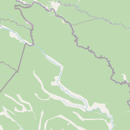
Map view of Airo Pai Communal Reserve

Use this park location map to pinpoint Airo Pai Communal Reserve in Peru, understand its exact geographic position, and read its mapped placement within the surrounding landscape more clearly.

Pigeon | © OpenStreetMap contributors

Location context for Airo Pai Communal Reserve

Loreto Region
Natural feature types

Explore the Natural Landscapes of the Airo Pai Communal Reserve

Trace the diverse geographic features and protected Amazonian environments that define the Airo Pai Communal Reserve. MoriAtlas organizes these landmarks to help users visualize the terrain, water systems, and forest mosaics that constitute this significant Indigenous communal territory in northern Peru.
Park atlas

Compare nearby Amazonian landscapes and regional protected areas in northern Peru.

Explore Parks Near Airo Pai Communal Reserve and Surrounding Protected Areas

Browse other protected areas and forest reserves located across the surrounding northwestern Amazonian region. Discovering adjacent natural habitats provides broader geographic context for regional conservation terrain.
National parkPeru
Park boundaries overlap#1 closest

North

Güeppi-Sekime National Park: Protected National Park Atlas in Peru

Mapped landscape and regional geography of this Amazonian protected area.

Güeppi-Sekime National Park is a prominent protected area in Peru, recognized as a national park safeguarding a substantial expanse of tropical forest. Its landscape is characterized by diverse terrain, including rolling hills and seasonally inundated lowlands, vital for a rich tapestry of flora and fauna. The park's strategic location on the Ecuador border underscores its importance for transboundary conservation and ecological connectivity within the western Amazon basin. This page offers detailed information on its protected area identity, geographic context, and the mapped natural features that define this significant conservation landscape.

Area
2,036 km²
Established
2012
IUCN
II
Relief
Mixed relief
Wildlife reserveLoreto Region
Park boundaries overlap#2 closest

North

Huimeki Communal Reserve: Amazonian Geography and Protected Forest Atlas

Key wildlife reserve located in the Loreto Region, Peru

Huimeki Communal Reserve stands as a sentinel of the Putumayo basin, protecting vital lowland Amazonian environments. This reserve serves as a crucial link in a wider ecological corridor, preserving habitats that are restricted to this remote northeastern frontier of the Peruvian landscape.

Area
1,412.34 km²
Established
2012
IUCN
VI
Relief
Lowland
Wildlife reserveSucumbíos
Park boundaries overlap#3 closest

Northwest

Reserva de Producción de Fauna Cuyabeno: Geography of an Amazonian Wildlife Reserve

Explore protected boundaries and flooded landscape patterns in Sucumbíos

Reserva de Producción de Fauna Cuyabeno serves as a benchmark for Amazonian conservation, characterized by its extraordinary hydrological dynamics. The landscape comprises a network of blackwater rivers and semi-permanent lagoons that sustain an immense variety of species. As a protected area within Sucumbíos, it showcases the intricate relationship between seasonally submerged forests, terra firme terrain, and the vital river arteries that define this region.

Area
5,901.12 km²
Established
1979
IUCN
VI
Visitors
12K annual
National parkEcuador
24 km away#4 closest

Southwest

Yasuní National Park: Ecuador's Protected Landscape and Geographic Atlas Entry

Explore the mapped boundaries and regional terrain of this key national park.

Delve into the atlas-level details of Yasuní National Park, Ecuador's designated national park. This entry provides essential geographic context, focusing on the park's mapped boundaries and its role as a protected landscape within the region. Understand the specific terrain and protected area distribution that makes Yasuní National Park a significant point of geographic interest for atlas exploration.

Area
10,227.4 km²
Established
1979
IUCN
II
Relief
Lowland
Wildlife reserveSucumbíos
145 km away#5 closest

West

Reserva Biológica Limoncocha: Geography, Wetland Ecosystems, and Protected Boundaries

A vital Amazonian wildlife reserve in the Sucumbíos province.

Reserva Biológica Limoncocha is a distinctive wetland reserve defined by its intricate system of lagoons, rivers, and seasonal floodplains. Its geography provides a rare look at Amazonian biodiversity, ranging from elevated forest plateaus to permanently inundated palm swamps and vital black caiman habitats.

Area
46.13 km²
Established
1985
IUCN
VI
Relief
Lowland
National parkEcuador
224 km away#6 closest

West

Sumaco Napo-Galeras National Park: Ecuador's Volcanic National Park Landscape

Explore protected areas and biodiversity in the Andean-Amazon transition.

Sumaco Napo-Galeras National Park protects a dramatic volcanic landscape in Ecuador, showcasing a significant elevation gradient that supports diverse cloud forest and Amazonian rainforest habitats. This national park is recognized for its endemic species and rich avifauna, offering a compelling case study for understanding protected land geography and ecological transitions within South America.

Area
2,067.49 km²
Established
1994
IUCN
II
Relief
Mountain
Nature reserveSucumbíos
228 km away#7 closest

West

Reserva Ecológica Cofán-Bermejo: Mapping Amazonian and Andean Biodiversity Landscapes

Indigenous-led conservation in the Sucumbíos river headwaters.

Reserva Ecológica Cofán-Bermejo encompasses a remarkable altitudinal range from 400 to 2,200 meters, protecting intact river basins and transitional ecosystems. This nature reserve offers deep insight into the convergence of Amazonian and Andean flora, functioning as a vital refuge for threatened megafauna and rare bird populations within an indigenous-managed territory.

Area
549.47 km²
Established
2002
IUCN
Ia
Relief
Mountain
Protected areaColombia
About 235 km away#8 closest

Northwest

Santuario Orito Indí-Andé Fauna and Flora Sanctuary: A Protected Area's Geographic and Landscape Identity in Colombia

Explore mapped boundaries and regional natural terrain context.

Gain insight into Santuario Orito Indí-Andé Fauna and Flora Sanctuary, a vital protected area contributing to Colombia's conservation landscape. This entry focuses on its distinct geographic characteristics and mapped territory. Understand the park's place within the national atlas and its contribution to regional geographic knowledge. It provides a structured foundation for exploring the natural terrain and protected boundaries specific to this important Colombian sanctuary.

Area
1,020 km²
Established
2008
Relief
Mountain
Access
Access unknown

Common questions about visiting, size, designation, and location context for Airo Pai Communal Reserve

Airo Pai Communal Reserve FAQs for park facts, access, geography, and protected area context

Find quick answers about Airo Pai Communal Reserve, including protected-area facts, park geography, trail and visitor context, and how the park fits into its surrounding country and regional landscape.
MoriAtlas Explorer

Continue Your Protected Areas Search Across the Global Atlas

Deepen your exploration by continuing the structured search for national parks and protected areas worldwide. Utilize the comprehensive filtering capabilities to compare different conservation landscapes and refine your understanding of global park geography. Discover more about the distribution and characteristics of protected natural areas.

Global natural geography
