Mori Atlas logo
Protected landscapeAmistad National Recreation Area

Trace the confluence of the Rio Grande and reservoir terrain within this expansive border-country geography.

Amistad National Recreation Area: A Comprehensive Mapping of Texas Protected Canyon Landscapes

Amistad National Recreation Area serves as a pivotal protected landscape in Texas where the arid Chihuahuan Desert meets the deep waters of the Amistad Reservoir. This site encompasses the rugged canyon geography formed by the meeting of the Rio Grande, Devils River, and Pecos River along the international border. Users can analyze the park's intricate limestone shorelines and vast reservoir expanse to understand its role in regional water-based ecosystems and prehistoric cultural heritage.

national recreation areareservoirChihuahuan DesertRio Grandeborder countrylimestone canyon scenery

Amistad National Recreation Area

Protected landscape

Park overview

Structured park overview, official facts, and landscape profile for Amistad National Recreation Area

Amistad National Recreation Area park facts, protected area profile, and essential visitor context

Review the core facts for Amistad National Recreation Area, including designation, size, terrain, visitor scale, habitats, and operating context in one park-focused overview.

About Amistad National Recreation Area

Amistad National Recreation Area centers on a large reservoir impounded by Amistad Dam on the Rio Grande, where this great border river is joined by two of its major Texas tributaries, the Devils River and the Pecos River. From the lake, the surrounding terrain rises into the limestone hills and brushy canyons of the northern Chihuahuan Desert, creating a setting where arid Southwest scenery and a vast body of water meet at the international boundary with Mexico. The reservoir's irregular shoreline, studded with rocky coves, draws, and steep banks, has made Amistad one of the most striking water-based landscapes in the National Park System.

The recreation area is administered by the National Park Service and offers a wide range of outdoor activities tied to its reservoir setting. Year-round water-based pursuits include boating, fishing, swimming, water-skiing, and increasingly technical scuba diving in the deep underwater cave systems beneath the lake. On land, visitors can picnic, camp, hike, and hunt in designated areas under state and federal regulations, with bow-hunting opportunities for species such as white-tailed deer, javelina, turkey, feral hog, and exotic game like aoudad and mouflon sheep, while shotgun hunting is allowed for dove, quail, duck, and rabbit in line with park rules.

Beyond recreation, Amistad stands out for its deep cultural and natural history. The cliffs above the reservoir contain some of the most significant prehistoric rock art in North America, including the celebrated Panther Cave site, an enduring image of a great cat rendered by the indigenous peoples of the Lower Pecos region. Botanically and ecologically, the area blends desert scrub and riparian corridors into a varied habitat mosaic. In autumn, the site takes on another identity entirely, serving as a staging and resting ground for thousands of monarch butterflies during their multigenerational migration from southern Canada to the forests of central Mexico, often roosting together in clusters before continuing south.

Quick facts and research context for Amistad National Recreation Area

Amistad National Recreation Area is a National Park Service unit covering roughly 58,500 acres around Amistad Reservoir in Val Verde County, Texas. It lies at the meeting point of the Rio Grande, the Devils River, and the Pecos River, just south of Del Rio and across the border from Ciudad Acuña, Coahuila. The reservoir was created by Amistad Dam, which was completed in 1969. The site was first managed by the National Park Service under a cooperative agreement effective November 11, 1965, and was reauthorized as a national recreation area on November 28, 1990.

Protection and recognition

Terrestrial protected area history established in the year 1990

Amistad National Recreation Area Protection Status and Designation Records

Amistad National Recreation Area maintains documented terrestrial protection status established in 1990 without imported international recognition sources. Structured preservation records outline the operational scope and baseline designation history for this conserved landscape.

Protection details

Protection scope
Terrestrial
Designated year
1990
Transboundary protection
No
Park context

Deeper park guide and search-rich context for Amistad National Recreation Area

Amistad National Recreation Area history, landscape, wildlife, and travel context

Explore Amistad National Recreation Area through its history, landscape character, ecosystems, wildlife, conservation priorities, cultural context, and seasonal travel timing in a structured park guide built for atlas discovery and search intent.

Why Amistad National Recreation Area stands out

Amistad is best known for the deep blue waters of the Amistad Reservoir and the rugged desert canyon scenery that surrounds it, where the Rio Grande, Devils River, and Pecos River converge along the United States-Mexico border. It is also recognized for its exceptional Lower Pecos rock art, anchored by the ancient Panther Cave petroglyph site, and for the annual passage of thousands of monarch butterflies each fall as they travel from southern Canada down to the mountains of central Mexico. Together these features make the recreation area distinctive among the National Park System's water-based sites in the Southwest.
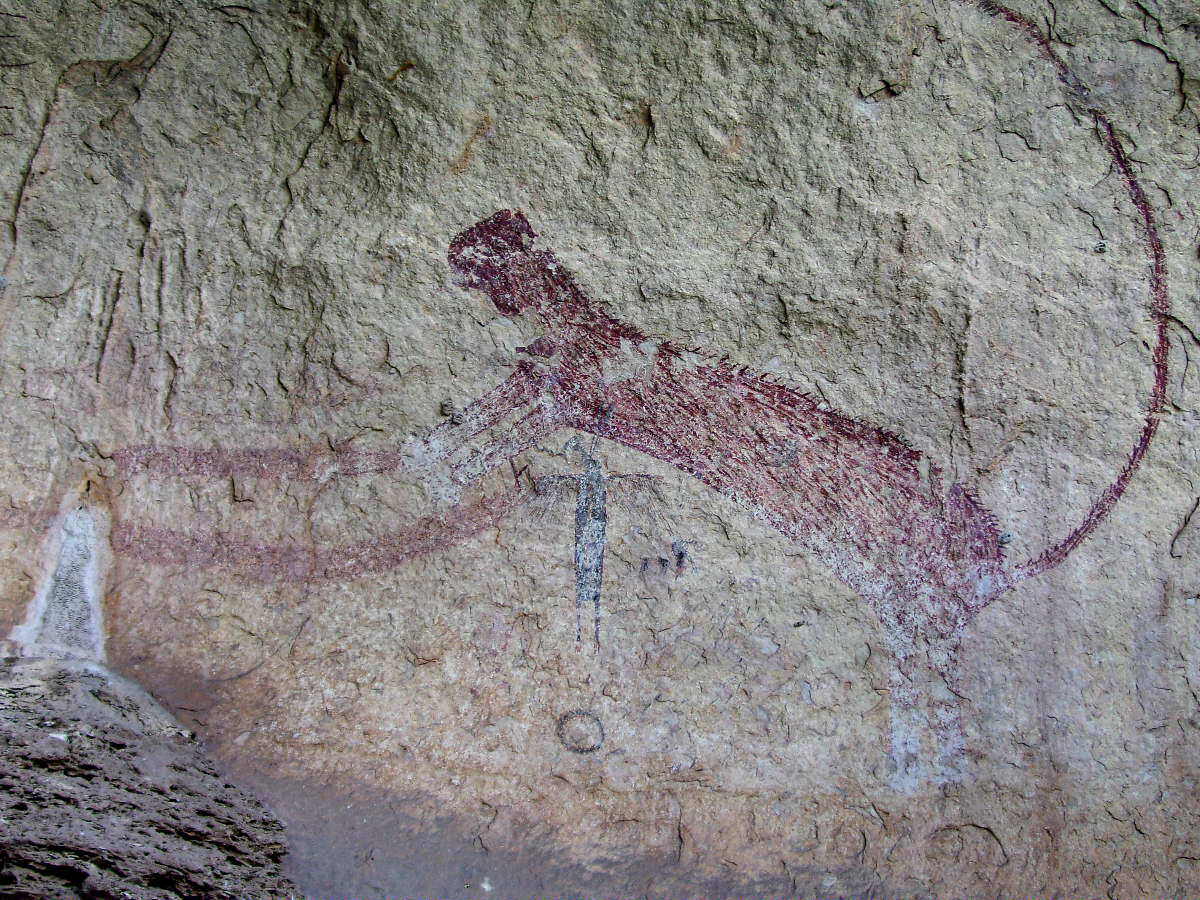
A reddish-brown, long-tailed panther pictograph painted on a weathered, rough limestone rock surface.
The Panther Cave petroglyph, an ancient pictograph located within Amistad National Recreation Area.

Amistad National Recreation Area history and protected-area timeline

Amistad National Recreation Area originated as a cooperative venture between the National Park Service and the International Boundary and Water Commission. Beginning on November 11, 1965, the Service managed the site as the Amistad Recreation Area under a cooperative agreement tied to the operation of Amistad Dam, which was completed in 1969. For a quarter century the area existed in this collaborative framework, serving visitors drawn to the new reservoir on the Rio Grande.

Its status was strengthened on November 28, 1990, when Congress reauthorized the site as a national recreation area and a unit of the National Park System, formalizing its long-term role in the National Park Service. The name Amistad, meaning friendship in Spanish, reflects the close relationship between Del Rio, Texas, and Ciudad Acuña across the border in Coahuila, a partnership symbolized by the shared dam and reservoir at the heart of the recreation area.

Amistad National Recreation Area landscape and geographic character

The landscape of Amistad National Recreation Area is defined by the meeting of water and desert. The Amistad Reservoir fills the lower reaches of three river systems, the Rio Grande, the Devils River, and the Pecos River, producing an irregular, fjord-like shoreline that cuts deep into the surrounding terrain. Banks rise in rocky shelves and steep limestone slopes, while sheltered coves and quiet backwaters thread between bluffs and benches of harder stone.

Away from the water, the land quickly gives way to classic Chihuahuan Desert scenery: low, brushy hills, arroyos, and exposed limestone outcrops painted in muted grays, tans, and rusts. Vegetation is sparse but tough, dominated by drought-adapted shrubs and small trees that frame long sightlines across the reservoir. The terrain produces sweeping vistas where lake and canyon country mingle, especially at sunset, when the cliffs glow against the darkening water.
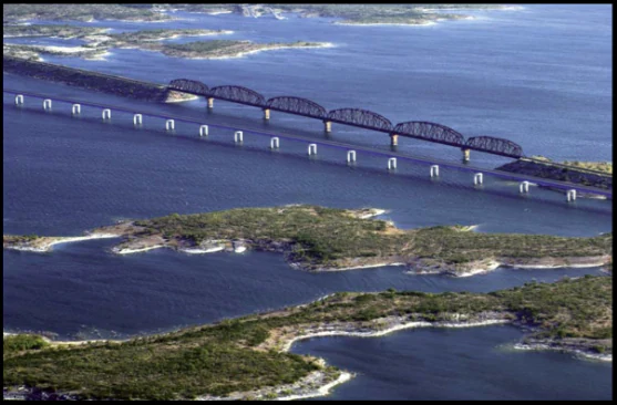
An aerial view showing two long bridges crossing a large body of dark blue water with several small, rocky islands and shrubby vegetation in the foreground.
Aerial view of the Southern Pacific Railroad and US 90 bridges crossing Amistad Reservoir in Texas.

Amistad National Recreation Area ecosystems, habitats, and plant life

Ecologically, Amistad sits at the junction of desert, river, and reservoir environments. The uplands support thorny brushland and cactus-studded slopes typical of the northern Chihuahuan Desert, while the riparian zones along the reservoir and its tributary canyons hold denser growth of willows, mesquite, and other water-loving trees. The mixing of these habitats creates an unusually rich ecological gradient for a desert park, supporting communities of plants and animals suited to very different conditions within a short distance of one another.

The reservoir itself is a major biological feature, sustaining warm-water fish populations and providing habitat for waterbirds along its shoreline and shallow margins. The varied topography and habitat types make the recreation area a notable zone of overlap between arid Southwest ecosystems and the more humid environments of the rivers that feed it, giving Amistad a distinctive ecological character within the National Park System.
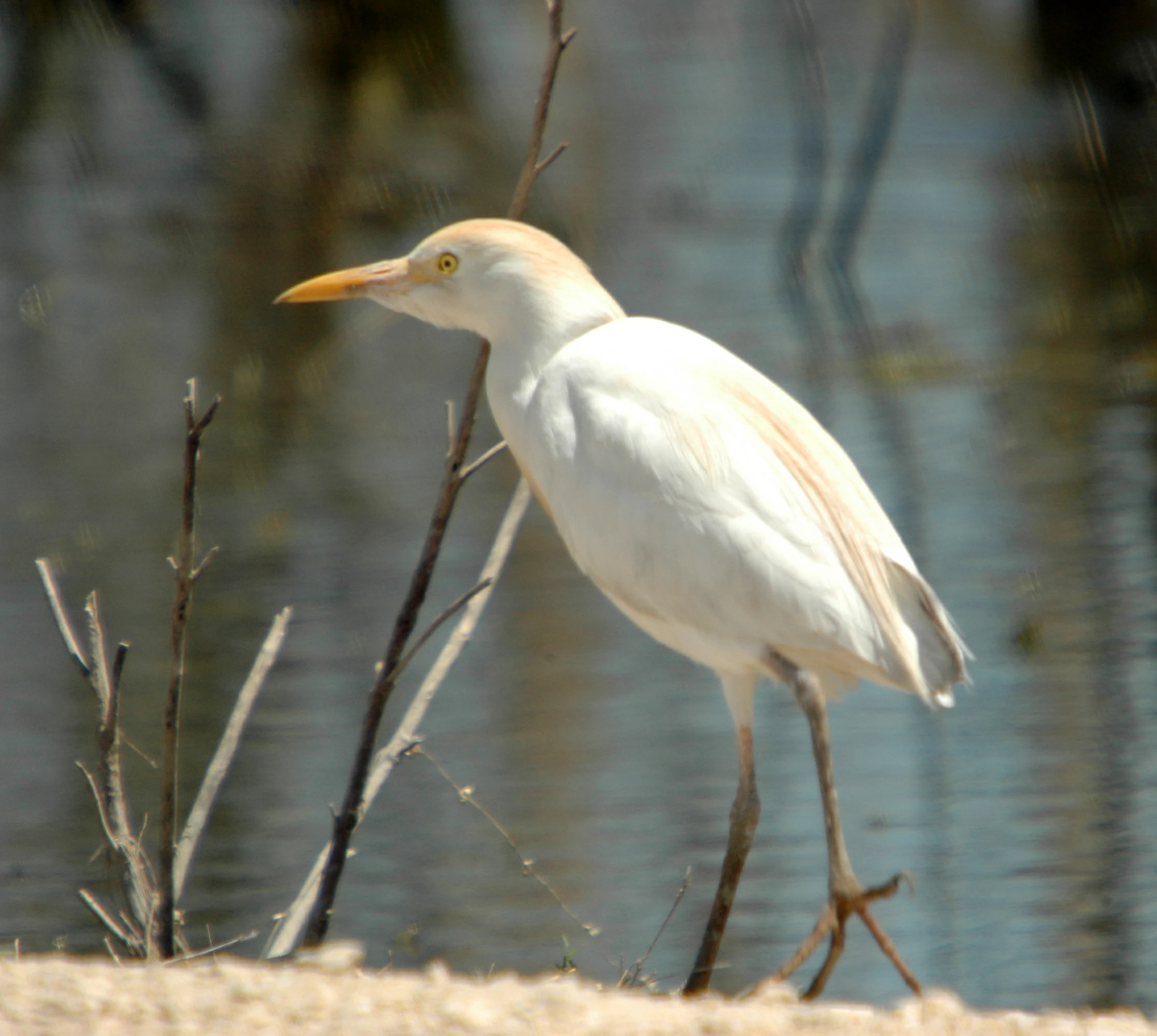
A white cattle egret with buff-colored feathers on its head and back stands in profile near a body of water with bare branches in the background.
A cattle egret in breeding plumage standing near the water at Amistad National Recreation Area.

Amistad National Recreation Area wildlife and species highlights

The wildlife profile at Amistad combines classic Chihuahuan Desert species with aquatic and migratory visitors. The uplands host white-tailed deer, javelina, wild turkey, and rabbit, along with free-ranging exotics such as mouflon sheep, aoudad sheep, and blackbuck antelope, which contribute to the area's unusual hunting opportunities. Feral hogs add another opportunistic presence to the brush country.

The reservoir and its shorelines attract herons, egrets, and other waterbirds, while songbirds and raptors move through the surrounding canyons. One of the most celebrated wildlife events occurs each fall, when thousands of monarch butterflies pass through the recreation area on their southward journey from southern Canada to the forests of central Mexico. They sometimes gather in large roosting clusters before continuing their migration, turning stretches of vegetation into living aggregations of orange and black during peak weeks.

A dense group of monarch butterflies with folded wings showing orange and black patterns, clinging to tree branches.
A cluster of migrating monarch butterflies roosting on tree branches at Amistad National Recreation Area.

Amistad National Recreation Area conservation status and protection priorities

Amistad National Recreation Area plays a conservation role out of proportion to its recreational identity. The site protects the reservoir shoreline and surrounding desert lands across the international boundary, preserving habitat for desert wildlife, riparian species, and the diverse plant communities of the Lower Pecos region. Its management status as a National Park Service unit provides a framework of protection that maintains water quality conditions, native vegetation, and the integrity of the cultural and natural resources along the Rio Grande.

A distinctive element of the park's conservation importance is its role as a refuge and waypoint for migratory species, most famously the monarch butterflies that funnel through the area each fall. The protection of rock art sites, including the jointly managed Panther Cave, also situates the recreation area as a custodian of irreplaceable cultural heritage in addition to its natural values.

Amistad National Recreation Area cultural meaning and human context

The cultural identity of Amistad is rooted in both the ancient and the modern. For thousands of years, the peoples of the Lower Pecos region left enduring marks on the canyon walls, and the recreation area protects some of their most striking work, including the figurative Panther Cave petroglyph of a powerful feline. This site is jointly managed with Seminole Canyon State Park and Historic Site, linking Amistad into a broader Lower Pecos cultural landscape.

On a more recent historical scale, the construction of Amistad Dam in the late 1960s reshaped the border country, creating a shared reservoir between the United States and Mexico. The recreational area reflects that binational relationship, with Del Rio and Ciudad Acuña tied together by the dam and the lake it created. The very name Amistad, meaning friendship, acknowledges this partnership, marking the site as a place where two nations share water, recreation, and a common borderland identity.

Top sights and standout views in Amistad National Recreation Area

Amistad National Recreation Area's standout features include the striking confluence of the Rio Grande, Devils River, and Pecos River, the deep blue expanse of Amistad Reservoir, and the rugged desert canyon scenery that frames them. Its Lower Pecos rock art, especially the Panther Cave petroglyph, gives the site lasting cultural significance, while the regular mass passage of monarch butterflies each fall provides one of the most unusual wildlife spectacles in the National Park System. Together these elements make Amistad a park where desert, river, reservoir, and ancient human history all converge.
Monthly climate preview

Long term temperature ranges and precipitation rhythm from representative coordinate data

Amistad National Recreation Area Climate Normals and Annual Weather Patterns

Amistad National Recreation Area exhibits a measured annual temperature and precipitation rhythm based on long term representative coordinate records spanning twelve distinct monthly intervals. Reviewing the complete monthly profile provides deeper insight into shifting thermal averages and moisture distribution across the representative park location.
Annual mean21 °C
11 °C30 °C
Jan11°
Feb14°
Mar18°
Apr23°
May27°
Jun30°
Jul30°
Aug30°
Sep27°
Oct22°
Nov16°
Dec11°
Warmest month
August

30.3 °C

Coolest month
January

10.8 °C

Wettest month
September

1.9 mm/day

Driest month
January

0.5 mm/day

Park location guide

Geography guide, regional context, and park location map for Amistad National Recreation Area

Amistad National Recreation Area park geography, regions, and map view in United States of America

Understand where Amistad National Recreation Area sits in United States of America through a broader geographic reading of the surrounding landscape, nearby location context, and its mapped position within the national park landscape.

How Amistad National Recreation Area fits into United States of America

The United States of America is a federal presidential republic and one of the world's largest countries by area and population. It consists of 50 states across a vast territory spanning multiple time zones, with its capital in Washington, D.C. and largest city in New York City. The nation has a diverse economy, influential political system, and significant cultural and military presence globally.

Wider geography shaping Amistad National Recreation Area in United States of America

The United States occupies a vast territory in North America, bordered by Canada to the north and Mexico to the south. The 48 contiguous states stretch from the Atlantic to the Pacific Ocean, while Alaska occupies the northwestern region and Hawaii is an archipelago in the Pacific. The country encompasses diverse terrain including the Rocky Mountains, Appalachian Mountains, Great Plains, and extensive river systems.

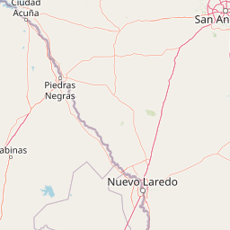
Map view of Amistad National Recreation Area

Use this park location map to pinpoint Amistad National Recreation Area in United States of America, understand its exact geographic position, and read its mapped placement within the surrounding landscape more clearly.

Pigeon | © OpenStreetMap contributors

Location context for Amistad National Recreation Area

Texas

Explore photographic records of Chihuahuan Desert terrain, reservoir shorelines, and limestone canyons

Visualizing Amistad National Recreation Area: Landscape Photography and Scenery

Amistad National Recreation Area photos capture the striking convergence of desert canyons, river confluences, and deep blue reservoir waters along the border. Visual exploration of these protected landscapes reveals the rugged topography, limestone cliffs, and arid habitats that define the region.

A reddish-brown, long-tailed panther pictograph painted on a weathered, rough limestone rock surface.

A sunset view over the still, reflective water of a large lake with bare trees partially submerged in the reservoir under a purple and orange sky.

An aerial view showing two long bridges crossing a large body of dark blue water with several small, rocky islands and shrubby vegetation in the foreground.

A white cattle egret with buff-colored feathers on its head and back stands in profile near a body of water with bare branches in the background.

A dense group of monarch butterflies with folded wings showing orange and black patterns, clinging to tree branches.

Park atlas

Compare surrounding desert canyon terrain and regional water recreation areas

Parks Near Amistad National Recreation Area And Related Protected Landscapes

Browse nearby national parks and protected areas sharing the border country and Chihuahuan Desert ecosystems of Amistad National Recreation Area. Regional park comparison reveals wider patterns in river confluences, limestone canyons, and water-based conservation lands.
Watercolor painting of soft, layered green mountain silhouettes against a pale sky.
Wildlife reserveCoahuila
About 161 km away#1 closest

West

Área de protección de flora y fauna Maderas del Carmen: Protected Desert Mountain Geography

Rugged limestone ranges and conservation corridors in northern Coahuila

The Área de protección de flora y fauna Maderas del Carmen protects an expansive, high-elevation desert mountain landscape. Featuring the Sierra del Carmen and Sierra el Jardín, the reserve bridges arid desert basins with forested upland terrain, creating one of northern Mexico's most significant ecological corridors for scientific study and wilderness preservation.

Area
2,083.81 km²
Established
1994
Relief
Mountain
Climate
Arid
National parkBrewster County
About 174 km away#2 closest

West

Big Bend National Park: National Park, Mapped Protected Landscape, and Regional Geography

Explore Brewster County's protected natural terrain.

Big Bend National Park is a prominent national park defined by its protected landscape and geographic features within Brewster County. This destination provides users with detailed atlas-style information, focusing on the park's mapped boundaries and its contribution to the understanding of regional natural geography. Delve into the specific context of this protected area to enhance your geographic discovery.

Area
3,242.19 km²
Established
1944
IUCN
II
Visitors
568.1K annual
Protected areaCoahuila
About 174 km away#3 closest

South

Cuenca Alimentadora del Distrito Nacional de Riego 004 Don Martín Protected Area Geography

A vast watershed and mountain corridor in central Coahuila

This expansive protected area in northern Mexico functions as the primary catchment for the Don Martín irrigation district. The terrain ranges from dry shrubland and grasslands in the Coahuila interior to the rugged, forested heights of the Sierra Madre Oriental. It remains a key case study in river conservation and the complex interplay between arid ecosystems and mountainous watershed systems.

Area
15,193.8 km²
Established
1949
IUCN
VI
Relief
Mountain
Wildlife reserveCoahuila
About 202 km away#4 closest

West

Ocampo Flora and Fauna Protection Area: Mapping Desert and Riverine Geography in Coahuila

A vital transboundary wildlife reserve in northern Mexico

Ocampo Flora and Fauna Protection Area provides a massive, contiguous block of protected wilderness characterized by rugged mountain foothills and desert flats. As a cornerstone of the El Carmen Big Bend Complex, the reserve offers a unique look at how river-cut canyons and arid scrublands support diverse life forms in the northern Chihuahuan Desert of Coahuila.

Area
3,442.38 km²
Established
2009
IUCN
VI
Relief
Mixed relief
A horizontal watercolor illustration depicting soft, rolling hills, a small stream in the foreground, and pine forests, using a muted pastel palette.
Wildlife reserveChihuahua
About 276 km away#5 closest

West

Área de Protección de Flora y Fauna Cañón de Santa Elena Wildlife Reserve Map and Geography

Chihuahuan Desert conservation area in Chihuahua, Mexico

This wildlife reserve protects a vast expanse of the Chihuahuan Desert along the Mexico-United States border. The landscape is defined by deep river-cut canyons, volcanic uplifts, and broad valleys. Discover the geological structure and ecological boundaries of this protected area, which mirrors the conservation efforts of neighboring regions to maintain a vital desert ecosystem.

Area
2,772.09 km²
Established
1994
Relief
Mountain
Climate
Arid
Watercolor painting of a desert landscape with white gypsum dunes, a central turquoise blue pool, and yucca plants.
Wildlife reserveCoahuila
About 297 km away#6 closest

South

Área de Protección de Flora y Fauna Cuatrociénegas: Protected Landscape and Atlas Map

Desert wetlands and gypsum dune geography in Coahuila, Mexico

This wildlife reserve in Coahuila represents a globally significant desert wetland complex. Featuring hundreds of spring-fed pozas and the second-largest gypsum dune field in the Americas, the reserve offers a unique look at isolated ecosystems and specialized biodiversity within the Chihuahuan Desert.

Area
843.47 km²
Established
1994
Relief
Lowland
Climate
Arid
Protected areaNuevo León
About 405 km away#7 closest

South

Sierra de Picachos Protected Area: Geographic Boundaries and Regional Landscapes

Mountain geography in northern Nuevo León

Sierra de Picachos represents a vital conservation zone spanning north of Monterrey. The landscape is defined by its dramatic elevation changes, moving from desert-like plains to cool coniferous slopes. This atlas entry focuses on the physical boundaries, ecological zones, and the rugged, peak-studded terrain that distinguish the range from the surrounding Sierra Madre Oriental.

Area
1,405 km²
Established
2000
Relief
Mountain
Climate
Subtropical
Nature reserveTexas
About 418 km away#8 closest

East

Mission-Aransas National Estuarine Research Reserve: A Texas Coastal Protected Landscape

Mapped estuarine habitats and regional coastal geography

Encompassing a unique mix of terrestrial and marine environments, Mission-Aransas National Estuarine Research Reserve stands as a significant protected corridor on the Texas Coast. The landscape features deep-water bays, sheltered seagrass meadows, and open coastal prairie, offering a clear view of how riverine processes shape the complex shoreline of the western Gulf of Mexico.

Relief
Lowland
Climate
Subtropical
Access
Easy access
Scope
Mixed

Common questions about visiting, size, designation, and location context for Amistad National Recreation Area

Amistad National Recreation Area FAQs for park facts, access, geography, and protected area context

Find quick answers about Amistad National Recreation Area, including protected-area facts, park geography, trail and visitor context, and how the park fits into its surrounding country and regional landscape.
MoriAtlas Explorer

Continue Your Protected Areas Search Across the Global Atlas

Deepen your exploration by continuing the structured search for national parks and protected areas worldwide. Utilize the comprehensive filtering capabilities to compare different conservation landscapes and refine your understanding of global park geography. Discover more about the distribution and characteristics of protected natural areas.

Global natural geography