

Mori Atlas logo
National parkAndohahela National Park

Discover the mapped terrain and regional context of this national park in Madagascar.

Andohahela National Park: Madagascar's Protected Landscape Geography and Park Boundaries

Andohahela National Park represents a significant protected area within Madagascar's unique geographic landscape. As a national park, its conservation status is key to understanding its mapped boundaries and the natural terrain it encompasses. This page serves as a detailed entry point for exploring the park's specific geography, its place within the island nation's biodiversity, and its structured identity as a protected landscape for atlas-based discovery.

RainforestSpiny ForestLemursEndemic SpeciesWorld Heritage SiteMontane Ecosystems

Andohahela National Park

National park

Park overview

Structured park overview, official facts, and landscape profile for Andohahela National Park

Andohahela National Park park facts, protected area profile, and essential visitor context
Review the core facts for Andohahela National Park, including designation, size, terrain, visitor scale, habitats, and operating context in one park-focused overview.

About Andohahela National Park

Andohahela National Park occupies a unique position in Madagascar's protected area network as a place where dramatically different ecosystems converge. The park spans the Anosy mountain range in southeastern Madagascar, approximately 40 kilometers from the coastal city of Fort Dauphin. This mountainous area represents the southern terminus of the Malagasy Highlands, creating a natural barrier that profoundly influences the local climate and vegetation patterns. The mountains intercept moisture-bearing trade winds from the east, resulting in heavy rainfall on eastern slopes that supports lush rainforest ecosystems far south of typical tropical rainforest boundaries. Meanwhile, the western slopes lie in a rain shadow, supporting the dry spiny forest characteristic of southern Madagascar. This climatic and topographic complexity has allowed Andohahela to preserve an extraordinary range of biodiversity within its 760 square kilometer boundary. The park is divided into three distinct management zones, each representing a different ecological community. The Malio zone protects the core rainforest area with its extraordinary botanical richness, while Ihazofotsy-Mangatsiaka preserves the dry spiny forest ecosystem with its unique succulent and thorny vegetation. The Tsimelahy zone contains the Ranopiso transitional forest, representing an ecological bridge between the other two habitat types. This remarkable concentration of ecological diversity within a single park makes Andohahela particularly valuable for conservation and scientific research.

Quick facts and research context for Andohahela National Park

Andohahela National Park spans 760 square kilometers in southeastern Madagascar's Anosy region, protecting the southernmost extension of the Malagasy Highlands. The park contains three distinct ecological zones: the Malio rainforest area with elevations ranging from 100 meters to 1,956 meters at Pic d'Andohahela; the Ihazofotsy-Mangatsiaka spiny forest zone; and the Tsimelahy transitional forest at approximately 125 meters elevation. The park supports the highest lemur diversity in Madagascar with fifteen recorded species, including the ring-tailed lemur and Verreaux's sifaka. Annual rainfall ranges from 1,500-2,000 millimeters on the eastern slopes supporting rainforest to just 600-700 millimeters on the western dry spiny forest. The park was inscribed as part of the Rainforests of the Atsinanana World Heritage Site in 2007 and receives approximately 1,300 visitors annually.

Park context

Deeper park guide and search-rich context for Andohahela National Park

Andohahela National Park history, landscape, wildlife, and travel context
Explore Andohahela National Park through its history, landscape character, ecosystems, wildlife, conservation priorities, cultural context, and seasonal travel timing in a structured park guide built for atlas discovery and search intent.

Why Andohahela National Park stands out

Andohahela National Park is best known for its extraordinary habitat diversity within a single protected area, spanning from humid rainforest to dry spiny forest. It holds the distinction of being the richest place in Madagascar for lemur biodiversity, with fifteen species recorded including the iconic ring-tailed lemur and Verreaux's sifaka. The park contains the southernmost humid rainforests in all of Madagascar, existing south of the Tropic of Capricorn, making it an ecological outlier. The Malio zone features dense montane rainforest with more than two hundred species of tree ferns, while the distinctive Triangle palm (Dypsis decaryi) is found nowhere else on Earth. The three distinct habitat zones create a natural laboratory where visitors can traverse from rainforest to spiny forest within a single park, experiencing the dramatic ecological transition that occurs along the mountain barrier.

Andohahela National Park history and protected-area timeline

Andohahela National Park has a conservation history stretching back to 1939, when the area was first designated as a protected area under Malagasy law. This early protection recognized the region's ecological significance even before detailed scientific surveys had documented its full biodiversity value. The area remained under protected status for nearly six decades, serving as a conservation refuge while Madagascar developed its broader network of protected areas. In 1998, Andohahela was formally elevated to national park status, reflecting both its ecological importance and the maturation of Madagascar's conservation management framework. The upgrade to national park designation brought increased management attention and formal integration into the country's national park system administered by Madagascar National Parks Association. A significant milestone came in 2007 when Andohahela was inscribed as part of the Rainforests of the Atsinanana World Heritage Site, recognizing its contribution to preserving one of Madagascar's most threatened and biodiverse ecosystems. This international recognition acknowledges that the park protects irreplaceable ecological heritage of global significance.

Andohahela National Park landscape and geographic character

The landscape of Andohahela National Park is defined by the dramatic topography of the Anosy mountain range, the southernmost extension of the Malagasy Highlands. The terrain rises from approximately 100 meters elevation at the lower boundaries to 1,956 meters at the summit of Pic d'Andohahela in the Malio zone. This dramatic elevation range creates diverse microclimates and vegetation zones within a relatively compact area. The mountains run roughly east-west, creating a natural barrier that has profound effects on the distribution of rainfall and vegetation. The eastern slopes face the prevailing trade winds, receiving abundant moisture that supports dense rainforest development. In contrast, the western slopes lie in the rain shadow of the mountains, resulting in significantly drier conditions and the development of spiny forest vegetation. The landscape features numerous perennial streams and small rivers that descend from the higher elevations, fed by the higher rainfall on the eastern side. The terrain is characterized by steep ridges, rocky outcrops, and dense vegetation cover, with access challenging due to the rough, unpaved nature of the provincial road RIP118 that connects the park to Fort Dauphin.

Andohahela National Park ecosystems, habitats, and plant life

The ecological diversity within Andohahela National Park is extraordinary, with three distinct habitat types represented within its boundaries. The Malio zone contains dense lowland and montane rainforest characterized by high species richness, particularly notable for the presence of more than two hundred tree fern species. The rainforest supports a complex vertical structure with multiple canopy layers, epiphytic orchids, and climbing vines. The Montane forest zone features species adapted to cooler, higher-elevation conditions. The Ihazofotsy-Mangatsiaka zone protects dry spiny forest, a distinctive vegetation type characterized by thorny, succulent plants adapted to drought conditions. The Tsimelahy zone contains the unique Ranopiso transitional forest, representing an ecological gradient between rainforest and spiny forest. The park's position south of the Tropic of Capricorn makes its rainforests particularly unusual, as most tropical rainforests occur closer to the equator. The climate division created by the mountain range results in dramatically different vegetation communities existing in close proximity, creating exceptional ecological complexity within a single protected area.

Andohahela National Park wildlife and species highlights

Andohahela National Park supports the highest concentration of lemur species anywhere in Madagascar, with fifteen species documented within its boundaries. This remarkable primate diversity includes two of Madagascar's most emblematic species: the ring-tailed lemur (Lemur catta) and Verreaux's sifaka (Propithecus verreauxi). The different habitat zones support different lemur communities, with the rainforest areas hosting species such as the collared brown lemur, southern lesser bamboo lemur, and Fleurete's sportive lemur, while the spiny forest areas support ring-tailed lemurs, Verreaux's sifaka, southern woolly lemur, gray mouse lemur, and others. The park's reptile fauna includes 67 species, featuring rare geckos, turtles, and snakes. Bird diversity is equally impressive with 130 species recorded, while 50 amphibian species have been documented. The park is also notable for endemic species, particularly the Triangle palm (Dypsy decaryi), which is found only within Andohahela. The variety of habitats supports this extraordinary biodiversity, with each zone offering different ecological niches that have allowed speci diversification.

Andohahela National Park conservation status and protection priorities

Andohahela National Park plays a critical role in conserving Madagascar's unique biodiversity and represents one of the most important protected areas in the island's southern region. The park's inclusion in the Rainforests of the Atsinanana World Heritage Site in 2007 underscores its global significance for conservation. The park protects the southernmost remaining humid rainforests in Madagascar, ecosystems that have been severely reduced across the island. These forests serve as refuges for species found nowhere else on Earth, including numerous endemic lemurs, reptiles, amphibians, and plants. The presence of three distinct habitat types within a single protected area provides resilience against environmental change and allows for the conservation of ecological processes across environmental gradients. The park faces ongoing conservation challenges typical of Madagascar's protected areas, including habitat pressure from surrounding populations and the need for sustainable management. The low visitor numbers, approximately 1,300 annually as of 2005, reflect both the park's remote location and the challenging access conditions, which paradoxically provide some natural protection against intensive tourism pressure.

Andohahela National Park cultural meaning and human context

Andohahela National Park is situated within the Anosy region of southeastern Madagascar, an area with a distinct cultural identity influenced by the region's history and geography. The Anosy people have historically inhabited this area, with their traditional territory encompassing the forests and mountains now protected by the park. The local communities have developed cultural connections to the land and its resources over generations. Fort Dauphin (Tôlanaro), the nearest major settlement, served as an early European settlement on Madagascar's southern coast and has historical connections to the region's colonial past. The park's name Andohahela derives from local Malagasy language, reflecting the geographic identity of the area. Traditional land use patterns in the surrounding region have shaped the landscape over centuries, with the boundaries of the park established in part to protect remaining forest in an area where agricultural expansion has reduced forest cover.

Top sights and standout views in Andohahela National Park

Andohahela National Park offers visitors a rare opportunity to experience three distinct ecosystems within a single protected area, from lush montane rainforest to dry spiny forest. The park's exceptional lemur diversity makes it a prime destination for wildlife observation, with the chance to see ring-tailed lemurs and Verreaux's sifaka in their natural habitat. The Malio rainforest zone features remarkable botanical wealth, including more than two hundred tree fern species and numerous orchids. The unique Triangle palm, found only in this park, represents an irreplaceable endemic treasure. The park's dramatic mountain scenery and the ecological transition between wet and dry habitats create a visually stunning landscape. The opportunity to walk through both rainforest and spiny forest on different circuits within the same park provides an unmatched ecological experience in Madagascar.

Best time to visit Andohahela National Park

The optimal time to visit Andohahela National Park is during the dry season from approximately April through October, when conditions are most favorable for exploration. During this period, rainfall is reduced and trails are more accessible, making it easier to traverse the various habitat zones within the park. The cooler dry season temperatures are more comfortable for hiking, particularly in the higher elevation rainforest areas. The wet season from November to March brings heavier rainfall, which can make some trails difficult to navigate and may limit access to certain areas of the park. However, the wet season transforms the landscape with lush green vegetation and may offer different wildlife viewing opportunities. Visitors should be prepared for rough travel conditions regardless of season, as the unpaved access road requires a sturdy vehicle and patience. The park's low visitor numbers mean that advance planning with park authorities is essential to ensure access and arrange guides.
Park location guide

Geography guide, regional context, and park location map for Andohahela National Park

Andohahela National Park park geography, regions, and map view in Madagascar
Understand where Andohahela National Park sits in Madagascar through a broader geographic reading of the surrounding landscape, nearby location context, and its mapped position within the national park landscape.

How Andohahela National Park fits into Madagascar

Madagascar is an island nation in the Indian Ocean, positioned off the southeastern coast of Africa. As the world's fourth-largest island and second-largest island country, it stands out for its exceptional biodiversity, over 90% of its wildlife is endemic, making it one of 17 megadiverse countries. The population is approximately 32 million, with Antananarivo as both the capital and largest city.

Wider geography shaping Andohahela National Park in Madagascar

Madagascar lies in the Indian Ocean off the southeastern coast of Africa, separated from the mainland by the Mozambique Channel. The island is situated approximately 400 km from the African continent. As the world's fourth-largest island, it also includes numerous smaller peripheral islands.

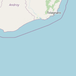
Map view of Andohahela National Park

Use this park location map to pinpoint Andohahela National Park in Madagascar, understand its exact geographic position, and read its mapped placement within the surrounding landscape more clearly.

Pigeon | © OpenStreetMap contributors

Location context for Andohahela National Park

Anosy
Park atlas

Browse the diverse protected landscapes of Madagascar, tracing the geographic spread of parks adjacent to Andohahela.

Explore Other National Parks and Protected Areas Near Andohahela National Park
After exploring Andohahela National Park's unique rainforest and spiny forest habitats, discover other national parks and protected areas across Madagascar's Anosy region. Compare their distinct ecological zones, lemur biodiversity, and varied mountain terrain, tracing the broader conservation landscape of southeastern Madagascar.
National parkAtsimo-Atsinanana

Midongy du sud National Park: National Park in Atsimo-Atsinanana, Madagascar

Explore its protected landscape and mapped geography.

Midongy du sud National Park is a significant protected area located in the Atsimo-Atsinanana region of Madagascar. This entry provides detailed geographic context, focusing on the park's mapped boundaries and its identity as a national park. It supports atlas-based discovery by offering insights into the park's specific landscape and its regional setting within southeastern Madagascar, serving as a factual resource for understanding its protected status.

Area
1,922 km²
Established
1997
IUCN
II
Relief
Mountain
Marine protected areaAtsimo-Andrefana

Nosy Ve-Androka National Park Marine Protected Area: Geographic and Atlas Discovery

Understand its marine landscape and regional geographic context.

Delve into Nosy Ve-Androka National Park, a critical marine protected area located in Madagascar's Atsimo-Andrefana region. This park offers a focused look at protected marine geography, allowing for detailed atlas exploration of its mapped boundaries and its role within the surrounding natural landscapes. Understand the specific geographic identity and conservation significance of this vital protected area through structured data.

Area
914.45 km²
Climate
Tropical
Access
Moderate access
Water
Water-dominated
National parkIhorombe Region

Isalo National Park: Explore Madagascar's Sandstone Canyons and Protected Landscape Geography

Discover unique geology, tapia woodlands, and regional park context.

Isalo National Park is a prominent protected area in Madagascar's Ihorombe Region, celebrated for its spectacular sandstone landscape. This national park features deep canyons, eroded rock domes, and striking runiform mountains, formed from ancient sedimentary deposits. The park preserves significant tapia woodlands and remarkable plant endemism, offering a rich context for understanding protected land distribution and Madagascar's unique geography. Its mapped terrain provides a visual atlas of natural wonders.

Area
815.4 km²
Established
1962
IUCN
II
Visitors
32.7K annual
National parkHaute Matsiatra

Andringitra National Park: A Protected Landscape within Haute Matsiatra's Geography

Explore mapped park boundaries and regional terrain.

Andringitra National Park represents a vital protected area within the Haute Matsiatra region, contributing significantly to the mapped landscape of central Madagascar. Its designation as a national park underscores its importance for conservation and geographic study. Users exploring this destination can gain a detailed understanding of its specific protected boundaries, the surrounding natural terrain, and its overall contribution to the regional geography, making it a key site for atlas-based landscape discovery.

Area
311.6 km²
Established
1999
IUCN
II
Visitors
3.4K annual
National parkAtsimo-Andrefana

Zombitse-Vohibasia National Park: Protected Landscape and Regional Geographic Context

Mapped protected areas and natural terrain discovery.

Investigate Zombitse-Vohibasia National Park, a designated national park within the Atsimo-Andrefana region. This dedicated entry provides detailed geographic information, focusing on the park's mapped terrain and its contribution to the regional protected landscape. Gain insight into the park's atlas-relevant features and its specific place within Madagascar's conservation geography.

Area
363.08 km²
Established
2002
IUCN
II
Relief
Upland
National parkMadagascar

Ranomafana National Park: Madagascar's premier Tropical Rainforest Protected Area

Explore its unique mapped geography and landscape context.

Ranomafana National Park stands as a crucial national park within Madagascar's protected lands, safeguarding a significant expanse of tropical rainforest. This page offers a deep dive into its geographic setting, detailing the mapped boundaries and the distinctive natural terrain that supports its exceptional biodiversity. Discover the atlas value of this protected landscape for understanding regional conservation and geographic context.

Area
416 km²
Established
1991
IUCN
II
Climate
Tropical
National parkMadagascar

Kirindy Mitea National Park: Madagascar National Park with Distinct Protected Landscape Identity

Explore the mapped geographic context of Kirindy Mitea National Park.

Kirindy Mitea National Park serves as a notable protected area, holding national park status within Madagascar's distinctive island geography. This entry focuses on understanding the park's unique protected landscape and its charted boundaries, offering essential context for atlas-driven exploration. Discover the geographic elements that define Kirindy Mitea National Park and its place within the broader conservation map of the region.

Area
1,563.5 km²
Established
1997
IUCN
IV
Relief
Mixed relief
National parkMadagascar

Marolambo National Park: Madagascar's National Park and Protected Landscape

Explore mapped boundaries and regional geography.

Marolambo National Park stands as a protected national park within Madagascar's globally recognized biodiversity hotspot. This entry provides focused insight into its protected landscape, its specific geographic context within the island nation, and its role in the conservation of unique natural terrain. Understanding Marolambo National Park through its mapped boundaries and regional geography contributes to a broader atlas exploration of Madagascar's endemic ecosystems.

Area
950.63 km²
Climate
Tropical
Access
Remote access
Scope
Terrestrial

Common questions about visiting, size, designation, and location context for Andohahela National Park

Andohahela National Park FAQs for park facts, access, geography, and protected area context
Find quick answers about Andohahela National Park, including protected-area facts, park geography, trail and visitor context, and how the park fits into its surrounding country and regional landscape.
MoriAtlas Explorer

Continue Your Protected Areas Search Across the Global Atlas

Deepen your exploration by continuing the structured search for national parks and protected areas worldwide. Utilize the comprehensive filtering capabilities to compare different conservation landscapes and refine your understanding of global park geography. Discover more about the distribution and characteristics of protected natural areas.

Global natural geography
Andohahela National Park: Madagascar National Park Map & Protected Area