Mori Atlas logo
National parkAnshi National Park

Explore the mapped boundaries and regional context of this Indian national park.

Anshi National Park India: Protected Landscape and Geographic Identity

Anshi National Park represents a key protected landscape within India, offering rich geographic context for atlas exploration. As a designated national park, it provides vital insights into the mapped terrain and protected area distribution across the subcontinent. Understanding Anshi National Park's specific geographic identity is crucial for a comprehensive grasp of India's conservation landscapes and regional geography.

tiger reserveWestern Ghatsnational park Karnatakaevergreen forestblack panther

Anshi National Park

National park

Park overview

Structured park overview, official facts, and landscape profile for Anshi National Park

Anshi National Park park facts, protected area profile, and essential visitor context

Review the core facts for Anshi National Park, including designation, size, terrain, visitor scale, habitats, and operating context in one park-focused overview.

About Anshi National Park

Anshi National Park represents a critical conservation landscape within the Western Ghats, one of the world's eight biodiversity hotspots. Located in Uttara Kannada district of Karnataka, the park protects some of the most intact forest ecosystems in the region. The landscape features undulating terrain with steep valleys and dense canopy cover, characteristic of the North Western Ghats montane rain forests. The Kali River traverses the reserve, serving as the ecological lifeline that sustains the intricate web of life within this protected area. The park's integration with Dandeli Wildlife Sanctuary created a unified conservation unit that provides sanctuary to large mammals including tigers, elephants, and the elusive black panther. Beyond its ecological significance, the area supports local communities whose livelihoods are intertwined with the forest resources, and the reserve offers nature trails, bird watching opportunities, and wildlife viewing experiences.

Quick facts and research context for Anshi National Park

Anshi National Park is situated in the Western Ghats of Karnataka at elevations ranging from 27 to 1,059 meters above sea level. The park forms part of a larger contiguous protected area network spanning over 2,200 square kilometers that includes adjacent reserves in Goa and Maharashtra. The ecosystem is characterized by North Western Ghats montane rain forests and North Western Ghats moist deciduous forests, both classified as endangered by WWF. The park contains remarkable biodiversity including black panthers, elephants, tigers, and approximately 200 bird species such as the great hornbill and Malabar pied hornbill.

Protection and recognition

Documenting the official protection scope, designation framework, and management boundaries.

Anshi National Park Protected Area Designation and Recognition Status

Users can browse the documented protection status, designation history, and legal management scope associated with Anshi National Park. Accessing verified global data helps establish a reliable geographic foundation for understanding regional conservation frameworks and management boundaries.

Protection details

Protection scope
Mixed
Park context

Deeper park guide and search-rich context for Anshi National Park

Anshi National Park history, landscape, wildlife, and travel context

Explore Anshi National Park through its history, landscape character, ecosystems, wildlife, conservation priorities, cultural context, and seasonal travel timing in a structured park guide built for atlas discovery and search intent.

Why Anshi National Park stands out

Anshi National Park is best known for its significant population of black panthers, a melanistic variant of leopards that are relatively rare across India but thrive in this dense forest habitat. The park is also notable for being part of one of the largest continuous protected forest landscapes in the Western Ghats, forming a near-uninterrupted ecological corridor spanning over 2,200 square kilometers across Karnataka, Goa, and Maharashtra. The presence of Bengal tigers, Indian elephants, and the diverse birdlife including several hornbill species further distinguishes this reserve within India's protected area network.

Anshi National Park history and protected-area timeline

Anshi National Park traces its origins to the declaration of the Dandeli Wildlife Sanctuary on May 10, 1956, which provided initial protection to the region's forest resources. The state government subsequently proposed carving out a section of the sanctuary to establish a dedicated national park, a plan that materialized on September 2, 1987, when Anshi National Park was officially created with an initial area of approximately 250 square kilometers. The final notification issued in 2002 expanded the park by an additional 90 square kilometers. In January 2007, Anshi National Park together with the Dandeli Wildlife Sanctuary received Project Tiger status and was declared the Anshi Dandeli Tiger Reserve, creating a unified management framework for the combined 1,300-square-kilometer landscape. The reserve was renamed Kali Tiger Reserve in December 2015, adopting the name of the river that flows through its heart. This renaming was partly influenced by the release of a film called Kali that highlighted the river's ecological importance.

Anshi National Park landscape and geographic character

The terrain of Anshi National Park is characterized by the undulating hills and valleys typical of the Western Ghats, with elevation ranging from 27 meters in the river valleys to 1,059 meters at higher points. The landscape features dense forest cover with semi-evergreen and evergreen vegetation dominating the slopes and valleys. The laterite soil composition across much of the reserve has low water retention capacity, meaning that despite the high annual rainfall, water holes often dry out early in the summer season. The Kali River and its tributaries carve through the forest, creating riparian corridors that support distinct ecological communities. The landscape includes rocky outcrops, steep cliffs, and seasonal streams that contribute to the visual and ecological diversity of the reserve.

Anshi National Park ecosystems, habitats, and plant life

The ecological character of Anshi National Park is defined by two critically endangered ecoregions: North Western Ghats montane rain forests and North Western Ghats moist deciduous forests. These forests support exceptional biodiversity, with the canopy reaching heights that create a layered environment supporting diverse flora and fauna. The park's vegetation includes species such as bintangur, Malabar tamarind, hopea ponga, blackboard tree, and various bamboo species. The forest structure varies from dense evergreen formations in the valleys to semi-deciduous associations on the ridges. This habitat heterogeneity supports the diverse wildlife assemblages found within the reserve.

Anshi National Park wildlife and species highlights

Anshi National Park provides habitat for several flagship species including Bengal tigers, black panthers, and Indian elephants. The black panther, a melanistic variant of the leopard, is particularly notable and draws attention due to its relative rarity. Large mammals found in the park include Indian bison (gaur), sloth bear, wild boar, and various deer species such as sambar, spotted deer (chital), barking deer, and mouse deer. Primates include bonnet macaques and northern plains grey langurs, while smaller mammals include jungle cats, leopard cats, Indian grey mongoose, flying squirrels, porcupines, and the endangered Malabar civet. The park supports nearly 200 bird species, with hornbills being particularly prominent: the great hornbill, Malabar pied hornbill, Malabar grey hornbill, and Indian grey hornbill all inhabit the forest canopies. Reptiles include king cobras, spectacled cobras, pythons, and various viper species.

Anshi National Park conservation status and protection priorities

Anshi National Park contributes significantly to conservation within the Western Ghats biodiversity hotspot, protecting endangered forest ecoregions and providing crucial habitat for large carnivores and megafauna. The integration of the park with Dandeli Wildlife Sanctuary created a larger, more ecologically viable conservation unit capable of supporting viable populations of apex predators like tigers. The forest ecosystems here play important roles in watershed protection, carbon sequestration, and maintenance of biodiversity corridors connecting isolated protected areas. The designation as a Project Tiger reserve brought additional funding and management attention to the area. Both the montane rain forests and moist deciduous forests are classified as endangered by WWF, highlighting the conservation urgency of protecting these remaining forest patches.

Anshi National Park cultural meaning and human context

The region surrounding Anshi National Park is inhabited by communities whose relationship with the land predates formal protection. The area is part of Uttara Kannada district, where the local population primarily speaks Kannada. Traditional agricultural practices, collection of forest products, and small-scale livelihoods have historically shaped human-forest interactions in the region. The naming of the reserve after the Kali River reflects the river's significance to local communities, as it serves as a vital water source for irrigation and domestic use across Uttara Kannada district.

Top sights and standout views in Anshi National Park

The most distinctive features of Anshi National Park include its population of black panthers, its position within one of the largest contiguous protected forest landscapes in the Western Ghats, and its diverse birdlife featuring multiple hornbill species. The park's location in the North Western Ghats provides access to endangered forest ecosystems that support tigers, elephants, and numerous endemic species. The landscape offers opportunities for wildlife viewing, birdwatching, and nature trails through diverse habitats.

Best time to visit Anshi National Park

The optimal visiting period for Anshi National Park spans from October to May, with the park operational from 6:00 AM to 6:00 PM. The monsoon season from June to September brings heavy rainfall to the Western Ghats, which while creating lush scenery, can restrict movement and wildlife viewing. The winter and summer months offer better opportunities for sighting animals as they frequent water holes. The climate remains quite humid throughout the year, and visitors should be prepared for variable conditions.

Monthly climate preview

Long term temperature and precipitation records measured at representative park coordinates

Anshi National Park Climate Normals and Annual Weather Patterns

Anshi National Park records long term average monthly temperatures ranging from 22.26 degrees Celsius to 28.72 degrees Celsius alongside distinct precipitation shifts across the year. Reviewing the complete twelve month climate profile provides deeper context for long term atmospheric conditions across the protected terrain.
Annual mean25 °C
22 °C29 °C
Jan23°
Feb25°
Mar27°
Apr29°
May28°
Jun26°
Jul25°
Aug24°
Sep25°
Oct25°
Nov23°
Dec22°
Warmest month
April

28.7 °C

Coolest month
December

22.3 °C

Wettest month
July

20.4 mm/day

Driest month
January

0 mm/day

Park location guide

Geography guide, regional context, and park location map for Anshi National Park

Anshi National Park park geography, regions, and map view in India

Understand where Anshi National Park sits in India through a broader geographic reading of the surrounding landscape, nearby location context, and its mapped position within the national park landscape.

How Anshi National Park fits into India

India is a South Asian country bordered by the Indian Ocean, Arabian Sea, and Bay of Bengal. It shares land borders with Pakistan, China, Nepal, Bhutan, Bangladesh, and Myanmar. The country has a population of over 1.4 billion people and operates as a federal parliamentary republic with its capital in New Delhi.

Wider geography shaping Anshi National Park in India

India occupies the Indian subcontinent in South Asia, bordered by the Arabian Sea to the southwest, the Bay of Bengal to the southeast, and the Indian Ocean to the south. It shares land borders with Pakistan to the west, China, Nepal, and Bhutan to the north, and Bangladesh and Myanmar to the east. The territory also includes the Andaman and Nicobar Islands in the Indian Ocean.

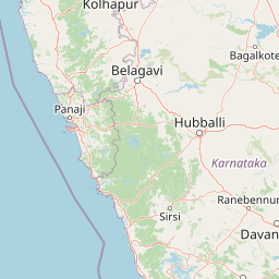
Map view of Anshi National Park

Use this park location map to pinpoint Anshi National Park in India, understand its exact geographic position, and read its mapped placement within the surrounding landscape more clearly.

Pigeon | © OpenStreetMap contributors

Location context for Anshi National Park

Karnataka
Park atlas

Browse surrounding protected landscapes and expand your atlas view of the contiguous Western Ghats region in India.

Discover National Parks and Protected Areas Near Anshi National Park in the Western Ghats

Explore national parks and protected areas surrounding Anshi National Park, tracing the regional forest ecosystems of the Western Ghats. Compare their mapped geography, conservation status, and protected landscapes to understand the broader ecological corridors and biodiversity hotspots across the region.
Wildlife reserveGoa
About 38 km away#1 closest

Northwest

Nanda Lake Wildlife Reserve: Wetland Geography and Protected Landscapes in Goa, India

A Ramsar-designated freshwater refuge in the Western Ghats foothills

Nanda Lake stands as a compact yet ecologically significant freshwater wetland in Goa. Recognized under the Ramsar Convention, this wildlife reserve preserves a rare piece of the Konkan coast's natural freshwater terrain, providing essential habitat for migratory birds and native aquatic species within a heavily human-influenced regional landscape.

Area
0.42 km²
Established
2022
Relief
Lowland
Water
Water-dominated
National parkIndia
About 42 km away#2 closest

North

Mollem National Park National Park: Geographic Context and Protected Landscape Exploration in India

Discover mapped terrain and biodiversity within the Western Ghats.

Delve into the specifics of Mollem National Park, a protected area renowned for its spectacular Dudhsagar Falls and the historic Tambdi Surla Mahadev Temple. This page provides detailed geographic context, showcasing the park's steep, forested slopes and its significance as part of the Western Ghats biodiversity hotspot. Understand the park's unique landscape, from its role as a critical watershed to its function as a habitat for diverse flora and fauna, offering rich material for atlas exploration and geographic appreciation of this Indian natural landmark.

IUCN
II
Nature reserveKarnataka
About 123 km away#3 closest

East

Magadi Bird Sanctuary: A Key Wetland Nature Reserve in Karnataka, India

Mapped inland wetland and migratory bird sanctuary

Magadi Bird Sanctuary is a significant protected wetland nature reserve situated within the agricultural terrain of Karnataka. Known for the Magadi tank, this site provides a vital refuge for migratory waterbirds in the dry interior region, balancing active rural land use with essential biodiversity conservation across its catchment area.

Area
0.543 km²
Relief
Lowland
Access
Access unknown
Scope
Terrestrial
Watercolor painting showing a landscape with rolling hills, forests, and distant mountains
National parkKarnataka
About 187 km away#4 closest

Southeast

Kudremukh National Park: Karnataka's Protected Landscape and River Origin

Explore the geography of shola forests and grasslands.

Kudremukh National Park is a pivotal protected landscape in Karnataka, India, recognized for its distinctive montane grasslands and shola forests. This national park is a critical source for three major rivers: the Tunga, Bhadra, and Nethravathi, highlighting its ecological and geographic significance within the Western Ghats. The park's terrain features rolling hills and steep western slopes, contributing to its unique biodiversity and landscape character for atlas-based discovery.

Area
600.57 km²
Established
1987
IUCN
II
Relief
Mountain
National parkIndia
About 249 km away#5 closest

North

Chandoli National Park: A National Park within India's Protected Lands Atlas

Mapped boundaries and regional landscape context for this protected area.

Chandoli National Park represents a distinct protected area within India, offering specific insights into national park landscapes and their geographic distribution. This entry focuses on its identity as a national park, detailing its mapped boundaries and regional context. It serves as a critical point for understanding the park's landscape within the atlas, providing factual geographic information for exploration and comparative study.

Area
317.67 km²
Established
2004
IUCN
II
Relief
Mountain
National parkKarnataka
About 379 km away#6 closest

Southeast

Nagarahole National Park: National Park within Karnataka's Protected Geography

Explore mapped boundaries and regional landscape context.

Nagarahole National Park stands as a distinct national park entity within the state of Karnataka, India. This section focuses on its specific geographic footprint and the protected landscape it encompasses, offering valuable data for users engaged in atlas-based discovery of India's conservation areas and natural terrains. Understand its mapped geography and regional significance.

Area
847.98 km²
Established
1983
IUCN
II
Relief
Upland
National parkKarnataka
About 396 km away#7 closest

Southeast

Bandipur National Park: Karnataka's Protected Landscape and National Park Atlas Entry

Discover mapped terrain and diverse forest ecosystems in South India.

Bandipur National Park, a prominent national park within Karnataka, serves as a vital hub for understanding protected area geography and landscape diversity. Its ecological significance is amplified by its location at the intersection of the Deccan Plateau and the Western Ghats, supporting a unique blend of forest types and rich biodiversity. This entry provides essential context for atlas-based discovery, detailing the park's mapped terrain, its role as a tiger reserve, and its contribution to the Nilgiri Biosphere Reserve's conservation landscape.

Area
1,456.3 km²
Established
1973
IUCN
II
Relief
Mixed relief
Watercolor illustration showing mountains, a winding river, and green vegetation
National parkKarnataka
About 423 km away#8 closest

Southeast

Bannerghatta National Park: A National Park in Karnataka with Mapped Geographic Identity

Explore the protected landscape and regional terrain context.

Bannerghatta National Park is an important protected area within the state of Karnataka, India. Its designation as a national park signifies its role in preserving regional natural landscapes and providing valuable geographic context for atlas exploration. Users can examine its mapped boundaries and understand its placement within the diverse terrain characteristic of South India and the Western Ghats, contributing to a structured understanding of protected lands.

Area
260.51 km²
Established
1974
IUCN
II
Relief
Mountain

Common questions about visiting, size, designation, and location context for Anshi National Park

Anshi National Park FAQs for park facts, access, geography, and protected area context

Find quick answers about Anshi National Park, including protected-area facts, park geography, trail and visitor context, and how the park fits into its surrounding country and regional landscape.
MoriAtlas Explorer

Continue Your Protected Areas Search Across the Global Atlas

Deepen your exploration by continuing the structured search for national parks and protected areas worldwide. Utilize the comprehensive filtering capabilities to compare different conservation landscapes and refine your understanding of global park geography. Discover more about the distribution and characteristics of protected natural areas.

Global natural geography
Anshi National Park India: Protected Area Map & Geography