
Mori Atlas logo
National parkAnyuysky National Park

A vast, intact wilderness spanning the Anyui River valley and Amur basin ecosystems.

Anyuysky National Park: Protected Forest Landscapes and Sikhote-Alin Mountain Geography

Anyuysky National Park preserves one of the most ecologically undisturbed sections of the central Sikhote-Alin mountain range. This protected area features a unique transition zone where broadleaf forests merge with dark coniferous taiga. Beyond the dense riverine corridors and Korean cedar stands, the park is defined by the striking Nadge rock formations, which tower over the landscape as weathered sandstone pillars. The terrain reflects a complex interplay between mountainous ridges and the lowland influence of the Amur River basin.

sikhote-alinmountain forestsbroadleaf forestconiferous taigakorean cedaramur river basin

Anyuysky National Park

National park

Park overview

Structured park overview, official facts, and landscape profile for Anyuysky National Park

Anyuysky National Park park facts, protected area profile, and essential visitor context

Review the core facts for Anyuysky National Park, including designation, size, terrain, visitor scale, habitats, and operating context in one park-focused overview.

About Anyuysky National Park

Anyuysky National Park occupies a substantial block of the Sikhote-Alin mountain system in the lower basin of the Anyui River, just before it joins the Amur. Its setting along the right bank of the Amur places it firmly within the geographic heart of the Russian Far East, and the surrounding landscape combines forested ridges, river valleys, and rocky outcrops that together create a continuous, well-connected natural environment.

The vegetation pattern is one of the park's most distinctive features. Unlike many areas of the Sikhote-Alin that have been logged or disturbed, Anyuysky retains a complex mosaic of broadleaf stands and dark coniferous taiga, with Korean cedar forming a major share of the canopy. This mix is typical of the southern and middle Sikhote-Alin and supports a correspondingly rich understory and animal community. The relative absence of roads and settlements inside the core area makes the park one of the more intact forest landscapes in the region.

The park's geography is tied closely to water. The Anyui River runs through it from higher in the mountains down to the Amur, and the riverside lowlands along with the mid-elevation slopes create a layered habitat structure, from riparian vegetation near the rivers to cedar and broadleaf forest higher up. The famous Nadge rocks, often called the Anyui Pillars, rise above this forested valley as a band of ruin-like sandstone formations that local communities traditionally associated with shamanic stories.

Because Anyuysky is a relatively young national park, having been formally established in late 2007, much of its current identity centers on landscape and wildlife conservation rather than a long history of tourism development. The park is managed from Troitskoye, and there is a single settlement within its boundaries, the village of Verkhnyaya Manoma. Despite its ecological importance, the park remains one of the more remote and least publicised protected areas in Khabarovsk Krai.

Quick facts and research context for Anyuysky National Park

Anyuysky National Park covers an area of approximately 4,293 square kilometers in Khabarovsk Krai, in the Nanaysky District along the Amur River. It was established on December 15, 2007 and is managed by a dedicated federal state institution headquartered in the village of Troitskoye.

The park protects a section of the Sikhote-Alin mountains in the lower Anyui River basin, where forests include both broadleaf stands and dark coniferous taiga dominated by Korean cedar. Its relative isolation has supported stable populations of brown and Himalayan bears, Siberian deer, and several regionally significant bird species. The western and northern boundaries of the park run along the R454 federal highway connecting Khabarovsk to Komsomolsk-on-Amur and onward toward Lidoga and Vanino.

Protection and recognition

Examine the terrestrial protection scope and documented designation metrics for Anyuysky National Park.

Anyuysky National Park Protection Status and Conservation Recognition

Anyuysky National Park maintains a defined terrestrial protection scope within its regional conservation boundary. Structured tracking records outline the established designation framework and administrative parameters governing the protected landscape.

Protection details

Protection scope
Terrestrial
Transboundary protection
No
Park context

Deeper park guide and search-rich context for Anyuysky National Park

Anyuysky National Park history, landscape, wildlife, and travel context

Explore Anyuysky National Park through its history, landscape character, ecosystems, wildlife, conservation priorities, cultural context, and seasonal travel timing in a structured park guide built for atlas discovery and search intent.

Why Anyuysky National Park stands out

Anyuysky is best known for protecting one of the least human-disturbed sections of the central Sikhote-Alin range, where broadleaf and dark coniferous forests still blend along the Anyui River valley. The park is also associated with the dramatic Nadge rock formations, locally known as the Anyui Pillars, a line of weathered sandstone crests along the river that have become a signature landscape feature. Wildlife is another defining element of the park's identity: brown and Himalayan bears, wild boar, and Manchurian wapiti share the same forests with rare species like Blakiston's fish owl and the mandarin duck, giving Anyuysky a strongly East Asian ecological character.
Anyuysky National Park history and protected-area timeline

Anyuysky National Park was formally established on December 15, 2007 as part of the Russian Federation's program of expanding its protected-area network across the Far East. The site was chosen for its unusually intact forest cover and the limited degree of human modification across the local Sikhote-Alin ridges and Anyui River valley.

The federal state institution responsible for managing the park was created on March 13, 2009, giving the reserve its operational administrative structure. Park administration is based in the village of Troitskoye in the Nanaysky District, while the only settlement within the park's own boundaries remains the small village of Verkhnyaya Manoma.

A long-standing cultural reference for the area comes from the early twentieth-century explorer Vladimir Arsenyev, who described the dramatic rock formations along the Anyui in his account of travel through the Sikhote-Alin, recording local traditions that viewed the eroded pillars as sites of ancient shamanic significance.

Anyuysky National Park landscape and geographic character

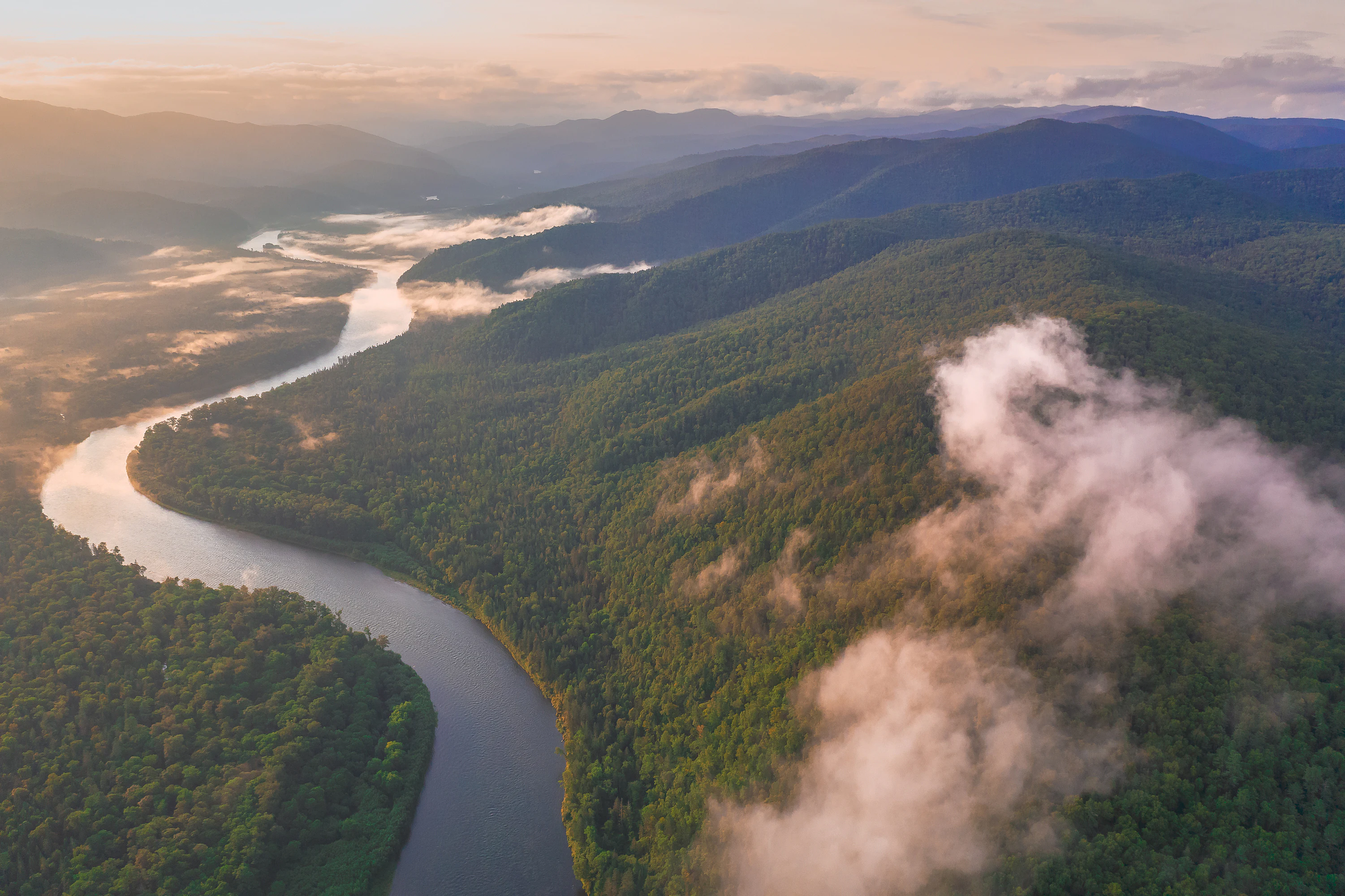
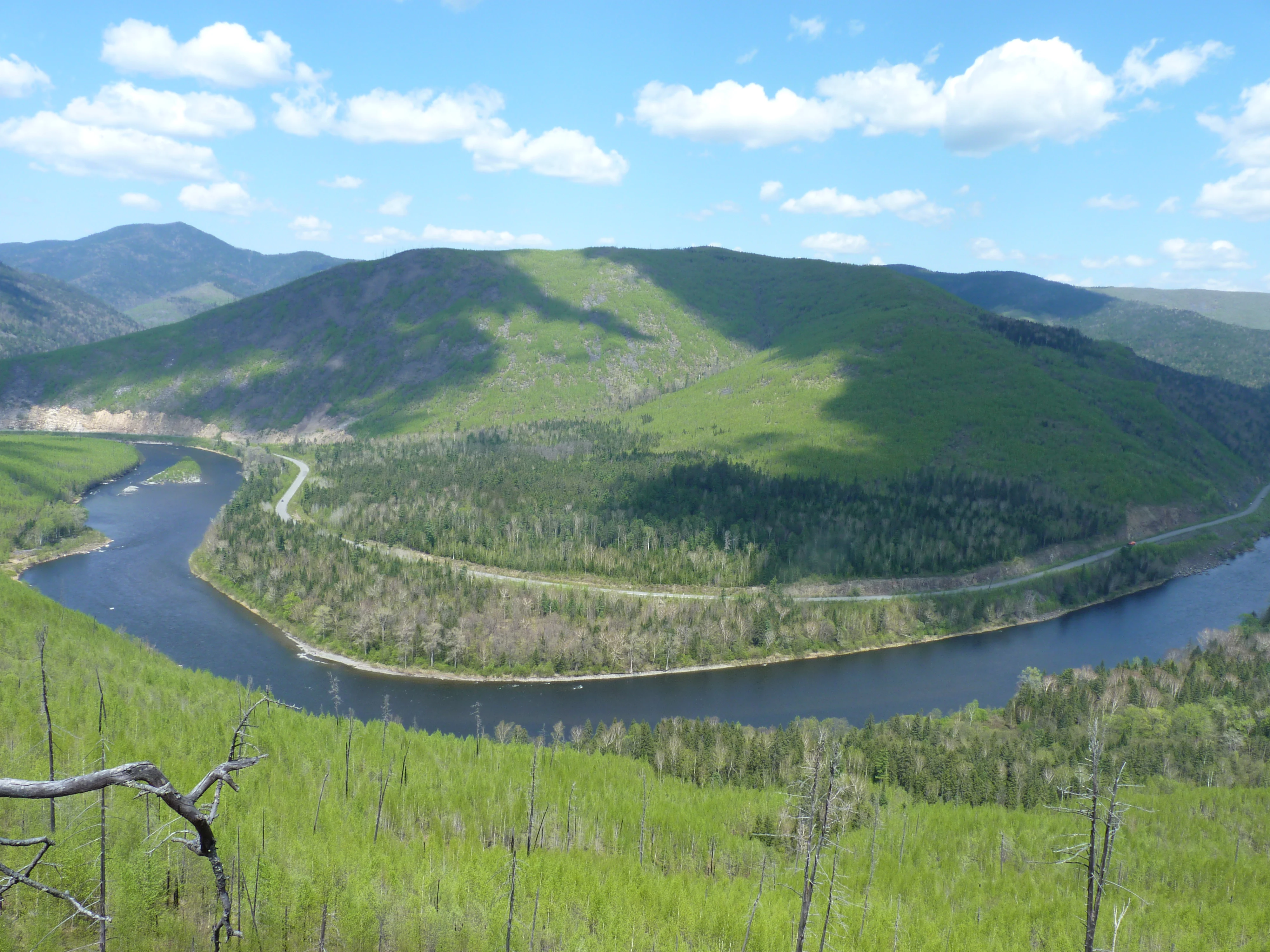
The landscape of Anyuysky National Park is defined by the central Sikhote-Alin mountains as they descend toward the Amur River. Forested ridges, river valleys, and exposed rocky crests combine to form a varied terrain, with the Anyui River corridor acting as the main organizing feature of the park. Elevation drops from the uplands of the range down to the lowland Amur floodplain, creating a layered topography of slopes, benches, and valley floors.

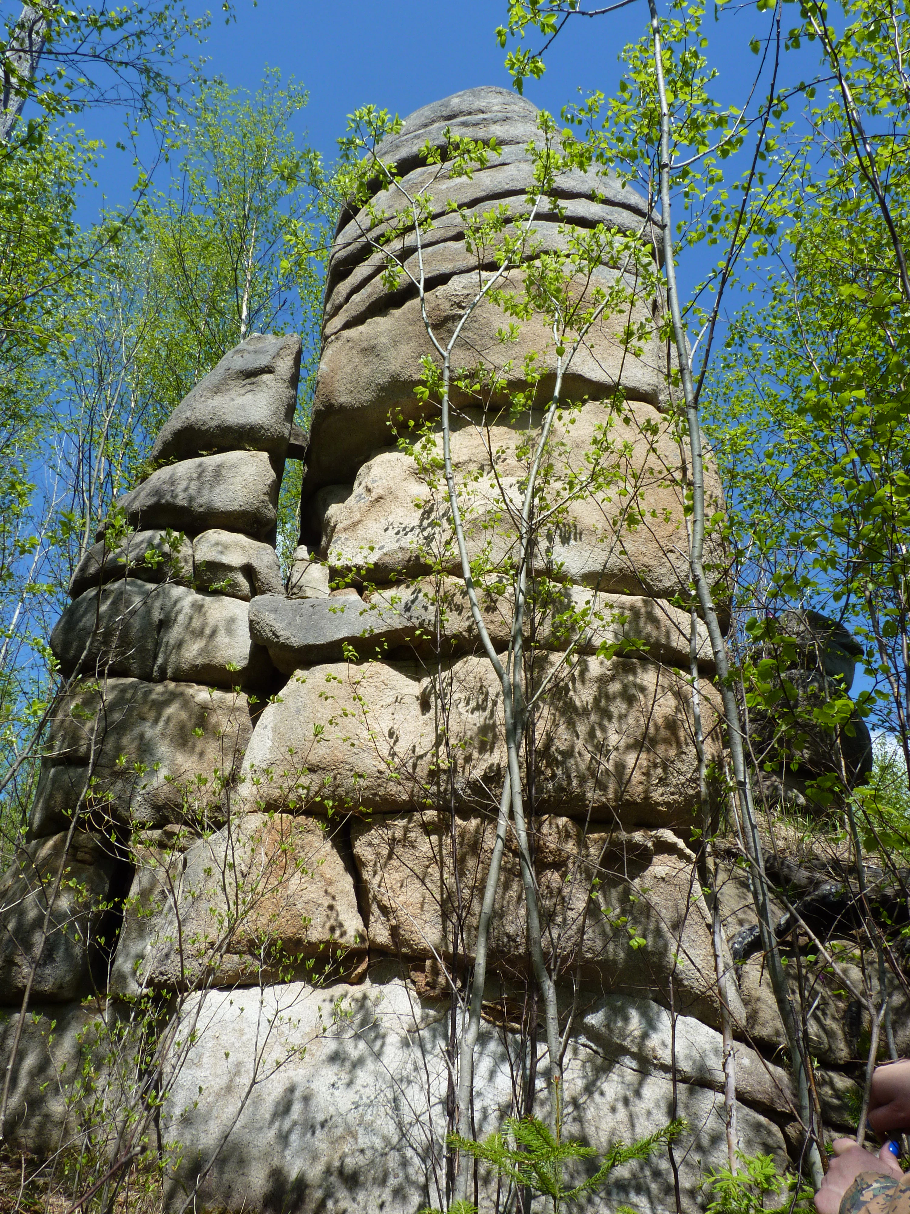
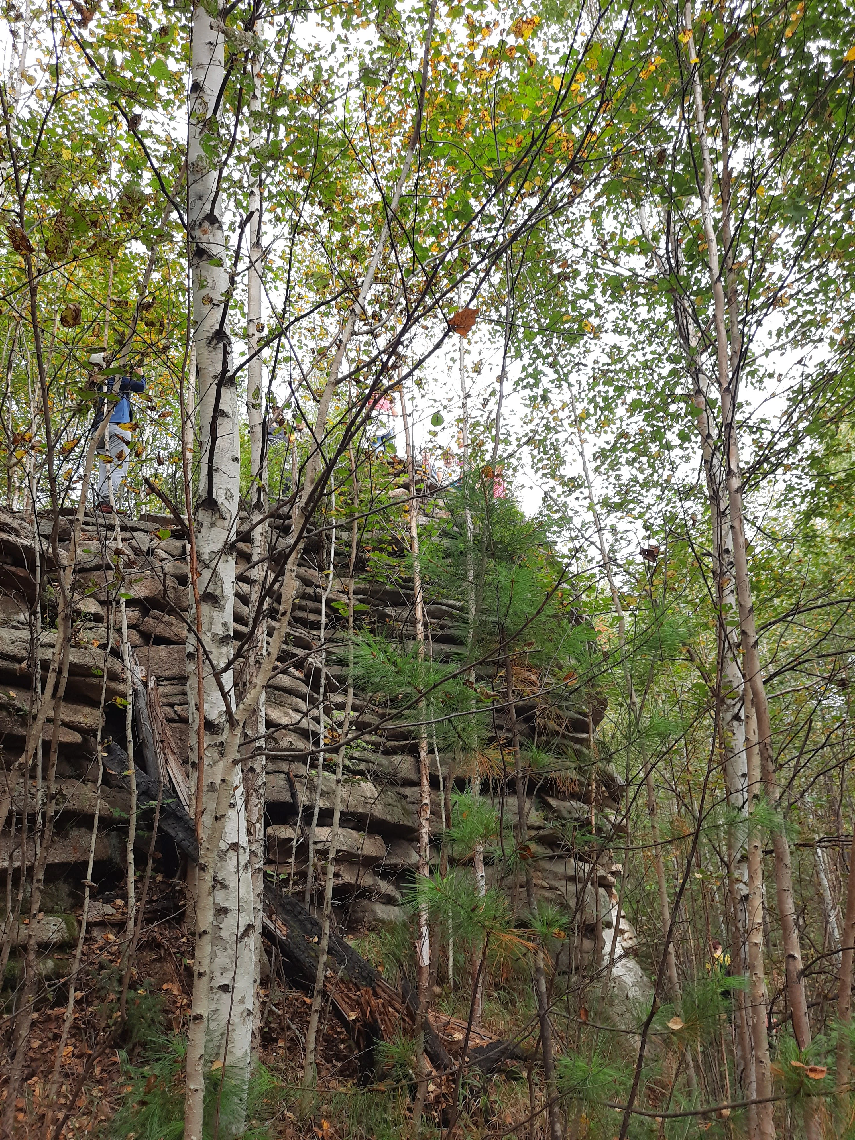
The most visually distinctive landscape element is the line of sandstone formations known as the Nadge rocks, also referred to as the Anyui Pillars. Sitting above the forested Anyui valley, they present a striking silhouette of weathered columns and pinnacles, locally associated with shamanic legend and described by early explorers as resembling ruined ancient fortresses. Below these formations, the river winds through dense forest, while the foothills and lower slopes rise back up into rolling, tree-covered ridges.

The hydrological setting also shapes the park's surface character. Streams flowing from the Sikhote-Alin peaks feed the Anyui and contribute to broad riparian zones, and the proximity to the Amur adds a lowland influence near the park's southern boundary. Together these features create a landscape that is at once mountainous, riverine, and forest-covered, with limited evidence of large-scale human modification.
Anyuysky National Park ecosystems, habitats, and plant life

Anyuysky protects a transition between two major forest types of the southern and central Far East: broadleaf forest and dark coniferous taiga. Korean cedar is a defining species of the coniferous component, giving the upper canopy a distinctive East Asian character, while broadleaf species contribute to a layered structure beneath and alongside the conifers. This forest mosaic is one of the defining ecological features of the park and a key reason it was designated for protection.

The vegetation patterns reflect both elevation and proximity to the Amur. Lower elevations and river corridors support humid broadleaf and mixed stands, while slopes and higher terrain increasingly favor coniferous dominance. Because the park lies at the boundary between these forest zones, it preserves an unusually complete gradient from riverside vegetation to upland taiga in a relatively compact area.

The combination of intact forest, varied topography, and limited human disturbance supports a stable and diverse animal community, including large mammals such as brown bears and Himalayan bears, as well as regionally rare birds and insects characteristic of the Amur region.
Anyuysky National Park wildlife and species highlights

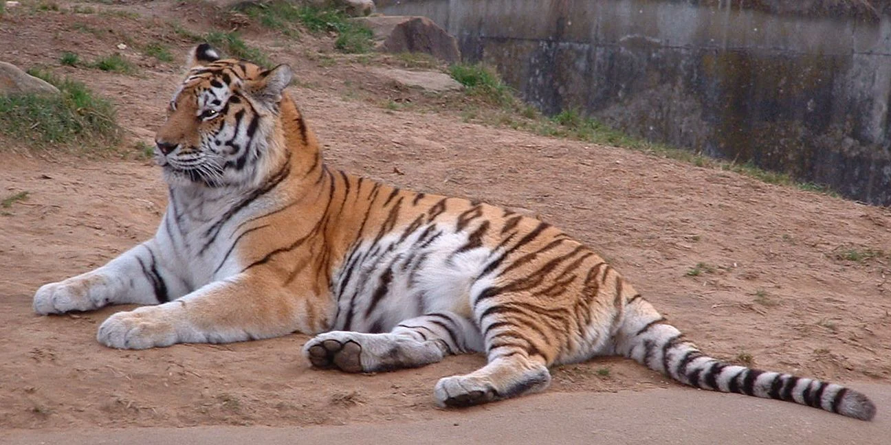
Anyuysky's wildlife reflects the meeting of northern taiga and East Asian broadleaf forest influences. Brown bears and Himalayan bears both occur within the park, sometimes sharing overlapping ranges, and the area supports populations of wild boar and Manchurian wapiti, also known as izyubr. These species together indicate a functional, mammal-rich forest ecosystem with both food and seasonal habitat resources intact.

The bird community is one of the most distinctive elements of the park. Blakiston's fish owl, a globally rare species associated with riverside forests of the Far East, has been recorded here, along with mandarin ducks along the forested watercourses. Reptiles and amphibians typical of the southern Far East also occur, including the Amur rat snake.

The park also supports a notable insect fauna, including several of the largest moth and butterfly species found in Russia. Species such as Schrenk's purple emperor, the Japanese oak silkmoth, and the red Japanese silkmoth are mentioned as occurring within the park, reflecting the intact mosaic of broadleaf and coniferous forest that supports such large Lepidoptera.
Anyuysky National Park conservation status and protection priorities

The primary conservation purpose of Anyuysky National Park is to protect one of the least-disturbed forest landscapes in the central Sikhote-Alin mountains. Because logging, road-building, and settlement expansion have altered much of the surrounding region, the park's relatively intact character gives it significance beyond its own boundaries as a reference area for what the regional forest once looked like.

The park also serves as a refuge for species that depend on continuous forest cover and clean river systems, including large carnivores, deer, and rare riparian birds such as Blakiston's fish owl. Its inclusion of both broadleaf and dark coniferous forest within a single protected unit helps preserve a greater range of microhabitats and seasonal resources than a narrower designation would.

The park's IUCN Category II designation reflects its status as a protected landscape managed primarily for ecosystem conservation and recreation. By combining ridge, slope, and riverside habitats within one boundary, Anyuysky helps maintain ecological connectivity in the lower Anyui basin, an important consideration for wide-ranging mammals and migratory bird populations connected to the wider Amur watershed.

Anyuysky National Park cultural meaning and human context

The cultural context of Anyuysky is closely tied to the indigenous Nanai communities and other peoples of the Amur valley who have long inhabited the lower Anyui region. Local oral traditions associate the eroded Nadge rock formations with shamanic beliefs, describing them as places once inhabited by winged spirits in older narratives of the area.

The early twentieth-century Russian explorer Vladimir Arsenyev, who traveled through the Sikhote-Alin, recorded these associations in his writings on the region, noting that local inhabitants referred to the formations as shamanic stones and embedded them in stories of a more mythic past. His descriptions remain one of the most widely cited cultural references for the landscape of the Anyui valley.

Today, the park's only permanent settlement is the small village of Verkhnyaya Manoma, which reflects the continuing human presence within an otherwise overwhelmingly natural landscape, and underscores the park's role in maintaining traditional land use alongside active conservation.
Top sights and standout views in Anyuysky National Park

Anyuysky stands out for the combination of an intact central Sikhote-Alin forest block, a strong population of large mammals including both brown and Himalayan bears, and the dramatic Nadge rock formations along the Anyui River. Its status as one of the least human-modified forests in Khabarovsk Krai makes it a key reference site for regional conservation.

Highlights of the park also include rare and emblematic species such as Blakiston's fish owl and the mandarin duck, alongside the Korean cedar-dominated dark coniferous taiga that gives the upper canopy its distinctive character. Together these features define a protected area that is unusually rich in both ecological and landscape value for the southern Russian Far East.

Best time to visit Anyuysky National Park

The character of a visit to Anyuysky is shaped heavily by the climate of the Amur region. Summer generally brings the most accessible conditions in the river valleys, when vegetation is fully leafed and wildlife is active across the forest slopes. This is also a productive period for observing mammals and watching riverside birdlife along the Anyui and smaller tributaries.

Late spring into early summer, when water levels on the Anyui are still high and broadleaf foliage is young and vivid, often produces the most visually striking scenery and is favorable for viewing species such as mandarin ducks along the forested watercourses. Autumn can also be rewarding, particularly for landscape photography, as the mixed broadleaf and coniferous forests shift color and the rocky formations above the valley become more visible against the forest backdrop.

Given the park's remote character, the lower Anyui basin, and the limited infrastructure beyond the peripheral R454 highway, weather and seasonal access strongly influence any on-the-ground experience, and visitors generally plan around the warmer months when rivers, forest trails, and viewpoints are most accessible.

Monthly climate preview

Long term monthly temperature and precipitation averages recorded at reference coordinates

Anyuysky National Park Climate Normals and Annual Temperature Rhythm

Anyuysky National Park exhibits measured monthly temperature values ranging from severe subzero winter minimums to warm summer maximums alongside varying precipitation rates. Reviewing the complete twelve month climate profile reveals full historical weather variations and detailed long term averages.
Annual mean1 °C
-23 °C22 °C
Jan-23°
Feb-18°
Mar-9°
Apr
May12°
Jun18°
Jul22°
Aug20°
Sep14°
Oct
Nov-9°
Dec-21°
Warmest month
July

21.6 °C

Coolest month
January

-22.9 °C

Wettest month
August

3.8 mm/day

Driest month
January

0.5 mm/day

Park location guide

Geography guide, regional context, and park location map for Anyuysky National Park

Anyuysky National Park park geography, regions, and map view in Russia

Understand where Anyuysky National Park sits in Russia through a broader geographic reading of the surrounding landscape, nearby location context, and its mapped position within the national park landscape.

How Anyuysky National Park fits into Russia

Russia is a transcontinental nation spanning eleven time zones, bordered by fourteen countries. It is the world's largest country by area, covering 17,098,246 km². Moscow is the capital and largest city, while Saint Petersburg is the second-largest and a major cultural centre.

Wider geography shaping Anyuysky National Park in Russia

Russia spans Eastern Europe and North Asia, covering 17,098,246 km². It shares land borders with fourteen countries, more than any other nation, and spans eleven time zones. The landscape includes vast plains, mountain ranges such as the Urals and Caucasus, and extensive coastlines along the Arctic Ocean, Pacific Ocean, Baltic Sea, Black Sea, and Caspian Sea.

Map view of Anyuysky National Park

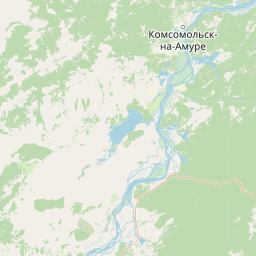
Use this park location map to pinpoint Anyuysky National Park in Russia, understand its exact geographic position, and read its mapped placement within the surrounding landscape more clearly.

Pigeon | © OpenStreetMap contributors

Location context for Anyuysky National Park

Khabarovsk Krai
Park atlas

Compare surrounding mountain forests and regional protected landscapes

Explore Parks Near Anyuysky National Park And Related Protected Areas

Continue exploring regional park geography by comparing adjacent protected areas near Anyuysky National Park. Reviewing these surrounding wilderness zones reveals shared forest ecosystems and mountain terrain across the broader Amur river basin.
Watercolor painting of a river flowing through green hills with pink flowering trees and distant mountains under a light sky
National parkKhabarovsk Krai
About 0 km away#1 closest

Southeast

Anyuysky National Park: Geographic and Protected Landscape Discovery in Khabarovsk Krai

Ecological corridors from the Amur River to the Sikhote-Alin mountains.

Anyuysky National Park represents a critical, remote expanse in the Russian Far East. Its boundaries protect a continuous gradient of habitats, linking the flat wetlands of the Amur River floodplain with the forested slopes of the Sikhote-Alin highlands. The park serves as a key area for habitat preservation and environmental mapping.

Area
4,294 km²
Established
1999
IUCN
II
Relief
Mixed relief
Watercolor painting showing a river flowing through a forested valley with mountains in the background
National parkPrimorsky Krai
About 241 km away#2 closest

South

Bikin National Park: Protected Landscapes and Geographic Boundaries in Primorsky Krai

Old-growth forest wilderness in the Sikhote-Alin range

Spanning over 1.16 million hectares, Bikin National Park protects one of the most biodiverse temperate forest ecosystems in the Northern Hemisphere. The mountainous terrain and the Bikin River basin provide essential habitats for rare wildlife, representing a world-class conservation landscape within the Russian Far East.

Area
11,600 km²
Established
2015
IUCN
II
Relief
Mountain
National parkPrimorsky Krai
About 312 km away#3 closest

South

Bikin National Park: Protected Landscape Map and Regional Geography in Primorsky Krai

A vast wilderness corridor in the Sikhote-Alin mountain range

Bikin National Park is a prominent protected area in Primorsky Krai, encompassing the Bikin River valley and surrounding mountain ridges. This wilderness preserve is integral to the survival of the Amur tiger and features a distinct mix of coniferous and broadleaf forest ecosystems. The geography highlights a transition between boreal and temperate forest zones, maintained as a largely untouched natural landscape within the Russian Far East.

Area
11,604.7 km²
Established
2015
IUCN
II
Relief
Mountain
Watercolor painting of a landscape featuring green forests, distant mountains, and a body of water in the foreground
National parkPrimorsky Krai
About 412 km away#4 closest

South

Udegeyskaya Legenda National Park: National Park with Mapped Protected Boundaries

Explore Protected Landscape Geography in Primorsky Krai

Gain an atlas-level understanding of Udegeyskaya Legenda National Park, a designated national park situated in Russia's Primorsky Krai. This resource provides insights into the park's geographic setting and the extent of its protected landscape. It is designed for users interested in the mapped features and regional context of protected natural areas, offering a clear view of the park's role within its geographic domain.

Area
1,037 km²
Established
2007
IUCN
II
Relief
Mountain
National parkHokkaido
About 591 km away#5 closest

Southeast

Rishiri-Rebun-Sarobetsu National Park: Volcanic Islands and Coastal Wetlands of Northern Hokkaido

Explore its mapped geography and unique subarctic alpine flora.

Rishiri-Rebun-Sarobetsu National Park in Hokkaido, Japan, offers a unique exploration of dramatic volcanic islands and vital coastal wetland ecosystems. This protected area showcases striking geological formations, from the conical peaks of Rishiri and Rebun islands to the vast peat bogs of the Sarobetsu Plain. Its subarctic environment supports a rich tapestry of alpine flora, providing a distinct case study in protected landscape geography and mapping for the region.

Area
241.66 km²
Established
1974
IUCN
II
Visitors
730K annual
National parkKhabarovsk Krai
About 622 km away#6 closest

North

Shantar Islands National Park: Remote Archipelago Atlas with Rugged Terrain

Mapping protected marine and island geography in Khabarovsk Krai.

Shantar Islands National Park represents a significant protected landscape within Khabarovsk Krai, notable for its dramatic coastal geography, mountainous terrain, and rich marine ecosystems. This national park, encompassing a chain of islands in the Sea of Okhotsk, is a vital habitat for marine mammals and seabird colonies. Explore its mapped boundaries and unique regional atlas context, understanding its role as a protected coastal area in the Russian Far East.

Area
5,155 km²
Established
2013
IUCN
II
Relief
Mountain
National parkPrimorsky Krai
About 674 km away#7 closest

South

Zov Tigra National Park: Regional Geography and Sikhote-Alin Protected Landscape Analysis

A core conservation area in the southern Russian Far East.

Zov Tigra National Park encompasses an essential segment of the Sikhote-Alin mountain range, featuring deep river gorges and soaring ridges that reach the highest elevations in Primorsky Krai. This protected expanse integrates diverse forest types and serves as a key habitat link for rare species. Our atlas data details the terrain, elevation gradients, and river corridors that define this significant Russian conservation zone.

Area
834.9 km²
Established
2007
IUCN
II
Relief
Mountain
Watercolor painting of a valley landscape with a river, hills, trees, and a sky with sunrise colors
National parkPrimorsky Krai
About 674 km away#8 closest

South

Zov Tigra National Park: Geography and Protected Wilderness of the Sikhote-Alin Range

A rugged mountain landscape and critical conservation area in Primorsky Krai.

Zov Tigra National Park features a dramatic, forest-covered terrain within the southern Sikhote-Alin mountains. With peaks rising to 1,854 meters and deep river canyons, this protected area serves as a cornerstone for wildlife recovery and ecological monitoring in the region. Explore the topographical characteristics of this unique mountain habitat and its position in the broader Primorsky Krai geography.

Area
834 km²
Established
2007
IUCN
II
Relief
Mountain

Common questions about visiting, size, designation, and location context for Anyuysky National Park

Anyuysky National Park FAQs for park facts, access, geography, and protected area context

Find quick answers about Anyuysky National Park, including protected-area facts, park geography, trail and visitor context, and how the park fits into its surrounding country and regional landscape.
MoriAtlas Explorer

Continue Your Protected Areas Search Across the Global Atlas

Deepen your exploration by continuing the structured search for national parks and protected areas worldwide. Utilize the comprehensive filtering capabilities to compare different conservation landscapes and refine your understanding of global park geography. Discover more about the distribution and characteristics of protected natural areas.

Global natural geography