

Mori Atlas logo
Nature reserveLaguna de Apoyo Nature Reserve

Examining the geological structure and tropical dry forest ecosystems within this protected basin.

Laguna de Apoyo Nature Reserve: An Atlas Study of Volcanic Caldera Landscapes and Protected Terrain in Nicaragua

Laguna de Apoyo Nature Reserve represents a critical protected area in western Nicaragua, defined by its origin within the caldera of an extinct volcano. This near-circular lake occupies a deep basin surrounded by steep, forested slopes, creating a unique hydrological environment that lacks surface outlets. The surrounding tropical dry forest provides essential habitat for endemic cichlid species and a high count of resident and migratory birds, offering a concentrated study of Central American volcanic geography.

volcanic lakecalderatropical dry forestendemic fishfreshwater biodiversitybirdwatching

Laguna de Apoyo Nature Reserve

Nature reserve

Park overview

Structured park overview, official facts, and landscape profile for Laguna de Apoyo Nature Reserve

Laguna de Apoyo Nature Reserve park facts, protected area profile, and essential visitor context

Review the core facts for Laguna de Apoyo Nature Reserve, including designation, size, terrain, visitor scale, habitats, and operating context in one park-focused overview.

About Laguna de Apoyo Nature Reserve

Laguna de Apoyo Nature Reserve is one of the most geologically distinctive protected areas in Nicaragua. At its core lies Laguna de Apoyo, a roughly circular lake that fills the caldera of an extinct volcano. The lake is endorheic, with no surface outlet, and depends on underground inflows and outflows to maintain its level. Its depth and the clarity of its water have made it a focal site for scientific research, recreational diving, and ecological study.

The reserve sits between the departments of Masaya and Granada in Nicaragua's Pacific region, not far from the city of Masaya. Its caldera walls rise above the surrounding lowlands, creating a sheltered basin that supports tropical dry forest vegetation. More than 500 plant species have been recorded within the reserve, including characteristic dry forest trees such as pochote, black rosewood, mahogany, and hogplum, alongside a notable abundance of orchids.

Ecologically, the reserve combines forested slopes, lakeshore habitats, and aquatic environments. Mammals typical of Central American dry forest, such as howler monkeys, white-faced capuchins, variegated squirrels, opossums, anteaters, pacas, and jaguarundis, occur in the area, along with reptiles including green iguanas and common boas. Birdlife is particularly rich, with more than 230 species documented, including oropendolas, falcons, hummingbirds, and dozens of migratory species, while butterflies and mollusks add substantial invertebrate diversity.

The lake itself harbors a small but scientifically important freshwater fauna. Six cichlid species in the genus Amphilophus are endemic to Laguna de Apoyo, with several only formally described in recent decades. A research station managed by the Nicaraguan NGO FUNDECI/GAIA, located on the lakeshore, has played a leading role in describing these species and tracking the lake's ecological condition.

Beyond its natural value, the reserve has become a recreational anchor for the region. Its dark volcanic sand beaches, calm waters, and scenic crater-rim viewpoints support swimming, kayaking, boating, hiking, scuba diving, birdwatching, and paragliding. Pumice stones from the lakebed are still harvested locally for use in the clothing industry, and recent discoveries of petroglyphs and artifacts have pointed to a deeper indigenous presence within the caldera landscape. Together, the reserve's volcanic setting, regulated management, and diverse habitats give it a strong profile among Nicaragua's protected areas.

Quick facts and research context for Laguna de Apoyo Nature Reserve

Laguna de Apoyo Nature Reserve protects a volcanic caldera lake and its drainage basin in the Pacific lowlands of Nicaragua, between the departments of Masaya and Granada. It is classified as a nature reserve under Nicaragua's protected areas system and is overseen by the Ministry of the Environment and Natural Resources. The lake is endorheic and unusually deep, occupying the crater of an extinct volcano with a near-circular footprint roughly six to seven kilometers across.

The reserve covers a tropical dry forest ecosystem, with more than 500 documented plant species and large numbers of birds, mammals, reptiles, butterflies, and mollusks, including endemic cichlids found nowhere else. Human activity within the reserve is tightly regulated, with construction and motorized watercraft restricted under a management plan approved in 2010.

Protection and recognition

Examine documented terrestrial protection metrics and official conservation status details.

Laguna de Apoyo Nature Reserve Protection Status and Governance Facts

Terrestrial protection status records for Laguna de Apoyo Nature Reserve outline the established management scope and administrative framework. Verified conservation data details the official administrative boundaries and governing structures associated with the protected landscape.

Protection details

Protection scope
Terrestrial
Transboundary protection
No
Park context

Deeper park guide and search-rich context for Laguna de Apoyo Nature Reserve

Laguna de Apoyo Nature Reserve history, landscape, wildlife, and travel context

Explore Laguna de Apoyo Nature Reserve through its history, landscape character, ecosystems, wildlife, conservation priorities, cultural context, and seasonal travel timing in a structured park guide built for atlas discovery and search intent.

Why Laguna de Apoyo Nature Reserve stands out

Laguna de Apoyo is best known for its crater lake setting, in which a deep, endorheic body of water sits inside the caldera of an extinct volcano, ringed by tropical dry forest. The reserve is also recognized for its endemic cichlid fish, which have made the lake a focal point for evolutionary and conservation research. The combination of volcanic geology, dry forest habitat, and an exceptionally high bird count, including both resident and migratory species, gives the reserve a layered identity as a geological, ecological, and limnological landmark in Nicaragua. Pumice from the lakebed, dark volcanic sand beaches, and recent discoveries of indigenous rock art further distinguish the landscape.
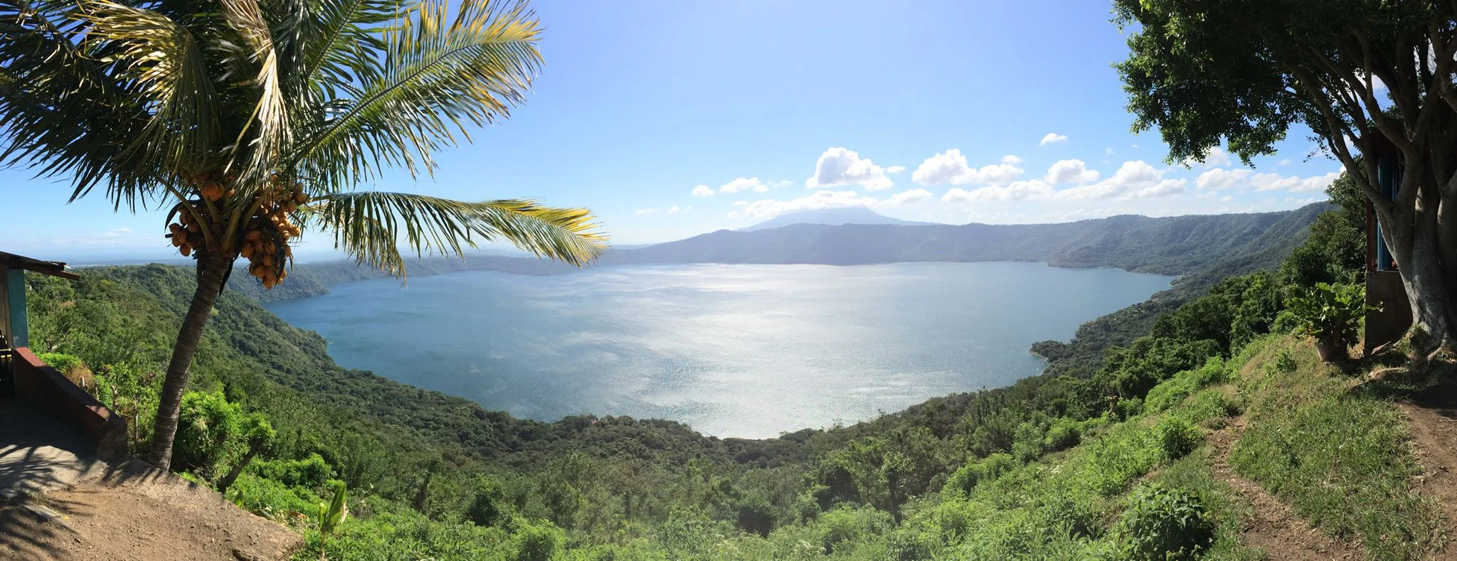
A wide panoramic landscape shot overlooking the large, circular volcanic lake of Laguna de Apoyo, framed by tropical palm and broadleaf trees on the crater slopes.
Panoramic view of the volcanic crater lake at Laguna de Apoyo Nature Reserve.

Laguna de Apoyo Nature Reserve history and protected-area timeline

Laguna de Apoyo was officially declared a nature reserve in 1991, placing the volcanic lake and its drainage basin under formal protection as part of Nicaragua's broader system of protected areas. The reserve is administered by the Ministry of the Environment and Natural Resources, known by the Spanish acronym MARENA, and forms one of 78 protected areas of Nicaragua.

In 2010, a formal management plan was approved for the reserve. This plan established the rules that continue to shape activity within the area, including prohibitions on housing construction inside the reserve and restrictions on the use of motorized vehicles on the lake. The plan provided a framework for handling conflicts over residential development, and several construction projects within the reserve have been halted and landowners engaged in legal processes under its provisions.

Scientific work on the lake's endemic cichlids has unfolded in stages. The arrow cichlid, Amphilophus zaliosus, was described in 1976, predating the reserve's formal establishment. Three additional endemic cichlids were described in 2008 by a multinational research team directed by the Nicaraguan NGO FUNDECI/GAIA, which operates a research station on the lakeshore, and the remaining two were formally described in 2010. These descriptions helped establish Laguna de Apoyo as a key reference site for freshwater evolutionary research in Central America.

Laguna de Apoyo Nature Reserve landscape and geographic character

The defining feature of Laguna de Apoyo Nature Reserve is its volcanic origin. The lake occupies the caldera of an extinct volcano, forming a near-circular body of water roughly 6.6 kilometers in diameter. The caldera walls rise above the surrounding landscape, framing the lake in a continuous arc of forested slopes and creating the quiet, sheltered atmosphere that defines the reserve.

The lake itself is unusually deep, reaching about 175 meters, and covers an area of roughly 19 square kilometers within a drainage basin that extends to about 38 square kilometers. Because the lake is endorheic, with no surface outflow, its shoreline is shaped by water level rather than by rivers exiting the basin. Pumice is common along the lakebed and along the shore, giving the beaches a pale, dark-toned volcanic sand.

Above the waterline, the caldera's slopes carry tropical dry forest vegetation. The terrain rises from lakeshore to crater rim, with hiking trails and viewpoints strung along the higher elevations offering sweeping views of the lake. The mix of steep forested slopes, lakeshore flats, and exposed pumice gives the landscape a layered visual character that is unusual within Nicaragua's protected areas.

Laguna de Apoyo Nature Reserve ecosystems, habitats, and plant life

Laguna de Apoyo Nature Reserve protects a tropical dry forest ecosystem covering the slopes and shoreline of the Apoyo caldera. The forest is dominated by tree species typical of Central American dry forest, including pochote, black rosewood, mahogany, hogplum, and guacuco, with orchids appearing in significant numbers among the understory. More than 500 plant species have been documented within the reserve.

The lake environment is equally important. Its endorheic, deep, and relatively stable waters have supported the evolution of an isolated flock of cichlid fish in the genus Amphilophus, six species of which are endemic to Laguna de Apoyo. The presence of non-native cichlids introduced by humans adds a layer of conservation concern, but the native endemic flock remains a defining ecological feature of the reserve.

Laguna de Apoyo Nature Reserve wildlife and species highlights

Wildlife within Laguna de Apoyo Nature Reserve reflects the broader tropical dry forest fauna of Pacific Nicaragua, combined with rich lacustrine populations.

Mammals recorded in the reserve include variegated squirrels, opossums, anteaters, pacas, jaguarundis, howler monkeys, and white-faced capuchin monkeys. Reptiles include green iguanas and common boas, among others. The reserve has documented more than 230 bird species, a count that includes oropendolas, falcons, and hummingbirds, as well as a substantial contingent of migratory species. Butterflies are also strongly represented, with roughly 220 species recorded, including 25 species described as first records for Nicaragua.

In the lake, six cichlid fish in the genus Amphilophus are endemic to Laguna de Apoyo, including the arrow cichlid. Additional non-native cichlid species have been introduced into the lake by humans. Freshwater mollusks round out the aquatic fauna. The combination of mammals, birds, reptiles, butterflies, and endemic fish gives the reserve a notably broad faunal profile for an area of its size.

Laguna de Apoyo Nature Reserve conservation status and protection priorities

Laguna de Apoyo Nature Reserve carries conservation significance on several fronts. As a protected landscape within Nicaragua's national system, it represents one of 78 protected areas of the country and one of the more distinctive volcanic lake reserves in the Pacific region. Its formal declaration in 1991, followed by a 2010 management plan, established a regulatory framework intended to shield the lake and its forests from uncontrolled development.

The lake's endemic cichlids are a major conservation focus. Six species in the genus Amphilophus occur only in Laguna de Apoyo, and several of them were described only in the last two decades. The presence of introduced cichlid species in the same waters raises concerns about hybridization and ecological pressure on the native flock, making the lake a focal site for freshwater conservation research in Central America.

Management of the reserve also addresses habitat integrity more broadly. Construction of housing within the reserve and the use of motorized vehicles on the lake are prohibited under the management plan, and residential projects inside the reserve have been halted through enforcement actions. Where the lake's water level has shown signs of decline, attention from hydrologists has underscored the importance of managing groundwater flow, land use in the drainage basin, and the impact of tourism infrastructure on the surrounding slopes.

Laguna de Apoyo Nature Reserve cultural meaning and human context

The cultural dimension of Laguna de Apoyo Nature Reserve is rooted both in traditional land use and in more recent archaeological findings. Pumice stones from the lake have long been harvested by local communities for use in the clothing industry, providing a tangible link between the reserve's volcanic geology and everyday economic life in the surrounding region.

More recently, petroglyphs and artifacts of indigenous peoples have been discovered within the reserve, indicating that the Apoyo caldera has a deeper human history than its formal protection history alone would suggest. These findings complicate the older perception of the area as purely natural and add a cultural layer to the reserve's identity. The reserve lies between the departments of Masaya and Granada, regions that are themselves central to Nicaragua's colonial and precolonial heritage, lending the broader landscape a strong cultural backdrop.

Top sights and standout views in Laguna de Apoyo Nature Reserve

Laguna de Apoyo stands out for the unusual combination of a deep volcanic caldera lake, tropical dry forest, and rich freshwater biodiversity within a single protected area. The lake's near-circular shape, endorheic hydrology, and 175-meter depth make it one of the most distinctive volcanic lakes in Central America.

The reserve also stands out for its endemic cichlid flock, with six Amphilophus species found nowhere else, and for its exceptionally high bird count, which includes both resident species and migratory visitors. Discoveries of indigenous petroglyphs, the long tradition of pumice harvesting, and the regulated management of construction and motorized watercraft add further layers of interest, giving the reserve a profile that bridges geology, ecology, conservation, and local culture.

Best time to visit Laguna de Apoyo Nature Reserve

The character of Laguna de Apoyo Nature Reserve shifts with the dry and wet seasons typical of Nicaragua's Pacific region. During the drier months, the tropical dry forest vegetation is at its most open, trails along the caldera slopes are generally easier to walk, and conditions for hiking, paragliding from the crater rim, and lake-based activities tend to be most reliable. Birdwatching remains productive year-round, but the dry season tends to make forest species easier to observe along the edges and clearings.

In the wetter months, the vegetation becomes noticeably greener and denser, and the dry forest canopy fills out with fresh leaf growth. This is often the most visually lush period for the reserve, with orchids and understory plants in active growth, though rains can interrupt outdoor plans and muddy some trails. Migratory bird presence adds to the birdwatching interest during parts of this period. The lake itself, with its calm endorheic waters and volcanic shoreline, remains a focal feature in any season, though water levels have shown variation over time.

Monthly climate preview

Long term temperature and precipitation averages recorded at representative coordinates

Laguna de Apoyo Nature Reserve Climate Normals and Monthly Weather Patterns

Recorded monthly climate data for Laguna de Apoyo Nature Reserve shows sustained warmth alongside distinct shifts in long term precipitation averages across the year. Reviewing the complete twelve month profile provides detailed metrics on temperature ranges and rainfall distribution for this location.
Annual mean28 °C
26 °C30 °C
Jan27°
Feb28°
Mar29°
Apr30°
May29°
Jun28°
Jul27°
Aug28°
Sep27°
Oct26°
Nov26°
Dec27°
Warmest month
April

30.2 °C

Coolest month
November

26.5 °C

Wettest month
September

8 mm/day

Driest month
January

0.1 mm/day

Park location guide

Geography guide, regional context, and park location map for Laguna de Apoyo Nature Reserve

Laguna de Apoyo Nature Reserve park geography, regions, and map view in Nicaragua

Understand where Laguna de Apoyo Nature Reserve sits in Nicaragua through a broader geographic reading of the surrounding landscape, nearby location context, and its mapped position within the national park landscape.

How Laguna de Apoyo Nature Reserve fits into Nicaragua

Nicaragua is a Central American country spanning 130,375 km² with a population of approximately 6.7 million. It borders Honduras, Costa Rica, the Caribbean Sea, and the Pacific Ocean. The official language is Spanish, and the currency is the Córdoba. Known for its agricultural productivity and cultural diversity, Nicaragua has a history dating back to indigenous civilizations before Spanish conquest in the 16th century.

Wider geography shaping Laguna de Apoyo Nature Reserve in Nicaragua

Nicaragua occupies a strategic position in Central America, bordered by Honduras to the north, the Caribbean Sea to the east, Costa Rica to the south, and the Pacific Ocean to the west. The country also shares maritime borders with El Salvador and Colombia. The terrain includes coastal plains, volcanic highlands, and interior valleys. Lake Managua and Lake Nicaragua are major freshwater bodies.

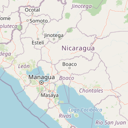
Map view of Laguna de Apoyo Nature Reserve

Use this park location map to pinpoint Laguna de Apoyo Nature Reserve in Nicaragua, understand its exact geographic position, and read its mapped placement within the surrounding landscape more clearly.

Pigeon | © OpenStreetMap contributors

Location context for Laguna de Apoyo Nature Reserve

GranadaMasaya
Recorded earthquake history

Review the Historical Earthquake Catalogue for Laguna de Apoyo Nature Reserve

Examine a curated list of past seismic events recorded in the surrounding area of Laguna de Apoyo Nature Reserve. This dataset serves as a factual resource for understanding regional earthquake history through organized magnitude and distance records provided by MoriAtlas.

Laguna de Apoyo Nature Reserve Earthquake History

Catalogued events

255 events

Strongest magnitude

Magnitude 6.6

Most recent event

Aug 2, 2026

This history includes earthquakes recorded inside the park or within 50 km of its borders

Visual reference for volcanic caldera terrain and tropical dry forest habitats

Laguna de Apoyo Nature Reserve Photos, Landscapes, and Scenery

Visual documentation captures the dramatic topography of Laguna de Apoyo Nature Reserve through detailed photography of its steep volcanic caldera walls and deep crater lake waters. Examining these protected landscapes reveals the distinct vegetation patterns, shoreline features, and geological formations that define the regional ecosystem.

A wide panoramic landscape shot overlooking the large, circular volcanic lake of Laguna de Apoyo, framed by tropical palm and broadleaf trees on the crater slopes.

Park atlas

Compare surrounding regional geography and connected volcanic landscapes

Explore Protected Areas and Parks Near Laguna de Apoyo Nature Reserve

Discover other protected areas near Laguna de Apoyo Nature Reserve to evaluate regional volcanic topography and tropical dry forest habitats. Comparing adjacent reserves helps trace the broader ecological patterns and conservation spread across the surrounding geographic network.
National parkNicaragua
About 12 km away#1 closest

Northwest

Masaya Volcano National Park: Nicaragua National Park Atlas & Landscape Context

Explore the mapped boundaries of this unique volcanic terrain.

Masaya Volcano National Park offers a distinct focus for atlas exploration within Nicaragua's broader geographic framework. This page details the park's identity as a protected landscape, highlighting its volcanic terrain and mapped features. Understand its significance within the national park system and its contribution to the mapped natural heritage of Central America.

IUCN
II
Relief
Mountain
Access
Access unknown
Nature reserveManagua Department
About 17 km away#2 closest

Northwest

Chocoyero-El Brujo Natural Reserve: Geographic Overview and Protected Landscape Mapping

Tropical ravine forest and critical watershed in Managua Department.

This nature reserve protects a vital intersection of tropical forest and steep ravine terrain. Centered on the iconic El Brujo and Chocoyero waterfalls, the area acts as a crucial watershed and nesting ground for green parakeet colonies. The compact, vertical landscape provides a unique look at how small protected areas maintain biodiversity and regional water security near the capital of Nicaragua.

Area
1.8 km²
Established
1993
Visitors
10K annual
Relief
Upland
National parkNicaragua
About 24 km away#3 closest

Southeast

Zapatera Archipelago National Park: Nicaragua National Park Atlas and Protected Landscape Explorer

Explore the mapped boundaries and regional geography.

Zapatera Archipelago National Park serves as a distinct national park within Nicaragua, offering a focused point for exploring protected landscapes and their geographic context. This entry details the park's mapped boundaries and its significance within the atlas of Central American natural areas. Users can understand its role as a protected entity and its contribution to the region's mapped geography, supporting structured discovery of its natural landscape identity.

IUCN
II
Climate
Tropical
Scope
Mixed
Water
Water-dominated
National parkGuanacaste Province
97 km away#4 closest

South

Santa Rosa National Park: Guanacaste Province National Park Protected Area

Mapped natural landscape and regional geography.

Santa Rosa National Park is a vital protected area within Costa Rica's Guanacaste Province. This detail page offers an atlas-focused view of the park, highlighting its geographic setting and mapped boundaries. It serves as a primary resource for understanding the park's protected landscape identity and its contribution to regional conservation geography, supporting structured exploration for users interested in natural areas.

Area
815.31 km²
Established
1966
IUCN
II
Climate
Tropical
National parkGuanacaste Province
101 km away#5 closest

Southeast

Guanacaste National Park: A Protected Landscape within Guanacaste Province's Geography

Explore mapped park boundaries and regional natural landscape context.

Delve into the protected landscape of Guanacaste National Park, a significant national park located within Guanacaste Province. This entry provides a focused view of its geographic features, mapped protected areas, and its role within the regional terrain. Understand the park's specific natural landscape character and its placement in the broader atlas of conservation lands.

Area
340 km²
Established
1991
IUCN
II
Relief
Mixed relief
Nature reserveNicaragua
116 km away#6 closest

Northeast

Cerro Pancasan Natural Reserve: Geographic Overview of a Nicaraguan Protected Forest Hill

Exploring mountain-slope terrain and regional watershed conservation

As a significant hill reserve in western Nicaragua, Cerro Pancasan Natural Reserve protects essential tropical forest cover against agricultural encroachment. This entry provides a detailed look at the reserve's topography, its role in maintaining regional stream flow, and its place within the country-wide SINAP network of protected land.

Scope
Terrestrial
National parkGuanacaste Province
About 141 km away#7 closest

Southeast

Rincón de la Vieja National Park: Costa Rican National Park Atlas Entry

Mapped protected landscape and regional geography.

Gain a structured understanding of Rincón de la Vieja National Park as a key protected area within Guanacaste Province. This detail page offers an atlas-focused perspective, highlighting its mapped boundaries and regional geographic significance. Explore how this national park contributes to the protected landscapes of Costa Rica, providing essential context for geographic discovery.

Area
141.61 km²
Established
1973
IUCN
II
Climate
Tropical
National parkCosta Rica
153 km away#8 closest

Southeast

Miravalles Jorge Manuel Dengo National Park: Costa Rica National Park Geographic Context

Mapped protected landscape and regional park geography.

Miravalles Jorge Manuel Dengo National Park offers a focused lens for understanding protected natural areas within Costa Rica. Explore its specific geographic footprint and the surrounding regional context to appreciate its significance as a mapped protected landscape. This detailed view supports a structured discovery of the park's identity, helping users grasp its place within the national atlas.

Area
43 km²
Established
2019
IUCN
II
Relief
Mountain

Common questions about visiting, size, designation, and location context for Laguna de Apoyo Nature Reserve

Laguna de Apoyo Nature Reserve FAQs for park facts, access, geography, and protected area context

Find quick answers about Laguna de Apoyo Nature Reserve, including protected-area facts, park geography, trail and visitor context, and how the park fits into its surrounding country and regional landscape.
MoriAtlas Explorer

Continue Your Protected Areas Search Across the Global Atlas

Deepen your exploration by continuing the structured search for national parks and protected areas worldwide. Utilize the comprehensive filtering capabilities to compare different conservation landscapes and refine your understanding of global park geography. Discover more about the distribution and characteristics of protected natural areas.

Global natural geography