
Mori Atlas logo
Biosphere reserveÁrea de Allariz

Understanding the intersection of river basins, granitic massifs, and Atlantic;Mediterranean ecosystems

Área de Allariz Biosphere Reserve in Inland Galicia: A Mapped Study of Protected Landscapes

(Reserva de la Biosfera del Área de Allariz)

The Área de Allariz biosphere reserve occupies a critical biogeographic frontier in inland Galicia, Spain, where diverse ecological zones converge within a distinctive tectonic depression. This protected area links the broad, river-drained Limia basin with surrounding granitic massifs, creating a complex mosaic of wetlands, riverside forests, and low-mountain habitats. By examining the park boundaries and regional topography, you can visualize the interplay between historical rural land use and active environmental conservation efforts.

biosphere reserveGaliciainland Galiciabiogeographic transitionAtlantic-Mediterranean borderriver valley
A graphic illustration depicting a tranquil mountain valley featuring a waterfall cascading into a river, framed by coniferous and deciduous trees, with a soft sun rising over distant peaks.

Área de Allariz

Biosphere reserve

Park overview

Structured park overview, official facts, and landscape profile for Área de Allariz

Área de Allariz park facts, protected area profile, and essential visitor context

Review the core facts for Área de Allariz, including designation, size, terrain, visitor scale, habitats, and operating context in one park-focused overview.

About Área de Allariz

The Área de Allariz Biosphere Reserve is a protected territory in the province of Ourense, in the interior of Galicia, northwestern Spain. Declared on 29 June 2005, it brings together the municipalities of Allariz, A Bola, Vilar de Santos, and Rairiz de Veiga under a single framework for conservation and sustainable development. With roughly 21,482 hectares and a population of under 10,000 people, it is a relatively small biosphere reserve by area but is notable for the depth of local engagement with its management model.

Geographically, the reserve sits on a broad, semi-endorheic tectonic depression at an average altitude of around 600 meters, drained by the River Limia and surrounded by a mountainous rim. To the north rises the granitic Allariz massif, through which the River Arnoya cuts a tightly enclosed course. Altitudes vary between roughly 425 and 927 meters, allowing a wide range of habitats to coexist within a compact territory. This setting places the reserve at one of the most ecologically significant biogeographic crossroads on the Iberian Peninsula, marking the boundary between the Eurosiberian (Atlantic) world and the Mediterranean world. As a result, plant communities, animal species, and overall landscape character shift over very short distances.

Natural habitats include broadleaf deciduous forests, riverbank woodlands, meadows, streams, and wetlands, with Mediterranean-influenced communities appearing in drier, sun-exposed areas. The reserve harbors vulnerable and endangered species in Galicia, and is particularly noted for its amphibians, which include several Iberian endemisms. Among the larger fauna, the wolf and the Eurasian otter remain characteristic species, alongside important populations of waterbirds associated with the wetland zones.

Culturally, the territory carries deep historical layers, with numerous Roman and pre-Roman archaeological sites scattered across the landscape. The reserve's zoning system divides the territory into a small core zone protecting the least-altered ecosystems, a buffer zone focused on compatible sustainable activities such as extensive livestock farming, and a large transition zone where most human activity is concentrated. Initiatives in the buffer and transition zones have helped reverse rural depopulation in some areas, in contrast to broader trends in inland Ourense.

Quick facts and research context for Área de Allariz

The Área de Allariz Biosphere Reserve was declared in June 2005 and covers an area of roughly 21,482 hectares spread across four municipalities in the province of Ourense, Galicia. It sits at the meeting point between the Eurosiberian (Atlantic) and Mediterranean biogeographic regions of the Iberian Peninsula, giving it transitional ecological character. More than 94 percent of the reserve is classified as transition zone, with smaller core and buffer areas protecting the most sensitive ecosystems, including riverside forests and remnants of the historic Antela Lagoon landscape.

Protection and recognition

Documented terrestrial protection scope and official UNESCO recognition details

Área de Allariz Protection Status and International Recognition Data

Área de Allariz maintains documented terrestrial protection status alongside verified international recognition through the UNESCO biosphere reserve program. Structured conservation records outline the geographic management framework and official designation history for this protected landscape.

International recognition

Protection details

Protection scope
Terrestrial
Designated year
2005
Core area
1.49 km²
Buffer area
100.94 km²
Park context

Deeper park guide and search-rich context for Área de Allariz

Área de Allariz history, landscape, wildlife, and travel context

Explore Área de Allariz through its history, landscape character, ecosystems, wildlife, conservation priorities, cultural context, and seasonal travel timing in a structured park guide built for atlas discovery and search intent.

Why Área de Allariz stands out

The Área de Allariz is best known as a transitional landscape where Atlantic and Mediterranean ecosystems converge in inland Galicia. Its mosaic of low mountains, river valleys, meadows, and wetlands supports a rich variety of habitats, including riverside forests along the Arnoia and Limia rivers and a surviving remnant of the Antela wetland complex. The reserve is also recognized for its long-running model of sustainable rural development, recognized internationally by the United Nations as a good practice. It combines ecological protection with active traditional land use, including extensive livestock grazing and the recovery of abandoned agricultural and forest land, demonstrating how small inland communities can integrate conservation with rural revitalization.
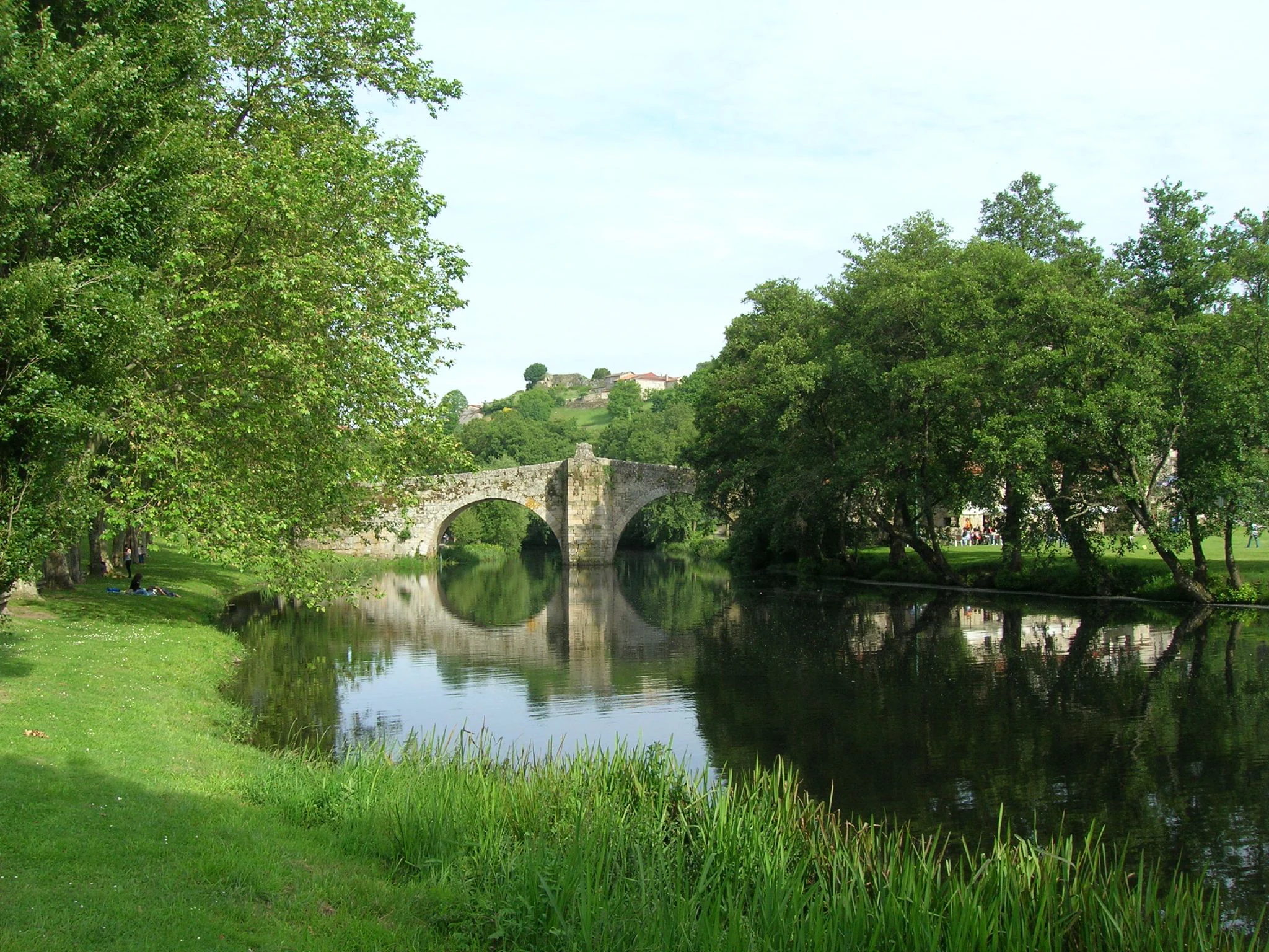
A stone arch bridge reflected in the calm waters of the Arnoia River, surrounded by lush green trees and grassy riverbanks.
The historic Vilanova Bridge spanning the Arnoia River in Allariz.

Área de Allariz history and protected-area timeline

The Área de Allariz was formally declared a biosphere reserve on 29 June 2005, becoming part of UNESCO's worldwide network of biosphere reserves. Its establishment was the outcome of a process that combined scientific research, local participation, and alignment with the Man and the Biosphere programme, as well as existing Spanish and Galician environmental legislation.

Long before its formal designation, the area had been shaped by human activity, with documented Roman and pre-Roman occupation visible across the landscape. Over the twentieth century, rural abandonment and progressive drainage, including the historic draining of the Antela Lagoon, transformed parts of the territory, leaving ecological and social challenges that the biosphere reserve framework sought to address.

Key milestones since 2005 include the careful zoning of the territory into core, buffer, and transition areas, and the implementation of a sustainable development strategy aligned with the Seville Strategy. Recovery programs for abandoned agricultural and forest land, carried out in partnership with local communities managing communal woodlands, received a United Nations mention and were included in the Catalogue of Good Practices. Allariz itself, the reserve's main town, became an early example of endogenous rural development, attracting new residents and reversing population decline at a time when much of inland Ourense was losing people.

Área de Allariz landscape and geographic character

The landscape of the Área de Allariz is shaped by a wide, flat-bottomed tectonic depression that forms the core of the reserve. The River Limia runs through this open basin, giving the territory a calm, broad character at its center, while the surrounding rim of low mountains adds elevation and visual contrast. Average altitudes sit near 600 meters, with the full range stretching from about 425 to 927 meters across the reserve.

To the north, the granitic Allariz massif rises prominently, cut by the tightly meandering River Arnoya, which forms narrow valleys and steep wooded slopes. Southward, the mountains give way again to gentler terrain. This combination of basin, river, and encircling hills produces a visibly layered landscape, where flat agricultural lowlands, riverbank forests, and forested slopes all lie within short distances of one another.

The Antela area, once a major lagoon complex and now largely drained, has left behind wetland fragments and wet meadows that remain ecologically important. Small tributary streams and brooks, such as those of Fontes and the Canelar, add further texture to the terrain, sustaining ribbon-like stretches of riverside vegetation that mark the edges of cultivated land and woodland.

Área de Allariz ecosystems, habitats, and plant life

The Área de Allariz represents one of the clearest examples on the Iberian Peninsula of a biogeographic transition between Atlantic (Eurosiberian) and Mediterranean conditions. This dual character defines the reserve's ecology and gives it unusually high habitat diversity within a relatively small area.

The dominant natural vegetation is temperate deciduous broadleaf forest, traditionally composed of oaks and other broadleaf species, interwoven with a mosaic of meadows, agricultural patches, and small streams. In sunnier, drier, more exposed locations, Mediterranean-affiliated plant communities become increasingly common, creating ecological gradients rather than sharp boundaries. River corridors along the Limia and Arnoya rivers host well-developed gallery forests, recognized as core conservation zones within the reserve.

Wetlands, including remnants of the historic Antela Lagoon landscape and various small marshy areas, provide some of the most valuable habitats for fauna and contribute to the reserve's importance for migratory and resident waterbirds. Together, forests, meadows, rivers, wetlands, and Mediterranean-edge habitats form a finely interlaced ecological mosaic that supports both common and threatened species.

Área de Allariz wildlife and species highlights

Wildlife in the Área de Allariz reflects the reserve's position at the meeting point of two major biogeographic regions. The combination of forests, meadows, rivers, and wetlands supports a high diversity of vertebrate fauna, including species that are vulnerable or endangered elsewhere in Galicia.

Among larger mammals, the wolf continues to hold a presence in the more remote and wooded parts of the territory, while the Eurasian otter inhabits the cleaner stretches of the Limia and Arnoya river systems. The reserve's varied habitats support a particularly notable amphibian fauna, with multiple Iberian endemisms among its frog, toad, and salamander populations, making the area significant for the conservation of these often-threatened groups.

Birds are an important component of the reserve's wildlife value, especially in and around the wetland remnants of the Antela area, which attract diverse aquatic and marshland species. The overall richness of forms, both common and protected, contributes to the reserve's recognition as a key area for conservation in inland Galicia.

Área de Allariz conservation status and protection priorities

The Área de Allariz holds significant conservation value both for its role as a biogeographic transition zone and for its function as a working landscape where biodiversity and human activity coexist. The reserve is organized into core, buffer, and transition zones, with the smallest, most strictly protected areas reserved for the least-altered ecosystems.

Core zones protect fragments of riverside forest along the Arnoia, small wetland remnants near the former Antela Lagoon, and culturally important natural features such as ancient oak trees and pre-Roman settlement sites with associated native woodlands. These areas safeguard the most resilient examples of the reserve's natural heritage.

Buffer zones occupy a modest share of the territory but play a critical role in absorbing pressure from more intensively used areas. Sustainable activities are promoted here, including extensive livestock farming with native breeds and the recovery of communal woodlands and farmland that had fallen into abandonment. These community-led efforts have been recognized internationally, including by the United Nations, as a good practice in balancing rural development with conservation. In the broader transition zone, which covers the majority of the reserve, planning tools and the Seville Strategy framework guide land use toward sustainability, helping maintain ecological functions while supporting the livelihoods of local communities.

Área de Allariz cultural meaning and human context

The Área de Allariz sits in a region with deep historical layers visible in its landscape. Numerous Roman and pre-Roman archaeological sites are scattered across the territory, including notable hillfort (castro) sites such as Castrelo and San Miguel, which combine cultural significance with commanding views over the surrounding wetlands and river valleys.

Traditional rural architecture, including wooden granaries, remains a recognizable feature of the local villages, reflecting centuries of agricultural and pastoral life. The reserve's population, small but engaged, has actively shaped its environmental trajectory, particularly in Allariz itself, where an endogenous development model launched around the early 2000s helped reverse rural depopulation and fostered a strong local sense of place tied to landscape, heritage, and sustainability.

Community management of communal woodlands (montes vecinais) by local parishes has been central to the recovery of abandoned land and the maintenance of cultural landscapes, embedding conservation within long-standing Galician rural traditions.

Top sights and standout views in Área de Allariz

The Área de Allariz stands out for its role as a biogeographic frontier, where Atlantic and Mediterranean worlds meet within a single, compact territory. Its mix of flat-floored basins, granitic massifs, river valleys, and wetland remnants creates an unusually varied mosaic of habitats in inland Galicia.

Equally distinctive is the reserve's community-driven model of conservation, in which strict core protection, carefully managed buffer areas, and a large, lived-in transition zone work together. International recognition, including a United Nations good practice mention, and visible rural revitalization, especially in Allariz, highlight how the reserve integrates ecological protection with active cultural and social life.

Best time to visit Área de Allariz

The Área de Allariz has a temperate inland Galician climate, with warm, relatively dry summers and cool, wetter winters. Spring is often especially rewarding, as meadows and deciduous forests come into leaf, rivers run full, and wildlife, particularly amphibians and breeding birds, is most active.

Autumn brings a second visual peak, with broadleaf forests turning color and quieter walking conditions. Summer offers the warmest, most comfortable conditions for exploring the lower basin and villages, though mid-day heat can be notable at lower elevations. Winters are generally mild but can be damp, with mist in the basin and occasional cold spells at higher elevations on the surrounding mountains.
Monthly climate preview

Long-term monthly temperature averages and precipitation patterns for Área de Allariz

Área de Allariz Climate Normals, Temperature Ranges, and Precipitation Rhythms

Representative coordinates record measured monthly temperature swings from mean lows of 4.23 degrees Celsius to highs of 35.67 degrees Celsius alongside shifting precipitation rates. Opening the complete twelve-month climatology profile provides deeper monthly data for analyzing long-term environmental patterns.
Annual mean12 °C
4 °C21 °C
Jan
Feb
Mar
Apr
May13°
Jun17°
Jul21°
Aug21°
Sep17°
Oct12°
Nov
Dec
Warmest month
August

20.8 °C

Coolest month
January

4.2 °C

Wettest month
December

4.3 mm/day

Driest month
July

0.6 mm/day

Park location guide

Geography guide, regional context, and park location map for Área de Allariz

Área de Allariz park geography, regions, and map view in Spain

Understand where Área de Allariz sits in Spain through a broader geographic reading of the surrounding landscape, nearby location context, and its mapped position within the national park landscape.

How Área de Allariz fits into Spain

Spain, officially the Kingdom of Spain, is a unitary parliamentary constitutional monarchy located in Southern and Western Europe. The country occupies most of the Iberian Peninsula and includes territories in the Mediterranean and Atlantic. With a population of approximately 49.6 million and an area of 506,030 km², Spain is a major European economy and cultural force. Its capital is Madrid, and the country is known for its diverse landscapes ranging from mountainous regions to coastal areas.

Wider geography shaping Área de Allariz in Spain

Spain occupies the Iberian Peninsula in Southern and Western Europe. Peninsular Spain is bordered to the north by France, Andorra, and the Bay of Biscay; to the east and south by the Mediterranean Sea and Gibraltar; and to the west by Portugal and the Atlantic Ocean. The territory includes the Canary Islands in the Atlantic Ocean, the Balearic Islands in the Mediterranean Sea, and the autonomous cities of Ceuta and Melilla in mainland Africa. Spain features diverse terrain including the Pyrenees in the northeast, the Sierra Nevada in the south, and the Meseta Central plateau.

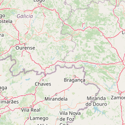
Map view of Área de Allariz

Use this park location map to pinpoint Área de Allariz in Spain, understand its exact geographic position, and read its mapped placement within the surrounding landscape more clearly.

Pigeon | © OpenStreetMap contributors

Location context for Área de Allariz

Galicia
Natural feature types

Explore the Physical Geography and Named Features of Área de Allariz

Examine the tectonic and hydrological components that define the Área de Allariz landscape. This structured collection helps you navigate the diverse terrain types and natural landmarks within this Galician biosphere reserve for a deeper understanding of its regional environmental context.
Recorded earthquake history

Explore Historical Earthquake Records Associated with Área de Allariz

Investigate the historical seismic catalogue linked to the Área de Allariz landscape. This MoriAtlas dataset allows for the review of recorded event magnitudes and epicentre locations, providing clear geographic context for regional seismic activity in inland Galicia.

Área de Allariz Earthquake History

Catalogued events

52 events

Strongest magnitude

Magnitude 4.1

Most recent event

Jul 25, 2004

This history includes earthquakes recorded inside the park or within 50 km of its borders

Visual reference collection highlighting river valleys, low mountains, and transitional ecosystems in inland Galicia

Área de Allariz Photos: Exploring Landscapes, Scenery, and Protected Habitats

Visual documentation reveals the layered terrain and diverse natural habitats spanning the protected biosphere reserve. Detailed photography of river corridors, wetlands, and mountain massifs helps observers interpret the unique geography defining the region.

A stone arch bridge reflected in the calm waters of the Arnoia River, surrounded by lush green trees and grassy riverbanks.

A weathered wooden granary, or horreo, raised on stone pillars in a grassy area with trees and a building in the background.

Park atlas

Compare adjacent river valleys, mountain massifs, and regional reserves

Parks Near Área de Allariz and Surrounding Protected Natural Areas

Visitors exploring Área de Allariz can browse adjacent protected areas to examine similar river basins and low mountain topography across inland Galicia. Comparing these connected regional landscapes reveals broader patterns in transition zones, wetland remnants, and sustainable rural conservation.
Watercolor illustration of a river winding through a valley with mountains, forests, and pink flowering trees.
National parkPortugal
11 km away#1 closest

Southwest

Peneda-Gerês National Park: A Distinct Protected Landscape in Northern Portugal

Granite peaks, glacial valleys, and cultural heritage mapped.

Peneda-Gerês National Park represents a cornerstone of protected landscapes in Portugal, celebrated for its rugged granite mountains and deep glacial valleys sculpted over millennia. This national park showcases a rare ecological transition zone with unique endemic species and features dramatic waterfalls and pristine river systems. The park's rich cultural tapestry, interwoven with its natural environment, offers a compelling subject for atlas-based geographic discovery and landscape exploration.

Area
695.93 km²
Established
1971
IUCN
II
Visitors
92.8K annual
Watercolor depiction of green hills, a small pond, and distant mountains under a soft sky.
Protected landscapeBragança District
50 km away#2 closest

East

Montesinho Natural Park: Protected Landscape in Bragança District, Portugal

Explore mapped boundaries and regional landscape context.

Montesinho Natural Park is designated as a protected landscape in northeastern Portugal, located within the administrative region of Bragança District. This page serves as an entry point to understanding the park's protected area characteristics, its mapped geographic footprint, and its role in the broader natural landscape of the Trás-os-Montes region. Discover the atlas value of this significant protected territory and its relation to surrounding geography.

Area
742.25 km²
Established
1979
IUCN
V
Relief
Mountain
Watercolor illustration of a gentle river winding through green hills and forests with soft, hazy mountain silhouettes in the background.
Biosphere reserveGalicia
61 km away#3 closest

North

Reserva de la biosfera de las Tierras del Miño: Mapped Landscapes and Geographic Overview

Extensive riverine forests and wetland networks in northwestern Spain

Explore the expansive territory of Reserva de la biosfera de las Tierras del Miño, spanning a large portion of the Galician interior. This protected area features a mosaic of wetlands, riparian corridors, and mountainous terrain, offering a deep look into the ecological and cultural geography of the upper Miño river basin.

Area
3,636.69 km²
Established
2002
Relief
Lowland
Scope
Terrestrial
Watercolor landscape illustration featuring mountains, forests, fields, and trees
Protected areaPortugal
69 km away#4 closest

South

Alvão Natural Park Protected Area: Atlas Exploration of Northern Portugal's Mountain Geography

Discover dramatic landscapes and mapped terrain.

Alvão Natural Park is a protected area in northern Portugal distinguished by its stark geological contrasts: upper granite plateaus and steep schist lowlands. This unique geography supports diverse ecosystems and features the impressive Fisgas de Ermelo waterfall. Explore the park's mapped boundaries and its role as a significant protected landscape within the region, offering rich context for any geographic exploration.

Area
72.03 km²
Established
1983
IUCN
V
Visitors
29.6K annual
Watercolor illustration of rolling green hills and distant purple mountains under a light sky
National parkGalicia
78 km away#5 closest

West

Atlantic Islands of Galicia National Park: Protected Archipelagos & Galician Coastline Geography

Explore mapped island ecosystems and protected marine areas.

Uncover the protected landscape of the Atlantic Islands of Galicia National Park, Spain's only national park in Pontevedra province. This atlas entry details the four distinct archipelagos, Cíes, Ons, Sálvora, and Cortegada, across the Rías Baixas. Discover the unique sea-land protected area, its rare bay laurel forests, significant seabird colonies, and the broader regional geography of Galicia.

Area
84.8 km²
Established
2002
IUCN
II
Visitors
472.3K annual
Watercolor painting of a wide, rolling mountain landscape with green and muted red hills under a soft, light background.
Biosphere reserveLugo
82 km away#6 closest

Northeast

Reserva de la Biosfera de Los Ancares Lucenses y Montes de Cervantes, Navia y Becerreá Protected Area Map

Mountainous terrain and river valley geography in Lugo, Spain

This protected area covers the dramatic Sierra de Ancares, featuring steep mountain slopes and deep river valleys that define the geography of Galicia. The reserve spans a significant vertical relief, providing essential habitats for brown bears and capercaillie while preserving traditional rural mountain land use systems and ancient forest ecosystems.

Area
536.64 km²
Established
2006
Relief
Mountain
Climate
Temperate
A soft, horizontal watercolor painting showing a calm body of water with gentle grassy banks, trees on the left, and distant rolling hills.
Biosphere reserveGalicia
82 km away#7 closest

North

Reserva de la biosfera de las Mariñas Coruñesas y Tierras del Mandeo: Regional Geography and Maps

A diverse protected area across Galicia, Spain

This biosphere reserve serves as a vital ecological refuge along the Cantabrian-Atlantic coast. The protected area features a unique mosaic of marine and terrestrial habitats, ranging from rocky coastal cliffs and sandy estuaries to dense Atlantic forest fragments and the mountainous interior of the Sierra de la Cova da Serpe.

Area
1,139.7 km²
Established
2013
Relief
Mixed relief
Climate
Temperate
A soft watercolor painting depicting rolling green hills, distant mountains, a river, and stylized pink trees against a plain background.
Biosphere reserveProvincia de León
87 km away#8 closest

Northeast

Reserva de la biosfera de los Ancares Leoneses: Protected Mountain Terrain and Atlas

Mapping the Sierra de Ancares river valleys in Provincia de León

Examine the geographic layout and protected boundaries of the Reserva de la biosfera de los Ancares Leoneses. This biosphere reserve serves as a critical mountain corridor, featuring complex river basins and diverse forest cover that highlight the region's environmental and cultural history across the Spanish highlands.

Area
567.86 km²
Established
2006
Relief
Mountain
Scope
Terrestrial

Common questions about visiting, size, designation, and location context for Área de Allariz

Área de Allariz FAQs for park facts, access, geography, and protected area context

Find quick answers about Área de Allariz, including protected-area facts, park geography, trail and visitor context, and how the park fits into its surrounding country and regional landscape.
MoriAtlas Explorer

Continue Your Protected Areas Search Across the Global Atlas

Deepen your exploration by continuing the structured search for national parks and protected areas worldwide. Utilize the comprehensive filtering capabilities to compare different conservation landscapes and refine your understanding of global park geography. Discover more about the distribution and characteristics of protected natural areas.

Global natural geography