Mori Atlas logo
Protected areaArltunga Historical Reserve

Trace the historic stone ruins and natural terrain of this Eastern Arrernte Country landmark

Arltunga Historical Reserve: Protecting Gold Rush Heritage and Arid Landscapes in Central Australia

Arltunga Historical Reserve preserves the remnants of the first major European gold rush settlement within the harsh arid environment of Central Australia. Located east of Alice Springs, the area serves as a significant protected landscape that integrates nineteenth century mining infrastructure, such as the Government Battery and local stone-built dwellings, with deep cultural associations linked to the traditional Eastern Arrernte site of Arnerre-ntyenge.

historical reservegold rush heritageCentral AustraliaNorthern TerritoryEastern Arrernte Countryabandoned mining town

Arltunga Historical Reserve

Protected area

Park overview

Structured park overview, official facts, and landscape profile for Arltunga Historical Reserve

Arltunga Historical Reserve park facts, protected area profile, and essential visitor context

Review the core facts for Arltunga Historical Reserve, including designation, size, terrain, visitor scale, habitats, and operating context in one park-focused overview.

About Arltunga Historical Reserve

Arltunga Historical Reserve is one of the Northern Territory's most distinctive cultural heritage landscapes, protecting the remains of a once-thriving gold mining township that briefly flourished in the remote arid heart of Australia. The reserve lies about 110 kilometres east of Alice Springs within the locality of Hart, set in the rugged, dry country of Central Australia. At roughly 5,000 hectares, it preserves not only the stone remnants of the mining town itself but also the surrounding rises, creek lines, and rockhole sources that originally drew prospectors to the area.

The site takes its European name from Arltunga, a transliteration connected to the rockhole the miners knew as Paddy's Rockhole, though different interpretations link the name either to a place where animals became stuck and died or to a Luritja dialect term for easterners. This bilingual identity is central to the reserve's significance, as the Eastern Arrernte people have occupied this Country, known to them as Inerentye, for thousands of years and remain the traditional owners of the land. The rockhole itself, Arnerre-ntyenge, was a vital water source long before any European presence and continues to anchor the site's meaning for Arrernte communities today.

Arltunga is closely associated with the wider story of inland Australian mineral discovery and frontier settlement. South Australian explorer David Lindsay observed gold in the creek sands at Paddy's Rockhole in 1887, just after his 1886 discoveries at nearby Ruby Gap. The find triggered a mining rush and led to the construction of substantial mining infrastructure, the rise of a remote township, and the establishment of Alice Springs as a service town. Later discoveries at The Granites and Tennant Creek in the late 1920s and early 1930s gradually drained Arltunga of population, leaving behind a stone-built township that has remained largely undisturbed.

The reserve was formally established in 1975 by the Parks and Wildlife Commission of the Northern Territory to protect the surviving structures and the broader cultural landscape. Despite the harsh Central Australian climate, the use of local stone in construction has allowed much of the town, including the police station, gaol, hotel, battery works, and cemetery remains, to survive in remarkable condition. Heritage listings followed in stages: the Government Battery and Cyanide Works were added in 1995, and the broader reserve was finally recognised in 2014 following the resolution of a native title claim.

Quick facts and research context for Arltunga Historical Reserve

Arltunga Historical Reserve sits in the locality of Hart in the Northern Territory of Australia, approximately 110 kilometres east of Alice Springs at an elevation of around 661 metres. Established as a reserve in 1975, it covers roughly 5,000 hectares and is managed by the Parks and Wildlife Commission of the Northern Territory.

The reserve is recorded on the former Register of the National Estate. The Government Battery and Cyanide Works were listed in 1995, and the broader reserve was successfully heritage-nominated in 2014 after a native title claim that had stalled earlier listings was resolved.

Protection and recognition

Documented terrestrial protection scope and official designation records

Arltunga Historical Reserve Protection Status and Recognition Data

Arltunga Historical Reserve maintains a documented terrestrial protection scope without imported international recognition sources. Structured designation records outline the official conservation status and management framework governing the reserve.

Protection details

Protection scope
Terrestrial
Park context

Deeper park guide and search-rich context for Arltunga Historical Reserve

Arltunga Historical Reserve history, landscape, wildlife, and travel context

Explore Arltunga Historical Reserve through its history, landscape character, ecosystems, wildlife, conservation priorities, cultural context, and seasonal travel timing in a structured park guide built for atlas discovery and search intent.

Why Arltunga Historical Reserve stands out

Arltunga Historical Reserve is best known as the first major European settlement in Central Australia, a remote outback gold rush township whose stone-built ruins still stand more than a century after the mining boom ended. The reserve preserves a striking cluster of late nineteenth and early twentieth century mining infrastructure, including the Government Battery and Cyanide Works, the old police station and gaol, the 1905 Winnecke Hotel, and two historic cemeteries. Beyond its mining history, the reserve is recognised for its deep cultural significance as part of the Eastern Arrernte estate of Inerentye, anchored by the rockhole Arnerre-ntyenge. The combination of weathered stone buildings, sparse outback setting, and layered cross-cultural history gives Arltunga its distinctive character among Australian heritage landscapes.
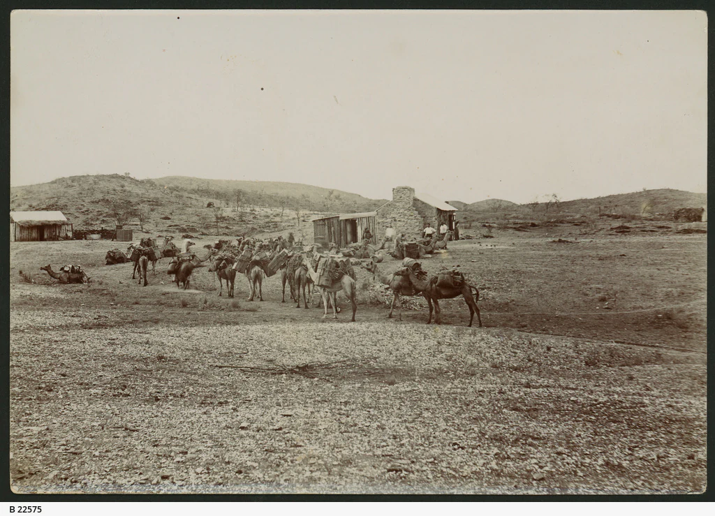
A black and white archival photograph showing a group of camels with packs in a dry, rocky landscape near small stone buildings.
A historical photograph of a camel team at the Arltunga goldfields, circa 1898.

Arltunga Historical Reserve history and protected-area timeline

The history of Arltunga Historical Reserve spans thousands of years of Eastern Arrernte presence and a more concentrated but dramatic period of European mining and settlement in the late nineteenth and early twentieth centuries. The site, located within the Eastern Arrernte estate of Inerentye and centred on the rockhole Arnerre-ntyenge, has been part of Arrernte life for millennia. When European prospectors arrived, the Eastern Arrernte were central to the survival and success of the new settlement, working as guides, trackers, labourers, miners, messengers, and domestic help, and sharing crucial knowledge of local water sources and bush foods. Many also worked on pastoral stations in the region, including Atnarpa, Loves Creek, Ambalindum, and The Gardens.

The European history of Arltunga began in 1887 when South Australian explorer David Lindsay observed gold in the creek sands below Paddy's Rockhole during an expedition from Port Darwin to the South Australian coast. Lindsay had previously found what he thought were rubies at Ruby Gap in 1886, later identified as high-quality garnets. The 1887 discovery sparked the first major gold rush in Central Australia and led to the founding of a substantial mining township. To support Arltunga, Lindsay was commissioned to survey the town of Stuart, the future Alice Springs, so that it could supply the inland settlement with goods.

Mining infrastructure was built rapidly and at considerable cost. In 1898 the South Australian Government constructed the Government Battery and Cyanide Works under the supervision of James Gilbert Woolcock, who faced major logistical difficulties. The following year, contractors William Hurle Liddle and Gerhardt Johannsen built the police station and its associated outbuildings. Despite these investments, development was slowed by a severe drought in the 1890s that dried up wells and left horses too weak to cart ore, and again in 1901 when the battery burst and halted ore processing for several months.

Conditions improved in 1903 with a fresh rush at the nearby Winnecke Goldfield, and by 1905 a new well, store, and hotel had been established. At the turn of the century the population on the goldfield stood between 350 and 400 people. The later discovery of gold at The Granites and Tennant Creek in the late 1920s and early 1930s drew miners away, and persistent difficulties with water supply accelerated the decline. By 1933 the population had fallen to just 25.

A later chapter began in 1944 when the Little Flower Mission of the Missionaries of the Sacred Heart moved from Alice Springs to the largely abandoned township, renaming it Arltunga Mission. Much of the relocation work was undertaken by lay missionary Francis McGarry, who had also chosen the new site, though he resigned or was asked to leave shortly after the move was completed. In 1953 the mission was relocated again to Phillipson's Block and renamed Santa Teresa Mission, now the community of Ltyentye Apurte. Following this second move, Arltunga was gradually abandoned once more, leaving its stone buildings to weather the Central Australian climate.

Arltunga Historical Reserve was formally established in 1975 and encompasses 5,000 hectares of the surrounding landscape. Heritage recognition followed in stages: the Government Battery and Cyanide Works were listed in 1995, and the reserve itself was nominated for listing in 2008, with the broader nomination finally succeeding in 2014 after a native title claim was resolved. The reserve is also recorded on the former Register of the National Estate.

Arltunga Historical Reserve landscape and geographic character

The landscape of Arltunga Historical Reserve is classic Central Australian arid country, set among low ranges, scattered rises, and shallow creek lines typical of the east of Alice Springs region. The reserve sits at around 661 metres elevation and is characterised by sparse vegetation, rocky outcrops, and stark seasonal contrasts, with hot summers reaching well above 40 degrees Celsius and cool winters that can drop several degrees below freezing.

The defining natural feature of the reserve is the rockhole known as Paddy's Rockhole or Arnerre-ntyenge, which gave the site its original significance both as a watering place for Aboriginal people and as the location of the first gold discovery in the area. The surrounding terrain is weathered and exposed, and it is this environment that has helped preserve the stone buildings, since early builders relied on local stone in a landscape where timber and water were scarce.

The two small cemeteries within the reserve, Crossroads Cemetery and White Range Cemetery, also sit within this arid setting, where their isolation adds to the atmosphere of abandonment and endurance that defines the reserve.
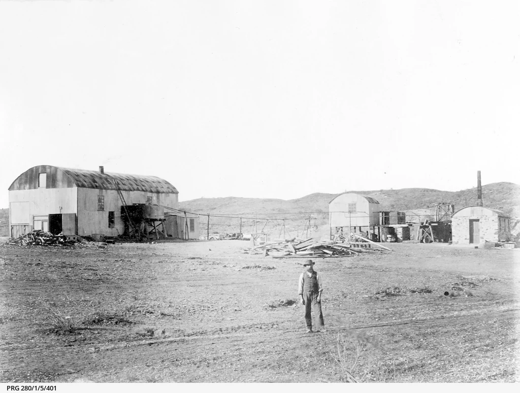
A black and white historical photograph showing several corrugated iron buildings in an arid, rocky landscape. A lone person stands in the foreground, with distant hills in the background.
A historical photograph of the Government Battery at Arltunga, Northern Territory, circa 1900.

Arltunga Historical Reserve ecosystems, habitats, and plant life

The natural environment of Arltunga Historical Reserve reflects the broader arid ecology of Central Australia's east MacDonnell region. Vegetation is sparse and adapted to extreme heat and low rainfall, with typical patterns of dry-country grasses, drought-tolerant shrubs, and isolated stands of hardy trees concentrated around the rockholes and creeks.

Wildlife in the reserve is consistent with that of the surrounding desert country, where birdlife, reptiles, and small mammals are present but sparsely distributed, often moving between the limited water sources that become focal points in the dry seasons. The harsh and exposed setting shapes almost every aspect of the reserve's ecological character.
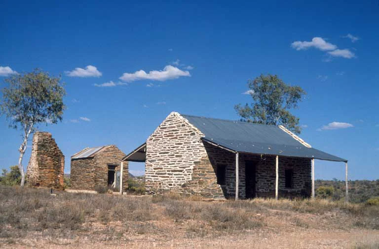
A view of two historic stone buildings under a bright blue sky at Arltunga Historical Reserve, featuring dry desert brush and sparse trees.
Historic stone gaol ruins in the arid landscape of Arltunga Historical Reserve.

Arltunga Historical Reserve conservation status and protection priorities

The primary conservation value of Arltunga Historical Reserve lies in the survival of an exceptionally intact remote Australian mining township. Established formally as a reserve in 1975 and now covering 5,000 hectares, the site preserves a wide range of late nineteenth and early twentieth century mining, administrative, and domestic structures whose stonework has withstood one of the harshest climates in Australia. The reserve's conservation value is enhanced by its essentially unmodified arid landscape, which retains much of the visual isolation that defined Arltunga during its working life.

Heritage recognition reflects this importance. The Government Battery and Cyanide Works were listed in 1995, and a broader nomination for the rest of the reserve, initially held back by a native title claim, was finally successful in 2014. The reserve is also recorded on the former Register of the National Estate, confirming its standing among Australia's most significant inland cultural heritage sites. Beyond its built fabric, the reserve's conservation value extends to its role in recognising and protecting the continuing cultural connection of the Eastern Arrernte people to Arnerre-ntyenge and the broader Country of Inerentye.

Arltunga Historical Reserve cultural meaning and human context

Arltunga Historical Reserve has a deep and layered cultural context that extends well beyond its European mining history. The site sits within Inerentye Country, the traditional lands of the Eastern Arrernte people, who have occupied this part of Central Australia for thousands of years. The reserve's Eastern Arrernte name, Arnerre-ntyenge, refers to a rockhole that was a vital water source and continues to carry deep significance for Arrernte communities. Two interpretations of the name itself, one referring to animals becoming stuck in the water and another suggested as a corruption of a Luritja word meaning easterners, reflect the cultural complexity of the area's place-naming traditions.

The era of European mining brought significant cultural change. Eastern Arrernte people were central to the survival and success of the new settlers, working across a wide range of roles as guides, trackers, labourers, miners, messengers, and domestic help, and sharing detailed knowledge of the Country, particularly of water sources and bush foods. Many Arrernte people also worked on nearby pastoral stations such as Atnarpa, Loves Creek, Ambalindum, and The Gardens, a pattern that linked the reserve to broader regional labour and social history.

Several notable figures emerged from this period of cross-cultural contact. Chinese market gardener Ah Hong regularly travelled to Arltunga with fresh vegetables for the miners. Gwoya Tjungurrayi and his family escaped to the Arltunga region in the aftermath of the Coniston massacre, and he later worked as a gold miner there. Topsy Smith and her husband William "Bill" Smith spent many years on the Arltunga Goldfields, and their son Walter Smith grew up there. Hetty Perkins, who later worked at The Bungalow, was born at Arltunga, and bushman Ben Nicker was born just north of the goldfields. A later cultural layer was added when the Little Flower Mission of the Missionaries of the Sacred Heart moved to the abandoned township in 1944, operating there for nearly a decade before relocating in 1953 to become Santa Teresa Mission, now the community of Ltyentye Apurte.
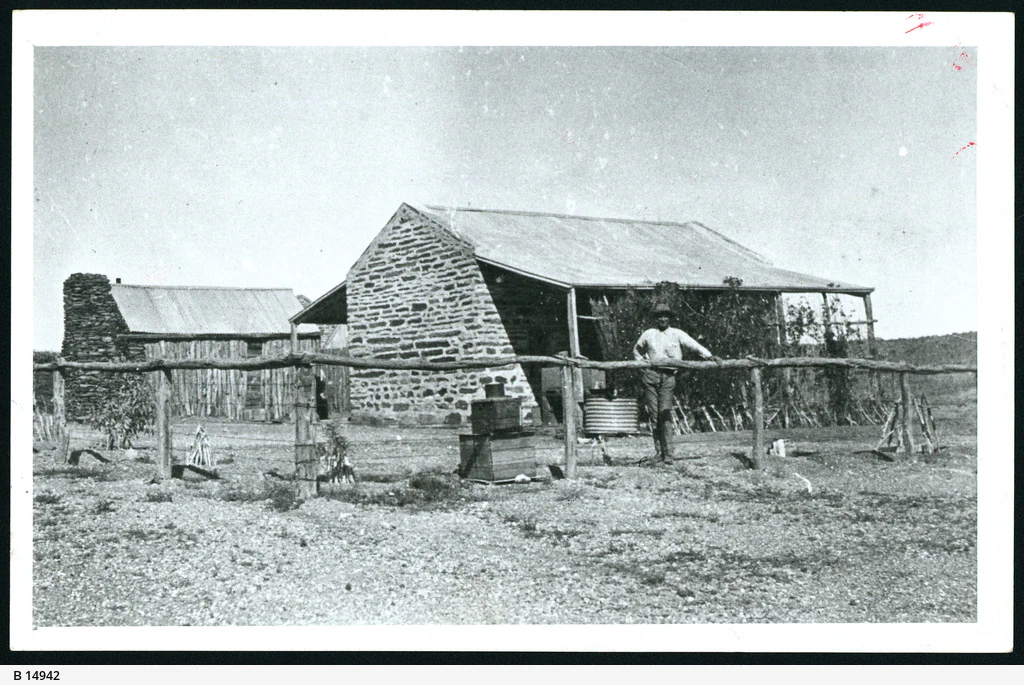
A black and white historical photograph showing a man standing in front of a stone police station building in Arltunga, with a simple wooden fence in the foreground.
Sergeant GH Noblett standing in front of the Arltunga police station in 1920.

Top sights and standout views in Arltunga Historical Reserve

Among the highlights of Arltunga Historical Reserve are the surviving stone-built Government Battery and Cyanide Works, the historic police station and gaol, and the remains of the 1905 Winnecke Hotel, all set within an arid landscape that has changed little since the gold rush era. The two cemeteries, Crossroads Cemetery and White Range Cemetery, offer insight into the lives of miners and Aboriginal people who lived and worked on the goldfield. The reserve's location within Inerentye Country and its continued association with the rockhole Arnerre-ntyenge give the site a cultural depth that extends well beyond its European mining history, making it one of the most evocative heritage reserves in inland Australia.
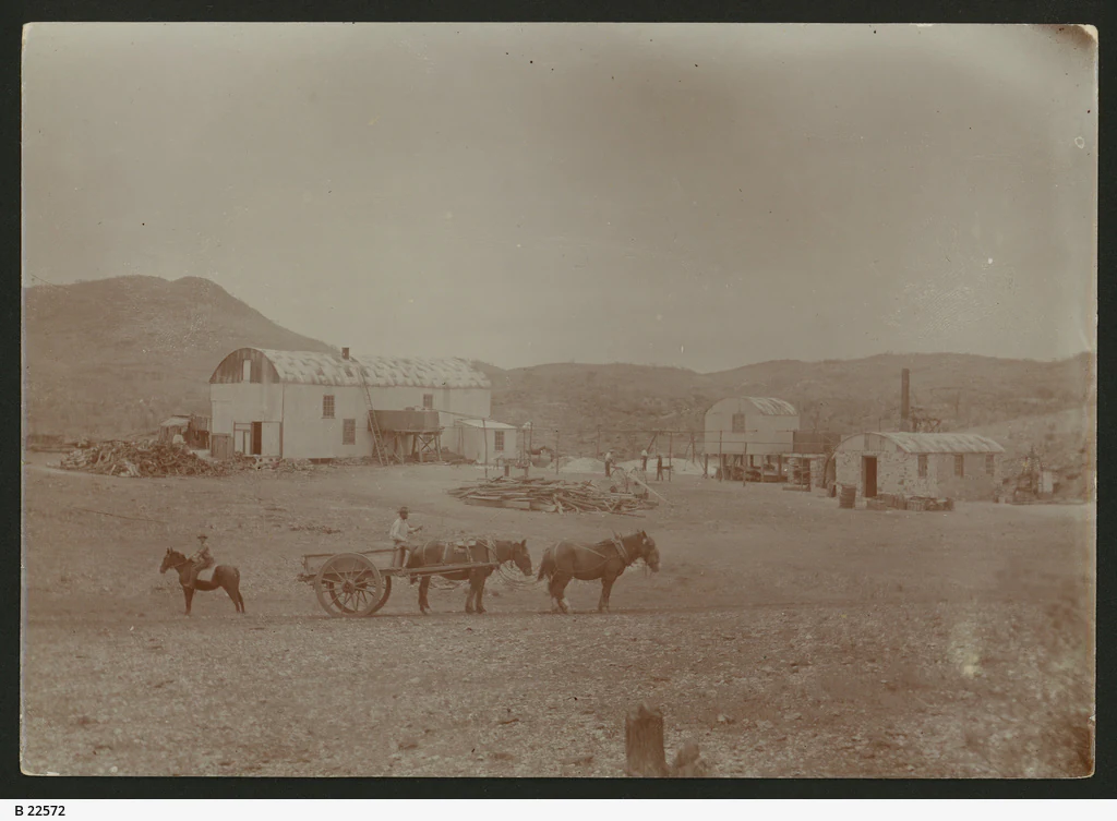
Black and white historical photograph showing several small wooden and corrugated iron structures in a dry, sparse landscape with horses and a cart in the foreground.
Historical photograph of the Cyanide Works at Arltunga, circa 1890.

Best time to visit Arltunga Historical Reserve

The coolest and most comfortable months to experience Arltunga Historical Reserve are typically from April through August, when daytime temperatures are mild and nights can be cold but rarely extreme. Winters bring clear skies, low rainfall, and crisp visibility across the ranges, making this an especially good period for exploring the townsite, walking between the stone buildings, and visiting the cemeteries.

Summer months from November to February are noticeably hotter, with daytime highs regularly above 35 degrees Celsius, and visits during this period typically require careful planning around heat and water. Whatever the season, the dry climate means that weather interruptions are uncommon, although winter mornings can occasionally bring frost.
Monthly climate preview

Long-term representative monthly averages for temperature and precipitation rhythm

Arltunga Historical Reserve Climate Normals and Annual Temperature Patterns

Arltunga Historical Reserve exhibits a measured annual temperature and precipitation rhythm derived from long-term representative coordinate sampling between 1991 and 2020. Examining the complete monthly climate profile provides deeper context for temperature extremes and seasonal moisture variations across the landscape.
Annual mean22 °C
13 °C30 °C
Jan30°
Feb29°
Mar26°
Apr22°
May17°
Jun13°
Jul13°
Aug15°
Sep21°
Oct24°
Nov28°
Dec29°
Warmest month
January

30.5 °C

Coolest month
July

12.8 °C

Wettest month
January

1.8 mm/day

Driest month
August

0.1 mm/day

Park location guide

Geography guide, regional context, and park location map for Arltunga Historical Reserve

Arltunga Historical Reserve park geography, regions, and map view in Australia

Understand where Arltunga Historical Reserve sits in Australia through a broader geographic reading of the surrounding landscape, nearby location context, and its mapped position within the national park landscape.

How Arltunga Historical Reserve fits into Australia

Australia is a constitutional monarchy and federal parliamentary democracy comprising six states and ten territories. With a population of nearly 28 million, it is one of the world's most urbanised countries, with most people concentrated on the eastern seaboard. The country has a high Human Development Index and is known for its cultural diversity, ancient Aboriginal heritage, and unique wildlife.

Wider geography shaping Arltunga Historical Reserve in Australia

Australia occupies the entire Australian continent, the island of Tasmania, and numerous smaller islands. It is the world's flattest and driest inhabited continent, featuring vast deserts in the interior (the Outback), tropical rainforests along the eastern coast, and a coastline bordering the Indian and Pacific Oceans.

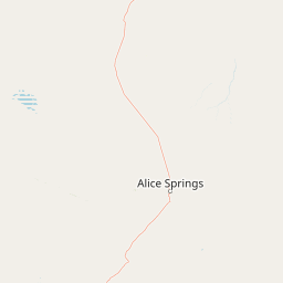
Map view of Arltunga Historical Reserve

Use this park location map to pinpoint Arltunga Historical Reserve in Australia, understand its exact geographic position, and read its mapped placement within the surrounding landscape more clearly.

Pigeon | © OpenStreetMap contributors

Location context for Arltunga Historical Reserve

Northern Territory

Visualizing the arid terrain, stone ruins, and outback heritage of Central Australia

Arltunga Historical Reserve Photos and Landscape Scenery

Visual documentation captures the stark outback terrain and weathered stone ruins that define the Arltunga Historical Reserve landscape. Examining these field photographs reveals the remote protected environment and enduring gold rush heritage of Central Australia.

A black and white archival photograph showing a group of camels with packs in a dry, rocky landscape near small stone buildings.

Black and white historical photograph showing a man standing in front of a small tent and stone structure at Arltunga in the late 19th century.

A black and white historical photograph showing several corrugated iron buildings in an arid, rocky landscape. A lone person stands in the foreground, with distant hills in the background.

A view of two historic stone buildings under a bright blue sky at Arltunga Historical Reserve, featuring dry desert brush and sparse trees.

A black and white archival photograph showing a group of people standing in front of a rustic building with a thatched roof, identified by a sign reading Winnecke Hotel.

A black and white historical photograph showing a man standing in front of a stone police station building in Arltunga, with a simple wooden fence in the foreground.

Black and white historical photograph showing several small wooden and corrugated iron structures in a dry, sparse landscape with horses and a cart in the foreground.

Park atlas

Compare regional arid terrain, historic reserves, and connected outback landscapes.

Explore Parks Near Arltunga Historical Reserve and Surrounding Protected Areas

Browsing other protected areas near Arltunga Historical Reserve reveals the broader geographic spread of arid outback terrain and regional heritage sites. Comparing adjacent reserves helps place isolated inland historical settlements within a wider framework of protected regional geography.
A wide, panoramic watercolor painting showing a soft landscape with rolling hills in the background, green trees and bushes in the midground, and a pinkish path or river in the foreground.
Protected areaNorthern Territory
About 31 km away#1 closest

East

Ruby Gap Nature Park: Geography and Protected Wilderness in the Northern Territory

Gorge-carved arid landscapes and historical mining heritage

Ruby Gap Nature Park stands as a remote protected area in the heart of Australia's Northern Territory. Defined by the Hale River gorge, the terrain showcases dramatic cliff lines, expansive rocky flats, and rich geological sites that reveal a layered story of Indigenous heritage and 19th-century boom-and-bust mining history. Explore the park boundary and the surrounding East MacDonnell Ranges through this focused geographic overview.

Area
92.57 km²
Relief
Upland
Climate
Arid
Access
Remote access
Protected landscapeNorthern Territory
About 34 km away#2 closest

West

Trephina Gorge Nature Park: Mapped Geography and Protected Landscape Context

East MacDonnell Ranges, Northern Territory Australia

Trephina Gorge Nature Park represents a central feature of the arid MacDonnell Ranges, characterized by its deep gorge, white ghost gums against red rock, and expansive spinifex ridges. This record outlines the park boundaries, its role as a jointly managed conservation area, and its position within the broader geography of central Australia.

Established
1965
Relief
Mountain
Climate
Arid
Access
Access unknown
A wide watercolor illustration showing a winding river or creek bed flanked by green trees, with pink and red rocky hills in the background under a pale sky.
Nature reserveNorthern Territory
About 34 km away#3 closest

Southwest

N'Dhala Gorge Nature Park: Mapped Geography and Protected Cultural Heritage

Nature reserve located in the eastern MacDonnell Ranges

This nature reserve protects a vital valley corridor in the Northern Territory where sandstone ridges and sandy terrain meet. The park serves as a repository for approximately 6,000 ancient petroglyphs and sustains specialized arid plant species. Use this resource to understand the park's structural boundaries and its place within the broader geography of Central Australia.

Area
5.01 km²
Established
1962
IUCN
V
Relief
Mountain
Protected landscapeNorthern Territory
About 57 km away#4 closest

Southwest

Corroboree Rock Conservation Reserve: Geological and Cultural Protected Area in Central Australia

Mapped protected landscape within the East MacDonnell Ranges

Corroboree Rock Conservation Reserve features a striking dolomite rock formation tied to ancient Precambrian salt lake sediments. Located east of Alice Springs, the reserve provides a protected glimpse into central Australian arid range geography and holds profound cultural importance for the Eastern Arrernte Traditional Owners within the surrounding pastoral landscape.

Area
0.07 km²
Established
1962
IUCN
V
Visitors
15K annual
National parkNorthern Territory
About 88 km away#5 closest

West

Tjoritja / West MacDonnell National Park: National Park Atlas and Protected Landscape

Explore the dramatic MacDonnell Ranges terrain and geography.

Delve into the protected geography of Tjoritja / West MacDonnell National Park, a significant national park in Australia's Northern Territory. This landscape features striking mountain formations, deep gorges like Standley Chasm and Glen Helen, and is intrinsically linked to the famous Larapinta Trail and the Arrernte people's cultural heritage. Understanding its mapped boundaries and regional context provides essential insight into this iconic Central Australian protected area.

Area
2,568.61 km²
Established
1992
IUCN
II
Relief
Mountain
Watercolor painting of a soft, abstract landscape with a line of trees against rolling hills and light, hazy colors.
Nature reserveNorthern Territory
About 100 km away#6 closest

Southwest

Napwerte / Ewaninga Rock Carvings Conservation Reserve: Protected Desert Landscape Map

Cultural heritage and arid basin geography in the Northern Territory

Napwerte / Ewaninga Rock Carvings Conservation Reserve protects a unique desert site defined by its extensive collection of prehistoric Arrernte rock engravings. The landscape encompasses rocky outcrops, red sand dunes, and a seasonal claypan that captures rare rainfall, creating a significant intersection of archaeological history and arid-zone ecology in central Australia.

Area
0.06 km²
Established
1970
IUCN
V
Relief
Lowland
Wildlife reserveNorthern Territory
About 104 km away#7 closest

Southwest

Kuyunba Conservation Reserve: Wildlife Protected Landscape in Central Australia

Mapped geography and rocky habitat near Alice Springs

Kuyunba Conservation Reserve represents a focused approach to habitat protection in the Northern Territory. The terrain is defined by its rocky hills and boulder-filled escarpments, offering critical shelter for wildlife in an arid, drought-adapted desert region. This site provides a clear view of how targeted land management supports specialized ecological niches in inland Australia.

Area
6.29 km²
Established
1970
IUCN
V
Relief
Upland
National parkNorthern Territory
About 124 km away#8 closest

Northeast

Dulcie Range National Park National Park: Mapped Protected Landscape in Northern Territory

Explore its geographic boundaries and regional terrain.

Dulcie Range National Park, a protected national park in Australia's Northern Territory, offers a focus for structured geographic discovery. This page details its mapped protected area, contributing to an understanding of the regional landscape and terrain. It serves as a vital entry point for exploring the park's specific natural and geographic identity within the vast context of Northern Australia.

Area
191.12 km²
Established
1991
IUCN
II
Relief
Upland

Common questions about visiting, size, designation, and location context for Arltunga Historical Reserve

Arltunga Historical Reserve FAQs for park facts, access, geography, and protected area context

Find quick answers about Arltunga Historical Reserve, including protected-area facts, park geography, trail and visitor context, and how the park fits into its surrounding country and regional landscape.
MoriAtlas Explorer

Continue Your Protected Areas Search Across the Global Atlas

Deepen your exploration by continuing the structured search for national parks and protected areas worldwide. Utilize the comprehensive filtering capabilities to compare different conservation landscapes and refine your understanding of global park geography. Discover more about the distribution and characteristics of protected natural areas.

Global natural geography