
Mori Atlas logo
National parkArrecifes de Cozumel National Park

Navigate the mapped boundaries and regional geography of this significant Quintana Roo protected area.

Arrecifes de Cozumel National Park: National Park Protected Landscape and Geographic Context

(Parque Nacional Arrecifes de Cozumel)

Arrecifes de Cozumel National Park stands as a key protected natural area within the Quintana Roo region of Mexico. This entry offers an atlas-focused exploration of its geographic identity, allowing users to understand its mapped boundaries and the surrounding natural landscape context. Dive into the structured data that defines Arrecifes de Cozumel National Park as a critical component of regional protected land coverage, essential for comprehensive geographic discovery.

Marine Protected AreaCoral ReefsCaribbeanScuba DivingRamsar SiteBiosphere Reserve
Stylized illustration of a mountain landscape featuring a waterfall, forest, and river under a sunset sky

Arrecifes de Cozumel National Park

National park

Park overview

Structured park overview, official facts, and landscape profile for Arrecifes de Cozumel National Park

Arrecifes de Cozumel National Park park facts, protected area profile, and essential visitor context

Review the core facts for Arrecifes de Cozumel National Park, including designation, size, terrain, visitor scale, habitats, and operating context in one park-focused overview.

About Arrecifes de Cozumel National Park

Arrecifes de Cozumel National Park represents one of Mexico's most significant marine conservation areas, protecting a vital section of the Mesoamerican Barrier Reef System that stretches along the Caribbean coast of Mexico, Guatemala, Honduras, and Belize. The park encompasses the coral reefs on the southern and western sides of Cozumel Island, beginning just south of the International Pier and continuing around Punta Sur and along a portion of the eastern coast. The reef ecosystem displays remarkable structural diversity, with coral formations found on underwater cliffs, within coastal lagoons, and along sand bars at the island's northern tip. The park's marine environment extends from shallow reef zones to mesophotic depths reaching 100 meters, protecting the entire vertical profile of coral habitat. The surrounding island of Cozumel features a karst landscape characterized by sinkholes and cenotes, with no surface waterways due to the permeable limestone geology. The park was created to balance marine conservation with sustainable use, supporting recreational diving, snorkeling, and other tourism activities that form the backbone of the regional economy. As part of the Isla Cozumel Biosphere Reserve recognized by UNESCO, the park benefits from integrated protection frameworks that address both marine and terrestrial ecological values.

Quick facts and research context for Arrecifes de Cozumel National Park

Arrecifes de Cozumel National Park covers 120 square kilometers of marine territory surrounding Cozumel Island in the Mexican Caribbean. The park protects a portion of the Mesoamerican Barrier Reef System, the world's second-largest coral reef. The waters are warm year-round, ranging from 25°C to 32°C, with visibility often exceeding 40 to 50 meters. The park was established in 1996 and received Ramsar designation in 2005, recognizing its importance as a wetland ecosystem. The surrounding island features a karst topography with no surface rivers, with freshwater existing as an underground lens beneath the island. The park includes several coastal lagoons and mangrove communities that support both marine and terrestrial biodiversity.

Protection and recognition

Tracking marine conservation boundaries and international recognition of Cozumel reef networks.

Arrecifes de Cozumel National Park Protection Status and Ramsar Designation

Marine protection records highlight the designated boundaries, management scope, and official conservation profile of Arrecifes de Cozumel National Park. International environmental frameworks register the coastal waters as an active Ramsar site of global importance to track vital marine habitats.

International recognition

Protection details

Protection scope
Marine
Transboundary protection
No
Park context

Deeper park guide and search-rich context for Arrecifes de Cozumel National Park

Arrecifes de Cozumel National Park history, landscape, wildlife, and travel context

Explore Arrecifes de Cozumel National Park through its history, landscape character, ecosystems, wildlife, conservation priorities, cultural context, and seasonal travel timing in a structured park guide built for atlas discovery and search intent.

Why Arrecifes de Cozumel National Park stands out

Arrecifes de Cozumel is internationally renowned as one of the world's premier scuba diving destinations. The park's spectacular coral formations, diverse marine life, and excellent visibility attract divers from around the globe. The reef system supports a remarkable concentration of biodiversity, with more than 1,000 marine species inhabiting the coral communities. The park is particularly famous for protecting the endemic Cozumel splendid toadfish (Sanopus splendidus), a vulnerable species found only in the waters surrounding this island. The presence of endangered sea turtles, including loggerhead, hawksbill, and green turtles, adds to the ecological significance. The dramatic underwater topography, featuring underwater cliffs, deep reef walls, and discontinuous reef formations extending over nine kilometers, creates exceptional diving experiences.
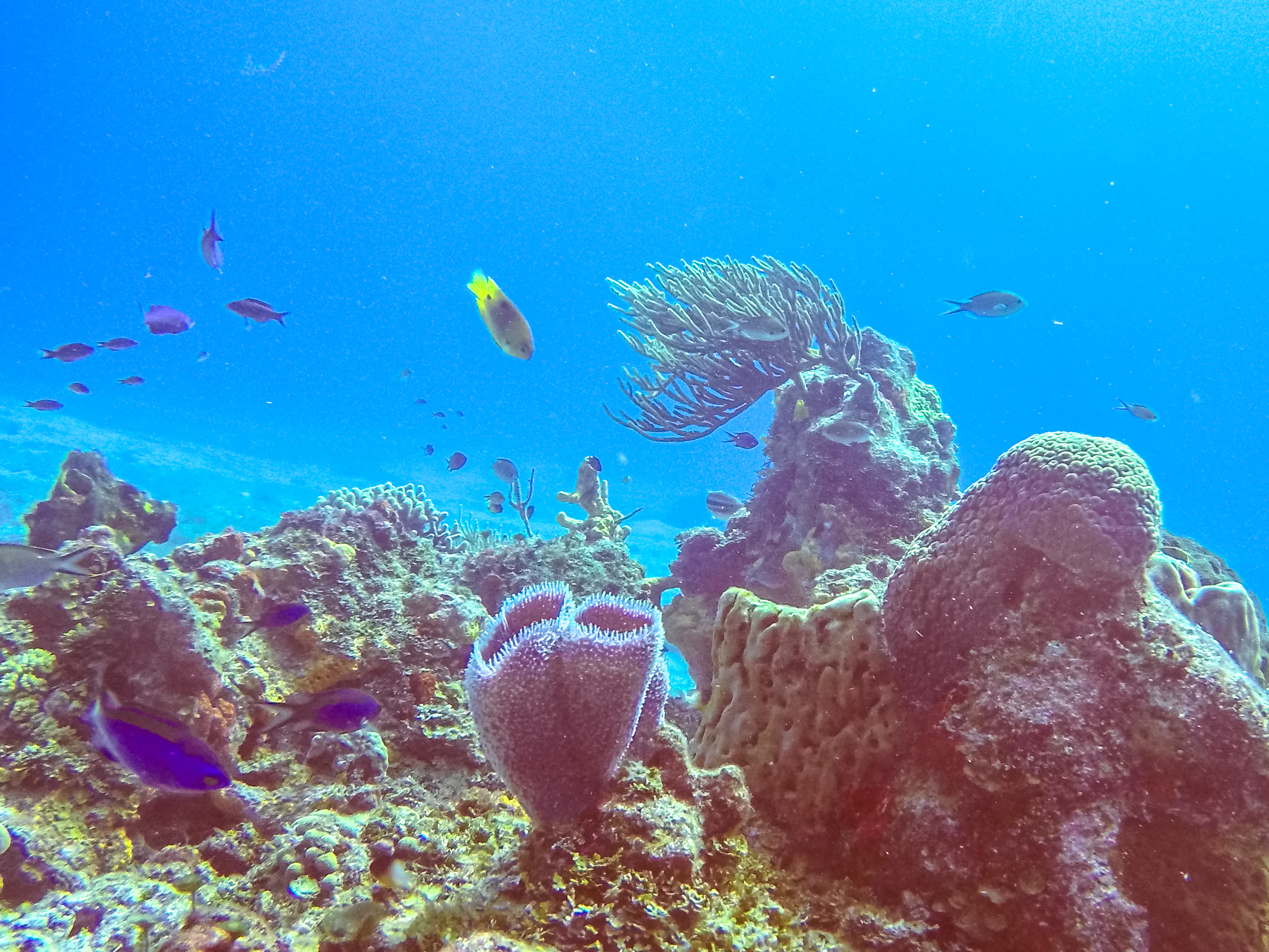
Coral reef formations with various fish swimming in clear blue ocean water
Vibrant coral reef ecosystem with diverse fish swimming in Cozumel National Park

Arrecifes de Cozumel National Park history and protected-area timeline

The formal protection of Cozumel's coral reefs began with a federal decree on June 11, 1980, which established a zone of refuge for the protection of marine flora and fauna along the western coast of the island. This initial protection measure encompassed the area between the high-tide line and the 50-meter isobath, running from the fiscal wharf to the southern point known as Punta Celarain. On July 19, 1996, under the administration of President Ernesto Zedillo Ponce de León, the area was elevated to national park status through an official decree published in the federal register, expanding the protected area to 11,987.87 hectares. This designation reflected the growing recognition of the reef's ecological importance and the need for coordinated conservation management. The park's significance was further acknowledged when it received Ramsar Convention designation on February 2, 2005, recognizing its importance as a wetland ecosystem. The park exists within the broader context of regional conservation efforts, including the Mesoamerican Barrier Reef System initiative signed in Tulum in 1997 by the presidents of Mexico, Guatemala, Honduras and the prime minister of Belize. Popular history often attributes the discovery of Cozumel's dive sites to Jacques Cousteau in 1960, but research has shown this to be a myth; the reef was actually documented by Mexican filmmaker René Cardona, and tourism development was sparked by an article in the American Automobile Association magazine.

Arrecifes de Cozumel National Park landscape and geographic character

The underwater landscape of Arrecifes de Cozumel is defined by the island's dramatic submarine topography. The western margin of Cozumel features a narrow insular platform that drops sharply between 20 and 30 meters depth, giving way to an almost vertical insular slope that descends to depths exceeding 400 meters. This terrace-like feature likely represents a Pleistocene erosion platform exposed alternately to submarine and subaerial conditions during marine transgressions. Along the southern and leeward edge of this submarine terrace, discontinuous reef formations create a kind of underwater parapet extending over nine kilometers. These deep reef structures consist of numerous relatively isolated formations of varying dimensions. The central and northern portions of the platform feature more continuous coral communities colonizing the calcium carbonate substrate. Above the water, Cozumel Island displays classic karst topography with sinkholes and cenotes formed by the collapse of cave roofs. The island lacks surface rivers because rainfall infiltrates directly through fractures in the limestone to the water table. Within the park boundaries, several coastal lagoons exist, including Laguna Colombia, El Chiquero, Chunchaka'ab, and Istacún at Punta Sur, and Laguna de Chankana'ab in the municipal park of the same name. These lagoons receive subterranean inputs of fresh and brackish water mixed with marine waters.

Arrecifes de Cozumel National Park ecosystems, habitats, and plant life

The marine ecosystem of Arrecifes de Cozumel represents one of the most biologically diverse and complex marine environments in the world's tropical seas. The coral reef community consists of both hard corals and soft corals (octocorals), forming intricate three-dimensional structures that support thousands of species. Beyond the coral formations themselves, the reef ecosystem includes zoanthids, polychaetes, actinarians, hydroids, sponges, crustaceans, mollusks, echinoderms, and numerous varieties of Caribbean fish. The reef communities extend from shallow waters ideal for snorkeling to mesophotic zones at 100 meters depth, creating multiple distinct habitat layers. Above the reefs, the island supports terrestrial vegetation including medium semi-deciduous forest, low deciduous forest, coastal scrub, and mangrove communities. The mangrove zones display distinct zonation patterns based on oxygenation, inundation, and salinity levels, with red mangrove dominating deeper, better-oxygenated lagoon edges, black mangrove on muddier, higher-salinity flats, and white mangrove further inland. The underwater environment is influenced by ocean currents, with the dominant north-equatorial and Guyana currents entering the Caribbean through the Lesser Antilles and becoming the Caribbean Current, while the channel between Cozumel and the mainland experiences a persistent south-to-north current averaging 1.5 knots.

Arrecifes de Cozumel National Park wildlife and species highlights

Arrecifes de Cozumel supports extraordinary marine biodiversity with more than 1,000 recorded species. The park provides critical habitat for several endangered marine species, most notably the loggerhead sea turtle (Caretta caretta) and hawksbill sea turtle (Eretmochelys imbricata), both of which nest on island beaches. The green turtle (Chelonia mydas) also inhabits these waters. The Cozumel splendid toadfish (Sanopus splendidus) is entirely endemic to the reefs surrounding this island and is listed as vulnerable by the IUCN, making it a flagship species for conservation. The reef fish community includes queen triggerfish, parrotfish including the queen parrotfish and rainbow parrotfish, butterflyfish, angelfish, damselfish, groupers, and morays such as the spotted moray and green moray. Larger species include nurse sharks, lemon sharks, tiger sharks, bull sharks, hammerhead sharks, and eagle rays. The invertebrate community features queen conch, various crab species, and the historically significant black coral, though populations of this deep-water coral declined significantly from the 1960s through the mid-1990s due to overharvesting and had not recovered by 2016. The terrestrial portion of the island supports 136 species including the Cozumel coati, Cozumel wrens, and the Cozumel thrush, though the park focuses primarily on marine protection.

Arrecifes de Cozumel National Park conservation status and protection priorities

Arrecifes de Cozumel holds significant conservation importance as part of the Mesoamerican Barrier Reef System, the second-largest reef complex globally. The park's Ramsar designation in 2005 acknowledges its wetland values, and it operates within the broader Isla Cozumel Biosphere Reserve framework established under UNESCO guidelines. The park's management objectives focus on protecting and conserving natural resources while restoring critical areas, establishing inter-institutional coordination for protection and surveillance, building consensus with stakeholder sectors, and balancing sustainable use with conservation. International conservation frameworks supporting the park include the Convention on Biological Diversity, the Tuxtla agreements for cooperation between Mexico and Central America, the Mesoamerican Biological Corridor project, and the Cartagena Convention for the protection and development of the marine environment in the Wider Caribbean. The park faces ongoing challenges from tourism pressure, with concerns about cruise ship terminal development prompting environmental review under the North American Agreement on Environmental Cooperation. The protection of endangered species including sea turtles, the endemic toadfish, queen conch, and black coral remains a central conservation priority.

Arrecifes de Cozumel National Park cultural meaning and human context

Cozumel Island holds deep cultural significance in Maya history, traditionally associated with the goddess Ixchel, the moon and fertility deity who was believed to dwell on the island. The island served as a pilgrimage destination for Maya women seeking fertility blessings, and the waters surrounding the island were considered sacred. While the park itself is primarily a marine protected area, the cultural heritage of Cozumel informs the island's identity and relationship with its marine environment. The park's creation in 1996 reflected growing awareness of the economic value of reef ecosystems, which support the tourism industry that forms the foundation of the local economy. Diving and snorkeling operations, some of which use artificial reef formations including a sunken naval vessel, provide employment for local communities. The integration of conservation objectives with sustainable tourism use defines the park's approach to balancing environmental protection with economic development on an island where marine resources are central to both livelihood and cultural identity.

Top sights and standout views in Arrecifes de Cozumel National Park

Arrecifes de Cozumel offers world-class diving along dramatic reef walls and coral gardens teeming with marine life. The park's exceptional visibility, warm waters year-round, and proximity to deep reef formations make it accessible for divers of all skill levels. The endemic Cozumel splendid toadfish represents a unique biological treasure found nowhere else on Earth. The park's position within the Mesoamerican Barrier Reef System connects it to the largest reef complex in the western hemisphere. Multiple named dive sites including Palancar, Chankanaab, Paradise, and Colombia offer varied experiences from gentle garden dives to drift diving along current-swept walls. The presence of sea turtles, shark species, and dense fish communities creates memorable encounters for visitors. The park's Ramsar designation and biosphere reserve status reflect its international recognition as a conservation priority area.

Best time to visit Arrecifes de Cozumel National Park

Cozumel's warm Caribbean climate ensures comfortable water temperatures throughout the year, ranging from 25°C to 32°C, making diving and snorkeling viable in any season. The dry season from March to April offers the clearest visibility and calmest sea conditions, though this coincides with higher tourist numbers. The wet season from June through November brings increased rainfall and the possibility of hurricanes, with August and September representing peak hurricane risk, but this period often offers fewer crowds and lower prices. The water temperature cools slightly in winter months to around 25°C, and while visibility may be slightly reduced, the winter months remain popular for diving. Turtle nesting occurs during summer months, and night-time turtle nesting observation is possible with special permits. The current patterns remain consistent year-round, averaging 1 to 2 knots, making drift diving a consistent experience. Consider that the park's marine environment is influenced by the Caribbean current system, and conditions can vary based on broader oceanic patterns.
Park guides

Targeted visitor questions and seasonal marine planning resources for reef exploration.

Arrecifes de Cozumel National Park Published Guide Preview and Focused Answers

Selected published guides provide focused answers regarding optimal marine conditions and seasonal planning parameters for the protected marine reserve. Practical visit planning resources help address key scheduling inquiries for marine expeditions across the coral ecosystems.
Monthly climate preview

Long term coastal weather normals and annual precipitation trends for the marine reserve

Arrecifes de Cozumel National Park Average Temperature and Weather by Month

Representative observations show a steady coastal climate with mean temperatures staying between 24.68 and 28.54 degrees Celsius alongside varying seasonal precipitation that reaches its peak of 6.62 millimeters per day in October. Reviewing the comprehensive twelve-month profile provides critical baseline data on daily maximums, minimums, and historical averages for the protected marine ecosystem.
Annual mean27 °C
25 °C29 °C
Jan25°
Feb25°
Mar26°
Apr27°
May28°
Jun28°
Jul28°
Aug29°
Sep28°
Oct27°
Nov26°
Dec25°
Warmest month
August

28.5 °C

Coolest month
January

24.7 °C

Wettest month
October

6.6 mm/day

Driest month
March

1.3 mm/day

Park location guide

Geography guide, regional context, and park location map for Arrecifes de Cozumel National Park

Arrecifes de Cozumel National Park park geography, regions, and map view in Mexico

Understand where Arrecifes de Cozumel National Park sits in Mexico through a broader geographic reading of the surrounding landscape, nearby location context, and its mapped position within the national park landscape.

How Arrecifes de Cozumel National Park fits into Mexico

Mexico, officially the United Mexican States, is a country in North America spanning the Sierra Madre mountain ranges, coastal plains, and tropical regions. It borders the United States to the north, Guatemala and Belize to the southeast, and has coastlines along the Pacific Ocean, Gulf of Mexico, and Caribbean Sea. With a population exceeding 130 million, Mexico is home to one of the world's most significant concentrations of Indigenous languages alongside Spanish.

Wider geography shaping Arrecifes de Cozumel National Park in Mexico

Mexico occupies a land area of 1,972,550 km2, making it the thirteenth-largest country in the world. The terrain is highly diverse, featuring the Sierra Madre Occidental and Sierra Madre Oriental mountain ranges, the Mexican Plateau, coastal lowlands along the Pacific and Gulf/Caribbean margins, and the Yucatan Peninsula. The country spans multiple climate zones from desert in the north to tropical rainforest in the south.

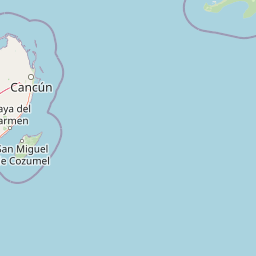
Map view of Arrecifes de Cozumel National Park

Use this park location map to pinpoint Arrecifes de Cozumel National Park in Mexico, understand its exact geographic position, and read its mapped placement within the surrounding landscape more clearly.

Pigeon | © OpenStreetMap contributors

Location context for Arrecifes de Cozumel National Park

Quintana Roo
Recorded earthquake history

Explore Historical Earthquake Records for Arrecifes de Cozumel National Park

Review the recorded seismic history associated with the marine landscape of Arrecifes de Cozumel National Park. This catalogue provides direct access to historical event data, including magnitude and epicentre location, as tracked in the region surrounding these protected reef systems through MoriAtlas.

Arrecifes de Cozumel National Park Earthquake History

Catalogued events

1 event

Strongest magnitude

Magnitude 4

Most recent event

Jan 12, 2015

This history includes earthquakes recorded inside the park or within 50 km of its borders

Explore underwater scenery, coral formations, and diverse marine habitats within this vital Mesoamerican Barrier Reef component.

Arrecifes de Cozumel National Park Photos: Visualizing Mexico's Stunning Caribbean Marine Landscapes and Protected Reef Ecosystems

Visually explore the distinct underwater terrain and vibrant marine habitats of Arrecifes de Cozumel National Park through this curated photography collection. Understanding the park's dynamic reef structures, diverse aquatic species, and Caribbean protected-area character is enhanced by reviewing authentic imagery of its unique environments.

Coral reef formations with various fish swimming in clear blue ocean water

A striped Splendid Toadfish with spines and white eye spots hiding in a coral reef crevice

Park atlas

Browse a Geographic Atlas of Nearby Reefs and Coastal Protected Landscapes in the Caribbean Sea

Explore Other Protected Marine Areas Near Arrecifes de Cozumel National Park

After exploring Arrecifes de Cozumel National Park, compare additional marine and coastal protected areas across the Yucatán Peninsula and the broader Caribbean Sea. Discover similar reef systems, aquatic ecosystems, and unique conservation landscapes to trace the geographic spread of protected environments in this vital region.
Biosphere reserveQuintana Roo
45 km away#1 closest

Southwest

Sian Ka'an Biosphere Reserve: Geographic Map and Protected Landscape Overview

Quintana Roo, Mexico coastal wetland and reef geography

Sian Ka'an Biosphere Reserve protects a diverse coastal environment in Quintana Roo, characterized by low-relief limestone terrain, flooded savannas, and the expansive Mesoamerican Barrier Reef. This entry provides a structured look at the reserve's protected land boundaries, petenes ecosystems, and integrated Maya archaeological corridors found throughout this tropical territory.

Area
5,281.47 km²
Established
1986
Relief
Lowland
Climate
Tropical
Wildlife reserveQuintana Roo
About 102 km away#2 closest

North

Área de Protección de Flora y Fauna Yum Balam: Protected Wildlife Reserve Atlas and Geography

A diverse coastal mosaic in northern Quintana Roo, Mexico.

Discover the mapped landscape of Área de Protección de Flora y Fauna Yum Balam, a critical wildlife reserve on the Yucatan Peninsula. This protected area features a unique combination of semideciduous tropical forests, inland mangrove lagoons, and freshwater wetlands, offering a comprehensive look at the ecological diversity of the northern Caribbean coast.

Area
1,540.52 km²
Established
1994
IUCN
VI
Relief
Lowland
National parkAmbergris Caye
About 249 km away#3 closest

South

Bacalar Chico National Park and Marine Reserve: Belize National Park & Marine Reserve Atlas

Explore Ambergris Caye's unique barrier island and reef geography.

Discover the extensive protected territory of Bacalar Chico National Park and Marine Reserve, a critical national park and marine reserve situated on Ambergris Caye, Belize. This protected area showcases a rich diversity of landscapes, from rare littoral forests and inland wetlands to vital coral reefs and sea grass beds integral to the Mesoamerican Barrier Reef System. Its unique geographic position and ecological significance make it a key destination for understanding Belize's conservation landscapes and mapped marine environments.

Area
62.8 km²
Established
1996
IUCN
IV
Relief
Lowland
Nature reserveYucatán
About 274 km away#4 closest

West

Cuxtal Ecological Reserve: Mapping the Protected Landscape and Geography of Yucatán

Nature reserve featuring critical groundwater recharge and historic cultural sites.

Cuxtal Ecological Reserve represents a significant protected area in Yucatán, Mexico, known for its strategic role in supplying water to Mérida. The landscape encompasses a vast expanse of seasonally dry low deciduous forest, interspersed with limestone karst formations, historic hacienda complexes, and archaeological remnants. This unique reserve provides essential habitats for migratory birds and local fauna while demonstrating the integration of environmental research, cultural heritage, and sustainable land management in a rapidly developing region.

Area
107.57 km²
Established
1993
Relief
Lowland
Climate
Tropical
National parkMexico
About 276 km away#5 closest

West

Dzibilchantún National Park: Protected Landscape in Mexico's Atlas

Mapped boundaries and regional geography for this national park.

Delve into the protected landscape of Dzibilchantún National Park, a significant national park situated within Mexico. This entry offers a detailed look at its geographic positioning, mapped park boundaries, and its role within the national atlas of protected areas. Understand the specific landscape context and regional geography that define Dzibilchantún National Park for comprehensive exploration.

Area
5.39 km²
IUCN
II
Relief
Lowland
Climate
Tropical
National parkMexico
About 348 km away#6 closest

Northwest

Arrecife Alacranes National Park: Protected Marine National Park Geography

Explore its mapped boundaries and regional significance.

Arrecife Alacranes National Park stands as a critical protected marine area within Mexico's national park system. This entity offers detailed geographic context for understanding protected landscapes, focusing on its mapped boundaries and the unique marine environment it encompasses. For those exploring national parks and their atlas representation, Arrecife Alacranes National Park provides a specific case study in marine conservation geography, highlighting its role within the broader Mexican landscape.

IUCN
II
Relief
Lowland
Scope
Marine
Water
Water-dominated
Biosphere reservePetén Department
350 km away#7 closest

Southwest

Maya Biosphere Reserve: Geographic Overview and Protected Landscapes in Petén

Tropical forest ecosystems and ancient archaeological mapping

Covering roughly one-fifth of Guatemala, the Maya Biosphere Reserve represents a pioneering model of zoned conservation. The landscape features a complex mosaic of lowland rainforests, savanna patches, and seasonal wetlands formed over a weathered limestone platform. This atlas summary examines the reserve's ecological boundaries, its vital role in protecting Mesoamerican biodiversity, and the concentration of pre-Columbian cities located across the Petén Department.

Area
21,602 km²
Established
1990
Relief
Mixed relief
Climate
Tropical
National parkCayo District
379 km away#8 closest

Southwest

Guanacaste National Park National Park: Explore its Protected Landscape and Geographic Setting

Mapped natural terrain and regional context within Cayo District.

Delve into the specifics of Guanacaste National Park, a protected national park located in the Cayo District of Belize. This detail page is designed for atlas exploration, offering insights into the park's geographic boundaries and its significance as a defined natural landscape. Understand how this protected area fits into the regional geography and contributes to the mapped natural heritage of Belize.

Area
0.2 km²
Established
1973
IUCN
II
Climate
Tropical

Common questions about visiting, size, designation, and location context for Arrecifes de Cozumel National Park

Arrecifes de Cozumel National Park FAQs for park facts, access, geography, and protected area context

Find quick answers about Arrecifes de Cozumel National Park, including protected-area facts, park geography, trail and visitor context, and how the park fits into its surrounding country and regional landscape.
MoriAtlas Explorer

Continue Your Protected Areas Search Across the Global Atlas

Deepen your exploration by continuing the structured search for national parks and protected areas worldwide. Utilize the comprehensive filtering capabilities to compare different conservation landscapes and refine your understanding of global park geography. Discover more about the distribution and characteristics of protected natural areas.

Global natural geography