
Lakes
Park geography
Detailed spatial data covering municipality distribution, terrain relief, and physical landscape classification.
Aukštaitija National Park Geography: Comprehensive Analysis of Boundaries and Landscape Features
This geographic profile details the physical scope of Aukštaitija National Park across three Lithuanian municipalities. It provides structured insights into the park footprint, encompassing 410.56 square kilometers of temperate forests and wetland habitats. The data identifies specific natural landmarks including Ladakalnis, regional capes, and geological stones, mapping their placement within the protected upland terrain.

Lithuania's oldest national park, protecting a vast lake-dotted forest landscape in the country's northeastern highlands
Aukštaitija National Park
Aukštaitija National Park is Lithuania's oldest national park, established in 1974 to protect one of the most ecologically significant landscapes in the Baltic region. Located in northeastern Lithuania, approximately 100 kilometers north of Vilnius, the park encompasses a complex of three geographic regions: the older Švenčionių-Naručio morainic highlands, the younger Aukštaičių highlands, and the sandy Žeimena plain that separates them. The park's defining character comes from its extraordinary density of lakes—over 120 scattered among forested hills and connected by streams—covering about 15.5% of its territory. More than 70% of the park is covered in woodland, predominantly pine forests, with some stands reaching 200 years old. The park protects a remarkable concentration of Lithuania's biodiversity, with nearly 59% of the country's plant species found within its boundaries despite covering less than 1% of the nation's area.
- Location
- Lithuania
- Park type
- National park
- Established
- 1974
- Area
- 410.6 km²
Location overview
National park boundaries within the Ignalina district municipality
Exploring the Geographic Location of Aukštaitija National Park in Lithuania
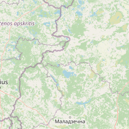
Aukštaitija National Park is situated in Lithuania within the Ignalina district municipality. The inland protected landscape features no coastal, marine, island, or transboundary zones.
- Countries
- Lithuania
- Regions
- Ignalina district municipality
- Primary location
- Lithuania
- Geographic setting
- Inland
Boundary and coordinates
Spatial scope and coordinate limits spanning 410.56 square kilometers
Geographic Boundary and Spatial Mapping of Aukštaitija National Park
Mapped boundary geometry traces the geographic outline of the park to establish clear spatial context. Derived measurements detail the total area of 410.56 square kilometers alongside coordinates and center point location.
- Boundary area
- 411 km²
- Boundary perimeter
- 159.7 km
- Northernmost point
- 55.4989° N
- Southernmost point
- 55.2001° N
- Easternmost point
- 26.1716° E
- Westernmost point
- 25.8157° E
- Geographic centre
- 55.3528° N, 26.0208° E
- North–south span
- 33.3 km
- East–west span
- 22.6 km
Terrain and natural features
Upland terrain classifications and recorded within park boundaries
Aukštaitija National Park Terrain and Named Natural Features
Upland terrain classifications define the protected landscape alongside multiple recorded lakes, wetlands, and peaks located within the park. Linked feature cards supply specific names, types, measurements, and spatial relationships for each recorded natural feature.
Selected named natural features
Lakes
Prūdas
Lakes
Šiekštelis
Lakes
Sventas
Lakes
Linkmenas
Reservoirs
Šventelės tv.
Environmental setting
Temperate upland settings, major water networks, and extensive forest cover
Aukštaitija National Park Environmental Classification and Physical Setting
Recorded landscape features and habitat types provide structured interpretive categories for reading the physical setting of Aukštaitija National Park. Stored classifications connect recorded environmental properties to related atlas destinations where available.
- Relief
- Upland
- Climate
- Temperate
- Water
- Major water bodies
- Forest cover
- Mostly forested
- Seasonality
- Year-round
Landscape features
Lakes · Rivers · Forest
Habitat types
Temperate coniferous forest · Wetland
Park atlas
Trace the regional spread of protected areas and compare similar natural landscapes in the Baltic.
Explore Other National Parks and Protected Areas Near Aukštaitija National Park in Lithuania
Continue exploring from Aukštaitija National Park by browsing a broader selection of national parks and protected areas across the surrounding Baltic region. Compare park geography, trace the spread of conservation landscapes, and discover how diverse ecosystems are protected in this part of Europe.
Nature reserveŠvenčionys District Municipality
About 1.6 km away#1 closest
Southwest

Kiauneliškio gamtinis rezervatas: Ancient Forest Landscapes and Protected Terrain Mapping
Nature reserve geography in Švenčionys District Municipality
Kiauneliškio gamtinis rezervatas protects 283 hectares of moist, sandy pine woodland characterized by glacial ridges and historic old-growth specimens. This site acts as an ecological reference for the Labanoro forest landscape, offering clear insights into the undulating lowland topography and rare interior habitats of eastern Lithuania.
- Area
- 2.83 km²
- IUCN
- Ia
- Relief
- Lowland
- Climate
- Temperate
Nature reserveŠvenčionys District Municipality
About 5.1 km away#2 closest
Southwest
Girutiškio gamtinis rezervatas Protected Area: Geographic Overview and Wetland Mapping
Labanoras Forest wetland complex in the Švenčionys District Municipality
Girutiškio gamtinis rezervatas is a strictly protected nature reserve occupying 1,400 hectares in eastern Lithuania. Defined by the Girutiškis and Beržalotas raised bogs, the area features a series of relict thermokarst lakes and dense pine forests. It remains a key site for boreal peatland conservation and hydrological study within the Baltic region, offering a rare glimpse into preserved wetland terrain.
- Area
- 14 km²
- IUCN
- Ia
Biosphere reserveAnykščiai District Municipality
39 km away#3 closest
Northwest
Šimonių Giria Biosphere Reserve in Anykščiai District Municipality, Lithuania
Protected forest massif and glacial landscape mapping
Šimonių giria stands as a prominent biosphere reserve in northern Lithuania, offering an expansive, pine dominated woodland defined by post glacial sands, extensive peat bogs, and a network of interior lakes. This structured overview details the park geographical features, from its role in the Natura 2000 network to its critical function as a biodiversity monitoring site within the Anykščiai District Municipality.
- Area
- 232.61 km²
- Established
- 2004
- Relief
- Lowland
- Climate
- Temperate
National parkMinsk Region
About 57 km away#4 closest
Southeast

Narachanski National Park: Belarus's Premier National Park and Lake District Atlas
Explore protected glacial terrain and diverse lake systems.
Narachanski National Park is the crown jewel of Belarus's lake district, a protected national park safeguarding a landscape defined by glacial origins and extensive freshwater systems. Centered around Lake Narach, the park's territory within Minsk Region showcases a varied terrain of moraine hills, depressions, and over 30 lakes. This atlas perspective highlights the park's unique geological features, extensive forests, and its role as a vital protected area for understanding regional geography.
- Area
- 933 km²
- Established
- 1999
- IUCN
- II
- Relief
- Lowland
National parkBelarus
About 59 km away#5 closest
Northeast
Braslaw Lakes National Park: Protected Glacial Lake Landscape Atlas
Mapped boundaries and terrain of a key Belarusian protected area.
Braslaw Lakes National Park presents a fascinating protected landscape defined by its extensive glacial lake chain, lush forests, and vital wetland ecosystems. As a significant natural region in northern Belarus, it offers valuable insights into lacustrine environments and glacially formed terrain. This park serves as a prime example of protected land within the Vitebsk Region, ideal for exploring its mapped geography, understanding its ecological importance, and appreciating the unique character of Eastern Europe's lake districts through a structured atlas lens.
- IUCN
- II
Biosphere reserveLithuania
About 74 km away#6 closest
West
Taujėnų, Užulėnio miškų biosferos poligonas: Protected Forest Landscapes of Lithuania
Central Baltic lowland conservation territory
Spanning central Lithuania, this biosphere reserve preserves a vast mosaic of deciduous, coniferous, and mixed forest lands. The territory supports high-quality bird habitats through disciplined forestry practices and the protection of complex wetland and peatland systems, making it a reference site for lowland forest conservation.
- Area
- 44.19 km²
- Established
- 2004
- Relief
- Lowland
- Climate
- Temperate
Biosphere reserveUkmergė District Municipality
About 83 km away#7 closest
West
Viliukų, Karpių miškai Biosphere Reserve: Regional Protected Area Geography and Maps
Broadleaved forests and wetland ecosystems in central Lithuania
Gain insights into the protected landscape of Viliukų, Karpių miškai in the Ukmergė District. This biosphere reserve provides a detailed view of lowland forest ecosystems, characterized by spruce and birch dominance within an undulating terrain that sustains rare insect and plant communities.
- Area
- 7.772 km²
- Established
- 2012
- Relief
- Lowland
- Scope
- Terrestrial

National parkLatgale
106 km away#8 closest
Northeast

Rāzna National Park: Protected Landscape and Regional Geography in Latgale
Explore the mapped terrain of Latvia's largest lake region.
Rāzna National Park, situated in the Latgale region, provides an essential focal point for understanding eastern Latvia's protected landscapes. This national park, recognized for its extensive glacial terrain and the significant Lake Rāzna, offers a distinct geographic profile. Users can explore its mapped boundaries, discover its role as a vital protected area, and understand its landscape context within the broader atlas of Latvia's natural heritage.
- Area
- 596.14 km²
- Established
- 2007
- IUCN
- II
- Relief
- Highland
MoriAtlas Explorer
Continue Mapping Aukštaitija National Park's Regional Geography and Protected Lands
Deepen your geographic understanding of Aukštaitija National Park by exploring its intricate mapped boundaries and the surrounding protected landscapes. MoriAtlas provides structured data to visualize this significant national park's place within the broader Baltic atlas, revealing connections between its unique terrain and regional conservation efforts. Continue your atlas exploration to understand the full scope of this protected natural area.
Browse next
Global natural geography
Explore related park routes
Explore MoriAtlas Global ParksBrowse All MoriAtlas ParksGlobal Park Map DiscoveryMoriAtlas: Browse All CountriesBrowse All MoriAtlas ContinentsNational Park Environment AtlasGrand Canyon National Park AtlasYellowstone National Park AtlasYosemite National Park Atlas and GeographySerengeti National Park AtlasGalápagos National Park Protected LandscapeBanff National Park Geography and AtlasKruger National Park Atlas EntryUluṟu-Kata Tjuṯa National Park AtlasExplore Uluru-Kata Tjuta National Park GeographyPlitvice Lakes National Park AtlasFiordland National Park Protected LandscapeGreat Smoky Mountains National Park AtlasAfghanistan National Parks and Protected AreasAlbania National Parks and Protected AreasAlgeria National Parks and Protected AreasAmerican Samoa National Parks and Protected AreasAndorra National Parks and Protected AreasAngola National Parks and Protected AreasAntarctica National Parks and Protected AreasAntigua and Barbuda Park List