
Mori Atlas logo
National parkBabiogórski Park Narodowy

Mapping the altitudinal vegetation zones and rugged Carpathian terrain of Southern Poland

Babiogórski Park Narodowy: A Deep Dive Into Protected Alpine Landscapes and Mountain Geography

Babiogórski Park Narodowy preserves a distinct mountain massif in the Western Carpathians of Lesser Poland Voivodeship, characterized by the iconic Diablak summit reaching 1725 meters. The landscape displays a textbook transition of altitudinal vegetation zones, climbing from lower montane beech-fir forests through dense spruce stands to dwarf mountain pine and open alpine grasslands. This protected territory provides essential habitat for large Carpathian mammals and rare endemic plant species, anchoring a vital ecological region.

mountain parkCarpathiansWestern Carpathiansaltitudinal vegetation zonationalpine zonespruce forest
A stylized digital illustration of a rocky mountain slope with grassy patches at dawn, featuring jagged rock formations in the foreground and distant hazy mountains under a pale sky.

Babiogórski Park Narodowy

National park

Park overview

Structured park overview, official facts, and landscape profile for Babia Góra National Park

Babia Góra National Park park facts, protected area profile, and essential visitor context

Review the core facts for Babia Góra National Park, including designation, size, terrain, visitor scale, habitats, and operating context in one park-focused overview.

About Babia Góra National Park

Babia Góra National Park is a national park in the Lesser Poland Voivodeship of southern Poland, where it preserves the principal Polish portion of the Babia Góra massif on the border with Slovakia and a small adjoining section of the Policy Range near Krowiarki Pass. At its heart is Diablak, the highest peak of the Beskid Żywiecki sub-range at 1725 meters, and the protected area includes both northern and southern flanks of the massif, giving the park a role in protecting an unusually complete sequence of Carpathian mountain habitats in a relatively compact footprint.

The defining natural feature of the park is its altitudinal vegetation zonation, often cited as a textbook example in Poland. Below roughly 1150 meters, the lower montane forest zone is dominated by beech, fir, and spruce, with exceptionally large firs including the famous Gruba Jodła, alongside characteristic understorey plants such as żywiec cebulkowy and czosnek niedźwiedzi. Between about 1150 and 1350 meters lies an upper montane spruce belt, which then gives way between about 1350 and 1650 meters to a striking zone of dwarf mountain pine (kosodrzewina) interspersed with mountain ash and specialized grassland species such as zawilec narcyzowy, goździk okazały, and lilia złotogłów. Above that, in the highest summit band from roughly 1650 meters to the peak, the park contains a true alp zone, the only one of its kind in the entire Beskidy mountain system, supporting rare species such as rogownica alpejska, an endemic of the Babia Góra massif.

Botanically, the park is exceptionally rich: roughly 650 species of vascular plants, nearly 280 moss species, and numerous lichens, algae, and liverworts have been recorded, including around 70 alpine plant species and 54 protected species. The park's symbolic plant is okrzyn jeleni, which has its strongest Polish stronghold here. Beyond plants, the park is a stronghold of typical Western Carpathian fauna, with brown bears, wolves, lynx, red deer, wild boar, otters, and a varied bird community including capercaillie, black grouse, hazel grouse, three-toed and white-backed woodpeckers, and the alpine accentor nesting near the summit.

The park's protected status has evolved through several phases. It was established in 1954, expanded in 1997 to its current extents, and the area was recognized internationally in 1977 as a UNESCO biosphere reserve under the Man and the Biosphere Programme. Visitor access today is restricted to marked trails maintained by the Polish Tourist and Sightseeing Society, and an Educational Center based in the park's headquarters village of Zawoja presents the area's natural values and supports an interpretive trail network across the park.

Quick facts and research context for Babia Góra National Park

Babia Góra National Park lies in southern Poland in the Lesser Poland Voivodeship, crossing the Sucha and Nowy Targ counties, and sits along the border with Slovakia. The park covers the Babia Góra massif and a part of the Policy Range near Krowiarki Pass, and its highest point is Diablak at 1725 meters in the Beskid Żywiecki. It was established in 1954 and expanded significantly in 1997, and in 1977 the area became a UNESCO-designated biosphere reserve under the Man and the Biosphere Programme. The park is administered from the village of Zawoja.

Protection and recognition

Documented terrestrial protection scope and historical designation data

Babiogórski Park Narodowy Protection Status and Designation History

Babiogórski Park Narodowy maintains a documented terrestrial protection status established in nineteen seventy-seven. This structured record outlines the designated management scope and historical conservation baseline without external recognition sources.

Protection details

Protection scope
Terrestrial
Designated year
1977
Transboundary protection
No
Buffer area
84.37 km²
Park context

Deeper park guide and search-rich context for Babia Góra National Park

Babia Góra National Park history, landscape, wildlife, and travel context

Explore Babia Góra National Park through its history, landscape character, ecosystems, wildlife, conservation priorities, cultural context, and seasonal travel timing in a structured park guide built for atlas discovery and search intent.

Why Babia Góra National Park stands out

Babia Góra National Park is especially known for the textbook arrangement of its altitudinal vegetation zones, climbing from mixed lower montane beech-fir forest through spruce-dominated upper montane forest and dwarf mountain pine scrub to a true alpine summit zone, the only such summit alp zone in the Beskidy ranges. It is distinguished as the home of rare Polish and Carpathian plant species such as okrzyn jeleni and the local endemic rogownica alpejska, and it holds the unusual combination of a Western Carpathian massif peaking near 1725 meters paired with a long-standing UNESCO biosphere reserve designation.
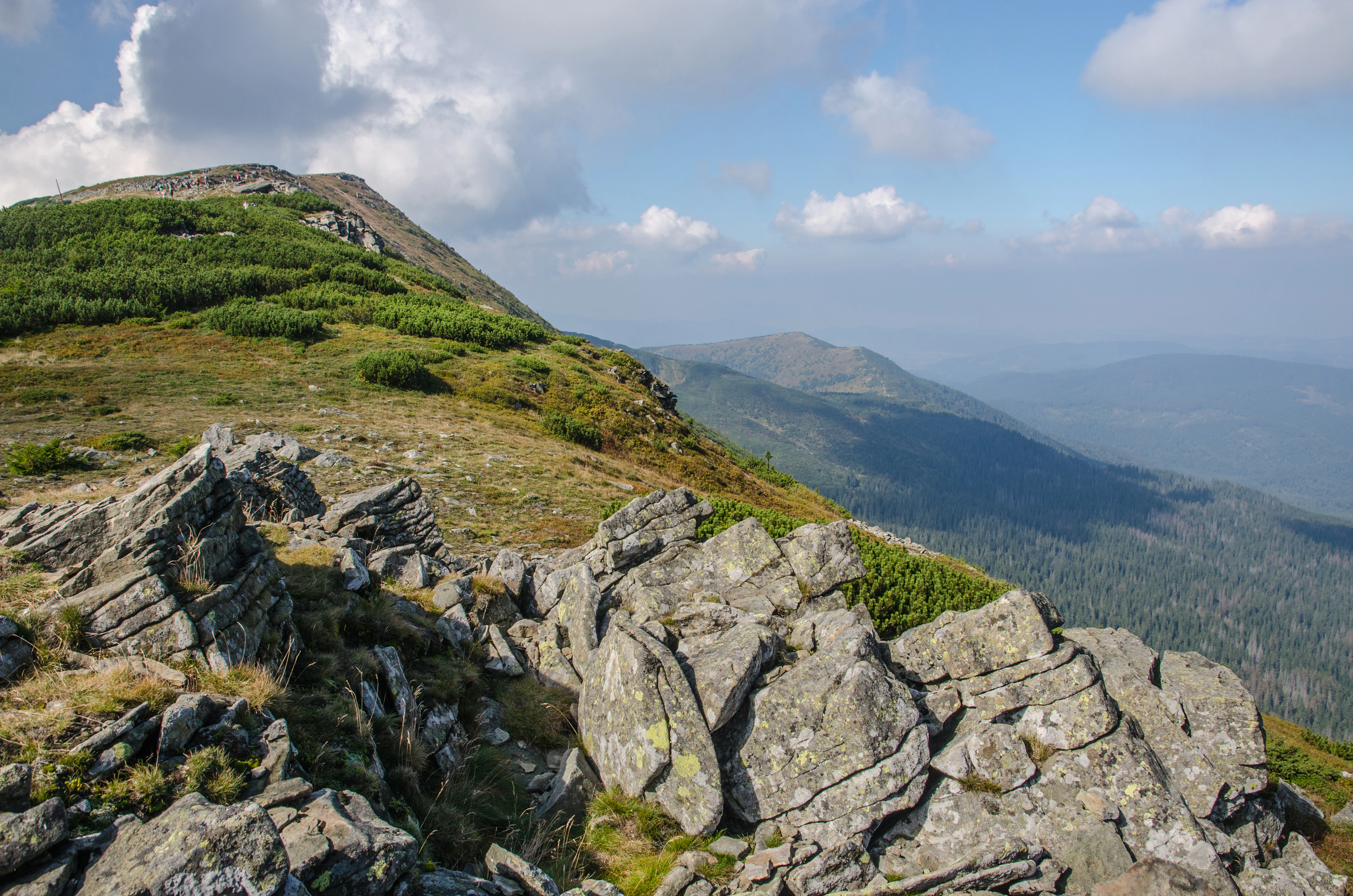
A landscape view of a rocky mountain ridge with low vegetation and distant forested slopes under a partly cloudy sky.
A wide view of the rugged ridgeline and mountain slopes in Babiogórski National Park.

Babia Góra National Park history and protected-area timeline

The park was created by a regulation of the Council of Ministers on 30 October 1954, effective from 1 January 1955. Initially, it covered about 16.37 square kilometers, and within its early boundaries a strict reserve of roughly 1049.89 hectares and a partial reserve of about 624.89 hectares were defined. The motivation for the park's creation was the exceptionally clear arrangement of vegetation zones on Babia Góra, the presence of rock plant communities, and the fact that this was the only known Polish location of two highly distinctive species, okrzyn jeleni and rogownica alpejska, and the only site in the Beskidy with a true summit alp zone and a network of landslide ponds in the higher parts of the mountain.

In 1977, Babia Góra within the park's borders was given biosphere reserve status and included in UNESCO's Man and the Biosphere Programme, cementing its international profile. After more than two decades of effort to expand the park, a 1997 regulation by the Council of Ministers enlarged the park area to about 3391.55 hectares and created a surrounding buffer zone of about 8437 hectares, giving the protected landscape its present extent.

Babia Góra National Park landscape and geographic character

Babia Góra National Park is a mountain landscape of medium elevation that nonetheless feels distinctly alpine at its summit. The terrain is dominated by the massive ridge of Babia Góra itself, which separates the Polish valleys of the northern slopes from the Slovak Orava side, with the summit Diablak at 1725 meters serving as a sharp high point above the surrounding Carpathian ridges. The park also incorporates a southern flank near Krowiarki Pass and parts of the adjacent Policy Range, producing a landscape of rounded crests, deeply incised stream valleys, cirque-like hollows, and a sequence of landslide pools that lie high on the mountain.

From the lower elevations up to about 1150 meters, the slopes are cloaked in continuous mixed forests of beech, fir, and spruce, while above that the canopy simplifies into dense spruce forest. Between about 1350 and 1650 meters, the forest gives way to the distinctive band of krummholz-like dwarf mountain pine interspersed with grassy openings, and above 1650 meters the mountain rises into open alpine-style grasslands and rocky terrain with scattered tarns. This layered structure is the most visually striking geographic feature of the park and is visible from neighboring peaks such as Sokolica.
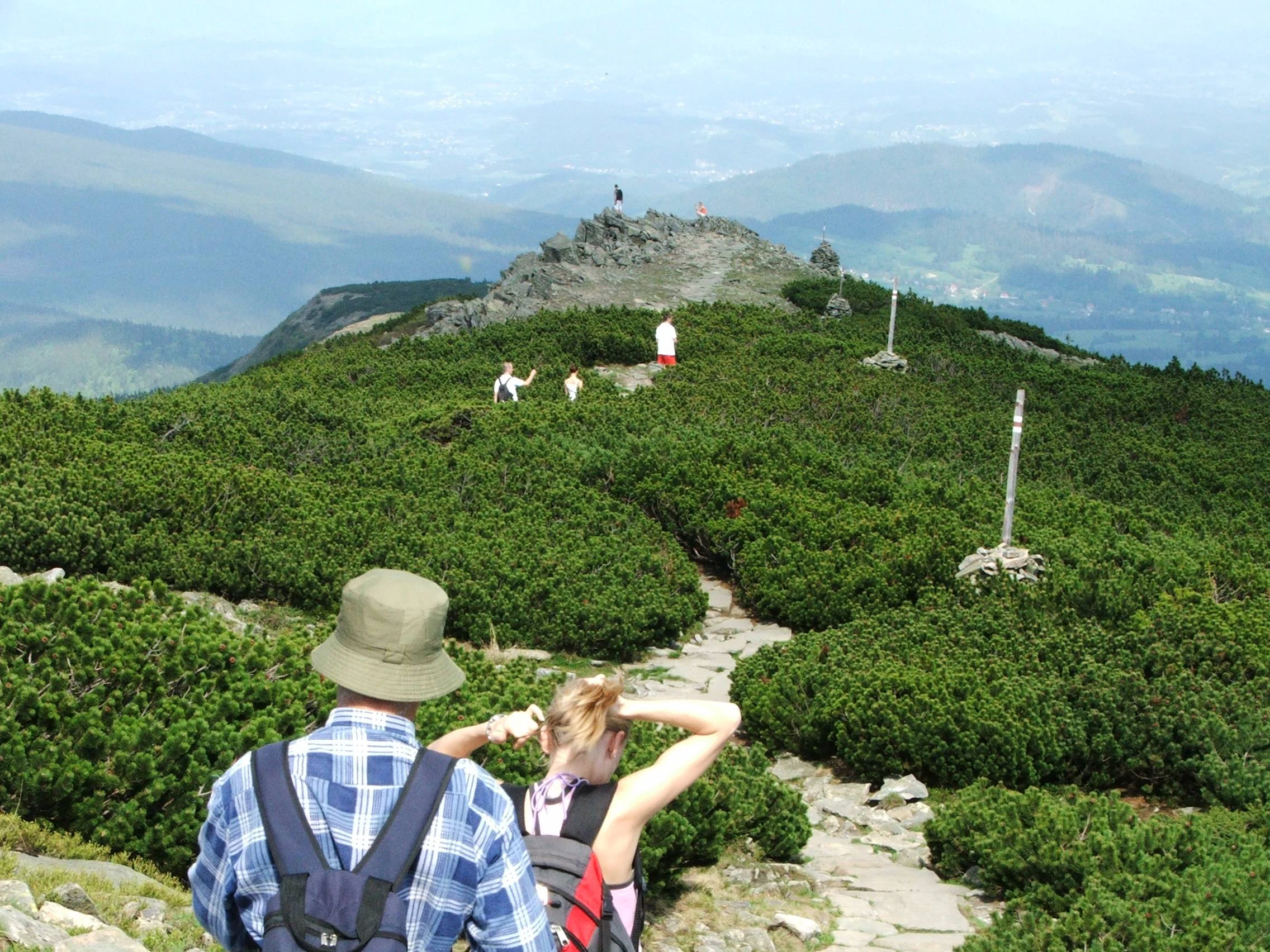
Rear view of two hikers on a stone trail, with a sprawling landscape of low, dense mountain pine shrubs and a distant rocky peak visible in the background under a hazy sky.
Hikers traversing the rocky trails amidst the dense mountain pine zone of Babia Góra.

Babia Góra National Park ecosystems, habitats, and plant life

The park protects a remarkably complete and clearly stratified sequence of Carpathian mountain ecosystems. The lowest zone features a productive lower montane forest of beech, silver fir, and spruce with large old trees, while the middle elevations support a relatively pure upper montane spruce forest. Above the treeline analogue, a thick dwarf mountain pine belt transitions the landscape into an alpine zone unique in the Beskidy, where alpine grasses, sedges, and rare endemic forbs grow amid exposed rock and small landslide ponds.

Across these zones, the park hosts around 650 vascular plant species, around 70 species of higher-mountain plants, and 54 species under formal species protection in Poland, alongside almost 280 moss species and diverse lichen, algae, and liverwort communities. The botanical richness is closely tied to the abrupt ecological transitions on the massif, which allow species of different climatic affinities to coexist unusually close together. Theabatic landslide ponds and small tarns add aquatic microhabitats at surprisingly high elevations, supporting specialized amphibian and invertebrate communities.
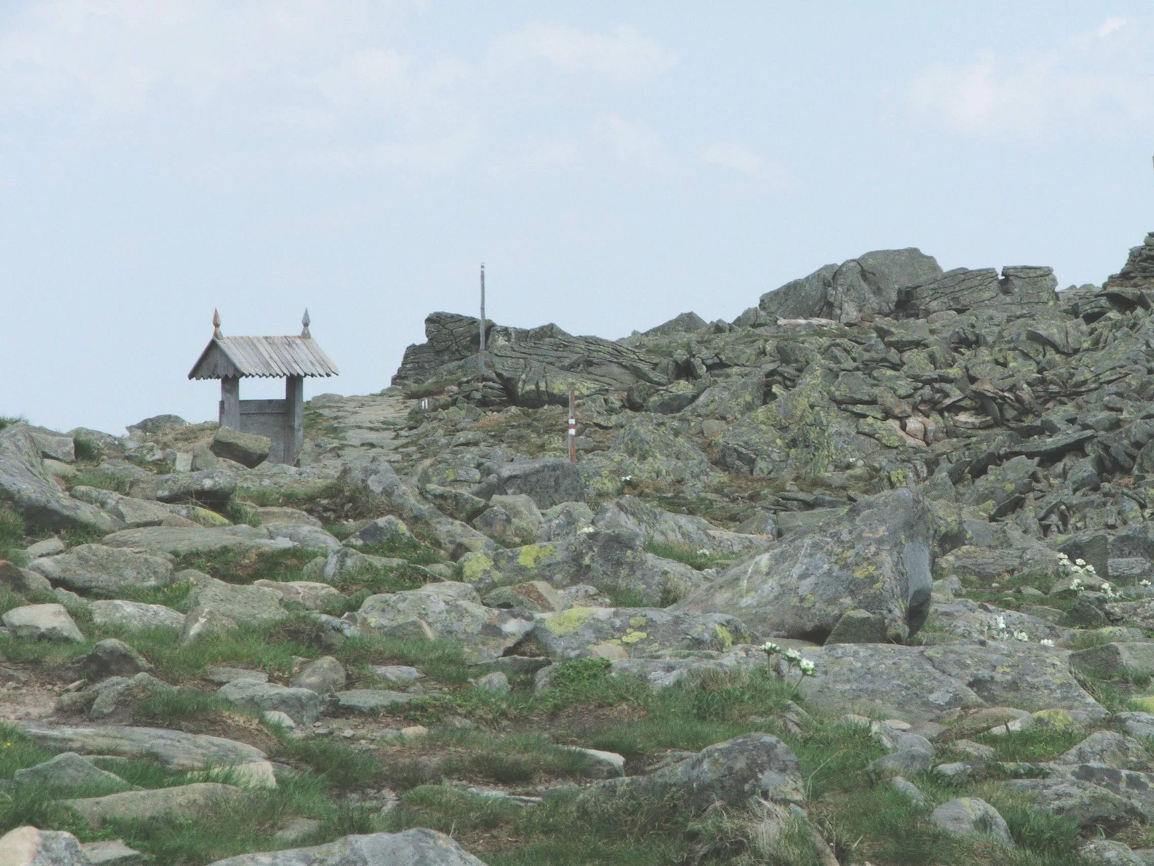
A rocky, uneven mountain slope covered in grey stones and patches of low vegetation, with a small wooden structure with a gabled roof visible in the distance.
Rocky terrain and a small wooden shelter near the summit of Babia Gora.

Babia Góra National Park wildlife and species highlights

The park's fauna reflects the wildlife of the Western Carpathians in a setting where large forest complexes and varied habitats have been preserved from excessive human pressure. Mammals are particularly notable: the park hosts permanent populations of large carnivores including brown bear, wolf, and Eurasian lynx, alongside red deer, roe deer, and wild boar, with moose occasionally wandering in from the Orava-Nowy Targ Basin. Smaller mammals are similarly diverse, including badger, otter, pine marten, stone marten, weasel, polecat, red squirrel (in both normal and melanistic forms), the dormouse species of higher forests, the edible dormouse reaching the dwarf mountain pine belt, and the rare garden dormouse, for which Babia Góra National Park is the only known site in Poland.

Birdlife is unusually well documented for a Carpathian park of this size. Historical surveys counted over one hundred species with nearly eighty breeding, while early twenty-first century work has put the number at 115 to 119 species with around one hundred breeding. Notable species include capercaillie in the upper montane forest, black grouse reaching the dwarf mountain pine belt, hazel grouse in the lower forests, and owls such as the Ural owl, long-eared owl, eagle owl, and tawny owl. Woodpeckers are well represented, including the rare three-toed and white-backed woodpeckers, while high-elevation specialties include the alpine accentor and the very rare snow finch, the two highest-nesting bird species in the park.

Reptiles include six species, with the adder, the rarer smooth snake, and the grass snake among snakes and three lizard species including the viviparous lizard reaching the dwarf mountain pine zone. Seven amphibian species occur, with alpine newt, Carpathian newt, and fire salamander all notable for breeding at unusually high elevations in small water bodies such as Marków Stawek and the Orawski ponds. Only two fish species are present because most park waters are small cold streams or fluctuating tarns, while invertebrate diversity is extraordinarily high at roughly 3,500 recorded species, including about 1,500 beetles and 92 mollusks.
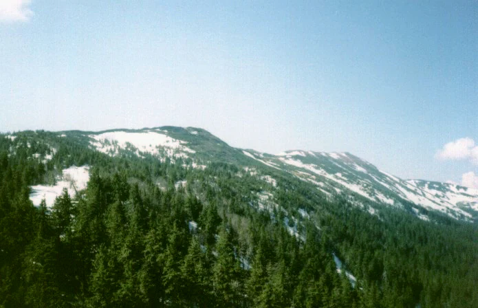
A wide view of the Babia Góra mountain range, covered in dense coniferous forest with patches of snow remaining on the upper slopes.
The Babia Góra massif as seen from Sokolica.

Babia Góra National Park conservation status and protection priorities

Babia Góra National Park is one of the most ecologically significant protected areas of Poland's Western Carpathians, not only for its strictly protected core but also for its role within the larger UNESCO-recognized biosphere reserve. The combination of long-standing national park protection, transboundary coordination with the Slovak Horná Orava Landscape Park, and biosphere reserve designation under UNESCO's Man and the Biosphere Programme gives the area layered security across national and international frameworks.

Conservation importance centers on the preservation of a complete altitudinal vegetation gradient from montane beech-fir forest through spruce forest, dwarf mountain pine, and alpine zone, a sequence that elsewhere in the Beskidy is absent or truncated. The park safeguards populations of rare and endemic plant species such as rogownica alpejska and the symbolic okrzyn jeleni, maintains viable populations of large Carpathian carnivores including brown bear, wolf, and lynx, and protects a network of high-elevation landslide ponds that support specialized amphibian communities. The strict protection, active protection, and landscape protection zones within the park reflect a graduated management approach that balances ecological preservation with modest public use along marked trails.

Babia Góra National Park cultural meaning and human context

Although the park's identity is primarily natural, the surrounding landscape carries centuries of pastoral and forestry culture. The park's headquarters in the village of Zawoja, one of the longest linear villages in this part of Poland, anchors a regional community whose traditional life has long been intertwined with the Babia Góra massif, and the park's Educational Center in Zawoja presents these natural and cultural values together. Historically, Babia Góra also retains traces of early twentieth-century wildlife encounters; the park's museum holds the preserved pelt of the last European wildcat killed on the Orava slopes of the mountain in 1936, a cultural artifact that anchors the place of local hunting history within the park's heritage narrative.

Top sights and standout views in Babia Góra National Park

Babia Góra National Park's standout qualities come together in the towering Diablak summit at 1725 meters, the only true alpine zone in the entire Beskid chain, and the unbroken vegetation zonation that climbs from beech-fir forest through spruce and dwarf mountain pine to this open summit. Reinforcing the experience is the park's UNESCO biosphere reserve status since 1977, populations of large Carpathian mammals including brown bear, wolf, and lynx, the symbolic okrzyn jeleni in its strongest Polish stronghold, and the rare endemic rogownica alpejska on the Babia Góra massif. With over one hundred thousand visitors a year, the park is both an ecological cornerstone and a major mountain recreation destination in southern Poland.

Best time to visit Babia Góra National Park

The most rewarding time to experience Babia Góra National Park is in summer and early autumn, when the altitudinal vegetation bands are fully visible from the beech-fir forests through the flowering dwarf mountain pine zone up to the alpine summit, and when the meadows of the higher slopes come into bloom. Spring offers fresh forest understorey and bird activity across the lower forests, while autumn emphasizes the redent color of beech stands and the clear visibility across the Western Carpathians from the summit. Winter brings snow cover that has recently opened limited backcountry skiing access along marked trails, though the park's strict visitor rules remain tied to trail use for the protection of fauna.

Monthly climate preview

Long-term temperature ranges and monthly precipitation recorded at representative park elevations

Babiogórski Park Narodowy Climate Normals and Annual Weather Patterns

Representative coordinates record measured monthly temperature swings from deep sub-zero winter minimums to warm summer maximums alongside varying precipitation levels throughout the year. Reviewing the complete twelve-month climate profile reveals comprehensive statistical norms for temperature and moisture distribution across the protected landscape.
Annual mean6 °C
-5 °C17 °C
Jan-5°
Feb-4°
Mar
Apr
May11°
Jun15°
Jul17°
Aug17°
Sep12°
Oct
Nov
Dec-3°
Warmest month
July

16.9 °C

Coolest month
January

-4.9 °C

Wettest month
July

4.3 mm/day

Driest month
December

1.9 mm/day

Park location guide

Geography guide, regional context, and park location map for Babia Góra National Park

Babia Góra National Park park geography, regions, and map view in Poland

Understand where Babia Góra National Park sits in Poland through a broader geographic reading of the surrounding landscape, nearby location context, and its mapped position within the national park landscape.

How Babia Góra National Park fits into Poland

Poland, officially the Republic of Poland, is a Central European country spanning from the Baltic Sea in the north to the Carpathian Mountains in the south. It borders Germany, Czech Republic, Slovakia, Ukraine, Belarus, Lithuania, and Kaliningrad Oblast. The country has a temperate climate, diverse landscapes, and is known for its rich history, cultural heritage, and strong economic position within the EU.

Wider geography shaping Babia Góra National Park in Poland

Poland occupies 312,696 km2 in Central Europe, extending from the Baltic Sea coast in the north to the Sudetes and Carpathian Mountains in the south. It borders Germany to the west, Czech Republic and Slovakia to the south, Ukraine and Belarus to the east, and Lithuania and Kaliningrad Oblast to the northeast. The landscape includes lowland plains, uplands, and mountain ranges.

Map view of Babia Góra National Park

Use this park location map to pinpoint Babia Góra National Park in Poland, understand its exact geographic position, and read its mapped placement within the surrounding landscape more clearly.

Pigeon | © OpenStreetMap contributors

Location context for Babia Góra National Park

Lesser Poland Voivodeship
Natural feature types

Explore the Natural Landscapes and Landmarks of Babiogórski Park Narodowy

Navigate the complete collection of named natural features found within the Babiogórski Park Narodowy landscape. This MoriAtlas index provides essential geographic context for the mountain ridges, forest zones, and high alpine areas of this protected Carpathian region.
Recorded earthquake history

Review the Babiogórski Park Narodowy Earthquake History Catalogue

Examine the record of documented seismic events associated with the Babiogórski Park Narodowy massif. MoriAtlas provides a clear view of historical earthquake data, including magnitude and location metrics, for anyone interested in the regional seismic context of the Western Carpathians.

Babiogórski Park Narodowy Earthquake History

Catalogued events

12 events

Strongest magnitude

Magnitude 4.8

Most recent event

Jan 29, 2005

This history includes earthquakes recorded inside the park or within 50 km of its borders

Visual exploration of Western Carpathian terrain and vegetation zonation

Babiogórski Park Narodowy Photos and Landscape Scenery

Visual records illustrate the rugged mountain terrain and layered altitudinal vegetation zones across Babiogórski Park Narodowy. Protected area photography reveals the distinct character of beech-fir forests, dwarf mountain pine scrub, and alpine summits.

A landscape view of a rocky mountain ridge with low vegetation and distant forested slopes under a partly cloudy sky.

A dirt hiking path leads into a dense, misty forest with tall trees and a trail marker visible on a tree trunk.

Rear view of two hikers on a stone trail, with a sprawling landscape of low, dense mountain pine shrubs and a distant rocky peak visible in the background under a hazy sky.

A rocky, uneven mountain slope covered in grey stones and patches of low vegetation, with a small wooden structure with a gabled roof visible in the distance.

A wide view of the Babia Góra mountain range, covered in dense coniferous forest with patches of snow remaining on the upper slopes.

Park atlas

Discover adjacent mountain reserves and regional protected landscapes across the Western Carpathians

Exploring Parks Near Babiogórski Park Narodowy and Surrounding Protected Areas

Comparing nearby national parks reveals how surrounding mountain ranges share similar alpine terrain and forest zonation with Babiogórski Park Narodowy. Extending geographic research across adjacent transboundary protected areas provides deeper context into the broader ecology of the Western Carpathians.
Watercolor painting of rolling green hills and distant forested mountains under a light sky
National parkLesser Poland Voivodeship
Park boundaries overlap#1 closest

Southeast

Babia Góra National Park: Carpathian National Park with Mapped Terrain and Unique Flora

Explore protected landscapes and regional geography in Lesser Poland Voivodeship.

Babia Góra National Park, a significant protected area in Poland's Carpathian Mountains, offers a distinct atlas exploration experience. Its landscape is defined by the prominent Babia Góra massif, featuring complete altitudinal vegetation zones, rare endemic plant species, and notable terrain characteristics. As a UNESCO biosphere reserve, it provides valuable insights into Carpathian ecosystems and regional geographic context, making it a key destination for structured discovery of protected lands and natural landscapes.

Area
33.92 km²
Established
1954
IUCN
II
Visitors
81K annual
Protected landscapeSilesian Voivodeship
7.7 km away#2 closest

West

Żywiecki Park Krajobrazowy: Geographic Atlas and Protected Landscape Overview

A detailed look at Beskid mountain terrain and Silesian regional geography.

Żywiecki Park Krajobrazowy encompasses a diverse mountain environment within the Silesian Voivodeship, where parallel ridges and deeply incised valleys create a complex dendritic structure. This protected landscape is marked by its transition from dense beech and spruce forests to high-mountain zones, featuring unique karst formations and significant waterfall systems along its river networks.

Area
358.7 km²
Established
1986
Relief
Mountain
Climate
Temperate
Nature reserveLesser Poland Voivodeship
15 km away#3 closest

Southeast

Torfowiska Orawsko-Nowotarskie Nature Reserve: Mapped Geography and Protected Bog Landscapes

A vital peatland complex within the Polish Carpathian foothills.

Torfowiska Orawsko-Nowotarskie stands as one of the most comprehensive peatland conservation sites in the Polish Carpathians. Its landscape is defined by dome-shaped raised bogs, marshy pools, and boggy woodlands that occupy the broad intermontane basin of the Kotlina Orawsko-Nowotarska, offering a unique look at post-glacial wetland ecology.

Area
82.667 km²
Established
2007
Relief
Upland
Climate
Temperate
A horizontal watercolor painting depicting soft, layered green hills and purple-toned mountain ridges in the distance, with a foreground of stylized evergreen trees.
Protected landscapeSilesian Voivodeship
25 km away#4 closest

West

Park Krajobrazowy Beskidu Śląskiego: Geographic Atlas of Protected Silesian Beskid Landscapes

Mapped mountain ridges, river headwaters, and protected forest reserves.

Gain insight into the ecological and structural character of Park Krajobrazowy Beskidu Śląskiego. This resource documents the park's flysch geological formations, rare cave systems, and the hydrological significance of the Vistula River headwaters within the Silesian Beskids.

Area
386.2 km²
Established
1998
Relief
Mountain
Climate
Alpine
Nature reserveLesser Poland Voivodeship
29 km away#5 closest

East

Ostoja Gorczańska: Protected Area Mapping and Carpathian Mountain Geography in Lesser Poland

Ecological corridors across the Gorce and Beskid Wyspowy ranges

Covering nearly 18,000 hectares, Ostoja Gorczańska represents a significant biodiversity reservoir in the Polish Carpathians. The site integrates multiple protection frameworks, safeguarding varied habitats from subalpine grasslands to dense montane forests and peatland depressions. Use this resource to examine the structural connectivity of these mountain units and the expansive wilderness corridors found within the Lesser Poland Voivodeship.

Area
179.979 km²
Established
2008
Relief
Mountain
Climate
Temperate
A horizontal watercolor illustration depicting rolling, soft green mountains under a pale pink sky, with simple plant motifs in the foreground.
Protected landscapeSilesian Voivodeship
29 km away#6 closest

Northwest

Park Krajobrazowy Beskidu Małego: Geographic Overview and Protected Mountain Landscape

Twin ridges and sandstone terrain in the western Carpathians

Trace the geography of Park Krajobrazowy Beskidu Małego, a protected landscape in southern Poland covering 257 square kilometers of the Little Beskids. This detailed atlas entry provides insights into the park's twin-ridged structure, sandstone bedrocks, and the ecological significance of its nature reserves and valley corridors located within the Silesian Voivodeship.

Area
257.7 km²
Established
1998
Relief
Mountain
Climate
Temperate
Watercolor painting showing rolling green hills, forests, and distant mountains under a pale sky
National parkLesser Poland Voivodeship
30 km away#7 closest

East

Gorce National Park: A Comprehensive Geographic Profile and Protected Area Analysis

Mountain meadows and Carpathian forest landscapes in southern Poland

Gorce National Park preserves an essential segment of the Western Beskids, offering a look into the region's arched ridges and forested terrain. The area serves as a critical protected landscape featuring significant biodiversity, ancient woodland, and open mountain meadows that distinguish the local geography of the Lesser Poland Voivodeship.

Area
70.3 km²
Established
1981
IUCN
II
Visitors
80K annual
A horizontal watercolor illustration depicting rolling, layered mountains in shades of purple, red, and soft green, with a foreground of green evergreen forest silhouettes against a white background.
National parkLesser Poland Voivodeship
30 km away#8 closest

East

Gorczański Park Narodowy: Protected Mountain Geography in Lesser Poland Voivodeship

Carpathian forest and mountain clearing atlas

Gorczański Park Narodowy serves as a critical protected landscape in the Polish Carpathians. This atlas entry details the park's topography, including the dominant Turbacz massif, extensive forest corridors, and the ecological significance of its seepage meadows and high-altitude grasslands.

Area
70.3 km²
Established
1981
Visitors
92K annual
Relief
Mountain

Common questions about visiting, size, designation, and location context for Babia Góra National Park

Babia Góra National Park FAQs for park facts, access, geography, and protected area context

Find quick answers about Babia Góra National Park, including protected-area facts, park geography, trail and visitor context, and how the park fits into its surrounding country and regional landscape.
MoriAtlas Explorer

Continue Your Protected Areas Search Across the Global Atlas

Deepen your exploration by continuing the structured search for national parks and protected areas worldwide. Utilize the comprehensive filtering capabilities to compare different conservation landscapes and refine your understanding of global park geography. Discover more about the distribution and characteristics of protected natural areas.

Global natural geography