Mori Atlas logo
Nature reserveBärluch

Analyzing the post-glacial fens and mosaic woodland terrain of this protected German wetland

Bärluch Nature Reserve: Geographic Context and Mapped Protected Landscapes in Brandenburg

(Naturschutzgebiet Bärluch)

Bärluch functions as a critical protected nature reserve, characterized by shallow post-glacial depressions and lowland fens formed over thousands of years. This 160-hectare habitat features a patterned mosaic of swamp woodland, mixed oak forest, and wet meadows that support moisture-dependent birdlife and specialized amphibians. Situated within the broader Luckenwalder Heide region, the reserve forms an essential link in the southern Brandenburg conservation network, maintained through active species and habitat management.

wetlandfenswamp forestoak forestwet meadowlowland reserve

Bärluch

Nature reserve

Park overview

Structured park overview, official facts, and landscape profile for Bärluch

Bärluch park facts, protected area profile, and essential visitor context

Review the core facts for Bärluch, including designation, size, terrain, visitor scale, habitats, and operating context in one park-focused overview.

About Bärluch

Bärluch sits in the gently undulating lowlands of southern Brandenburg, an area shaped during and after the last glaciation when meltwater processes left behind a mix of sandy uplands, glacial spillway channels, and shallow basins that later filled with organic material. The reserve occupies one of these basins and its surrounding slopes, producing an environment where dry forest stands on higher ground while permanently damp or periodically flooded conditions dominate the lower areas.

The protected landscape is best understood as a mosaic rather than a single habitat type. On the drier soils, mixed oak forests anchor the vegetation, while the wetter depressions support alder-dominated swamp woodland, open lowland fens, scattered bog pools, and wet meadows. This structural diversity is the core of the reserve's ecological value, because it allows a much wider range of species to coexist than would be possible in a uniform landscape. The mosaic also buffers the system against disturbances; when one habitat type is stressed, others maintain the overall ecological continuity.

Bärluch is positioned within the broader natural region known as the Luckenwalder Heide, and it belongs administratively to the larger Naturpark Nuthe-Nieplitz, a regional landscape that ties together many smaller nature reserves, lowland rivers, and forest complexes south of Berlin. The nearby Nuthe river, which flows along the eastern edge of the reserve, connects Bärluch hydrologically to the wider riverine system and helps maintain the wet conditions that define the site. Just a short distance to the southeast lies the related reserve Rauhes Luch, reinforcing the sense that Bärluch is part of a clustered network of small wetland protected areas rather than an isolated patch.

Quick facts and research context for Bärluch

Bärluch is a nature reserve (Naturschutzgebiet) located in Brandenburg, Germany, within the municipality of Nuthe-Urstromtal in Landkreis Teltow-Fläming. Established on 18 September 2000, it carries the official designation number 1584 and is registered in the World Database on Protected Areas under WDPA-ID 318165. The reserve falls within IUCN Category IV, reflecting its role in targeted habitat and species management. Geographically it belongs to the Luckenwalder Heide natural region and lies between the villages of Hennickendorf and Märtensmühle, with the Nuthe river flowing along its eastern side.

Protection and recognition

Terrestrial protected area records established in the year 2000

Bärluch Protection Status and Documented Conservation Designation

Bärluch holds documented terrestrial protection status established in the year 2000 within official conservation registers. Designated records compile administrative designation history and management scope for analytical natural area research.

Protection details

Protection scope
Terrestrial
Designated year
2000
Transboundary protection
No
WDPA ID
318165
Park context

Deeper park guide and search-rich context for Bärluch

Bärluch history, landscape, wildlife, and travel context

Explore Bärluch through its history, landscape character, ecosystems, wildlife, conservation priorities, cultural context, and seasonal travel timing in a structured park guide built for atlas discovery and search intent.

Why Bärluch stands out

Bärluch is best known for its post-glacial wet-depression landscape, where lowland fens have formed in shallow basins between oak-dominated forests and wet meadows. The reserve is particularly valued for its breeding bird fauna, which includes rare, threatened, and disturbance-sensitive species that depend on the undisturbed character of the swamp forests and open fen areas. The area is also notable for its richness in moisture-dependent wildlife more broadly, including threatened amphibians and reptiles, as well as a butterfly fauna tied to wetland and forest-edge habitats. The combination of swamp woodland, mixed oak forest, wet grassland, and open bog pools gives the reserve a layered ecological structure that is increasingly rare in intensively managed lowlands of central Europe.
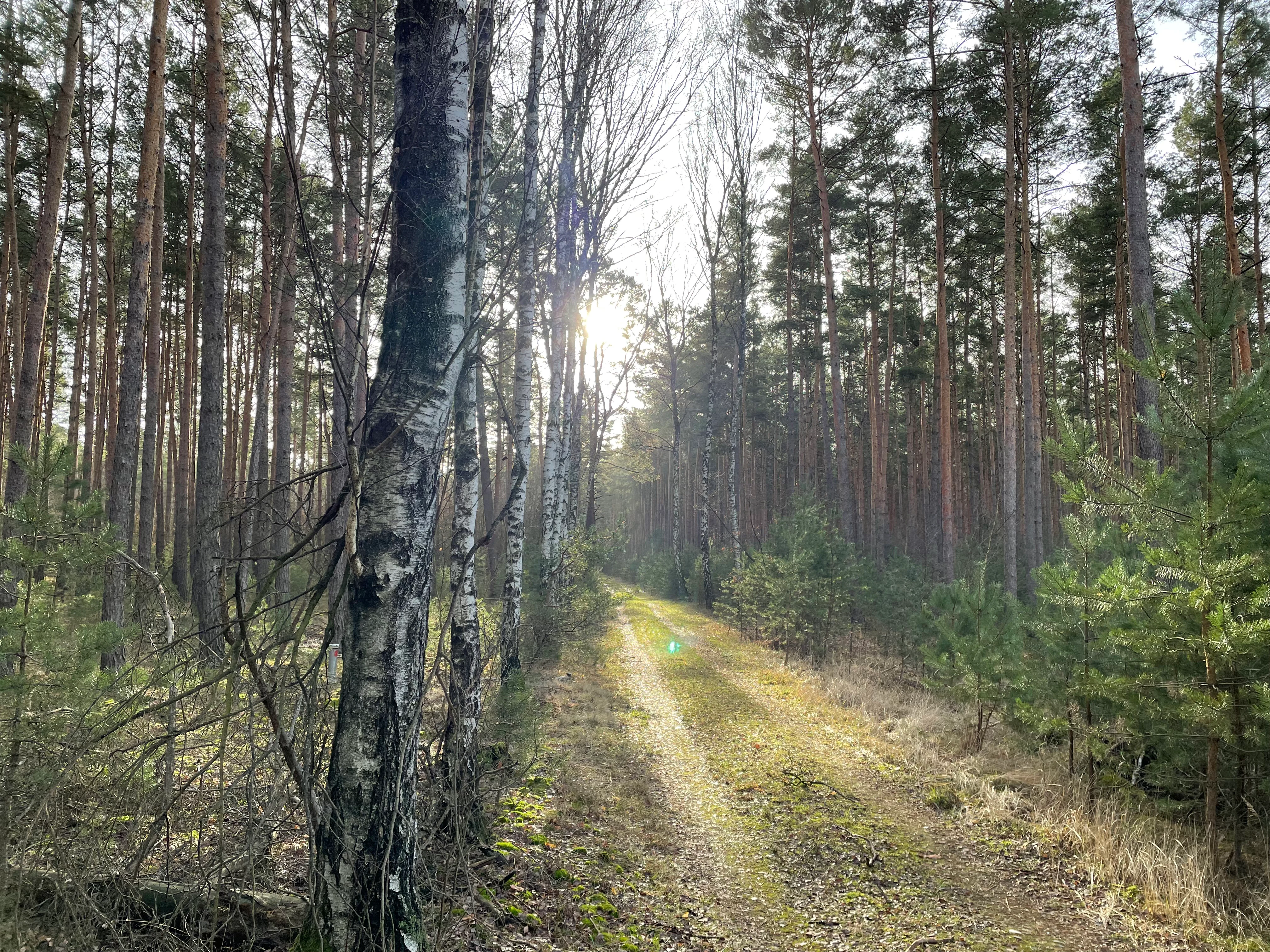
A dirt path leads through a dense forest of tall pine and birch trees, with sunlight filtering through the canopy.
A sunlit forest path winding through the Bärluch nature reserve.

Bärluch history and protected-area timeline

The area that is now Bärluch was placed under formal nature protection by decree on 18 September 2000, creating the Naturschutzgebiet Bärluch within the administrative framework of Brandenburg. It was assigned the official designation number 1584 and registered internationally in the World Database on Protected Areas under WDPA-ID 318165, aligning it with global standards for protected-area documentation.

An amending decree was issued on 13 December 2017, refining the original protection rules to adjust to evolving conservation needs. Over time, Bärluch has also become integrated into the broader landscape strategy of the Naturpark Nuthe-Nieplitz, which links it administratively and ecologically to neighboring reserves such as Rauhes Luch. The relatively recent legal designation reflects not a lack of ecological value, but rather the consolidation of habitat protection that had previously depended on more general landscape practices.

Bärluch landscape and geographic character

The landscape of Bärluch is defined by shallow, bowl-shaped depressions set within a gently undulating sand-dominated terrain typical of the Brandenburg glacial lowlands. These basins, formed in the aftermath of the last ice age, have gradually accumulated organic material to produce lowland fens and small bog pools. The result is a terrain where the eye moves constantly between higher, drier forest stands and lower, open, water-influenced clearings.

The reserve's eastern boundary runs along the Nuthe, a lowland river that contributes to the hydrology of the area and helps sustain the wet conditions in the inland basins. To the southeast, the landscape transitions into the adjacent Rauhes Luch reserve, while the surrounding region as a whole forms part of the Luckenwalder Heide natural area. Roads and nearby settlements, including Hennickendorf to the west and Märtensmühle near the eastern edge, frame the reserve without penetrating its interior, leaving a relatively intact core of wetland and forest.

Bärluch ecosystems, habitats, and plant life

Ecologically, Bärluch is a textbook example of a small lowland wetland complex. Its vegetation is structured around three main components: mixed oak forests on the drier upper ground, alder and birch swamp woodlands along the margins of the depressions, and wet meadows interspersed with lowland fens and bog lakes in the lowest basins. This layering gives the reserve both habitat diversity and strong ecological connectivity, as species can move between forest, edge, meadow, and open fen without crossing large unsuitable areas.

The fen and bog systems are the defining element of the reserve's ecology. Their post-glacial formation produced soils that are consistently moist and rich in organic material, supporting plant communities adapted to acidic, nutrient-limited conditions. These habitats, increasingly fragmented elsewhere in central Europe, are among the most important elements Bärluch seeks to preserve.

Bärluch wildlife and species highlights

Bärluch supports a breeding bird community of particular conservation interest, including species that are rare, declining, or sensitive to disturbance. The combination of swamp forest, open fen, and wet meadow makes the reserve attractive to water-associated and structurally diverse-habitat bird species that struggle to find suitable breeding grounds in more intensively used lowland landscapes.

Beyond birds, the reserve is significant for its amphibians and reptiles, several of which are considered threatened. The presence of standing water in bog pools and the integrity of the surrounding terrestrial habitats allow species dependent on both aquatic breeding sites and intact land cover to persist. The reserve's butterfly fauna is also notable, with species tied closely to wetland habitats and to the transitional edges where forest meets open fen. Together, these faunal groups illustrate the value of Bärluch as a site where multiple moisture-dependent groups can be supported simultaneously.

Bärluch conservation status and protection priorities

Bärluch is formally designated as a Naturschutzgebiet, Germany's strictest category of area-based nature protection, and it has been incorporated into the international World Database on Protected Areas. The reserve's overarching conservation objective is the preservation of its wetland-mosaic habitats and the species assemblages they support, particularly the breeding birds, amphibians, reptiles, and butterflies associated with wet conditions and forest edges.

The site's importance is amplified by its position within the wider Naturpark Nuthe-Nieplitz, which links Bärluch to a larger landscape-scale conservation framework. By maintaining the hydrology of small basins, preserving swamp woodland transitions, and protecting undisturbed open fen, Bärluch contributes to the survival of habitat types that have become heavily reduced elsewhere in central European lowlands. The amended protection order of 2017 reflects ongoing adaptive management to ensure these values are maintained against changing pressures.

Top sights and standout views in Bärluch

The most distinctive features of Bärluch are its post-glacial fens, its swamp forests of alder and birch, and the surrounding mixed oak woodlands that together form a finely balanced ecological mosaic. Its breeding bird fauna, including rare and disturbance-sensitive species, is among the reserve's strongest identity markers.

Close connectivity to the Nuthe river and to the neighboring Rauhes Luch reserve extends the reserve's ecological reach, while its inclusion in the Naturpark Nuthe-Nieplitz ties it into a wider southern Brandenburg conservation landscape.

Monthly climate preview

Long-term temperature and precipitation records across twelve months

Bärluch Climate Normals and Monthly Weather Statistics

Representative coordinate records show measured annual temperature ranges and precipitation rates across twelve consecutive monthly intervals. Examining the full climate profile provides deeper insight into long-term environmental patterns recorded at this location.
Annual mean10 °C
-1 °C20 °C
Jan-1°
Feb
Mar
Apr
May14°
Jun18°
Jul20°
Aug20°
Sep15°
Oct
Nov
Dec
Warmest month
July

20.3 °C

Coolest month
January

-0.7 °C

Wettest month
July

2.4 mm/day

Driest month
April

1.1 mm/day

Park location guide

Geography guide, regional context, and park location map for Bärluch

Bärluch park geography, regions, and map view in Germany

Understand where Bärluch sits in Germany through a broader geographic reading of the surrounding landscape, nearby location context, and its mapped position within the national park landscape.

How Bärluch fits into Germany

Germany is a federal republic in Western and Central Europe with a population of over 83 million across sixteen constituent states. It is Europe's largest economy by nominal GDP and a major global exporter and importer. The capital is Berlin, and the country borders Denmark, Poland, Czech Republic, Austria, Switzerland, France, Luxembourg, Belgium, and the Netherlands.

Wider geography shaping Bärluch in Germany

Germany is located in Western and Central Europe, spanning 357,022 km². It borders Denmark to the north, Poland and the Czech Republic to the east, Austria and Switzerland to the south, and France, Luxembourg, Belgium, and the Netherlands to the west. The country has coastlines on the Baltic Sea and North Sea to the north, with the Alps located in the southern region.

Map view of Bärluch

Use this park location map to pinpoint Bärluch in Germany, understand its exact geographic position, and read its mapped placement within the surrounding landscape more clearly.

Pigeon | © OpenStreetMap contributors

Location context for Bärluch

Rhineland-Palatinate

Explore photographic records of post-glacial fens, swamp forests, and wetland terrain.

Bärluch Photos and Landscape Scenery: Visualizing Protected Habitats

Visual documentation reveals the intricate post-glacial depressions, lowland fens, and mixed oak forests that define the protected environment of Bärluch. Examining these authentic protected-area views helps researchers and naturalists understand the nuanced terrain, habitat mosaics, and ecological structure of the reserve.

A dirt path leads through a dense forest of tall pine and birch trees, with sunlight filtering through the canopy.

Park atlas

Discover related lowland reserves and connected wetland conservation landscapes

Explore Protected Areas and Parks Near Bärluch in Brandenburg

Compare Bärluch with neighboring protected areas across the southern Brandenburg lowlands. Review adjacent post-glacial fens and woodland habitats to trace regional conservation networks.
A panoramic watercolor illustration showing a meadow with green grasses, pink and purple wildflowers, shrubs, a misty water body, rolling green hills in the background, and a bird flying in a pale yellow sky
Protected landscapeBrandenburg
About 5.7 km away#1 closest

West

Naturpark Nuthe-Nieplitz: Geographic Overview of a Brandenburg Protected Landscape

Glacial river valleys and rewilded pine forest terrain

Naturpark Nuthe-Nieplitz represents a significant protected area in Brandenburg, Germany, characterized by its interconnected river lowlands and glacial features. The terrain features a rich mix of reed-fringed lakes, alder woodlands, and former military grounds currently undergoing ecological restoration. This overview traces the boundaries and landscape character of the park, providing essential context for its role in regional conservation.

Area
623.23 km²
Established
1999
Relief
Lowland
Climate
Temperate
A soft watercolor illustration of a gentle river winding through green meadows and low hills under a hazy, warm sky.
Nature reserveBrandenburg
About 5.7 km away#2 closest

West

Europäisches Vogelschutzgebiet Nuthe-Nieplitz-Niederung Protected Area in Brandenburg

Glacial lake and river floodplain landscape context

This significant nature reserve forms a major ecological hub south of Berlin, characterized by its interplay of river floodplains, shallow glacial lakes, and open meadows. It is a critical site for breeding and migratory birds, offering a unique look at the hydrological systems and lowland geography that define the rural character of Brandenburg.

Area
61.44 km²
Established
2007
Relief
Lowland
Climate
Temperate
A soft watercolor painting of a wetland landscape with rolling hills in the background, clusters of trees, and marshy foreground vegetation.
Nature reserveBrandenburg
About 13 km away#3 closest

Southeast

Stärtchen und Freibusch Nature Reserve: Protected Forest and Glacial Valley Geography

A critical habitat node within the Baruth glacial valley of Brandenburg

Stärtchen und Freibusch is a specialized nature reserve in Brandenburg that preserves a near-natural woodland mosaic. The area features a dense concentration of old-growth and deadwood habitats, fen communities, and glacial dune terrain. As a protected area, it provides essential shelter for rare flora, saproxylic beetles, and diverse avian species, contributing to the connectivity of forest corridors throughout the Teltow-Fläming district.

Area
1.787 km²
Established
2002
IUCN
IV
Watercolor painting of a peaceful wetland scene with cattails in the foreground, calm reflective water, a dense tree line on the right, and soft, rolling hills in the background.
Protected landscapeBrandenburg
About 17 km away#4 closest

North

Pechpfuhl Protected Landscape: Glacial Terrain and Wetland Ecosystems in Brandenburg

A study of meltwater channels and post-glacial bog development

Pechpfuhl preserves a compact chain of wetlands created by subglacial erosion twenty thousand years ago. The landscape exhibits a transition from sandy pine-dominated dunes to a water-rich basin of alder swamps and floating bogs. As an established protected landscape, it provides critical insight into the hydrological and geological evolution of the Teltow plateau, serving as a distinct refuge for diverse bog-specific flora and fauna within the Brandenburg district.

Established
1958
Relief
Lowland
Climate
Temperate
Access
Easy access
A watercolor painting showing a horizontal landscape of green trees and reflected water against a light, misty background.
Nature reserveBrandenburg
About 18 km away#5 closest

Southeast

Schöbendorfer Busch Nature Reserve: Mapped Protected Geography in Brandenburg

Lowland deciduous forest and glacial valley landscape.

Schöbendorfer Busch provides a window into the natural heritage of the Baruther Urstromtal. This nature reserve protects over 800 hectares of forest and agricultural mosaic, serving as a primary habitat for rare saproxylic beetles and bats. Its terrain, defined by glacial meltwater deposits and wet alder swamp environments, offers a distinctive example of Brandenburg forest conservation.

Area
8.31 km²
Established
1978
IUCN
IV
A soft watercolor illustration showing rolling green hills, a small stream winding through the foreground, and distant purple-toned peaks against a white background.
Nature reserveBrandenburg
About 25 km away#6 closest

Northwest

Glindower Alpen: Protected Nature Reserve and Clay Mining Geography in Brandenburg

A striking post-industrial landscape and nature reserve

Glindower Alpen is a 120-hectare nature reserve near Werder, Germany, characterized by an atypical terrain of deep ravines and ridges resulting from historical clay mining. This protected area stands out as an island of mixed deciduous forests and dry grasslands amidst the broader flat geography of the Brandenburg region.

Area
1.19 km²
Established
1995
Relief
Upland
Climate
Temperate
A watercolor painting showing a soft, stylized landscape with open fields, a line of green trees, and distant hills under a light sky.
Protected landscapeBrandenburg
About 26 km away#7 closest

Northeast

Landschaftsschutzgebiet Diedersdorfer Heide und Großbeerener Graben Geography and Map Overview

A critical protected area in Brandenburg's peri-urban landscape mosaic.

Analyze the complex topography of Landschaftsschutzgebiet Diedersdorfer Heide und Großbeerener Graben, a large-scale protected zone south of Berlin. This atlas record provides detailed insight into the area's pine-dominated forest structure, wetland meadows, and the historic hydrological systems that define its contemporary habitat patterns and ecological reach.

Area
55 km²
Established
1998
Relief
Lowland
Scope
Terrestrial
Watercolor painting of a green wetland area with soft, blurred rolling hills in the background.
Nature reserveBerlin
About 27 km away#8 closest

North

Großes Fenn Nature Reserve: Protected Peatland and Kettle Bog Geography in Berlin

A study of post-glacial landforms and mire environments.

Großes Fenn represents a rare urban kettle bog formed during the last glacial period, now protected within the Berlin region. This reserve showcases the historical peat-forming processes and the fragile ecological balance of small depressions in the Düppeler Forest, offering a compact site for understanding glacial landscape legacies.

Area
0.064 km²
Established
1986
IUCN
IV

Common questions about visiting, size, designation, and location context for Bärluch

Bärluch FAQs for park facts, access, geography, and protected area context

Find quick answers about Bärluch, including protected-area facts, park geography, trail and visitor context, and how the park fits into its surrounding country and regional landscape.
MoriAtlas Explorer

Continue Your Protected Areas Search Across the Global Atlas

Deepen your exploration by continuing the structured search for national parks and protected areas worldwide. Utilize the comprehensive filtering capabilities to compare different conservation landscapes and refine your understanding of global park geography. Discover more about the distribution and characteristics of protected natural areas.

Global natural geography