

Mori Atlas logo
National parkBasse Casamance National Park

Explore the mapped boundaries and geographic context of this national park in Ziguinchor Region.

Basse Casamance National Park: Protected Landscape and Regional Geography Atlas

(Parc National de la Basse Casamance)

Basse Casamance National Park stands as a key protected area within Senegal, located in the Ziguinchor Region. This national park offers a unique focal point for understanding regional geography and conservation landscapes. Users can explore the mapped extent of Basse Casamance National Park, gaining insights into its boundaries and its position within the surrounding terrain, providing a detailed look at this specific protected land.

national parkGuinean forestWest Africaprotected areaSenegalforest conservation

Basse Casamance National Park

National park

Park overview

Structured park overview, official facts, and landscape profile for Basse Casamance National Park

Basse Casamance National Park park facts, protected area profile, and essential visitor context
Review the core facts for Basse Casamance National Park, including designation, size, terrain, visitor scale, habitats, and operating context in one park-focused overview.

About Basse Casamance National Park

Basse Casamance National Park occupies a distinctive position within Senegal's national park system as the country's protected area representing the Guinean forest ecosystem type in the Casamance region. Located in the southern portion of the country near the border with Guinea-Bissau, the park sits within the Ziguinchor Region, one of Senegal's fourteen administrative regions. The landscape combines two primary biotope types, the Guinean forests and savannah woodlands, creating a mosaic of habitats that supports both forest-dependent and savannah-adapted species. The park's establishment in 1970 reflected Senegal's commitment to preserving representative samples of its diverse ecological zones, with the Guinean forest ecosystem being particularly significant given its restricted distribution across West Africa. The park is administered under the authority of Senegal's Ministry of Environment and Sustainable Development, though operational access has been severely limited by the Casamance conflict that has affected the region for decades.

Quick facts and research context for Basse Casamance National Park

Basse Casamance National Park is located in southern Senegal, approximately 20 kilometers from Cap Skirring Airport near the town of Oussouye. The protected area spans 50 square kilometers and was created in 1970, making it one of Senegal's older national parks. The park features Guinean forest ecosystems combined with savannah woodland biotopes, supporting 200 bird species and 50 mammal species. Notable mammal species present include African forest buffalo, African leopard, Campbell's mona monkey, Prince Demidoff's bushbaby, and western red colobus.

Park context

Deeper park guide and search-rich context for Basse Casamance National Park

Basse Casamance National Park history, landscape, wildlife, and travel context
Explore Basse Casamance National Park through its history, landscape character, ecosystems, wildlife, conservation priorities, cultural context, and seasonal travel timing in a structured park guide built for atlas discovery and search intent.

Why Basse Casamance National Park stands out

Basse Casamance National Park is best known for its representation of Guinean forest ecosystems within Senegal's protected area network. The park shelters a remarkable diversity of wildlife within its relatively compact 50-square-kilometer boundary, including significant populations of primates such as western red colobus and Campbell's mona monkey. Its designation as a Category II national park reflects its importance in preserving West Africa's Guinean forest biodiversity corridor, which is recognized as a critical ecological region across multiple West African nations.

Basse Casamance National Park history and protected-area timeline

Basse Casamance National Park was created in 1970 as part of Senegal's developing national park system during a period when the country was expanding its network of protected areas. The park was established to protect the Guinean forest ecosystem, which extends from Senegal southward through Guinea, Sierra Leone, Liberia, Ivory Coast, and into Ghana. This ecosystem type is characterized by dense tropical woodland and supports numerous endemic species, making its representation in protected areas strategically important for regional biodiversity conservation. The park was officially designated under IUCN Category II, reflecting its primary purpose of protecting natural ecosystems while allowing for limited sustainable use where appropriate.

Basse Casamance National Park landscape and geographic character

The physical landscape of Basse Casamance National Park consists primarily of Guinean forest habitats characterized by dense tree cover and undergrowth, interspersed with savannah woodland areas that create a heterogeneous terrain. The region's topography within the Casamance zone generally features gentle rolling terrain with altitude variations typical of the coastal plain extending inland from the Atlantic Ocean. The combination of forest and savanna biotopes creates a landscape of considerable ecological interest, as these transitional zones often support unique species assemblages that depend on the mosaic of habitats. The park's relatively compact size of 50 square kilometers encapsulates representative examples of these habitat types, allowing for the protection of ecological processes within a bounded area.

Basse Casamance National Park ecosystems, habitats, and plant life

The ecological character of Basse Casamance National Park is defined by its position within the Guinean Forests of West Africa biodiversity hotspot, one of the most significant forest ecosystems on the African continent. This ecoregion is recognized for its exceptional endemism and species diversity, despite ongoing habitat loss and fragmentation across its range. The park's dual biotope composition of forest and savannah woodland creates a diversity of ecological niches that supports both specialized forest species and more generalist savannah-adapted organisms. This habitat diversity contributes to the park's significance as a conservation area within the broader West African forest corridor that spans multiple countries and represents a critical refuge for numerous species.

Basse Casamance National Park wildlife and species highlights

Basse Casamance National Park supports a notable collection of wildlife, with documented populations of 200 bird species and 50 mammal species within its boundaries. The mammal fauna includes several species of particular conservation interest, including the African forest buffalo and African leopard, both of which are significant predators and herbivores within the forest ecosystem. Primate species are well represented, with Campbell's mona monkey, Prince Demidoff's bushbaby, and western red colobus all present in the park's forest habitats. The western red colobus is particularly notable as a forest-dwelling primate that depends on intact tree cover and is considered an indicator species for forest ecosystem health. The bird species diversity reflects the park's mix of forest and savannah habitats, which together support a wide range of avifauna adapted to different ecological zones.

Basse Casamance National Park conservation status and protection priorities

Basse Casamance National Park represents an important component of Senegal's conservation infrastructure, serving as a protected area for the Guinean forest ecosystem type within the country's borders. The park's IUCN Category II designation reflects its primary function as a national park focused on ecosystem protection rather than multi-use conservation. The Guinean Forests of West Africa are recognized as a critical biodiversity hotspot, and protected areas like Basse Casamance play a vital role in maintaining ecological corridors and protecting species that depend on these forest habitats. Despite challenges including regional conflict and access restrictions, the park maintains its protected status and continues to serve as a designated conservation area within Senegal's national park network.

Basse Casamance National Park cultural meaning and human context

The park is situated within the Casamance region of Senegal, an area that has experienced ongoing conflict between separatist movements and the Senegalese government since the early 1980s. This Casamance conflict has had significant implications for the region, including limiting access to Basse Casamance National Park and rendering the area unsafe for tourism and regular park operations. The conflict has historical roots in regional autonomy concerns and economic marginalization perceptions, and its persistence has affected the lives of local communities in the Ziguinchor Region. The presence of landmines in some areas of the Casamance region has further complicated access to certain locations, including portions of what should be protected parkland.

Top sights and standout views in Basse Casamance National Park

The park's primary highlights include its representation of the Guinean forest ecosystem within Senegal, its significant primate populations including western red colobus and Campbell's mona monkey, its documented 200 bird species and 50 mammal species, and its status as one of Senegal's six national parks established in 1970. The combination of forest and savannah woodland habitats creates a diverse ecological landscape within a relatively compact protected area, supporting species adapted to both ecosystem types.

Best time to visit Basse Casamance National Park

Basse Casamance National Park is currently closed to visitors due to the Casamance conflict, and there is no established timeline for when access might be restored. The ongoing security situation in the region has prevented normal park operations for several years, and potential visitors should consult current travel advisories for Senegal's Casamance region before considering any travel to the area. When the park does reopen, the optimal visiting period would likely align with the dry season from November through May, which offers more comfortable conditions for wildlife viewing and outdoor activities in the region.
Park location guide

Geography guide, regional context, and park location map for Basse Casamance National Park

Basse Casamance National Park park geography, regions, and map view in Senegal
Understand where Basse Casamance National Park sits in Senegal through a broader geographic reading of the surrounding landscape, nearby location context, and its mapped position within the national park landscape.

How Basse Casamance National Park fits into Senegal

Senegal is a West African country along the Atlantic coast, bordered by Mauritania, Mali, Guinea, and Guinea-Bissau. It nearly surrounds The Gambia and shares a maritime border with Cape Verde. The capital is Dakar.

Wider geography shaping Basse Casamance National Park in Senegal

Senegal is situated in West Africa along the Atlantic Ocean coast. It borders Mauritania to the north, Mali to the east, Guinea to the southeast, and Guinea-Bissau to the southwest. The country nearly surrounds The Gambia, a narrow strip along the Gambia River that separates the Casamance region from the rest of Senegal.

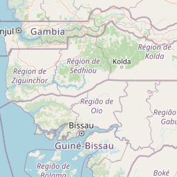
Map view of Basse Casamance National Park

Use this park location map to pinpoint Basse Casamance National Park in Senegal, understand its exact geographic position, and read its mapped placement within the surrounding landscape more clearly.

Pigeon | © OpenStreetMap contributors

Location context for Basse Casamance National Park

Ziguinchor Region
Park atlas

Compare contiguous protected landscapes and diverse ecosystems in the surrounding Casamance region and across West Africa.

Discover Nearby National Parks and Protected Areas in the Basse Casamance Region
Continue your geographic exploration beyond Basse Casamance National Park by browsing other national parks and protected areas that characterize the Guinean forest and savannah landscapes. Compare their distinct conservation features and regional spread to understand the interconnected protected area network across West Africa's diverse landscapes.
National parkGambia

Tanji Bird Reserve National Park: Coastal Wetlands and Avian Diversity in Gambia

Explore unique geography and protected landscape boundaries.

Tanji Bird Reserve National Park showcases a distinctive coastal landscape where the Atlantic Ocean meets lagoons, dry woodland, and dune scrub. This 612-hectare protected area in The Gambia is celebrated for its incredible birdlife, with nearly 300 species recorded, including significant Palearctic migrants and the nation's sole breeding seabird colonies on the Bijol Islands. The reserve offers a rich context for understanding West African protected areas, mapped terrain, and coastal ecosystem geography.

Area
6.12 km²
Established
1993
IUCN
II
Relief
Lowland
Nature reserveGambia

Abuko Nature Reserve: A Protected Nature Reserve in Gambia's Landscape

Explore its mapped boundaries and geographic context.

Abuko Nature Reserve is a protected natural area situated in Gambia, offering a distinct focus for understanding protected landscapes. This entry provides essential details for atlas-based discovery, highlighting the reserve's mapped boundaries and its role within the regional geography. Examine Abuko Nature Reserve to gain clarity on its protected status and its contribution to the mapped natural terrain of West Africa.

Area
1.07 km²
Established
1968
IUCN
IV
Relief
Lowland
National parkGambia

Tanbi Wetland Complex National Park: A Mapped Protected Area in The Gambia

Explore its protected boundaries and regional landscape.

Delve into the geographic identity of Tanbi Wetland Complex National Park, a designated protected area within The Gambia. This page provides essential atlas-level information, focusing on its mapped natural landscape and its role as a significant national park. Understand the park's protected status and its geographical context along the Gambia River, offering a clear entry point for conservation landscape discovery.

Area
45 km²
Established
2001
IUCN
II
Relief
Lowland
National parkGuinea-Bissau

Orango National Park: Protected Landscape and Geographic Atlas Explorer in Guinea-Bissau

Discover mapped park boundaries and regional natural terrain.

Delve into the protected-area identity of Orango National Park, a significant national park located in Guinea-Bissau. This page provides essential geographic context, mapping details, and landscape character for atlas-driven exploration. Understand how Orango National Park fits within the broader regional geography of West Africa, offering a focused view of protected lands for dedicated discovery.

Area
1,582 km²
Established
2000
IUCN
II
Relief
Lowland
National parkGambia

Niumi National Park: Gambia's Extensive Mangrove Forest and Coastal Wetland Protected Area

Explore the mapped boundaries and unique delta geography of this important national park.

Niumi National Park, situated in The Gambia, is a crucial protected coastal area celebrated for its vast Rhizophora mangrove forests and diverse wetland ecosystems. As a designated national park and Ramsar site, it serves as a critical habitat for numerous migratory bird species, particularly terns, and supports vulnerable marine life. Its landscape is characterized by tidal channels, brackish lagoons, and intertidal mudflats, creating a dynamic and ecologically significant protected zone that is a focal point for understanding West African coastal geography and conservation.

Area
49.4 km²
Established
1987
IUCN
II
Relief
Lowland
National parkGambia

Kiang West National Park: National Park Detail and Protected Landscape Geography

Explore mapped boundaries and regional context in The Gambia.

Kiang West National Park serves as a crucial point for understanding protected natural areas within The Gambia, West Africa. This national park's identity is rooted in its geographic setting along the Gambia River, offering a distinct landscape context and mapped territory. Users can explore its boundaries and place within the nation's conservation network, contributing to a structured understanding of regional geography and protected lands.

Area
115 km²
Established
1987
IUCN
II
Relief
Lowland
National parkSenegal

Saloum Delta National Park: Detailed Map Exploration of Senegal's Protected Landscape

Explore the mapped boundaries and regional terrain of this national park.

Saloum Delta National Park, a designated national park in Senegal, serves as a key entity for understanding protected landscapes in West Africa. This entry focuses on its geographic specificities, providing mapped context and details about its natural terrain. Users can explore the park's boundaries and regional landscape character, contributing to a richer atlas-based discovery of Senegal's conservation areas and natural geography.

Area
760 km²
Established
1976
Relief
Lowland
Climate
Tropical
Wildlife reserveGambia

Bao Bolong Wetland Reserve: West African Wildlife Reserve with Extensive Mangrove Ecosystems

Explore mapped terrain and crucial protected wetland boundaries.

Bao Bolong Wetland Reserve in Gambia is a significant protected area renowned for its ecological importance as a Ramsar wetland and Important Bird Area. This wildlife reserve features the tallest mangrove trees in the Senegambia region, transitioning through salt marshes to savanna, all centered around the Bao Bolong tributary's estuary. Its complex hydrological network and diverse habitats support 268 bird species and are crucial for the endangered West African manatee, offering a rich landscape for geographic and protected-area discovery.

Area
220 km²
Established
1996
IUCN
VI
Relief
Lowland

Common questions about visiting, size, designation, and location context for Basse Casamance National Park

Basse Casamance National Park FAQs for park facts, access, geography, and protected area context
Find quick answers about Basse Casamance National Park, including protected-area facts, park geography, trail and visitor context, and how the park fits into its surrounding country and regional landscape.
MoriAtlas Explorer

Continue Your Protected Areas Search Across the Global Atlas

Deepen your exploration by continuing the structured search for national parks and protected areas worldwide. Utilize the comprehensive filtering capabilities to compare different conservation landscapes and refine your understanding of global park geography. Discover more about the distribution and characteristics of protected natural areas.

Global natural geography
