

Mori Atlas logo
Protected landscapeBielańsko-Tyniecki Park Krajobrazowy

Examining the intersection of Vistula river corridors and limestone forest terrain in southern Poland

Bielańsko-Tyniecki Park Krajobrazowy: A Mapped Protected Landscape in Lesser Poland Voivodeship

The Bielańsko-Tyniecki Park Krajobrazowy preserves a unique mosaic of Jurassic limestone outcrops, river terraces, and deciduous forests along the upper Vistula valley. This protected landscape extends across the northwestern fringe of the Kraków-Częstochowa Upland, integrating natural karst features with centuries-old monastic heritage. The area functions as a critical green corridor, connecting diverse ecological zones from riparian meadows to upland slopes.

landscape parkVistula valleyJura Krakowsko-Częstochowskalimestone hillsrock formationsdeciduous forest

Bielańsko-Tyniecki Park Krajobrazowy

Protected landscape

Park overview

Structured park overview, official facts, and landscape profile for Bielańsko-Tyniecki Landscape Park

Bielańsko-Tyniecki Landscape Park park facts, protected area profile, and essential visitor context

Review the core facts for Bielańsko-Tyniecki Landscape Park, including designation, size, terrain, visitor scale, habitats, and operating context in one park-focused overview.

About Bielańsko-Tyniecki Landscape Park

Bielańsko-Tyniecki Landscape Park is one of the most accessible landscape parks in Poland, sitting directly on the western edge of Kraków. It was established in 1981 to protect a section of the upper Vistula valley and the adjacent limestone uplands between Kraków and Ściejowice. Today it forms part of the Complex of Landscape Parks of the Małopolskie Voivodeship, a network of protected areas that share administration and conservation strategy across the region.

The natural character of the park is defined by the contrast between two neighboring landscapes. To the north and west rise the foothills of the Kraków-Częstochowa Upland (Jura), with limestone and dolomite ridges, isolated rock cliffs, karst formations, caves, and a patchwork of deciduous forest. To the south the terrain drops toward the wide, flat Vistula valley, with oxbow lakes, floodplain meadows, riverine woods, and wet grassland communities. This juxtaposition of rocky upland and river lowland gives the park its unusually rich ecological profile within a relatively compact area.

Three forest complexes form the ecological backbone of the park. The Lasek Wolski, on the western outskirts of Kraków, is the largest urban-adjacent forest in the area and is closely associated with the Camaldolese monastery at Bielany. South of the Vistula, the forests around Tyniec and the woodlands to the west of Czernichów add extensive wooded terrain that buffers the river and connects the park to neighboring protected areas. The mix of beech, oak, hornbeam, linden, and small stands of yew and fir reflects the transitional character of the local climate, where western European broadleaf forests meet more continental influences.

Rocks and caves are a signature feature. The Bielańskie Skałki reserve protects a classic limestone rock group with thermophilic vegetation, while Panieńskie Skały is known for its picturesque cliffs and woodland setting. Skałczanka, although primarily a steppe-fauna reserve, also preserves dry grassland and xerothermic habitats on south-facing slopes. The Jaskinia Kryspinowska cave, which extends for several hundred meters, is a notable karst site within the park's protected natural monuments.

Beyond its natural value, the park is deeply layered with cultural heritage. The name itself reflects the two monasteries that define its geography: the Camaldolese house on Bielany (Kościół Wniebowzięcia Najświętszej Maryi Panny) and the Benedictine abbey at Tyniec (Opactwo Benedyktynów w Tyńcu), one of the oldest religious houses in Poland. Across the landscape are scattered chapels, manor houses, historic parks, avenues of ancient lime trees, and the Villa Decjusz estate with its Renaissance garden. Together with the natural reserves, these sites make the park a place where ecology, history, and spirituality meet within a short distance of central Kraków.

Quick facts and research context for Bielańsko-Tyniecki Landscape Park

Bielańsko-Tyniecki Landscape Park was created on 2 December 1981 by Resolution No. 65 of the National Council of the City of Kraków. It lies in the Małopolskie voivodeship, covering parts of Kraków together with the communes of Czernichów and Liszki, and it shares its name with two historic monasteries: the Camaldolese monastery on Bielany and the Benedictine abbey at Tyniec.

The park covers roughly 63.6 square kilometers and is surrounded by a protective buffer zone of about 97.7 square kilometers. Within its boundaries are four nature reserves (Bielańskie Skałki, Panieńskie Skały, Skałki Przegorzalskie, and Skołczanka), several Natura 2000 meadow and species sites, five ecological use areas, and around 63 individual natural monuments. Geographically it spans the Pomost Krakowski mesoregion and the Obniżenie Cholerzyńskie depression, transitioning between upland hills and the Vistula valley.

Protection and recognition

Examine documented terrestrial protection records and international recognition data for Bielańsko-Tyniecki Park Krajobrazowy.

Bielańsko-Tyniecki Park Krajobrazowy Protection Status and Designated Area Scope

Bielańsko-Tyniecki Park Krajobrazowy maintains structured terrestrial protection status details and verified administrative records within the regional conservation database. Conservation researchers review documented management parameters and official designation facts associated with this protected area landscape.

Protection details

Protection scope
Terrestrial
Transboundary protection
No
Buffer area
97.66 km²
Park context

Deeper park guide and search-rich context for Bielańsko-Tyniecki Landscape Park

Bielańsko-Tyniecki Landscape Park history, landscape, wildlife, and travel context

Explore Bielańsko-Tyniecki Landscape Park through its history, landscape character, ecosystems, wildlife, conservation priorities, cultural context, and seasonal travel timing in a structured park guide built for atlas discovery and search intent.

Why Bielańsko-Tyniecki Landscape Park stands out

The park is best known for protecting a stretch of the Vistula valley west of Kraków where Jurassic limestone hills, beech and oak forests, rocky outcrops, and river meadows come together in a single accessible landscape. Its most distinctive natural features are the limestone rock groups called Skałki: Bielańskie Skałki, Panieńskie Skały, and Skałki Przegorzalskie, together with the karst cave Jaskinia Kryspinowska. Equally defining is the cultural layer that gives the park its name. The Camaldolese hermitage on Bielany, the Benedictine abbey at Tyniec, the Villa Decjusz estate, and a network of historic manor parks, wayside chapels, and tree avenues have shaped the landscape for centuries. The combination of upland forest, river valley, monastic heritage, and proximity to Kraków makes the park a rare example of a large, ecologically diverse protected area immediately adjacent to a major Polish city.
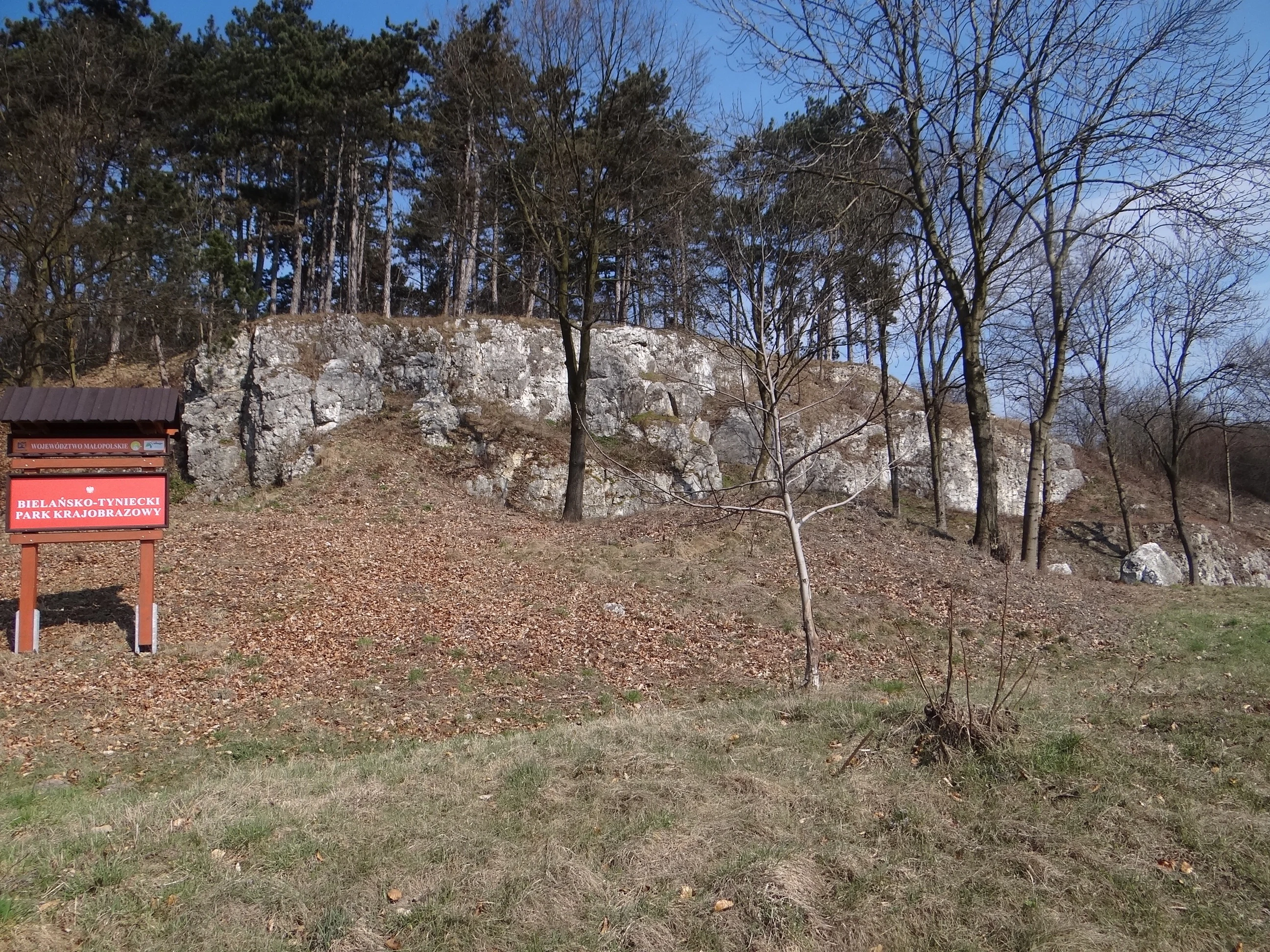
Celiny forest tract
A view of the Celiny forest tract located near the DK5 road

Bielańsko-Tyniecki Landscape Park history and protected-area timeline

The landscape protected today as Bielańsko-Tyniecki Park Krajobrazowy has been shaped by human activity for centuries, but its formal protection is relatively recent. The park was established on 2 December 1981 through Resolution No. 65 of the National Council of the City of Kraków (Rada Narodowa Miasta Krakowa), at a time when Poland was actively expanding its network of landscape parks to safeguard valued rural and peri-urban environments around growing cities.

For much of its post-war history the area was administered as part of the Complex of Jurassic Landscape Parks (Zespół Jurajskich Parków Krajobrazowych), a regional grouping that coordinated management across several protected areas on the Kraków-Częstochowa Upland. After administrative reforms, the park was incorporated into the broader Complex of Landscape Parks of the Małopolskie Voivodeship (Zespół Parków Krajobrazowych Województwa Małopolskiego), which currently oversees its management, conservation programs, and public information.

Earlier landscape history runs much deeper. The Camaldolese monastery on Bielany was established in the early modern era and gave rise to a long tradition of religious forest management around the Lasek Wolski. The Benedictine abbey at Tyniec is one of the oldest continuously operating monasteries in Poland and has shaped land use in its part of the Vistula valley for more than a millennium. Villa Decjusz, a Renaissance noble residence, and the rural manor complexes of Czernichów, Ściejowice, Chełm, and Koło Tynieckie contributed avenues, orchards, and ornamental parks that later became registered historic monuments. Some of these older landscape elements, including ancient lime avenues and historic park layouts, are now formally recognized as natural monuments within the park.

A new layer of conservation history was added in the early twenty-first century with the designation of several Natura 2000 sites that overlap with or border the park, particularly the Dębnicko-Tyniecki meadow area, the Skawiński meadow area, and the Rudniańskie Modraszki-Kajasówka butterfly site. Together with the older reserves, these designations reflect an evolving understanding of the park as a mosaic of forest, rock, steppe, river, and meadow habitats deserving coordinated European-level protection.

Bielańsko-Tyniecki Landscape Park landscape and geographic character

The landscape of Bielańsko-Tyniecki Landscape Park is built around two contrasting yet interlocking landforms: a section of the Vistula valley running roughly east to west, and the limestone foothills of the Kraków Upland rising to its north and south. In the mesoregional classification the park lies mainly within the Pomost Krakowski (Kraków Bridge) and partly within the Obniżenie Cholerzyńskie (Cholerzyn Depression), a transitional zone where upland ridges give way to the broad floodplain of the upper Vistula.

In the upland belt the terrain is shaped by Jurassic limestone and dolomite. Hills and ridges alternate with shallow valleys, leaving prominent rocky outcrops that have resisted erosion for millions of years. The Bielańskie Skałki, Panieńskie Skały, and Skałki Przegorzalskie are the most photographed examples, but smaller rock groups appear throughout the wooded slopes. Karst processes are active across this terrain: sinkholes, fissures, and caves, including the 255-meter Jaskinia Kryspinowska, document a long history of underground water shaping the bedrock beneath the forest.

The Vistula valley forms the park's other main physiographic element. Wide river terraces, old meanders, oxbow lakes, and low islands create a flat, open counterpoint to the hills. Floodplain meadows, marshy depressions, and riverine willow and alder stands line the watercourse, while slightly higher terraces support dry grassland communities and patches of xerothermic vegetation on south-facing slopes. These meadows, especially around Dębnik, Tyniec, and downstream toward the Skawina area, are an essential part of the Vistula ecological corridor and a key reason the park overlaps with several Natura 2000 designations.

Between the two extremes lies a transitional zone of gentle slopes, mixed forest, small streams, and scattered settlements. Limestone valleys cut by brooks create moist, shaded habitats that contrast with the dry, sun-exposed rock faces only a short distance away. This compressed geography, where upland cliffs overlook river meadows and monasteries sit above forests, gives the park a striking scenic variety despite its modest size.

Bielańsko-Tyniecki Landscape Park ecosystems, habitats, and plant life

The park's ecological identity is shaped by the meeting of three big habitat worlds: limestone upland forest, xerothermic rock and steppe, and the Vistula floodplain. Each contributes both plant communities and animal groups that depend on specific microclimates and soils.

The forested uplands are dominated by deciduous woodland typical of the Kraków-Częstochowa ridge. Mature and semi-natural beech stands mix with oak-hornbeam forests, lime, maple, and occasional yew and fir, particularly in protected areas such as Bielańskie Skałki, where the tree layer is left largely untouched. The forest understory reflects the limestone substrate, with species adapted to calcareous soils and the shade of closed canopy. Rock outcrops and the surrounding rock-steppe patches harbor drought-adapted grasses, herbs, and shrubs, forming some of the most botanically distinctive communities in the park.

The Vistula floodplain, by contrast, is defined by open and semi-open habitats. Extensive meadows, many of them traditionally managed, support a rich flora of grasses and wildflowers and provide habitat for meadow birds, pollinators, and small mammals. Willow and alder floodplain forests line the river and older channels, while ponds and abandoned meanders create wetland conditions favored by amphibians and waterbirds. Natura 2000 sites such as Dębnicko-Tyniecki obszar łąkowy and Skawiński obszar łąkowy capture much of this meadow and wetland character.

Karst phenomena add a fourth dimension. Caves, rock fissures, and shaded limestone cliffs support specialized invertebrates, bats, and a network of specialized mosses and ferns. The combination of dry rock, damp valleys, caves, forests, meadows, and the river itself produces an unusually high habitat diversity for a park of this size, and helps explain why it is also a stronghold for protected butterfly species and steppe fauna.

Bielańsko-Tyniecki Landscape Park wildlife and species highlights

Although the park is best known for its scenery and monastic heritage, it supports a rich and varied fauna shaped by the combination of forest, rock, river, and meadow. The Skołczanka reserve protects steppe-type fauna communities, including insects and other invertebrates associated with xerothermic grasslands on southern slopes, a relatively unusual habitat type for this part of Poland.

The forest reserves, particularly Bielańskie Skałki and the broader Lasek Wolski, host typical central European woodland fauna. Red deer, roe deer, and wild boar are common in larger forest tracts, while smaller mammals including foxes, martens, squirrels, and hedgehogs inhabit more diverse edges and clearings. Birds of mature deciduous forest, such as woodpeckers, nuthatches, and forest owls, are well represented in the quieter upland areas.

The Vistula valley and its floodplain meadows are particularly important for meadow-nesting birds, waterfowl, and waders. Ponds, oxbows, and wet depressions support amphibians including frogs and newts, while fish species typical of the upper Vistula populate the river and its connected side channels. Butterflies and other pollinators thrive in both dry rock and meadow habitats, and the Rudniańskie Modraszki-Kajasówka Natura 2000 site partly overlapping the park's buffer zone highlights the regional importance of the area for protected butterfly species.

Caves and rock formations such as Jaskinia Kryspinowska and the various Skałki groups host bat colonies and a specialist invertebrate fauna adapted to cool, shaded, calcareous environments. Taken together, the wildlife value of the park lies less in charismatic large species than in the breadth and interconnectedness of its forest, meadow, rock, and riverine fauna.

Bielańsko-Tyniecki Landscape Park conservation status and protection priorities

From a conservation perspective, Bielańsko-Tyniecki Landscape Park functions as a multi-layered protection hub where landscape-level conservation, strict reserves, ecological use areas, Natura 2000 designations, and individual natural monuments reinforce one another. The park framework provides a broad umbrella of rules and land-use planning across roughly 64 square kilometers, while the underlying reserves and Natura 2000 sites apply stricter habitat-specific protections to the most sensitive features.

The four nature reserves cover complementary ecological priorities. Bielańskie Skałki protects a strict forest reserve on limestone, preserving mature woodland with minimal human intervention. Panieńskie Skały is a partial landscape reserve focused on protecting scenic rock formations and their vegetation. Skałki Przegorzalskie is a floristic reserve targeting rare plant communities, while Skołczanka is a faunistic (steppe) reserve designed to safeguard xerothermic fauna communities that are otherwise rare in the region. Together they protect forest, rock, plant, and steppe habitats within a short radius.

The inclusion of Dębnicko-Tyniecki obszar łąkowy, Skawiński obszar łąkowy, and Rudniańskie Modraszki-Kajasówka within or near the park connects it to the European Natura 2000 network, with a particular emphasis on meadow ecosystems and protected butterfly habitats. Five ecological use areas, including Uroczysko Celiny and Zakrzówek, add further local protection for specific habitats, while about 63 natural monuments protect individual trees, avenues, caves, springs, and historic parks such as Park Decjusza or the avenue of small-leaved limes beside the Tyniec Abbey.

The park's location on the edge of a major urban conurbation gives it additional conservation significance. As Kraków has expanded, the protected area has increasingly served as a green buffer, ecological corridor, and recreational landscape, helping to maintain habitat connectivity between the Jura uplands and the Vistula valley and to safeguard a mosaic of habitats under significant development pressure.

Bielańsko-Tyniecki Landscape Park cultural meaning and human context

The cultural identity of Bielańsko-Tyniecki Landscape Park is unusually rich for a peri-urban protected area, and it is woven directly into the landscape rather than being confined to a few historical buildings. The name itself commemorates two of the oldest religious communities in the region: the Camaldolese monastery (Klasztor Ojców Kamedułów) on Bielany, founded in the early modern period and traditionally associated with the Lasek Wolski, and the Benedictine abbey at Tyniec (Opactwo Benedyktynów w Tyńcu), one of the oldest monasteries in Poland, whose presence shaped land use in the western Vistula valley for more than a thousand years.

Smaller sacred and rural heritage sites add further depth. The Chapel of the Rosary in Czernichów (Kaplica Różańcowa), the chapel of Our Lady of the Snow in Bodzów, and the parish churches scattered through the park's villages represent a continuity of spiritual landscape that parallels the natural reserves. Many of these sites are surrounded by old trees, avenues, or small gardens that themselves are protected as natural monuments, blurring the boundary between cultural heritage and ecological heritage.

Secular heritage is equally significant. The Renaissance Villa Decjusz (Willa Decjusza) with its historic park, together with manor estates in Chełm, Koło Tynieckie, Ściejowice, and Czernichów, contributes a network of historical parks, avenues of ancient lime and other trees, and ornamental landscapes that are now formally recognized as monuments of nature as well as of culture. The presence of Przegorzały, Bielany, Tyniec, and their surrounding villages within a single protected landscape area gives the park a tangible human dimension that complements its ecological function.

Top sights and standout views in Bielańsko-Tyniecki Landscape Park

Bielańsko-Tyniecki Landscape Park concentrates a striking range of natural and cultural assets within a small area on the edge of Kraków. Its scenic highlights include the dramatic limestone cliffs of Bielańskie Skałki and Panieńskie Skały, the panoramic skylines of the Vistula valley seen from Skałki Przegorzalskie, and the broad floodplain meadows of Dębnik and Tyniec that contrast sharply with the wooded uplands.

Ecologically, the park is notable for combining four reserve types in a single landscape: the strict forest reserve of Bielańskie Skałki, the landscape reserve of Panieńskie Skały, the floristic reserve at Skałki Przegorzalskie, and the steppe fauna reserve at Skołczanka. The presence of Jaskinia Kryspinowska and other karst features, alongside 63 natural monuments, makes it a densely protected area despite its proximity to a major Polish city.

Culturally, the park offers visitors the historic Camaldolese monastery at Bielany, the ancient Benedictine abbey at Tyniec, the Renaissance Villa Decjusz estate, and a network of chapels, manor parks, and avenues of old lime trees that together form one of the most heritage-rich landscape parks in Małopolska.

Best time to visit Bielańsko-Tyniecki Landscape Park

The park's scenery changes meaningfully with the seasons, and different times of year reveal different aspects of its character. Late spring and early summer are especially rich for visitors interested in wildflowers and meadow biodiversity: the Vistula floodplain meadows around Dębnik and Tyniec come into bloom, woodland understory species flourish in the deciduous forests, and bird activity is high. The contrast between fresh green upland forest and flowering river meadows is at its most striking in this period.

Late summer and early autumn offer a different appeal. The deciduous forests, particularly around Lasek Wolski and the Tyniec woodlands, take on warm autumn colors, while the rocky outcrops and the open meadows remain accessible on pleasant dry days. Autumn is also a good season for observing fungi in the older forest reserves and for enjoying broader landscape views from the Skałki rock groups and from higher ground above the Vistula.

Winter brings quieter conditions, with snow-covered limestone cliffs, frosted river meadows, and clear views across the bare Vistula valley. Although some smaller paths can be muddy or icy, the open terrain around the larger rock groups and the riverside meadows remain atmospheric. Across all seasons, daylight hours and milder weather tend to favor late spring through early autumn for the broadest experience of the park's landscapes and biodiversity.


Monthly climate preview

Long-term temperature ranges and monthly precipitation recorded at representative park coordinates

Bielańsko-Tyniecki Park Krajobrazowy Annual Climate Normals and Weather Patterns

Measured temperature and precipitation records outline the annual thermal rhythm across representative coordinates in Bielańsko-Tyniecki Park Krajobrazowy from 1991 to 2020. Reviewing the complete twelve-month dataset clarifies long-term meteorological shifts without relying on short-term weather forecasts.
Annual mean8 °C
-3 °C20 °C
Jan-3°
Feb-2°
Mar
Apr
May14°
Jun17°
Jul20°
Aug19°
Sep14°
Oct
Nov
Dec-2°
Warmest month
July

19.6 °C

Coolest month
January

-3.2 °C

Wettest month
July

3.5 mm/day

Driest month
December

1.3 mm/day

Park location guide

Geography guide, regional context, and park location map for Bielańsko-Tyniecki Landscape Park

Bielańsko-Tyniecki Landscape Park park geography, regions, and map view in Poland

Understand where Bielańsko-Tyniecki Landscape Park sits in Poland through a broader geographic reading of the surrounding landscape, nearby location context, and its mapped position within the national park landscape.

How Bielańsko-Tyniecki Landscape Park fits into Poland

Poland, officially the Republic of Poland, is a Central European country spanning from the Baltic Sea in the north to the Carpathian Mountains in the south. It borders Germany, Czech Republic, Slovakia, Ukraine, Belarus, Lithuania, and Kaliningrad Oblast. The country has a temperate climate, diverse landscapes, and is known for its rich history, cultural heritage, and strong economic position within the EU.

Wider geography shaping Bielańsko-Tyniecki Landscape Park in Poland

Poland occupies 312,696 km2 in Central Europe, extending from the Baltic Sea coast in the north to the Sudetes and Carpathian Mountains in the south. It borders Germany to the west, Czech Republic and Slovakia to the south, Ukraine and Belarus to the east, and Lithuania and Kaliningrad Oblast to the northeast. The landscape includes lowland plains, uplands, and mountain ranges.

Map view of Bielańsko-Tyniecki Landscape Park

Use this park location map to pinpoint Bielańsko-Tyniecki Landscape Park in Poland, understand its exact geographic position, and read its mapped placement within the surrounding landscape more clearly.

Pigeon | © OpenStreetMap contributors

Location context for Bielańsko-Tyniecki Landscape Park

Lesser Poland Voivodeship

Visual reference of limestone cliffs, river valleys, and protected forest habitats

Bielańsko-Tyniecki Park Krajobrazowy Photos and Visual Landscape Scenery

Visual records capture the distinctive terrain of Bielańsko-Tyniecki Park Krajobrazowy, highlighting Jurassic rock formations and Vistula river terraces. Photographic documentation reveals the protected habitats and woodland scenery defining this southern Polish landscape.

Celiny forest tract

Panieńskie Skały

Park atlas

Compare adjacent limestone landscapes, river valleys, and regional reserves

Parks Near Bielańsko-Tyniecki Park Krajobrazowy and Surrounding Protected Areas

Browsing nearby protected areas allows visitors to compare the Vistula valley terrain and Jurassic limestone ridges of Bielańsko-Tyniecki Park Krajobrazowy with other regional reserves. Expanding the geographic scope reveals connected green corridors and distinct upland ecosystems across the surrounding Małopolska countryside.
Nature reserveLesser Poland Voivodeship
About 3.8 km away#1 closest

South

Skawiński obszar łąkowy Nature Reserve: Geography and Protected Landscape Atlas

Lesser Poland regional meadow habitat mapping.

The Skawiński obszar łąkowy nature reserve protects a mosaic of wet, variable-moisture meadows that support rare butterfly populations. Situated on the southern fringe of the Kraków region, this site represents a crucial example of traditional lowland grassland conservation within a busy urban corridor. Access geographic context and boundary information for this essential Lesser Poland protected area.

Area
0.441 km²
Established
2011
Relief
Lowland
Scope
Terrestrial
Nature reserveLesser Poland Voivodeship
About 9.9 km away#2 closest

South

Rezerwat przyrody Cieszynianka: Protected Woodland and Floristic Reserve in Lesser Poland

Exploring the geographic boundaries and botanical significance of this unique southern Polish site

This nature reserve protects an isolated, island-like population of rare spring-flowering plants within a sheltered beech and birch forest. Situated on the slopes above the Rzepnik stream in the Lesser Poland Voivodeship, the site serves as a prime example of focused botanical conservation within a heavily settled foothill countryside.

Area
0.103 km²
Established
1969
Relief
Upland
Climate
Temperate
Nature reserveLesser Poland Voivodeship
About 10 km away#3 closest

West

Rezerwat przyrody Dolina Mnikowska: A Karst Landscape Reserve in Lesser Poland

Mapped limestone gorge and forest protected area geography

Rezerwat przyrody Dolina Mnikowska features a striking limestone gorge and forest ecosystem within the Lesser Poland Voivodeship. This protected area offers a deep look into the karst topography, river-carved cliffs, and diverse habitat zones of the Garb Tenczyński upland region.

Area
0.209 km²
Established
1963
Relief
Upland
Climate
Temperate
Protected areaLesser Poland Voivodeship
About 11 km away#4 closest

West

Rudniańskie Modraszki, Kajasówka: Protected Area Geography and Habitat Mapping

Lesser Poland Voivodeship, Southern Poland

Rudniańskie Modraszki, Kajasówka represents a core conservation zone defined by its rare xerothermic and molinia meadow habitats. Spanning the transition between ridge and depression landscapes, this area provides a structured look at how small-scale habitat protection supports essential butterfly populations within the diverse geography of southern Poland.

Area
4.25 km²
Established
2011
Relief
Upland
Scope
Terrestrial
Watercolor illustration showing green hills, scattered trees, and a light sky background
National parkLesser Poland Voivodeship
About 14 km away#5 closest

North

Ojców National Park: Karst Geography and Protected Landscape Atlas Entry

Explore the mapped terrain and unique geology of this national park.

Ojców National Park, situated in Lesser Poland Voivodeship, offers a concentrated display of dramatic karst topography. This protected national park is renowned for its towering limestone cliffs, intricate ravines, and over 400 caves, showcasing a unique Jurassic geology. As a vital protected area, its mapped boundaries encompass distinctive rock formations like Hercules' Club and the historic Trail of the Eagles' Nests, providing rich context for landscape discovery and atlas exploration.

Area
21.46 km²
Established
1956
IUCN
II
Relief
Upland
National parkLesser Poland Voivodeship
About 14 km away#6 closest

North

Ojcowski Park Narodowy: A Geographic Guide to Poland's Compact Protected Landscape

Jurassic limestone formations and karst valleys in Lesser Poland

Ojcowski Park Narodowy occupies a unique place in the national park system of Poland, defined by its small footprint and high concentration of Jurassic geological features. The terrain includes vertical cliffs, ancient river valleys, and significant cave systems that provide critical habitats for bat populations. Use this mapping resource to understand the park's structural complexity, from its dry ravines to the historic cultural sites integrated into the limestone bedrock.

Area
21.46 km²
Established
1956
Visitors
400K annual
Relief
Upland
Nature reserveLesser Poland Voivodeship
About 14 km away#7 closest

North

Rezerwat przyrody Dolina Kluczwody: Karst Valley and Protected Nature Reserve Geography

Exploring the limestone cliffs of Lesser Poland Voivodeship

Dolina Kluczwody represents a quintessential limestone valley landscape in southern Poland, featuring a blend of forest cover and exposed rock swards. As a protected nature reserve, it forms a crucial habitat within the Dolinki Krakowskie complex, preserving unique karst terrain and stream-fed ecosystems for scientific and environmental monitoring.

Area
0.352 km²
Established
1989
Relief
Upland
Climate
Temperate
Protected landscapeLesser Poland Voivodeship
About 16 km away#8 closest

Northwest

Tenczyński Park Krajobrazowy: Protected Landscape and Karst Geography in Lesser Poland

Mapped limestone ridges and forest corridors near Kraków

Discover Tenczyński Park Krajobrazowy, a protected landscape park located in Lesser Poland Voivodeship. This geographic study covers the Garb Tenczyński ridge, where karst limestone formations, small caves, and volcanic outcrops shape a diverse terrain spanning from marshy lowlands to upland forest ridges.

Area
136.581 km²
Established
1981
Relief
Upland
Climate
Temperate

Common questions about visiting, size, designation, and location context for Bielańsko-Tyniecki Landscape Park

Bielańsko-Tyniecki Landscape Park FAQs for park facts, access, geography, and protected area context

Find quick answers about Bielańsko-Tyniecki Landscape Park, including protected-area facts, park geography, trail and visitor context, and how the park fits into its surrounding country and regional landscape.
MoriAtlas Explorer

Continue Your Protected Areas Search Across the Global Atlas

Deepen your exploration by continuing the structured search for national parks and protected areas worldwide. Utilize the comprehensive filtering capabilities to compare different conservation landscapes and refine your understanding of global park geography. Discover more about the distribution and characteristics of protected natural areas.

Global natural geography