

Mori Atlas logo
National parkBijilo National Park

Discover the mapped boundaries and natural terrain of this protected national park in Gambia.

Bijilo National Park: Gambia's Protected Landscape and Geographic Atlas Context

(Bijilo Forest Park)

Bijilo National Park stands as a significant protected area within Gambia, providing a valuable entry point for understanding the nation's natural landscapes. As a designated national park, its identity is rooted in conservation and geographic context. This page offers a detailed exploration of Bijilo National Park's place within the atlas of protected lands, highlighting its mapped boundaries and regional terrain.

forest parkprimatesbirdwatchingcoastal ecosystemprotected areaWest Africa

Bijilo National Park

National park

Park overview

Structured park overview, official facts, and landscape profile for Bijilo National Park

Bijilo National Park park facts, protected area profile, and essential visitor context

Review the core facts for Bijilo National Park, including designation, size, terrain, visitor scale, habitats, and operating context in one park-focused overview.

About Bijilo National Park

Bijilo National Park occupies a distinctive position as a coastal forest sanctuary in The Gambia, lying within the Western Division approximately 11 kilometers west of Banjul near the Senegambia area of Kololi. The park encompasses 51.3 hectares of predominantly closed-canopy forest, with significant stands of Borassus aethiopum palm creating a characteristic woodland silhouette. The coastal setting introduces additional habitat diversity through scrubland zones and sand dunes that transition toward the Atlantic shoreline.

The park was formally established in 1982, though protection status dates back to 1952 when the area was first gazetted as a fenced woodland reserve. It was opened to the public in 1991 and has since become one of the more accessible natural attractions in the Banjul area, welcoming over 23,000 visitors annually. A network of marked trails, including a 4.5-kilometer main nature trail and a shorter ornithological path favored by birdwatchers, allows visitors to explore the varied habitats. A small pond within the forest provides a watering hole that supports the park's wildlife.

The park faced a significant development in 2018 when part of its reserve status was removed to accommodate construction of the Sir Dawda Kairaba Jawara International Conference Center, raising questions about the long-term integrity of this protected area.

Quick facts and research context for Bijilo National Park

Bijilo National Park spans 51.3 hectares along The Gambia's coastal zone in the Western Division. The park was gazetted in 1952 and officially opened to the public in 1991. It is classified as an IUCN Category IV protected area. The park features a 4.5-kilometer nature trail that traverses forest, coastal scrubland, and sand dune habitats. Over 133 bird species have been recorded here, making it a significant destination for European birdwatchers. Four primate species call the park home, including green monkeys, Temminck's red colobus, Campbell's mona monkey, and patas.

Protection and recognition

Verifying the terrestrial classification, management scope, and official designation records.

Documented Protection Status and Conservation Profile of Bijilo National Park

Official geographic records outline the terrestrial protection status, management scope, and designated boundaries of Bijilo National Park. Reviewing verified national registration data helps researchers and conservationists trace the regional network of terrestrial protected areas.

Protection details

Protection scope
Terrestrial
Transboundary protection
No
Park context

Deeper park guide and search-rich context for Bijilo National Park

Bijilo National Park history, landscape, wildlife, and travel context

Explore Bijilo National Park through its history, landscape character, ecosystems, wildlife, conservation priorities, cultural context, and seasonal travel timing in a structured park guide built for atlas discovery and search intent.

Why Bijilo National Park stands out

Bijilo National Park is best known for its remarkable primate populations, which include green monkeys, Temminck's red colobus, Campbell's mona monkey, and patas monkeys. The park is also renowned among birdwatchers for hosting over 133 recorded bird species, including the black-necked weaver, red-billed hornbill, greater honeyguide, bearded barbet, and palm-nut vulture. The diversity of habitats within its relatively small area, combining closed-canopy forest, coastal scrubland, and sand dunes, creates a compact but remarkably rich ecological experience that draws both casual visitors and serious naturalists.

Bijilo National Park history and protected-area timeline

Bijilo National Park has a protection history that stretches back to the mid-twentieth century. The area was first gazetted as a protected woodland in 1952, making it one of the earlier conservation designations in The Gambia. For several decades, the forest remained a managed wildlife area with restricted public access.

The park was officially established in its modern form in 1982 and opened to the public in 1991, transforming from a strict nature reserve into a park that welcomed tourists and researchers. This transition reflected a growing recognition of the park's value as an educational and recreational resource for both local communities and international visitors. Since opening, visitor numbers have grown steadily, with the park now receiving over 23,000 visitors per year.

A notable development occurred in 2018 when part of the park's reserve status was removed to facilitate construction of the Sir Dawda Kairaba Jawara International Conference Center, representing a reduction in the protected area's formal boundaries. This change highlights ongoing tensions between development pressures and conservation priorities in The Gambia's coastal zone.

Bijilo National Park landscape and geographic character

The landscape of Bijilo National Park encompasses three primary habitat types within its relatively compact 51.3-hectare boundaries. The dominant feature is a closed-canopy forest characterized by tall trees and dense undergrowth, where Borassus aethiopum palms form a distinctive component of the tree layer. This forest habitat creates a shaded environment with limited ground vegetation beneath the canopy.

Transitioning toward the coast, the forest gives way to coastal scrubland characterized by lower vegetation, shrubs, and more open ground. This habitat zone supports different plant species adapted to the harsher coastal conditions including wind exposure and saline influences. The third habitat element consists of sand dunes along the park's boundary with the Atlantic coast, representing the interface between terrestrial and marine environments.

A small artificial pond has been maintained within the forest specifically as a watering hole for wildlife, adding a freshwater habitat element to the park's otherwise terrestrial landscape. The overall terrain is relatively flat, consistent with The Gambia''s generally low-lying coastal topography.

Bijilo National Park ecosystems, habitats, and plant life

The ecological character of Bijilo National Park reflects its position as a coastal forest fragment in West Africa. The closed-canopy forest represents the primary habitat, characterized by tall trees with the distinctive Borassus aethiopum palm interspersed among hardwood species. This forest structure creates distinct vertical layering that supports diverse species throughout the vertical space.

The forest supports a rich invertebrate community including various ant species, dragonflies, termites, butterflies, and the notable golden silk orb-weaver spider. These invertebrates form an essential part of the food web, supporting both vertebrate predators and contributing to pollination and decomposition processes. The diversity of insects reflects the varied microhabitats created by the forest structure, scrubland edges, and the presence of the forest pond.

The scrubland and dune areas along the coast provide important complementary habitats that support different species assemblages adapted to more open conditions and saline influences. The combination of forest, scrub, and dune within a small area creates an unusually diverse ecological mosaic that contributes to the park's significance as a biodiversity hotspot in this region.

Bijilo National Park wildlife and species highlights

The wildlife of Bijilo National Park is notably diverse for its small size, with particular emphasis on primate and bird populations. Four primate species inhabit the park: green monkeys, Temminck's red colobus, Campbell's mona monkey, and patas monkeys. The green monkeys have become particularly accustomed to visitors, though feeding has created management challenges, with park staff even selling peanuts to visitors to feed the monkeys despite nominal restrictions. The park also supports the nocturnal Senegal bushbaby.

Mammal diversity extends beyond primates to include the Gambian sun squirrel, African civet, various genet species, multiple mongoose species, and the brush-tailed porcupine. These smaller mammals occupy various ecological niches within the forest and scrubland habitats.

The reptile fauna includes agama lizards, rainbow lizards, and monitor lizards, along with various smaller reptiles. The bird population is exceptional, with over 133 species recorded including black-necked weaver, red-billed hornbill, greater honeyguide, bearded barbet, oriole warbler, palm-nut vulture, and long-tailed nightjar. Coastal areas attract migratory species including Caspian tern and osprey, making the park particularly attractive to European birdwatchers who visit The Gambia during the dry season.

Bijilo National Park conservation status and protection priorities

Bijilo National Park holds IUCN Category IV classification as a habitat and species management area, reflecting its primary conservation focus on maintaining viable populations of specific wildlife species and their habitats. The park represents one of the few remaining coastal forest fragments in the Banjul area, making it ecologically significant despite its small size.

The conservation value is enhanced by the diversity of habitats contained within its boundaries, supporting multiple species assemblages from forest-dwelling primates to coastal bird communities. The presence of a permanent water source in the form of the maintained pond provides critical support for wildlife during dry periods.

However, the park faced a significant conservation setback in 2018 when part of its reserve status was removed to accommodate construction of the Sir Dawda Kairaba Jawara International Conference Center. This development reduced the formal protected area and raises concerns about the long-term conservation integrity of the park. The ongoing visitor pressure, with over 23,000 annual visitors, also presents management challenges, particularly regarding human-wildlife interactions and habituation of monkeys to food sources.

Bijilo National Park cultural meaning and human context

Bijilo National Park is situated in the Kombo Saint Mary District of The Gambia, an area that forms part of the broader coastal region near the capital Banjul. The park lies just south of the Senegambia area of Kololi, a zone that has experienced significant tourism development and urban expansion.

The area holds significance within The Gambia''s small but growing protected area network, representing one of the more accessible natural areas for both local residents and international visitors. The park's proximity to major tourism centers has contributed to its relatively high visitor numbers compared to other Gambian protected areas.

The local community context includes the Kombo Saint Mary District, which encompasses both traditional settlements and modern development. The park's establishment and continued operation reflect evolving attitudes toward conservation and natural resource protection in this part of West Africa, though development pressures remain evident in the 2018 boundary modification.

Top sights and standout views in Bijilo National Park

Bijilo National Park stands out for its remarkable concentration of primate species within a compact coastal forest setting, with four monkey species including green monkeys, Temminck's red colobus, Campbell's mona monkey, and patas all present in relatively small area. The birdlife is equally impressive, with over 133 species recorded, making it a premier destination for birdwatchers visiting The Gambia. The 4.5-kilometer nature trail system provides access to three distinct habitat types: closed-canopy forest, coastal scrubland, and sand dunes. The park's accessibility from Banjul, just 11 kilometers away, makes it a convenient excursion for visitors staying in the capital area. The presence of a watering hole within the forest enhances wildlife viewing opportunities, particularly during the dry season.

Best time to visit Bijilo National Park

The optimal time to visit Bijilo National Park aligns with The Gambia''s dry season, typically spanning November through April. During this period, reduced vegetation density improves wildlife visibility as animals congregate more readily around water sources. The weather is generally comfortable for walking the park's trails, with lower humidity and minimal rainfall compared to the wet season. Birdwatching is particularly productive during the dry season, as migratory species from Europe are present and the reduced foliage makes birds easier to spot. The period from December to February often offers the clearest conditions, though this corresponds with higher tourist season traffic in the Banjul area. Visitors seeking a balance between good wildlife viewing and fewer crowds might consider the shoulder months of November or April.

Monthly climate preview

Monthly temperature ranges and long term precipitation averages for Bijilo National Park

Bijilo National Park Climate Normals and Annual Weather Patterns

Historical records from 1991 to 2000 outline measured monthly temperature variations and precipitation totals across the representative park coordinate. Examining the complete twelve month profile provides detailed numerical context for long term climatic behavior.
Annual mean25 °C
23 °C28 °C
Jan23°
Feb23°
Mar23°
Apr23°
May24°
Jun26°
Jul27°
Aug27°
Sep27°
Oct28°
Nov27°
Dec25°
Warmest month
October

28 °C

Coolest month
February

22.8 °C

Wettest month
August

9.1 mm/day

Driest month
February

0.1 mm/day

Park location guide

Geography guide, regional context, and park location map for Bijilo National Park

Bijilo National Park park geography, regions, and map view in Gambia

Understand where Bijilo National Park sits in Gambia through a broader geographic reading of the surrounding landscape, nearby location context, and its mapped position within the national park landscape.

How Bijilo National Park fits into Gambia

The Gambia is a small West African nation located along the Gambia River, which flows from east to west and empties into the Atlantic Ocean. It is the smallest country in continental Africa by area and is almost entirely surrounded by Senegal. The country gained independence from Britain in 1965 and operates as a unitary presidential republic with Banjul as its capital.

Wider geography shaping Bijilo National Park in Gambia

The Gambia occupies a narrow strip of land along the Gambia River in West Africa. The country spans approximately 11,300 km² and is almost completely surrounded by Senegal, with only a short Atlantic coastline in the west. The terrain is generally flat with floodplains along the river.

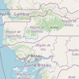
Map view of Bijilo National Park

Use this park location map to pinpoint Bijilo National Park in Gambia, understand its exact geographic position, and read its mapped placement within the surrounding landscape more clearly.

Pigeon | © OpenStreetMap contributors
Park atlas

Trace the broader protected landscape and regional geography surrounding Bijilo National Park in West Africa

Explore Nearby National Parks and Protected Areas Beyond Bijilo National Park

Browse a curated selection of national parks and protected areas located in the region surrounding Bijilo National Park, offering diverse coastal ecosystems and forest fragments across West Africa. Compare mapped geography and conservation landscapes to understand the regional spread of protected zones, identifying other natural areas for further exploration.
National parkGambia
About 9.7 km away#1 closest

Southeast

Abuko National Park: Key Protected Landscape and National Park in Gambia

Mapped terrain and regional geography within the park's boundaries.

Abuko National Park is a significant protected area within Gambia, offering a detailed view of its national park identity and geographic presence. This page provides essential atlas context for understanding the park's specific landscape character and its role as a mapped natural territory. Explore how this protected land contributes to the regional geography and provides a distinct environmental canvas for discovery.

Area
1.07 km²
Established
1968
Relief
Lowland
Climate
Tropical
Nature reserveGambia
About 9.7 km away#2 closest

Southeast

Abuko Nature Reserve: A Protected Nature Reserve in Gambia's Landscape

Explore its mapped boundaries and geographic context.

Abuko Nature Reserve is a protected natural area situated in Gambia, offering a distinct focus for understanding protected landscapes. This entry provides essential details for atlas-based discovery, highlighting the reserve's mapped boundaries and its role within the regional geography. Examine Abuko Nature Reserve to gain clarity on its protected status and its contribution to the mapped natural terrain of West Africa.

Area
1.07 km²
Established
1968
IUCN
IV
Relief
Lowland
National parkGambia
About 10 km away#3 closest

Southwest

Tanji Bird Reserve National Park: Coastal Wetlands and Avian Diversity in Gambia

Explore unique geography and protected landscape boundaries.

Tanji Bird Reserve National Park showcases a distinctive coastal landscape where the Atlantic Ocean meets lagoons, dry woodland, and dune scrub. This 612-hectare protected area in The Gambia is celebrated for its incredible birdlife, with nearly 300 species recorded, including significant Palearctic migrants and the nation's sole breeding seabird colonies on the Bijol Islands. The reserve offers a rich context for understanding West African protected areas, mapped terrain, and coastal ecosystem geography.

Area
6.12 km²
Established
1993
IUCN
II
Relief
Lowland
National parkGambia
About 12 km away#4 closest

East

Tanbi Wetland Complex National Park: A Mapped Protected Area in The Gambia

Explore its protected boundaries and regional landscape.

Delve into the geographic identity of Tanbi Wetland Complex National Park, a designated protected area within The Gambia. This page provides essential atlas-level information, focusing on its mapped natural landscape and its role as a significant national park. Understand the park's protected status and its geographical context along the Gambia River, offering a clear entry point for conservation landscape discovery.

Area
45 km²
Established
2001
IUCN
II
Relief
Lowland
National parkSenegal
About 18 km away#5 closest

North

Saloum Delta National Park: Detailed Map Exploration of Senegal's Protected Landscape

Explore the mapped boundaries and regional terrain of this national park.

Saloum Delta National Park, a designated national park in Senegal, serves as a key entity for understanding protected landscapes in West Africa. This entry focuses on its geographic specificities, providing mapped context and details about its natural terrain. Users can explore the park's boundaries and regional landscape character, contributing to a richer atlas-based discovery of Senegal's conservation areas and natural geography.

Area
760 km²
Established
1976
Relief
Lowland
Climate
Tropical
National parkGambia
About 25 km away#6 closest

Northeast

Niumi National Park: Gambia's Extensive Mangrove Forest and Coastal Wetland Protected Area

Explore the mapped boundaries and unique delta geography of this important national park.

Niumi National Park, situated in The Gambia, is a crucial protected coastal area celebrated for its vast Rhizophora mangrove forests and diverse wetland ecosystems. As a designated national park and Ramsar site, it serves as a critical habitat for numerous migratory bird species, particularly terns, and supports vulnerable marine life. Its landscape is characterized by tidal channels, brackish lagoons, and intertidal mudflats, creating a dynamic and ecologically significant protected zone that is a focal point for understanding West African coastal geography and conservation.

Area
49.4 km²
Established
1987
IUCN
II
Relief
Lowland
National parkGambia
About 88 km away#7 closest

East

Kiang West National Park: National Park Detail and Protected Landscape Geography

Explore mapped boundaries and regional context in The Gambia.

Kiang West National Park serves as a crucial point for understanding protected natural areas within The Gambia, West Africa. This national park's identity is rooted in its geographic setting along the Gambia River, offering a distinct landscape context and mapped territory. Users can explore its boundaries and place within the nation's conservation network, contributing to a structured understanding of regional geography and protected lands.

Area
115 km²
Established
1987
IUCN
II
Relief
Lowland
Wildlife reserveGambia
About 94 km away#8 closest

East

Bao Bolong Wetland Reserve: West African Wildlife Reserve with Extensive Mangrove Ecosystems

Explore mapped terrain and crucial protected wetland boundaries.

Bao Bolong Wetland Reserve in Gambia is a significant protected area renowned for its ecological importance as a Ramsar wetland and Important Bird Area. This wildlife reserve features the tallest mangrove trees in the Senegambia region, transitioning through salt marshes to savanna, all centered around the Bao Bolong tributary's estuary. Its complex hydrological network and diverse habitats support 268 bird species and are crucial for the endangered West African manatee, offering a rich landscape for geographic and protected-area discovery.

Area
220 km²
Established
1996
IUCN
VI
Relief
Lowland

Common questions about visiting, size, designation, and location context for Bijilo National Park

Bijilo National Park FAQs for park facts, access, geography, and protected area context

Find quick answers about Bijilo National Park, including protected-area facts, park geography, trail and visitor context, and how the park fits into its surrounding country and regional landscape.
MoriAtlas Explorer

Continue Your Protected Areas Search Across the Global Atlas

Deepen your exploration by continuing the structured search for national parks and protected areas worldwide. Utilize the comprehensive filtering capabilities to compare different conservation landscapes and refine your understanding of global park geography. Discover more about the distribution and characteristics of protected natural areas.

Global natural geography