Why Bikar Atoll stands out
Bikar is best known as one of the most important seabird nesting islands in the Marshall Islands and as a major nesting beach for the endangered green turtle. A 1988 survey recorded breeding populations of great frigatebirds, red-footed boobies, masked boobies, brown boobies, white terns, brown noddies, sooty terns, and both red-tailed and white-tailed tropicbirds, alongside over 250 green turtle nesting sites on its beaches. The combination of a near-continuous reef, a single narrow pass, and a perched lagoon also gives Bikar a distinctive oceanographic character shared only with the neighboring Taongi Atoll. Equally central to the atoll's identity is its near-pristine ecological condition. Because Bikar has never supported a resident population and has remained largely free of intensive land use, its surviving patches of native atoll forest, including pandanus, Pisonia, Scaevola, and beach morning glory communities, reflect the original vegetation patterns of a remote Micronesian atoll more clearly than most other Marshall Islands landforms. This makes the atoll a critical reference site for island ecology, seabird conservation, and sea turtle recovery efforts across the wider Pacific.
Bikar Atoll history and protected-area timeline
Bikar Atoll was almost certainly visited by Marshallese communities well before sustained Western contact. Although there is no archaeological evidence that anyone ever lived on the atoll permanently, traditional accounts indicate that it was used for centuries as a hunting and gathering ground, particularly for seabirds and sea turtles, by inhabitants of the neighboring Utirik and Maloelap atolls. Together with the other uninhabited northern Ratak atolls of Bokak and Toke, Bikar was traditionally the hereditary property of the Ratak iroijlaplap, and exploitation of its marine and bird resources was regulated by customary rules enforced by the traditional chiefs.
The atoll enters the written historical record at the beginning of the nineteenth century, during the era of European exploration of the Pacific. The Russian brig Rurik, commanded by Otto von Kotzebue, sighted Bikar in the summer of 1817 while searching for a northern passage between Russia and its North American territories. The French corvette Danaide under Captain J. de Rosamel visited during a hydrographical survey in August 1840. By the late nineteenth century, Bikar had come into the orbit of European commercial interests in the Marshall Islands: it was sold to Adolph Capelle and Company in 1880, transferred to the Deutsche Handels und Plantagengesellschaft in 1883, and then absorbed into the German colonial administration after the 1885 annexation of the Marshall Islands. German property rights were reorganized under the Jaluit Gesellschaft in 1887.
Japanese forces occupied the Marshall Islands in 1914, and the atoll came under the South Seas Mandate. Like the Germans, the Japanese administration did not attempt to develop Bikar, and northern Ratak communities continued to visit the atoll for traditional hunting and fishing. After the Second World War the atoll became part of the United States-administered Trust Territory of the Pacific Islands. Bikar's most consequential twentieth-century event was the fallout from the Castle Bravo nuclear test at Bikini Atoll in March 1954, whose plume passed over the atoll about twenty hours after the detonation; later surveys found residual contamination, although levels were far lower than on directly affected atolls such as Rongelap. In 1962, nineteen Japanese fishermen from the Daitei Maru No. 15 were marooned on Bikar for several days before being rescued by the U.S. Coast Guard. In 2025 the atoll was included in the Marshall Islands' first designated marine sanctuary, concurrent with the successful eradication of introduced rats.
Bikar Atoll landscape and geographic character
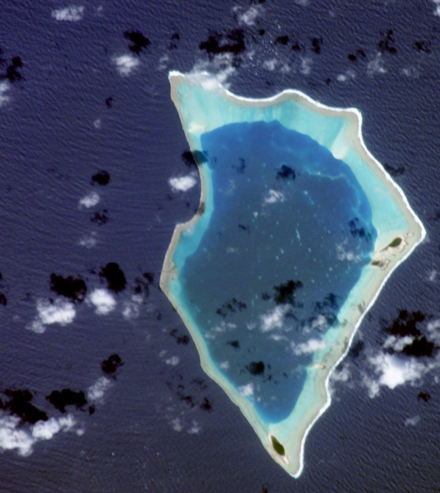
Bikar Atoll has the classic morphology of a remote central Pacific coral atoll: a roughly diamond-shaped ring of low coral islets surrounding a shallow interior lagoon, with a continuous reef on the ocean side broken by only one narrow pass. The islets together total less than half a square kilometer of dry land, while the enclosed lagoon covers about 37 square kilometers, giving Bikar an exceptionally high ratio of lagoon to land. The largest islet, also called Bikar, rises only about six meters above sea level, and none of the landforms approach anything that could be called a hill or ridge.
The surrounding reef is believed to sit atop a very thick sequence of ancient coral material overlying a basalt base formed by the original volcanic foundation of the island. Comparison with drill cores taken at Enewetak Atoll suggests Bikar's reef may contain several thousand feet of accumulated carbonate on top of basalt that rises roughly ten thousand feet from the surrounding ocean floor, indicating a long history of slow subsidence. The reef flat encloses the lagoon almost completely, and prevailing north to north-easterly trade winds drive enough water over the reef to perch the lagoon about half a meter above the mean open-ocean tide level, a feature Bikar shares with Taongi Atoll.
The islets themselves are narrow strips of coral rubble and sand supporting low scrub and a few surviving coconut palms planted by visiting Marshallese from Utirik. There are no rivers, streams, or true freshwater features; rainfall is too low and the substrate too porous for a stable Ghyben-Herzberg lens to form across most of the atoll. Sandy beaches ring the seaward edge and provide the nesting habitat that has made Bikar important for green turtles and seabirds. The dominant impression is of an exposed, arid, low-lying ring of land tightly locked to its reef, with the lagoon as the atoll's central, sheltered feature.
Bikar Atoll ecosystems, habitats, and plant life
The natural environment of Bikar Atoll has been described as one of the closest surviving examples of a near-pristine Marshall Islands ecosystem, shaped by the combination of human absence, arid conditions, and repeated storm disturbance. Native plant communities reflect classic atoll forest and scrub associations, including pandanus, Pisonia grandis, Scaevola sericea, Tournefortia argentea, Boerhavia repens, Lepturus repens, Portulaca lutea, and Triumfetta procumbens, along with areas of vine and atoll scrub. Coconut palms survive in small numbers from plantings by visitors from Utirik, although conditions produce only small nuts with bitter milk.
The climate is semi-arid by Marshall Islands standards, with mean annual rainfall of less than about 45 inches concentrated mainly in the July to October rainy season, and persistent north to north-easterly trade winds. Temperatures remain close to 28 degrees Celsius year-round. These conditions, combined with porous coral substrates, prevent the formation of a reliable freshwater lens across most of the atoll. Major cyclones are a recurring disturbance; a tropical cyclone in the late 1970s, possibly Typhoon Mary in 1977, devastated much of Bikar's Pisonia forest, an event considered a natural part of the atoll's dynamics.
Within this harsh, storm-shaped setting, Bikar supports unusually important animal populations. The terrestrial and reef environment together support breeding seabirds, nesting green turtles, reef corals with some genera absent from neighboring Taongi Atoll, a richer fish fauna including two-spot red snapper, humpback red snapper, leopard grouper, and humphead parrotfish, and shellfish such as black-lipped pearl oyster, bear paw clam, maxima clam, and the Trochus sea snail. The combination of arid land, sheltered lagoon, and intact reef communities makes the atoll a benchmark for understanding how a remote Micronesian island ecosystem functions with minimal direct human influence.
Bikar Atoll wildlife and species highlights
Bikar Atoll is internationally recognized primarily for its wildlife. It is one of the most important seabird nesting sites in the Marshall Islands, supporting breeding populations of great frigatebirds and red-footed boobies in particular, along with masked boobies, brown boobies, white terns, brown noddies, and sooty terns. Both red-tailed and white-tailed tropicbirds breed on the atoll, and migrant shorebirds such as ruddy turnstones, wandering tattlers, bristle-thighed curlews, Pacific golden plovers, and Pacific reef herons visit in smaller numbers. A 1969 survey recorded twenty-three bird species in total, of which nineteen were still observed in a follow-up count in 1988, although the loss of much of the Pisonia forest is thought to have reduced numbers of tree-nesting frigatebirds and boobies.
The atoll is also a major nesting site for the endangered green turtle, with over 250 nesting sites recorded during the 1988 survey. The narrow, sandy islets and sheltered lagoon platform provide exactly the kind of habitat the species depends on, and the absence of a resident human population means nesting beaches have been largely free of regular disturbance. The reef and lagoon fauna complement the terrestrial and beach wildlife, including a mix of reef fish, reef-building corals, and shellfish that are characteristic of remote Pacific atolls. No marine mammals have been recorded in the lagoon.
Wildlife management on Bikar has focused on invasive species. The Polynesian rat was historically common on Bikar and Jabwelo, but by 1993 a population explosion of more aggressive non-Polynesian rats, most likely introduced by Asian fishing trawlers operating illegally near the atoll, had raised serious concerns for seabird and turtle nesting success. In 2025, rats were successfully eradicated from the atoll, with early signs of recovery in both bird populations and native vegetation. This makes Bikar one of the few large Marshall Islands atolls where direct ecological restoration of a near-intact system is now underway.
Bikar Atoll conservation status and protection priorities
Bikar Atoll holds considerable conservation significance precisely because so little of its original ecological character has been lost. Its isolation, lack of permanent human settlement, and limited exposure to introduced species have allowed large breeding aggregations of seabirds and endangered green turtles to persist on a scale that is unusual in the modern Marshall Islands. The atoll functions as a reference site for what undisturbed atoll ecosystems looked like before widespread human modification, and it is frequently cited in environmental surveys for that reason.
The most important conservation threats have come from outside the atoll rather than from within it. Tropical cyclones periodically reshape vegetation, most notably the late-1970s event that destroyed much of the Pisonia forest, and illegal foreign fishing vessels operating near Bikar are believed to have introduced more aggressive rat species that exploded in numbers during the 1990s. Concerns that these rats could undermine seabird and sea turtle breeding drove planning for eradication, which was successfully carried out in 2025. In the same year, Bikar was included in the Marshall Islands' first designated marine sanctuary, formalizing its protected status and aligning it with broader national efforts to safeguard marine biodiversity.
The atoll's conservation value extends beyond its own beaches. Because rainbow fallout from the 1954 Castle Bravo nuclear test passed over Bikar, the atoll has provided one of the most thoroughly documented data sets on distant nuclear fallout in the Pacific, and later studies of fish and invertebrates within its lagoon found that residual radioactivity remained within the range of imported seafood products. While that history is mainly scientific rather than ecological, it underscores the atoll's broader relevance as a long-term environmental monitoring site in addition to its role as a wildlife refuge.
Bikar Atoll cultural meaning and human context
Bikar Atoll has a distinctive cultural position within the Marshall Islands. Although there is no archaeological evidence of permanent habitation, tradition records that the atoll, together with Bokak (Taongi) and Toke, formed part of the hereditary holdings of the Ratak iroijlaplap, the high chief of the northern Ratak Chain. This customary ownership organized how local communities could exploit the atoll's seabirds, sea turtles, and eggs, with harvesting rules overseen by the iroij and other traditional leaders.
In everyday practice, Bikar has long functioned as a shared seasonal resource for nearby communities, particularly Utirik and Maloelap. Islanders from these atolls would travel to Bikar to hunt seabirds and collect their eggs, fish in the lagoon, and harvest nesting green turtles under the customary framework. Coconuts planted by visiting Utirik islanders survived on the atoll, even though rainfall was too low to support traditional breadfruit or taro cultivation. This pattern of seasonal use, combined with the absence of permanent settlement, explains why Bikar carries so few visible human traces today and why the atoll's present-day significance is overwhelmingly ecological rather than built or archaeological.
In the modern era, Bikar's cultural footprint is dominated by its history of external contacts. Nineteenth-century European explorers, including the crew of the Russian brig Rurik and the French corvette Danaide, visited the atoll and recorded its position. Twentieth-century visitors ranged from German commercial interests and Japanese colonial administrators to stranded Japanese fishermen, U.S. military expeditions, and the fallout plume from the Castle Bravo nuclear test. The corroded wreck of a Japanese fishing boat visible in the north fork of the reef passage serves today as one of the few material reminders of this layered modern history on an otherwise undisturbed atoll landscape.
Top sights and standout views in Bikar Atoll
Bikar Atoll combines an extreme degree of geographic isolation with a near-intact atoll ecosystem whose central features are an almost entirely enclosed lagoon, a continuous reef with a single narrow pass, and low, arid islets that have never supported permanent settlement. These conditions support breeding populations of frigatebirds, boobies, tropicbirds, terns, and noddies, as well as more than 250 nesting sites for the endangered green turtle. Vegetation patterns reflect classic atoll forest and scrub communities, with pandanus, Pisonia, Scaevola, and surviving coconut palms shaping a low, exposed land surface.
Bikar also stands out for the layered history etched into its reefs and records. Nineteenth-century European expeditions charted its position, German and Japanese administrations administered it without developing it, the fallout plume from the 1954 Castle Bravo test crossed the atoll, and American and Japanese ships occasionally came ashore. The 2025 eradication of introduced rats, alongside the designation of Bikar as part of the Marshall Islands' first marine sanctuary, marks a new chapter in which one of the most ecologically intact atolls in the Pacific is also receiving formal, long-term protection.
Best time to visit Bikar Atoll
Bikar Atoll has no permanent population, no regular public transport, and no routine tourism infrastructure, so describing access in operational terms is difficult. In broad ecological terms, the atoll's character shifts mainly with the rainy season, which runs roughly from July through October and brings most of the annual rainfall of under about 45 inches. Outside that window, conditions are drier and warmer, and seabird and sea turtle activity continues year-round.
Cyclones remain the dominant disturbance for the atoll and can reshape vegetation, beach profiles, and wildlife conditions over short timescales. The period that avoids the main cyclone risk for central North Pacific atolls typically falls outside the July to October rainy season, although specific storm patterns vary by year. Because Bikar's recovery from disturbances such as the 1977 Pisonia forest loss has been measured in years, any visit or survey effort is best treated as a long-term ecological experience shaped by weather, breeding cycles, and recent restoration work rather than a short seasonal excursion.