

Mori Atlas logo
National parkBlack Sound Cay National Reserve

Map the protected boundaries and discover the geographic character of this Bahamian national park.

Black Sound Cay National Reserve: National Park Protected Landscape in North Abaco, Bahamas

Black Sound Cay National Reserve represents a significant protected natural area within the North Abaco region of the Bahamas. As a national park, its designation underscores its role in preserving the island's unique landscape. This page offers an atlas-driven view, focusing on the park's mapped boundaries and its contribution to the regional geography of the Abaco Islands, providing essential context for landscape exploration.

Mangrove EcosystemStrict Nature ReserveBird HabitatMarine NurseryCaribbean IslandsCoastal Protected Area

Black Sound Cay National Reserve

National park

Park overview

Structured park overview, official facts, and landscape profile for Black Sound Cay National Reserve

Black Sound Cay National Reserve park facts, protected area profile, and essential visitor context
Review the core facts for Black Sound Cay National Reserve, including designation, size, terrain, visitor scale, habitats, and operating context in one park-focused overview.

About Black Sound Cay National Reserve

Black Sound Cay National Reserve occupies a coastal position on Green Turtle Cay, one of the islands in the Abaco archipelago of the Bahamas. The reserve was established in 1988 through the efforts of the Bahamas National Trust, the primary organization responsible for managing protected areas throughout the Bahamas. Despite its modest area of only 2 acres, the reserve represents a significant conservation asset within the island chain, protecting a functioning mangrove ecosystem that would otherwise be vulnerable to development pressures. The mangrove forest within the reserve comprises multiple species working together to create a complex habitat structure. Red mangroves provide the iconic prop root systems that extend into the water, white mangroves contribute to the canopy layer, black mangroves add structural diversity, and buttonwood rounds out the plant community. This layered vegetation creates microhabitats that support both terrestrial and aquatic species. The sheltered waters created by the mangrove root systems serve as nursery areas for juvenile fish and shellfish, supporting the broader marine food web and contributing to the health of surrounding waters.

Quick facts and research context for Black Sound Cay National Reserve

Black Sound Cay National Reserve is a 2-acre strict nature reserve on Green Turtle Cay in the Bahamas, established in 1988 and managed by the Bahamas National Trust. The protected area centers on a mangrove ecosystem that provides crucial habitat for marine species and birds. The reserve is classified as IUCN Category Ia, indicating its strict nature reserve status with minimal human interference. Located at approximately 26.7597°N, 77.3205°W, the reserve occupies a coastal position within the island environment.

Park context

Deeper park guide and search-rich context for Black Sound Cay National Reserve

Black Sound Cay National Reserve history, landscape, wildlife, and travel context
Explore Black Sound Cay National Reserve through its history, landscape character, ecosystems, wildlife, conservation priorities, cultural context, and seasonal travel timing in a structured park guide built for atlas discovery and search intent.

Why Black Sound Cay National Reserve stands out

Black Sound Cay National Reserve is best known for its dense mangrove forest that serves as a natural nursery for marine species including groupers, crawfish, and conch. The reserve provides important habitat for resident bird species such as the white-cheeked pintail and West Indian whistling duck, while also serving as a crucial stopover and wintering area for migratory songbirds including painted bunting, indigo bunting, American redstart, black-and-white warbler, and magnolia warbler. The compact size of the reserve combined with its ecological richness makes it a notable example of how island mangrove systems support disproportionate biodiversity value.

Black Sound Cay National Reserve history and protected-area timeline

Black Sound Cay National Reserve was established on November 1, 1988, as part of the Bahamas National Trust's expanding network of protected areas across the archipelago. The creation of this reserve reflected a growing recognition within the Bahamas of the ecological importance of mangrove systems, which had historically been viewed as swampland to be drained or developed. The Bahamas National Trust, as the governing body for the reserve, has maintained the protected status of this area while working to balance conservation with sustainable use of natural resources throughout the Bahamas. The establishment of the reserve also contributed to the broader Caribbean effort to protect critical coastal habitats, as mangrove forests across the region face pressures from coastal development, tourism infrastructure, and climate change impacts.

Black Sound Cay National Reserve landscape and geographic character

The landscape of Black Sound Cay National Reserve is defined by its mangrove forest ecosystem occupying a coastal fringe on Green Turtle Cay. The terrain is low-lying and flat, characteristic of the Bahamian island environment, with the mangrove area transitioning between terrestrial and marine zones. The red mangroves dominate the water's edge with their distinctive prop roots creating a lattice-like structure that extends into the tidal waters. Behind these, white and black mangroves form a denser canopy, while buttonwood occupies higher ground at the forest's inland edge. The water channels and pools within the mangrove system create a labyrinthine environment that fluctuates with tidal cycles, with the rooted areas providing stable substrates for marine organisms while the open water areas serve as feeding and nursery zones.

Black Sound Cay National Reserve ecosystems, habitats, and plant life

The nature of Black Sound Cay National Reserve centers on a functional mangrove ecosystem that exemplifies the ecological productivity of tropical coastal habitats. The three main mangrove species present—red, white, and black—each occupy different zones within the tidal gradient, creating a vertically stratified community. Red mangroves thrive in the wettest areas closest to the water, their aerial roots providing structure and oxygen exchange. White mangroves typically occupy the middle zone, while black mangroves are often found in areas with less frequent tidal inundation. Buttonwood completes the plant community in the driest areas. This mangrove forest supports a detritus-based food chain that forms the foundation of coastal productivity in the Bahamas, with fallen leaves and organic matter fueling microbial communities that in turn support fish, crustaceans, and other marine organisms.

Black Sound Cay National Reserve wildlife and species highlights

The wildlife value of Black Sound Cay National Reserve extends across both marine and terrestrial realms. Within the sheltered mangrove waters, juvenile groupers, crawfish, and conch find refuge among the root systems, benefiting from the protection from predators and the rich food resources that the mangrove ecosystem provides. The canopy and forest floor support bird populations both resident and migratory. Resident species include the white-cheeked pintail, a dabbling duck adapted to Caribbean wetlands, and the West Indian whistling duck, a largely nocturnal species that roosts in the mangrove vegetation. The reserve also attracts numerous migratory songbirds during their wintering season, including the painted bunting, known for the male's brilliant coloration, the indigo bunting, and several warbler species including American redstart, black-and-white warbler, and magnolia warbler. These migratory species rely on the mangrove habitat for rest and refueling during their journeys between North America and their tropical wintering grounds.

Black Sound Cay National Reserve conservation status and protection priorities

Black Sound Cay National Reserve represents a small but significant contribution to the Bahamas' protected area network, with its IUCN Category Ia designation indicating strict nature reserve status that limits human activities to non-destructive research and observation. The conservation value of this reserve is disproportionately high relative to its size, as mangrove ecosystems rank among the most biologically productive habitats on Earth. Protecting this area ensures that the ecological functions of the mangrove system—including carbon sequestration, coastal protection, water quality maintenance, and biodiversity support—continue to operate. The reserve also contributes to the wider Caribbean goal of maintaining connected coastal habitats that support migratory species and sustain marine food webs. As climate change intensifies pressures on island ecosystems, protected areas like this one provide resilience by maintaining functional natural systems.

Black Sound Cay National Reserve cultural meaning and human context

Black Sound Cay National Reserve is situated on Green Turtle Cay, an island with historical connections to the name 'turtle' reflecting the presence of sea turtles in surrounding waters. The Bahamas has a long maritime history tied to the sea, and the traditional use of marine resources including fishing has shaped the relationship between local communities and the coastal environment. The reserve's protection of mangrove nursery areas supports the continued health of fish and shellfish populations that local fishing communities depend upon, creating a direct link between conservation and sustainable livelihoods. The Bahamas National Trust's management approach reflects both international conservation standards and local awareness of how protected areas integrate with community life on the islands.

Top sights and standout views in Black Sound Cay National Reserve

The highlights of Black Sound Cay National Reserve include its role as a bird habitat of international significance, particularly for migratory songbirds traversing the Caribbean flyway. The dense mangrove forest supports a remarkable diversity of bird species in a very small area, making it an excellent example of the high biodiversity value that intact mangrove systems provide. The marine nursery function of the reserve supports commercially important species including groupers and conch, linking the protected area to the broader marine economy of the Abaco region. The strict nature reserve designation ensures that the ecosystem remains relatively undisturbed, allowing natural ecological processes to continue with minimal human intervention.

Best time to visit Black Sound Cay National Reserve

The best time to observe wildlife at Black Sound Cay National Reserve depends on the target species and visitor interests. Migratory birds are most present during the fall and winter months, roughly from September through April, when species like painted bunting, indigo bunting, and various warblers can be found in the mangrove habitat. The wet season in the Bahamas runs from May through October, coinciding with warmer temperatures and higher humidity but also offering the greenest mangrove foliage. Resident bird species such as the white-cheeked pintail and West Indian whistling duck can be observed year-round, though they may be more active during cooler parts of the day. The compact size of the reserve allows for thorough exploration regardless of season, though visitors should be prepared for typical tropical conditions including sun exposure and occasional rain.
Park location guide

Geography guide, regional context, and park location map for Black Sound Cay National Reserve

Black Sound Cay National Reserve park geography, regions, and map view in Bahamas
Understand where Black Sound Cay National Reserve sits in Bahamas through a broader geographic reading of the surrounding landscape, nearby location context, and its mapped position within the national park landscape.

How Black Sound Cay National Reserve fits into Bahamas

The Bahamas is an island nation in the Atlantic Ocean, forming part of the Lucayan Archipelago. It consists of more than 3,000 islands, cays and islets located north of Cuba, northwest of Hispaniola, and southeast of Florida. The country gained independence from Britain in 1973 and operates as a constitutional monarchy under King Charles III, with Nassau as its capital and largest city.

Wider geography shaping Black Sound Cay National Reserve in Bahamas

The Bahamas occupies the Lucayan Archipelago in the Atlantic Ocean. The island chain is positioned north of Cuba, northwest of Hispaniola (shared by the Dominican Republic and Haiti), southeast of the US state of Florida, and east of the Florida Keys. The territory spans over 3,000 islands, cays and islets, with the total land area being 13,943 km². The Royal Bahamas Defence Force claims approximately 470,000 km² of surrounding ocean space.

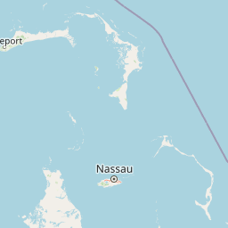
Map view of Black Sound Cay National Reserve

Use this park location map to pinpoint Black Sound Cay National Reserve in Bahamas, understand its exact geographic position, and read its mapped placement within the surrounding landscape more clearly.

Pigeon | © OpenStreetMap contributors

Location context for Black Sound Cay National Reserve

North Abaco
Park atlas

Explore the diverse coastal protected landscapes and marine ecosystems throughout the wider Bahamian islands geography

Discover Other National Parks and Protected Areas Near Black Sound Cay National Reserve
After exploring Black Sound Cay National Reserve, browse other protected areas within the Bahamas, tracing similar mangrove ecosystems and vital bird habitats. Deepen your understanding of island conservation and coastal landscapes by comparing these distinct, yet geographically connected, protected natural areas.
National parkBahamas

Fowl Cays National Park: Bahamas Marine Protected Area and Coral Reef Atlas

Discover the mapped geography and marine ecosystems of this Bahamian national park.

Fowl Cays National Park in the Bahamas is a protected marine environment known for its significant coral reef formations and supporting seagrass meadows. This atlas-focused entry details the park's geographic setting within the Abaco Islands, highlighting its importance as a marine conservation landscape. Users can explore the protected boundaries and the ecological richness of this vital Caribbean ecosystem.

Area
9 km²
Established
2009
IUCN
II
Climate
Subtropical
Nature reserveHope Town

Tilloo Cay National Reserve Nature Reserve: Coastal Habitat for White-Tailed Tropicbirds

Mapped protected area within the Hope Town region of the Abacos.

Tilloo Cay National Reserve, a protected nature reserve situated near Hope Town, represents a significant habitat for the white-tailed tropicbird, a species reliant on such island nesting sites. This 11-acre reserve showcases a characteristic Bahamian small island ecosystem, featuring coastal terrain and scrub vegetation. Its protected status under the Bahamas National Trust ensures the security of critical breeding grounds, making it a key focus for conservation within the Abaco Islands. The reserve offers a distinct example of targeted habitat preservation, contributing to the broader atlas of protected natural landscapes in the Caribbean.

Area
0.04 km²
Established
1990
IUCN
II
Relief
Lowland
National parkBahamas

Pelican Cays Land and Sea Park: Protected Marine Landscape in the Bahamas

Explore coral reefs, undersea caves, and vital sea turtle habitats.

Pelican Cays Land and Sea Park, a protected national park in the Bahamas, offers a rich marine atlas experience. Its landscape is defined by extensive coral reef formations and unique undersea cave systems, supporting remarkable biodiversity. This park highlights the importance of protected waters for species like sea turtles and provides exceptional opportunities for exploring submerged geography and vibrant coral ecosystems.

Area
8 km²
Established
1972
IUCN
II
Relief
Lowland
National parkSouth Abaco

Abaco National Park: Bahamian National Park with Mapped Protected Landscape

Explore its geographic setting and protected area boundaries.

Abaco National Park stands as a designated national park within the Bahamas, contributing to the conservation of its unique protected landscapes. This entry provides detailed insights into its geographic positioning in South Abaco, focusing on the mapped extent of its protected area and its broader regional landscape context for atlas exploration.

Area
83 km²
Established
1994
Climate
Tropical
Scope
Terrestrial
National parkGrand Bahama

Lucayan National Park: National Park Geography and Mapped Landscape Exploration

Discover protected area boundaries on Grand Bahama.

Lucayan National Park stands as a distinct national park entity within the geography of Grand Bahama. This page provides a focused atlas-style exploration of the park's protected landscape, detailing its mapped area and contributing to a structured understanding of its regional context. Delve into the geographic specifics that define Lucayan National Park as a key element of the Bahamas' protected lands, suitable for detailed map-based discovery and analysis.

Area
7.84 km²
Established
1982
IUCN
II
Climate
Tropical
National parkBahamas

Walker's Cay National Park: Bahamas National Park Featuring a Premier Barrier Reef Ecosystem

Explore mapped underwater geography and marine protected boundaries.

Walker's Cay National Park is a vital marine protected area located in the Bahamas, safeguarding approximately 3,840 acres of coastal and ocean waters. Its most distinguishing feature is the expansive barrier reef, a complex underwater geography teeming with diverse marine species that draws attention for diving and snorkeling. This park serves as a crucial element within the atlas of Bahamian protected lands, offering structured insights into marine conservation and the mapped distribution of critical reef habitats.

Area
16 km²
Established
2002
IUCN
II
Relief
Lowland
National parkBahamas

Primeval Forest National Park: A Protected Landscape within the Bahamas Archipelago

Explore mapped boundaries and regional geography in the Lucayan Archipelago.

Primeval Forest National Park serves as a key protected area within the Bahamas, offering a focused view of island geography and conservation landscapes. This national park is a critical element for understanding the archipelago's natural terrain and mapped protected lands. Its presence provides valuable geographic context, allowing for detailed exploration of its boundaries and its place within the broader Bahamian atlas.

Established
2002
Relief
Mixed relief
Climate
Tropical
Access
Easy access
National parkBahamas

Bonefish Pond National Park: Essential Bahamas Coastal Wetland & Marine Nursery

Mapped protected area, mangrove ecosystem, and habitat for key marine species.

Bonefish Pond National Park, a protected national park on New Providence island in The Bahamas, is essential for its role as a thriving marine nursery. The park's landscape features extensive red mangrove forests, tidal channels, and shallow lagoons crucial for juvenile bonefish, crawfish, and conch. This area highlights effective wetland restoration and conservation, offering valuable insights into Caribbean coastal protected landscapes and their geographic importance.

Area
5 km²
Established
2002
IUCN
II
Relief
Lowland

Common questions about visiting, size, designation, and location context for Black Sound Cay National Reserve

Black Sound Cay National Reserve FAQs for park facts, access, geography, and protected area context
Find quick answers about Black Sound Cay National Reserve, including protected-area facts, park geography, trail and visitor context, and how the park fits into its surrounding country and regional landscape.
MoriAtlas Explorer

Continue Your Protected Areas Search Across the Global Atlas

Deepen your exploration by continuing the structured search for national parks and protected areas worldwide. Utilize the comprehensive filtering capabilities to compare different conservation landscapes and refine your understanding of global park geography. Discover more about the distribution and characteristics of protected natural areas.

Global natural geography