

Mori Atlas logo
National parkBlue Holes National Park

Discover the protected landscape and mapped terrain of this Andros national park.

Blue Holes National Park: Detailed National Park Map and Geographic Exploration

Blue Holes National Park stands as a distinct protected area within the geographic landscape of Andros. This page offers a detailed atlas-style exploration, focusing on the park's mapped boundaries and its unique environmental context. Understand its placement within the regional geography of the Bahamas through structured park data and visual map exploration.

Blue holesCave ecosystemsPine forestsCaribbean protected areaSubterranean biodiversityBird habitat

Blue Holes National Park

National park

Park overview

Structured park overview, official facts, and landscape profile for Blue Holes National Park

Blue Holes National Park park facts, protected area profile, and essential visitor context
Review the core facts for Blue Holes National Park, including designation, size, terrain, visitor scale, habitats, and operating context in one park-focused overview.

About Blue Holes National Park

Blue Holes National Park occupies a significant portion of Andros Island in the Bahamas, a nation composed of more than 700 islands and cays scattered across the Atlantic Ocean. The park was formally established in 2002 through legislation that recognized the exceptional scientific and conservation value of Andros's blue hole formations and surrounding ecosystems. The Bahamas National Trust, the country's primary conservation organization, serves as the governing body responsible for managing the park's protected resources.

The park's landscape is characterized by the interplay between above-ground pine forests and the dramatic blue hole formations that punctuate the terrain. These blue holes form when the limestone bedrock of Andros dissolves over millions of years, creating vertical shafts that extend downward into the island's aquifer system. The water within these caves is often remarkably clear, creating the vivid blue coloration that gives the formations their name. Below the surface, these dark waters harbor remarkable biodiversity including specialized cavefish and invertebrates that have evolved in complete isolation.

The significance of Blue Holes National Park extends beyond its immediate geological features. The park serves as a critical conservation area within the Bahamas, protecting representative examples of the country's terrestrial and subterranean ecosystems. Andros itself is the largest island in the Bahamas, and its interior forests and wetlands remain relatively undeveloped compared to other islands in the archipelago, making the park's protection efforts particularly important for maintaining the country's natural heritage.

Quick facts and research context for Blue Holes National Park

Blue Holes National Park lies on Andros Island in the Bahamas, the largest island in the Bahamian archipelago. The park was established in 2002 under the management of the Bahamas National Trust, covering roughly 40,000 acres. Its defining features are the blue holes, vertical underwater cave systems that penetrate the island's limestone bedrock. The park contains thousands of acres of pine forest and supports at least six endemic bird species. The IUCN categorizes this protected area as Category II, reflecting its national park designation.

Park context

Deeper park guide and search-rich context for Blue Holes National Park

Blue Holes National Park history, landscape, wildlife, and travel context
Explore Blue Holes National Park through its history, landscape character, ecosystems, wildlife, conservation priorities, cultural context, and seasonal travel timing in a structured park guide built for atlas discovery and search intent.

Why Blue Holes National Park stands out

Blue Holes National Park is best known for its extraordinary blue holes, which are deep, vertical underwater caves that form distinctive circular sinkholes on the island's surface. These blue holes serve as windows into a hidden subterranean ecosystem containing unique cavefish and invertebrate species that have adapted to life in complete darkness. The park also protects extensive pine forests that harbor endemic Bahamian bird species including the Bahama oriole, great lizard cuckoo, western spindalis, western red-legged thrush, black-faced grassquit, and Cuban emerald. This combination of geological significance and ecological importance makes the park one of the Bahamas' most distinctive protected areas.

Blue Holes National Park history and protected-area timeline

Blue Holes National Park was established in 2002 as part of the Bahamas' broader effort to create a national park system that would protect the country's most significant natural areas. The creation of the park reflected growing recognition of the scientific importance of blue hole formations, which had attracted increasing attention from researchers studying the unique cave ecosystems they contain. The Bahamas National Trust, founded in 1969 to protect the country's natural environment, was designated as the managing authority for the new protected area.

Prior to formal protection, the blue holes and forests of Andros had been subject to limited scientific investigation. The recognition that these formations contained endemic species found nowhere else in the world added urgency to conservation efforts. The park's establishment also reflected the Bahamas' commitment to meeting international conservation obligations and participating in broader Caribbean environmental protection initiatives. Since its creation, the park has continued to serve as both a protected area and a site for ongoing scientific research into subterranean ecosystems.

Blue Holes National Park landscape and geographic character

The landscape of Blue Holes National Park is defined by its distinctive combination of karst topography and pine forest-covered terrain. Andros Island's foundation consists of limestone bedrock that has been shaped by millions of years of dissolution by groundwater, creating the characteristic blue hole formations that are the park's most notable geological feature. These vertical caves can descend dozens of meters below the surface, opening into larger underwater chambers that connect with the island's extensive aquifer system.

Above ground, the park's terrain is relatively flat, typical of low-lying Caribbean islands. Thousands of acres within the park are covered by pine forests, which are unusual in the Bahamas context and represent a significant habitat type within the archipelago. The forest canopy is interrupted by the dark mouths of blue holes, creating a landscape where the subterranean world is never far beneath the surface. Between the forested areas, the terrain includes patches of scrubland and the seasonal wetlands that characterize much of Andros's interior.

Blue Holes National Park ecosystems, habitats, and plant life

The ecological systems within Blue Holes National Park encompass both above-ground and subterranean environments, each supporting distinctive biological communities. The park's pine forests represent one of the more extensive forested areas in the Bahamas, providing habitat for a suite of bird species including several that are endemic to the Bahamian archipelago. These forests create a relatively dense canopy that supports understory species and provides nesting sites for ground-dwelling and arboreal birds.

The blue holes themselves represent a unique aquatic habitat type that supports remarkable biodiversity. The dark, nutrient-poor waters of these cave systems are home to specialized cavefish species and various invertebrates that have evolved adaptations to life in complete darkness. These organisms represent relict populations that have been isolated within the cave system for thousands of years, making them of significant scientific interest for understanding evolution in subterranean environments. The connection between the blue holes and the broader aquifer system means that these cave ecosystems are hydrologically linked to the island's groundwater resources.

Blue Holes National Park wildlife and species highlights

The wildlife of Blue Holes National Park is notable for the presence of endemic species in both its terrestrial and subterranean environments. Above ground, the pine forests provide crucial habitat for at least six bird species that are characteristic of the Bahamian avifauna. The Bahama oriole, great lizard cuckoo, western spindalis, western red-legged thrush, black-faced grassquit, and Cuban emerald all depend on the forest habitat that the park protects. Several of these species have limited distributions within the Bahamas, making the park's forest protection particularly important for their long-term survival.

Below the surface, the blue holes harbor specialized cavefish and invertebrate species that have adapted to the unique conditions of subterranean aquatic environments. These species have evolved in complete darkness over evolutionary timescales, developing characteristics that distinguish them from their surface-dwelling relatives. The scientific study of these cave ecosystems continues to reveal new information about the biodiversity hidden within Andros's blue hole systems.

Blue Holes National Park conservation status and protection priorities

Blue Holes National Park represents an important conservation priority within the Bahamas due to the unique combination of geological and biological resources it protects. The park's blue holes contain endemic species that exist nowhere else on Earth, making their protection essential for global biodiversity conservation. The subterranean cavefish and invertebrates found in these formations have evolved in isolation and represent irreplaceable components of the planet's biological heritage.

The pine forests of the park provide habitat for bird species with limited ranges, several of which are considered endemic to the Bahamas. Protecting these forest areas ensures that these species have suitable habitat for nesting, feeding, and reproduction. The park's designation as an IUCN Category II protected area reflects its national park status and the commitment to maintaining its natural values for future generations. The Bahamas National Trust continues to manage the park with the goal of balancing conservation with appropriate public access and educational opportunities.

Blue Holes National Park cultural meaning and human context

Blue Holes National Park is situated on Andros, the largest island in the Bahamas, which has been inhabited for centuries by peoples of African descent. While the park itself does not contain explicit cultural heritage sites, the broader Andros Island has a rich cultural history tied to its marine and terrestrial environments. The local communities have traditionally engaged with the island's natural resources, including fishing and small-scale agriculture, though the interior areas where the park is located have remained relatively sparsely populated.

The concept of blue holes holds cultural significance in Caribbean folklore and imagination, representing mysterious and powerful natural features. While the park's primary focus is on geological and ecological conservation, these cultural associations add depth to the landscape's meaning. The park's establishment in 2002 represented a modern recognition of the importance of protecting Andros's natural environment while maintaining connections to the island's cultural heritage.

Top sights and standout views in Blue Holes National Park

Blue Holes National Park offers visitors the opportunity to explore one of the Bahamas' most unique geological phenomena. The blue holes themselves, with their dramatically clear water and descending passages, represent natural wonders that are exceptional even within the Caribbean context. Above ground, the pine forests provide a contrasting environment that supports diverse birdlife and offers opportunities for wildlife observation. The park's dual focus on protecting subterranean cave ecosystems and terrestrial forest habitats makes it a comprehensive conservation area that represents multiple dimensions of Bahamian natural heritage.

Best time to visit Blue Holes National Park

The Bahamas enjoys a tropical climate year-round, with warm temperatures and relatively high humidity. The most comfortable period for outdoor exploration typically falls between November and April, when temperatures are slightly cooler and rainfall is reduced compared to the summer months. Visiting during the dry season provides more reliable conditions for exploring the park's trails and observing wildlife, though the park's blue holes can be appreciated in any season. The summer months from June through November bring higher temperatures and increased precipitation, including the potential for tropical storms, which may affect access and comfort for park visitors.
Park location guide

Geography guide, regional context, and park location map for Blue Holes National Park

Blue Holes National Park park geography, regions, and map view in Bahamas
Understand where Blue Holes National Park sits in Bahamas through a broader geographic reading of the surrounding landscape, nearby location context, and its mapped position within the national park landscape.

How Blue Holes National Park fits into Bahamas

The Bahamas is an island nation in the Atlantic Ocean, forming part of the Lucayan Archipelago. It consists of more than 3,000 islands, cays and islets located north of Cuba, northwest of Hispaniola, and southeast of Florida. The country gained independence from Britain in 1973 and operates as a constitutional monarchy under King Charles III, with Nassau as its capital and largest city.

Wider geography shaping Blue Holes National Park in Bahamas

The Bahamas occupies the Lucayan Archipelago in the Atlantic Ocean. The island chain is positioned north of Cuba, northwest of Hispaniola (shared by the Dominican Republic and Haiti), southeast of the US state of Florida, and east of the Florida Keys. The territory spans over 3,000 islands, cays and islets, with the total land area being 13,943 km². The Royal Bahamas Defence Force claims approximately 470,000 km² of surrounding ocean space.

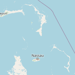
Map view of Blue Holes National Park

Use this park location map to pinpoint Blue Holes National Park in Bahamas, understand its exact geographic position, and read its mapped placement within the surrounding landscape more clearly.

Pigeon | © OpenStreetMap contributors

Location context for Blue Holes National Park

Andros
Park atlas

Compare neighboring protected areas and explore unique karst topography, pine forests, and diverse cave ecosystems across the Bahamian archipelago.

Explore Other National Parks and Protected Areas Near Blue Holes National Park in The Bahamas
After exploring Blue Holes National Park's unique blue holes and pine forests, continue browsing other national parks and protected areas across Andros Island and the broader Bahamian archipelago. Compare diverse conservation landscapes, including additional blue hole systems, diverse marine habitats, and crucial terrestrial forest reserves, to understand the regional spread of protected natural heritage.
National parkBahamas

North and South Marine Parks National Park: Geographic Atlas and Protected Landscape in the Bahamas

Mapping Bahamian protected marine geography and its national park boundaries.

Delve into the atlas-view of North and South Marine Parks, a key national park in the Bahamas. This page details the park's specific geographic features and its protected landscape identity within the island nation. Understand its placement and significance as a protected marine area contributing to the regional geography.

Area
20 km²
Established
2002
IUCN
II
Climate
Tropical
National parkAndros

Crab Replenishment Reserve National Park: Explore Andros Protected Landscape Boundaries

Mapped geography and regional park context

Investigate Crab Replenishment Reserve National Park, a significant protected landscape located in the Andros region. This page provides detailed atlas-style information, focusing on the park's mapped boundaries and its specific geographic setting. Understand how this national park contributes to the regional protected area network and its overall landscape identity for atlas-driven exploration.

Area
16 km²
Established
2002
IUCN
II
Relief
Lowland
National parkBahamas

Primeval Forest National Park: A Protected Landscape within the Bahamas Archipelago

Explore mapped boundaries and regional geography in the Lucayan Archipelago.

Primeval Forest National Park serves as a key protected area within the Bahamas, offering a focused view of island geography and conservation landscapes. This national park is a critical element for understanding the archipelago's natural terrain and mapped protected lands. Its presence provides valuable geographic context, allowing for detailed exploration of its boundaries and its place within the broader Bahamian atlas.

Established
2002
Relief
Mixed relief
Climate
Tropical
Access
Easy access
National parkBahamas

West Side National Park National Park: Extensive Protected Landscape in the Bahamas

Mapped marine and mangrove ecosystems, plus pine forest terrain

Delve into the geographical identity of West Side National Park, a protected national park in the Bahamas renowned for its vast scale and diverse ecosystems. This landscape features significant Caribbean pine forests transitioning into extensive, intact mangrove systems along its coastlines, integrating directly with vital marine habitats. As one of the largest protected areas in the Caribbean, its ecological representation from land to sea offers a unique atlas perspective on Bahamian natural heritage and conservation.

Area
6,070 km²
Established
2002
IUCN
II
Relief
Mixed relief
National parkBahamas

Bonefish Pond National Park: Essential Bahamas Coastal Wetland & Marine Nursery

Mapped protected area, mangrove ecosystem, and habitat for key marine species.

Bonefish Pond National Park, a protected national park on New Providence island in The Bahamas, is essential for its role as a thriving marine nursery. The park's landscape features extensive red mangrove forests, tidal channels, and shallow lagoons crucial for juvenile bonefish, crawfish, and conch. This area highlights effective wetland restoration and conservation, offering valuable insights into Caribbean coastal protected landscapes and their geographic importance.

Area
5 km²
Established
2002
IUCN
II
Relief
Lowland
National parkBahamas

Exuma Cays Land and Sea Park National Park: Mapped Protected Landscape in the Bahamas

Explore its geographic identity and atlas context.

This page provides detailed map-based information on Exuma Cays Land and Sea Park, a significant national park located in the Bahamas. Discover its protected area boundaries, explore its unique geographic setting within the archipelago, and understand its role as a key natural landscape. The content is geared towards atlas exploration, offering a factual overview of the park's spatial and regional importance without any visitor logistics or operational details.

Area
455.84 km²
Established
1959
Relief
Lowland
Climate
Tropical
National parkSouth Abaco

Abaco National Park: Bahamian National Park with Mapped Protected Landscape

Explore its geographic setting and protected area boundaries.

Abaco National Park stands as a designated national park within the Bahamas, contributing to the conservation of its unique protected landscapes. This entry provides detailed insights into its geographic positioning in South Abaco, focusing on the mapped extent of its protected area and its broader regional landscape context for atlas exploration.

Area
83 km²
Established
1994
Climate
Tropical
Scope
Terrestrial
National parkBahamas

Pelican Cays Land and Sea Park: Protected Marine Landscape in the Bahamas

Explore coral reefs, undersea caves, and vital sea turtle habitats.

Pelican Cays Land and Sea Park, a protected national park in the Bahamas, offers a rich marine atlas experience. Its landscape is defined by extensive coral reef formations and unique undersea cave systems, supporting remarkable biodiversity. This park highlights the importance of protected waters for species like sea turtles and provides exceptional opportunities for exploring submerged geography and vibrant coral ecosystems.

Area
8 km²
Established
1972
IUCN
II
Relief
Lowland

Common questions about visiting, size, designation, and location context for Blue Holes National Park

Blue Holes National Park FAQs for park facts, access, geography, and protected area context
Find quick answers about Blue Holes National Park, including protected-area facts, park geography, trail and visitor context, and how the park fits into its surrounding country and regional landscape.
MoriAtlas Explorer

Continue Your Protected Areas Search Across the Global Atlas

Deepen your exploration by continuing the structured search for national parks and protected areas worldwide. Utilize the comprehensive filtering capabilities to compare different conservation landscapes and refine your understanding of global park geography. Discover more about the distribution and characteristics of protected natural areas.

Global natural geography