

Mori Atlas logo
Nature reserveBoolcoomatta Reserve

A detailed look at the arid-zone geography, Acacia woodlands, and rocky ranges of this protected nature reserve.

Boolcoomatta Reserve: Mapping Protected Arid Landscapes and Conservation Terrain in South Australia

Boolcoomatta Reserve preserves a vast, intact slice of the South Australian outback, spanning undulating rocky ranges and extensive chenopod shrublands. This nature reserve, situated between Adelaide and Broken Hill, functions as a critical refuge for arid-zone bird populations and recovering native mammals. By analyzing its mapped boundaries and diverse microhabitats, such as dry river red gum creek lines, one can better understand the ecological structure of this significant private conservation area.

arid landscapeprivate reserveoutback South Australiachenopod shrublandAcacia woodlandtussock grassland

Boolcoomatta Reserve

Nature reserve

Park overview

Structured park overview, official facts, and landscape profile for Boolcoomatta Reserve

Boolcoomatta Reserve park facts, protected area profile, and essential visitor context

Review the core facts for Boolcoomatta Reserve, including designation, size, terrain, visitor scale, habitats, and operating context in one park-focused overview.

About Boolcoomatta Reserve

Boolcoomatta Reserve occupies a remote corner of the South Australian outback, in the transitional zone between the pastoral arid lands of the state's north-east and the broader landscape that runs toward Broken Hill in western New South Wales. The reserve lies 463 kilometres north-east of Adelaide and about 100 kilometres west of Broken Hill, near the small township of Olary, which serves as the closest service point. This positioning places it firmly within one of Australia's most sparsely populated and ecologically distinctive regions.

For more than a century and a half before its current conservation role, the property functioned as a sheep station, at times carrying flocks as large as 90,000 head. Traces of small-scale copper mining are also part of the property's working history. That long pastoral legacy shaped both the vegetation patterns and the wildlife populations that survive today, and the transition to conservation management has been framed as a chance to allow degraded country to recover under more natural conditions.

Today Boolcoomatta is run by Bush Heritage Australia as a private protected area rather than as a government-managed national park. Its inclusion in Australia's National Reserve System, secured through a perpetual conservation covenant, gives the reserve a level of formal protection comparable with public conservation lands. Combined with its sheer size and its connectivity to neighbouring conservation estates, this status makes Boolcoomatta an important node in the wider network of arid-zone conservation in central eastern Australia.

The reserve's defining character comes from its arid climate, its modest average annual rainfall, and the way its landforms have shaped distinctive plant communities across the property. Together these features create the conditions for the kind of wildlife restoration outcomes that surveys have begun to document, including the recovery of native mammal and reptile populations after the cessation of heavy grazing pressure.

Quick facts and research context for Boolcoomatta Reserve

Boolcoomatta Reserve is a privately owned conservation reserve in eastern South Australia, near the border with New South Wales and within commuting distance of Olary. It was purchased by Bush Heritage Australia in 2006, with support from the Australian Government and Nature Foundation SA, ending roughly 150 years of use as a sheep station.

The reserve is part of Australia's National Reserve System and is classified as an IUCN Category II protected area, recognising its national-park-equivalent level of protection. The climate is arid, with a very low average annual rainfall, and the property straddles a mix of rocky ranges, open plains, and seasonal creek systems. Its inclusion in the Boolcoomatta, Bindarrah and Kalkaroo Stations Important Bird Area highlights its importance for bird conservation in the Australian outback.

Protection and recognition

Documented terrestrial protection scope and conservation designation records

Boolcoomatta Reserve Protection Status and International Recognition

Boolcoomatta Reserve maintains a recorded terrestrial protection scope within the global conservation framework. Detailed records track the official designation history and administrative management context for the protected area.

Protection details

Protection scope
Terrestrial
Transboundary protection
No
Park context

Deeper park guide and search-rich context for Boolcoomatta Reserve

Boolcoomatta Reserve history, landscape, wildlife, and travel context

Explore Boolcoomatta Reserve through its history, landscape character, ecosystems, wildlife, conservation priorities, cultural context, and seasonal travel timing in a structured park guide built for atlas discovery and search intent.

Why Boolcoomatta Reserve stands out

Boolcoomatta is best known as one of the largest private conservation reserves in arid South Australia, and as a place where former pastoral land is being actively restored for native wildlife. It is particularly recognised for supporting healthy populations of arid-zone birds, including threatened species such as the thick-billed grasswren and slender-billed thornbill, along with growing numbers of marsupials and reptiles. The reserve is also valued for its mix of chenopod shrublands, tussock grasslands, and Acacia woodland, which together represent a substantial intact example of the South Australian outback. Its place within the namesake Important Bird Area, identified as significant for the vulnerable plains-wanderer, adds to its conservation profile at a national scale.
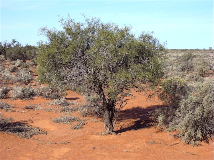
Acacia carneorum habit
Acacia carneorum in Boolcoomatta Bush Heritage Reserve, South Australia, near Broken Hill

Boolcoomatta Reserve history and protected-area timeline

Boolcoomatta was worked as a sheep station for approximately 150 years, operating at times with flocks of up to around 90,000 sheep. Small-scale copper mining also took place on portions of the property at various points during its working history, leaving behind scattered relics across the landscape.

The transition to conservation began in 2006, when Bush Heritage Australia acquired the property with financial assistance from the Australian Government and Nature Foundation SA. The purchase marked the end of intensive pastoral use and the start of a long-term conservation management regime focused on habitat recovery and the protection of native species.

A 2012 wildlife survey, conducted by a team of approximately 50 volunteers, provided an early indication of how the property was responding to its new role. The survey recorded healthy bird populations and reported increasing numbers of marsupials and reptiles, an outcome consistent with the broader recovery expected on former grazing land once livestock are removed and natural processes are allowed to resume.

Boolcoomatta Reserve landscape and geographic character

The terrain of Boolcoomatta is predominantly flat, broken by undulating ranges and rocky outcrops concentrated in the western section of the property. These ranges create varied microhabitats, with shallow stony soils and elevated ground that contrast with the broader plains stretching away to the east.

Where the country rises into the western ranges, the ground is dominated by open Acacia woodland, with hardier tree species suited to the arid conditions. The flatter eastern plains carry extensive shrublands made up largely of chenopods, including saltbush species of the genus Atriplex, as well as open tussock grasslands. Usually dry creek systems cross parts of the reserve, occasionally holding water in scattered waterholes, and these corridors are lined by river red gums, one of the iconic eucalypts of the Australian inland.

The climate is a defining element of the landscape. With an average annual rainfall of only around 190 millimetres, Boolcoomatta lies firmly in Australia's arid zone, and the character of its vistas, vegetation, and wildlife patterns is shaped accordingly. The result is a landscape of subtle but persistent contrasts, where rocky ridges, open plains, and dry creek lines form a mosaic typical of the South Australian outback.

Boolcoomatta Reserve ecosystems, habitats, and plant life

Boolcoomatta's ecological identity is shaped by the interaction of an arid climate with a landscape that shifts between rocky ranges and broad plains. This combination produces a mosaic of vegetation communities typical of the South Australian arid zone, where plant survival is closely tied to soil type, drainage, and subtle changes in elevation.

The western ranges support open Acacia woodland adapted to shallow, stony soils, while the eastern plains are dominated by chenopod shrublands including saltbush, together with patches of tussock grassland. These habitats together cover a substantial proportion of the reserve and represent intact examples of plant communities that have been heavily altered by grazing elsewhere in the region.

Drainage lines, usually dry but occasionally holding water in pools, introduce a different ecological character into the otherwise dry landscape. The river red gums that line these corridors create localised areas of higher productivity, supporting a different suite of plant and animal life and providing important movement corridors for wildlife across the broader property. Seasonal rainfall patterns drive cycles of growth and flowering across the reserve, with chenopod shrubs and grasses responding opportunistically to rain.

Boolcoomatta Reserve wildlife and species highlights

The wildlife of Boolcoomatta reflects the broader arid-zone fauna of eastern South Australia, with a particular emphasis on birds adapted to chenopod shrublands, open grasslands, and rocky range country. The 2012 survey recorded healthy bird populations across these habitats, suggesting that the property supports an ecologically credible slice of the regional avifauna.

Among the most notable species are the thick-billed grasswren and the slender-billed thornbill, both of which are listed as threatened and have established populations on the reserve. These small, ground-dwelling or shrub-loving birds depend on the structural complexity of intact chenopod and grassy habitats, making Boolcoomatta especially important for their long-term conservation. The property also forms part of the Boolcoomatta, Bindarrah and Kalkaroo Stations Important Bird Area, recognised by BirdLife International for supporting a significant population of plains-wanderers, a vulnerable and highly specialised grassland bird.

Beyond birds, surveys have documented increasing numbers of marsupials and reptiles following the reduction of grazing pressure, indicating that the reserve is beginning to fulfil its role as a refuge for native fauna. Habitat on the property is considered suitable for the yellow-footed rock-wallaby, a species known from the adjoining Bimbowrie Conservation Park, suggesting potential for further natural expansion of wildlife populations as the landscape continues to recover.

Boolcoomatta Reserve conservation status and protection priorities

Boolcoomatta's central conservation significance lies in its role as one of the largest privately managed conservation reserves in arid South Australia, and as a place where formerly grazed country is being restored for native wildlife. Its size, its ecological representativeness of the South Australian arid zone, and its long-term secure management make it a regionally important refuge for species that have declined elsewhere under pastoral pressure.

The reserve holds formal recognition through a perpetual conservation covenant, which places it within Australia's National Reserve System and gives it IUCN Category II status, equivalent to a national park in terms of protection level. This formal status secures the property's conservation values in perpetuity and links Boolcoomatta into the national network of protected areas.

Its inclusion in the Boolcoomatta, Bindarrah and Kalkaroo Stations Important Bird Area adds an international dimension to its conservation profile, particularly because of the significance assigned to populations of plains-wanderers and other threatened grassland-dependent birds. Together these factors position Boolcoomatta as an important example of how large-scale private conservation, combined with public funding and partnerships, can contribute to biodiversity outcomes in arid Australia.

Boolcoomatta Reserve cultural meaning and human context

Boolcoomatta's cultural context is closely tied to its long pastoral history and its location within the broader pastoral landscape of eastern South Australia. For 150 years the land supported a major sheep station, at times carrying flocks of around 90,000 sheep, and small-scale copper mining also left physical traces across parts of the property in the form of mining relics.

The reserve sits within a sparsely populated region where pastoralism, mining, and conservation now exist side by side. Its proximity to Olary, one of the small historic settlements of the South Australian outback, and its position along the corridor between Adelaide and Broken Hill place it within a wider cultural geography of remote inland Australia. Today the property's pastoral heritage is preserved as part of its history, while its working role has shifted decisively toward conservation and ecological recovery.

Top sights and standout views in Boolcoomatta Reserve

Among Boolcoomatta's standout features is its sheer scale as a private conservation property in arid South Australia, offering a substantial intact example of outback landscapes, from rocky Acacia-clad ranges to saltbush plains and tussock grasslands. Its dry creek corridors, lined with river red gums and occasionally holding waterholes, provide localised pockets of higher productivity within the otherwise arid environment.

The reserve is particularly notable for its significance to bird conservation, hosting threatened species such as the thick-billed grasswren and slender-billed thornbill, and forming part of an Important Bird Area recognised for the vulnerable plains-wanderer. Its perpetual covenant within Australia's National Reserve System and its IUCN Category II status underline both the long-term security of the property and the seriousness with which its conservation values are recognised at a national level.

Best time to visit Boolcoomatta Reserve

Boolcoomatta's character shifts with the seasons in ways that are typical of the South Australian arid zone. Cooler months in the southern autumn, winter, and early spring tend to bring milder daytime temperatures, more reliable opportunities to observe wildlife, and the prospect of greener conditions following rainfall. Summer in this part of outback South Australia is typically hot and dry, with high daytime temperatures and limited surface water, which can make outdoor activity more demanding.

Periods following significant rainfall can transform the appearance of the reserve, with chenopod shrublands, saltbush, and tussock grasslands responding with growth and flowering. Such times can also coincide with more visible bird and reptile activity. For visitors interested in seeing the reserve's birdlife at its most active, cooler months and seasons following rain tend to offer the most rewarding conditions, while always keeping in mind the remote location and the need to be self-sufficient in such an arid environment.
Monthly climate preview

Long-term monthly temperature and precipitation rhythm across South Australia

Boolcoomatta Reserve Climate Normals and Annual Temperature Patterns

Boolcoomatta Reserve exhibits a measured annual cycle of monthly temperatures and low precipitation based on recorded coordinate normals. Analyzing the full twelve-month climatology profile reveals complete seasonal temperature swings and multi-year precipitation trends.
Annual mean19 °C
10 °C28 °C
Jan28°
Feb27°
Mar23°
Apr19°
May14°
Jun10°
Jul10°
Aug11°
Sep15°
Oct19°
Nov23°
Dec26°
Warmest month
January

27.9 °C

Coolest month
July

9.7 °C

Wettest month
February

1 mm/day

Driest month
August

0.4 mm/day

Park location guide

Geography guide, regional context, and park location map for Boolcoomatta Reserve

Boolcoomatta Reserve park geography, regions, and map view in Australia

Understand where Boolcoomatta Reserve sits in Australia through a broader geographic reading of the surrounding landscape, nearby location context, and its mapped position within the national park landscape.

How Boolcoomatta Reserve fits into Australia

Australia is a constitutional monarchy and federal parliamentary democracy comprising six states and ten territories. With a population of nearly 28 million, it is one of the world's most urbanised countries, with most people concentrated on the eastern seaboard. The country has a high Human Development Index and is known for its cultural diversity, ancient Aboriginal heritage, and unique wildlife.

Wider geography shaping Boolcoomatta Reserve in Australia

Australia occupies the entire Australian continent, the island of Tasmania, and numerous smaller islands. It is the world's flattest and driest inhabited continent, featuring vast deserts in the interior (the Outback), tropical rainforests along the eastern coast, and a coastline bordering the Indian and Pacific Oceans.

Map view of Boolcoomatta Reserve

Use this park location map to pinpoint Boolcoomatta Reserve in Australia, understand its exact geographic position, and read its mapped placement within the surrounding landscape more clearly.

Pigeon | © OpenStreetMap contributors

Location context for Boolcoomatta Reserve

South Australia

Visual reference of arid terrain, chenopod shrublands, and protected outback habitats

Boolcoomatta Reserve Photos and Landscape Scenery in South Australia

Visual documentation captures the distinct terrain, arid vegetation mosaics, and protected habitats across Boolcoomatta Reserve. Photographic collections illustrate remote outback scenery, rocky ranges, and dry creek corridors that define the conservation landscape.

Acacia carneorum habit

Park atlas

Compare regional conservation areas and outback reserves across South Australia

Parks Near Boolcoomatta Reserve and Surrounding Arid Protected Landscapes

Browse protected areas and regional conservation reserves situated near Boolcoomatta Reserve in the South Australian outback. Comparing adjacent arid terrain and native wildlife habitats provides deeper geographic context for regional wilderness exploration.
Nature reserveNew South Wales
About 132 km away#1 closest

South

Scotia Sanctuary: Protected Nature Reserve and Mallee Landscape Geography in New South Wales

Arid zone conservation and dune-swale mapping.

Scotia Sanctuary serves as a primary example of arid-zone conservation in south-western New South Wales. This reserve protects vast tracts of intact eucalypt mallee shrubland and sheoak woodland, set across a distinctive landscape of parallel sand dunes and calcareous swales. Its geographic position within the Murray-Darling Depression makes it a critical site for understanding the intersection of land management, habitat restoration, and regional ecological patterns.

Area
650 km²
Established
1994
Relief
Lowland
Climate
Arid
National parkSouth Australia
About 153 km away#2 closest

Northwest

Lake Frome National Park: Mapped Protected Area and Regional Geographic Identity in South Australia

Explore South Australia's unique landscape and park boundaries.

Lake Frome National Park offers a distinct focus for exploring the geography and protected landscape of South Australia. As a national park, it contributes to the mapped conservation network of the region, allowing for detailed study of its environmental context and geographic positioning. Discover the mapped terrain and regional park boundaries that define this significant protected area, crucial for a comprehensive atlas-based understanding of South Australia's natural heritage.

Area
2,582.4 km²
Established
1991
IUCN
VI
Relief
Lowland
Biosphere reserveSouth Australia
About 154 km away#3 closest

South

Riverland Biosphere Reserve: Geography and Protected Landscapes in South Australia

Mapping the convergence of mallee woodland and riverine wetland ecosystems

Riverland Biosphere Reserve represents a significant landscape-scale conservation effort covering 9,000 square kilometres of South Australian terrain. The reserve encompasses an ecological mosaic, where arid, sandy mallee woodlands transition into a complex network of Murray River floodplains and riparian wetlands. This overview maps the protected area structure, highlighting the unique environmental interplay that supports essential bird populations and ecologically sustainable development.

Area
9,000 km²
Established
1977
Relief
Lowland
Climate
Arid
National parkNew South Wales
About 156 km away#4 closest

Southeast

Kinchega National Park: National Park Protected Area in New South Wales

Explore the mapped Darling River terrain and outback landscapes.

Kinchega National Park stands as a protected national park entity within New South Wales, Australia. Its geographic significance is deeply tied to the Darling River, which shapes its unique riparian ecosystems and contrasts with the surrounding semi-arid outback terrain. This park offers a valuable point for atlas-based discovery, allowing exploration of its mapped boundaries, landscape context, and the conservation of its distinct natural and cultural heritage within the regional geography.

Area
442.59 km²
Established
1967
IUCN
II
Climate
Arid
National parkNew South Wales
About 169 km away#5 closest

Northeast

Mutawintji National Park: New South Wales Protected Area for Atlas Exploration

Mapping rugged outback terrain, gorges, and ancient rock art.

Mutawintji National Park in New South Wales offers a profound exploration of Australia's outback geography, significant Indigenous heritage, and protected landscapes. Discover the park's unique terrain, defined by the Byngnano Range, vibrant gorges, and river red gum-lined creeks, all rich with ancient Aboriginal rock art. This national park is a prime example of mapped protected area discovery, highlighting both natural beauty and critical conservation achievements.

Area
689.12 km²
Established
1998
IUCN
II
Relief
Mountain
National parkSouth Australia
About 169 km away#6 closest

Northwest

Vulkathunha-Gammon Ranges National Park: South Australia National Park Atlas Exploration

Mapped boundaries and regional geographic context.

Dive into the specifics of Vulkathunha-Gammon Ranges National Park, a designated national park situated in South Australia. This detailed resource focuses on its role as a protected landscape, providing users with critical geographic information. Understand the park's mapped boundaries and its relation to the broader regional geography, perfect for anyone engaged in atlas-based exploration of Australia's natural areas.

Area
1,257.23 km²
Established
1970
IUCN
II
Relief
Mountain
Nature reserveSouth Australia
About 177 km away#7 closest

South

Danggali Conservation Park: Semi-Arid Protected Land and Murray-Mallee Geography

Nature reserve geography and inland landscape context in South Australia.

Danggali Conservation Park preserves a substantial inland landscape north of the Riverland, characterised by open mallee scrubland, sandy dune systems, and dry eucalypt woodlands. This protected area acts as a crucial ecological bridge, showcasing the distinct shift from river-influenced environments to the arid interior of South Australia.

Area
484.16 km²
Established
1976
IUCN
Ia
Relief
Upland
National parkAustralia
About 188 km away#8 closest

West

Ikara-Flinders Ranges National Park: Mapped Boundaries and Regional Geography

Australia's protected landscape and national park terrain.

Investigate the geographic characteristics and protected-area identity of Ikara-Flinders Ranges National Park. This entry highlights its mapped boundaries and landscape context, offering a foundational understanding of this Australian national park for atlas-based discovery. Users can explore the natural terrain and regional setting that define Ikara-Flinders Ranges National Park.

Common questions about visiting, size, designation, and location context for Boolcoomatta Reserve

Boolcoomatta Reserve FAQs for park facts, access, geography, and protected area context

Find quick answers about Boolcoomatta Reserve, including protected-area facts, park geography, trail and visitor context, and how the park fits into its surrounding country and regional landscape.
MoriAtlas Explorer

Continue Your Protected Areas Search Across the Global Atlas

Deepen your exploration by continuing the structured search for national parks and protected areas worldwide. Utilize the comprehensive filtering capabilities to compare different conservation landscapes and refine your understanding of global park geography. Discover more about the distribution and characteristics of protected natural areas.

Global natural geography