

Mori Atlas logo
National parkBoorabbin National Park

Discover the mapped protected area boundaries and natural terrain of this Western Australia national park.

Boorabbin National Park: Western Australia's Protected Landscape and Geographic Identity

Boorabbin National Park stands as a significant protected area within Western Australia, offering a unique lens for exploring mapped natural landscapes and regional geography. As a designated national park, it provides essential context for understanding the distribution and geographic identity of conservation lands across this vast Australian state. Users can delve into the park's specific protected boundaries and its place within the broader atlas of Western Australia's diverse terrain.

Australian national parksSand plateau ecosystemsKwongan heathWestern AustraliaEastern goldfieldsProtected areas

Boorabbin National Park

National park

Park overview

Structured park overview, official facts, and landscape profile for Boorabbin National Park

Boorabbin National Park park facts, protected area profile, and essential visitor context
Review the core facts for Boorabbin National Park, including designation, size, terrain, visitor scale, habitats, and operating context in one park-focused overview.

About Boorabbin National Park

Boorabbin National Park occupies a significant position in Western Australia's protected area network as a representative example of the ancient sand plateau ecosystems of the eastern goldfields. The park's location along the Great Eastern Highway makes it accessible to travellers crossing the goldfields region, while its natural values distinguish it from the more typical mallee and wheatbelt landscapes encountered in nearby areas. The park protects an extensive plateau system with deep sand deposits that have been weathered and leached over tens of millions of years, resulting in extremely nutrient-poor soils that nonetheless support remarkably diverse plant communities. The vegetation ranges from dense kwongan heaths on the deeper sands to woodland and mallee shrubland communities, with the entire plateau recognised as a distinct vegetation system. This environmental character, combined with the park's historical association with the Boorabbin settlement and the 2007 bushfire tragedy, gives the area both ecological and cultural significance.

Quick facts and research context for Boorabbin National Park

Boorabbin National Park covers 281.53 square kilometres in Western Australia's eastern goldfields region. The park was established in 1977 and is managed by the Department of Environment and Conservation. It lies along the Great Eastern Highway, stretching approximately 25 kilometres with a width of 5 kilometres on each side. The landscape is characterised by an ancient sand plateau with deposits dating back over 50 million years. The park is named after the Aboriginal word for a rock formation at the park's edge and the historic Boorabbin settlement founded in 1898. Notable vegetation includes kwongan heaths, mallee shrublands, and numerous endemic plant species.

Park context

Deeper park guide and search-rich context for Boorabbin National Park

Boorabbin National Park history, landscape, wildlife, and travel context
Explore Boorabbin National Park through its history, landscape character, ecosystems, wildlife, conservation priorities, cultural context, and seasonal travel timing in a structured park guide built for atlas discovery and search intent.

Why Boorabbin National Park stands out

Boorabbin National Park is best known for its unique sand plateau landscape, one of the oldest and most distinctive landforms in Western Australia's wheatbelt and goldfields region. The park preserves extensive kwongan heath communities, a vegetation type characterised by extraordinary species diversity despite growing in heavily leached, nutrient-poor sands. The plateau supports two restricted plant species, Philotheca pachyphylla and Philotheca coccinea, found only in this area. The park is also noted for its wildflower displays, the presence of samphire communities around salt lakes, and the dramatic contrast between the sandy plateau and the surrounding semi-arid terrain.

Boorabbin National Park history and protected-area timeline

Boorabbin National Park was established in 1977, formalising protection for the distinctive sand plateau landscape in Western Australia's eastern goldfields. The park takes its name from the Aboriginal rock formation at the park's edge and the historic Boorabbin settlement, which was founded in 1898 during the gold rush era that transformed the region. The settlement served as a temporary mining camp and railway staging point before eventually being abandoned. In December 2007, a major bushfire swept through the park, tragically resulting in the deaths of three truck drivers who became trapped while attempting to escape along the Great Eastern Highway. The fire burnt more than 7,500 hectares of the park and surrounding crown land before being contained after two weeks. A coronial inquiry later found that extreme incompetence by the Department of Environment and Conservation had contributed to the deaths. A memorial garden and shelter was established near the old town site in 2010 to honour those who lost their lives.

Boorabbin National Park landscape and geographic character

The landscape of Boorabbin National Park is dominated by a prominent sand plateau that rises above the surrounding semi-arid goldfields terrain. The plateau is characterised by deep sand deposits that were laid down over 50 million years ago during a period of geological stability. These sands have subsequently undergone extensive weathering and leaching, removing nutrients and creating the acidic, infertile conditions that define the current environment. The erosion that shaped this distinctive landform continues today, though at a reduced rate compared to historical periods when the landscape experienced greater degradation. The park's sand sheet terrain supports characteristic vegetation communities that are specifically adapted to these challenging conditions, with the plateau maintaining its own designated vegetation system recognised for its ecological uniqueness.

Boorabbin National Park ecosystems, habitats, and plant life

The ecological character of Boorabbin National Park is defined by its ancient sand plateau and the specialised plant communities that have evolved to thrive in its nutrient-poor environment. The park supports three primary vegetation types: kwongan heaths, woodlands and mallee shrublands, each adapted to different depths and conditions of the sandy substrate. Kwongan heath represents the most diverse community, characterised by dense, low shrubs and extraordinary plant species richness. The park also contains samphire communities around salt lakes and distinctive grasstrees. The vegetation includes numerous species of banksia, acacia, hakea, sandalwood, melaleuca and grasstree. Two restricted endemic species, Philotheca pachyphylla and Philotheca coccinea, occur only within the heathland of this plateau system.

Boorabbin National Park wildlife and species highlights

Fauna surveys conducted within Boorabbin National Park have documented a diverse mammalian fauna comprising seventeen native species. These include small marsupials such as the wongai ningaui, various dunnart species and bush rats. The reptile fauna is particularly rich, with fifty-two species recorded within the park, including a diverse array of dragon lizards. The park also supports fifty-one bird species and four amphibian species, representing a notable diversity for this semi-arid region. This collection of fauna, combined with the specialised plant communities, demonstrates the ecological significance of the sand plateau habitat.

Boorabbin National Park conservation status and protection priorities

Boorabbin National Park plays an important role in conserving the unique sand plateau ecosystems of Western Australia's eastern goldfields. The park protects the only designated plateau vegetation system in the region, preserving plant communities that have adapted to ancient, nutrient-poor sands over millions of years. The presence of restricted endemic species, including Philotheca pachyphylla and Philotheca coccinea, adds particular conservation significance to the area. The diverse fauna assemblages, including seventeen mammal species and over fifty reptile species, further demonstrate the ecological value of protecting this landscape.

Boorabbin National Park cultural meaning and human context

The park's name derives from Aboriginal heritage, specifically from a rock formation at the park's edge that held significance in local indigenous culture. The area is also connected to the historic Boorabbin settlement, a short-lived mining and railway camp established in 1898 during the gold rush period that transformed the Eastern Goldfields region. The tragic 2007 bushfire and its aftermath have added a contemporary layer to the site's cultural memory, with the memorial garden and shelter providing a place of commemoration for those who died in the event.

Top sights and standout views in Boorabbin National Park

The ancient sand plateau with deposits exceeding 50 million years represents one of the park's most significant geological features, offering a window into the long environmental history of the Western Australian landscape. The kwongan heath communities support exceptional plant diversity in an environment few would expect to be productive. The park provides habitat for seventeen native mammal species, fifty-two reptile species and fifty-one bird species. The 2007 bushfire memorial honours both the natural landscape and those who perished in one of the region's more recent historical events.

Best time to visit Boorabbin National Park

The cooler months from late autumn through winter into early spring, roughly May through September, offer the most comfortable conditions for exploring Boorabbin National Park. During this period, temperatures are moderate and wildflower displays may appear following seasonal rains. The summer months can bring extreme heat and the risk of bushfires, as demonstrated by the significant 2007 fire event. Spring often brings flowering to the kwongan heaths and mallee communities, though conditions can vary significantly from year to year depending on rainfall patterns.
Park location guide

Geography guide, regional context, and park location map for Boorabbin National Park

Boorabbin National Park park geography, regions, and map view in Australia
Understand where Boorabbin National Park sits in Australia through a broader geographic reading of the surrounding landscape, nearby location context, and its mapped position within the national park landscape.

How Boorabbin National Park fits into Australia

Australia is a constitutional monarchy and federal parliamentary democracy comprising six states and ten territories. With a population of nearly 28 million, it is one of the world's most urbanised countries, with most people concentrated on the eastern seaboard. The country has a high Human Development Index and is known for its cultural diversity, ancient Aboriginal heritage, and unique wildlife.

Wider geography shaping Boorabbin National Park in Australia

Australia occupies the entire Australian continent, the island of Tasmania, and numerous smaller islands. It is the world's flattest and driest inhabited continent, featuring vast deserts in the interior (the Outback), tropical rainforests along the eastern coast, and a coastline bordering the Indian and Pacific Oceans.

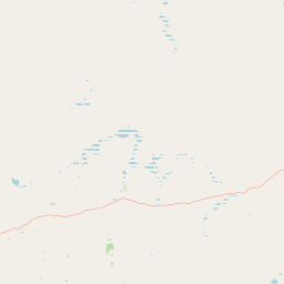
Map view of Boorabbin National Park

Use this park location map to pinpoint Boorabbin National Park in Australia, understand its exact geographic position, and read its mapped placement within the surrounding landscape more clearly.

Pigeon | © OpenStreetMap contributors

Location context for Boorabbin National Park

Western Australia
Park atlas

Compare diverse protected landscapes and park geography across Western Australia's Eastern Goldfields region.

Discover National Parks and Protected Areas Near Boorabbin National Park, Western Australia
Continue your geographic exploration from Boorabbin National Park by browsing other national parks and protected areas across Western Australia's Eastern Goldfields region. Compare diverse protected landscapes, mapped terrain, and distinct ecological zones, tracing the regional spread of kwongan heath communities and ancient sand plateau environments.
National parkGoldfields-Esperance

Goldfields Woodlands National Park: Explore Protected Area Geography and Mapped Boundaries

Discover the mapped landscape context of this national park.

Delve into Goldfields Woodlands National Park, a key protected area within the Goldfields-Esperance region. This resource provides detailed atlas-style information, focusing on the park's mapped geography, its protected status, and its role within the broader regional landscape. Understand its specific topographic features and its place in the natural atlas.

Area
646.28 km²
Established
2000
Climate
Arid
Scope
Terrestrial
National parkWestern Australia

Frank Hann National Park: Explore Its Protected Area Geography and Mapped Boundaries

Western Australia's protected national park landscape.

Frank Hann National Park is a designated national park providing crucial insight into Western Australia's protected natural landscapes. This entry focuses on its precise geographic scope and mapped boundaries, allowing for detailed atlas-based exploration. Understand the park's identity as a protected area and its position within the broader regional geography of this large Australian state, ideal for focused landscape discovery.

Area
675.5 km²
Established
1970
IUCN
II
Relief
Lowland
National parkWestern Australia

Goongarrie National Park: A Mapped Protected Landscape in Western Australia

Explore regional geography and park boundaries.

Goongarrie National Park represents a distinct protected landscape within the extensive geography of Western Australia. This page offers detailed atlas-style information, focusing on its mapped boundaries and its place as a national park within the region's conservation network. Understand the geographic context of Goongarrie National Park and its contribution to the mapped protected areas of Australia.

Area
603.97 km²
Established
1978
IUCN
II
Climate
Arid
National parkWestern Australia

Peak Charles National Park: A National Park in Western Australia's Mapped Landscape

Discover its protected area status and geographic setting.

Peak Charles National Park is a vital component of Western Australia's protected natural areas. This dedicated page provides an atlas-centric view, focusing on the park's geographic scope, its mapped boundaries, and the surrounding regional landscape context. It serves as an essential resource for understanding the park's protected land identity and its contribution to the broader geography of Western Australia.

Area
399.59 km²
Established
1979
IUCN
II
Relief
Mountain
National parkWestern Australia

Stokes National Park National Park: Mapped Boundaries and Regional Geography

Western Australia's protected landscape identity.

Stokes National Park represents a significant protected entity within the expansive geography of Western Australia. This detailed page provides users with essential mapping information, focusing on the park's designated boundaries and its role within the broader atlas of Australian conservation landscapes. Explore the specific geographic context that defines this national park and understand its natural landscape features.

Area
97.26 km²
Established
1976
IUCN
II
Relief
Lowland
Watercolor illustration showing mountains in the background, green vegetation, and pink meadows
National parkWestern Australia

Fitzgerald River National Park: A Western Australian Protected Landscape of Global Botanical Importance

Discover its mapped terrain, endemic flora, and UNESCO Biosphere Reserve status.

Fitzgerald River National Park stands as a protected landscape of immense ecological value in Western Australia. This national park is celebrated for its extraordinary botanical diversity, featuring more endemic plant species than any other conservation reserve in Australia. Its varied terrain, from rugged mountain ranges to coastal cliffs, provides a rich tapestry of natural habitats. As a designated UNESCO Biosphere Reserve, it offers a unique opportunity to explore mapped geographic features and understand the critical role of protected areas in conserving rare flora and distinct Mediterranean ecosystems.

Area
2,972.11 km²
Established
1973
IUCN
II
Visitors
40K annual
National parkAustralia

Dryandra Woodland National Park: Australia National Park Atlas and Protected Landscape

Explore its mapped boundaries and natural terrain.

Dryandra Woodland National Park stands as a protected area within Australia, designated as a national park. This page provides a detailed look at its geographic setting, mapped landscape features, and its role in the country's protected lands. Understand the protected boundaries and natural terrain that characterize this important conservation site, contributing to a comprehensive view of Australia's natural atlas.

Area
280.66 km²
Established
2022
Visitors
30K annual
Relief
Upland
National parkWestern Australia

Cape Le Grand National Park: Western Australia National Park Geographic Context and Landscape Exploration

Mapped protected area boundaries and regional natural terrain discovery.

Cape Le Grand National Park is an important national park in Western Australia, providing a distinct focus for geographic and atlas-based discovery. Understanding its protected landscape identity and its placement within the state's natural geography offers valuable insight into regional conservation areas. This page serves as a canonical entry point for exploring the mapped features and the broader geographic significance of Cape Le Grand National Park, detailed for structured atlas exploration.

Area
318.01 km²
Established
1966
IUCN
II
Relief
Mixed relief

Common questions about visiting, size, designation, and location context for Boorabbin National Park

Boorabbin National Park FAQs for park facts, access, geography, and protected area context
Find quick answers about Boorabbin National Park, including protected-area facts, park geography, trail and visitor context, and how the park fits into its surrounding country and regional landscape.
MoriAtlas Explorer

Continue Your Protected Areas Search Across the Global Atlas

Deepen your exploration by continuing the structured search for national parks and protected areas worldwide. Utilize the comprehensive filtering capabilities to compare different conservation landscapes and refine your understanding of global park geography. Discover more about the distribution and characteristics of protected natural areas.

Global natural geography