
Mori Atlas logo
Nature reserveBorkeld

A diverse mosaic of heathland, juniper shrubland, and archaeological terrain in the eastern Netherlands

Borkeld Nature Reserve in Overijssel: Mapped Protected Landscapes and Regional Geography

(De Borkeld)

The Borkeld nature reserve spans approximately 600 hectares within the province of Overijssel, forming a critical ecological link on the edge of the Salland ridge. This protected area features a complex mosaic of dry and wet heath, production forests, and rare raised bog fragments. Mapped terrain includes distinctive historic clay pits and an extensive archaeological layer of prehistoric burial mounds, reflecting centuries of human interaction with this varied Dutch landscape.

heathlandjuniper shrublandproduction forestraised bogclay pitsNatura 2000
A flat-style digital illustration depicting a winding river leading toward a waterfall between two high rock cliffs, surrounded by pine trees and soft clouds.

Borkeld

Nature reserve

Park overview

Structured park overview, official facts, and landscape profile for De Borkeld

De Borkeld park facts, protected area profile, and essential visitor context

Review the core facts for De Borkeld, including designation, size, terrain, visitor scale, habitats, and operating context in one park-focused overview.

About De Borkeld

De Borkeld is a protected natural area in the province of Overijssel, in the eastern part of the Netherlands. It sits in the municipality of Rijssen-Holten, occupying a gently undulating stretch of land between the towns of Markelo, Holten and Rijssen. Although the area shares its name with a nearby historic buurtschap, the buurtschap and the nature area are now separated by the A1 motorway.

Ecologically, the Borkeld is a mosaic landscape. Large parts of the area are covered by production forests that were planted between roughly 1930 and 1950, but the open elements are equally important. Both dry and wet heathland occur, along with patches of raised bog, agricultural fields and grasslands, and a series of deep clay pits called leemkuilen. These pits are now ecologically valuable in their own right, because the unusual conditions within them have produced a distinctive plant community.

One of the most prominent features of the Borkeld is the large juniper shrubland, which is the most extensive juniverbesstruweel in the Netherlands. Juniper shrublands of this type have become rare in the country, mainly because of changes in land use, nitrogen deposition and the loss of traditional grazing practices. Protecting this juniper stand has, in turn, shaped the wider landscape management of the Borkeld, including how the main infrastructure in the region was planned.

The area is also an archaeological reserve, with records of human activity reaching back to the late Mesolithic, around 13,000 years ago. Traces of prehistoric hunter-gatherers, including stone axes and hide scrapers, have been recovered, and prehistoric burial mounds and settlement remains dating from between roughly 6,000 and 4,000 years ago have been investigated. In 1997, a number of burial mounds were restored by the former Dutch National Service for Archaeological Research. The historic landweer, a low defensive earthwork, also runs through the Borkeld, adding another layer of cultural landscape to the area.

Quick facts and research context for De Borkeld

De Borkeld lies in the province of Overijssel in the eastern Netherlands, within the municipality of Rijssen-Holten, and stretches between the towns of Markelo, Holten and Rijssen. It is managed by Staatsbosbeheer and was registered as a Natura 2000 area under number 44 in the Dutch network of European protected sites.

The terrain combines planted forest, wet and dry heath, raised bog remnants, fields, meadows and deep clay pits. It contains the largest juniper shrubland in the Netherlands and is crossed by the historic landweer defensive line. Its highest point, the Friezenberg, reaches about 40 metres above sea level, while the lowest parts sit around 13 metres.

Protection and recognition

Examine the terrestrial protection scope and documented designation records for Borkeld.

Borkeld Protection Status and International Recognition Overview

Terrestrial protection records for Borkeld outline the established conservation boundaries and management scope for the landscape. Structured designation data details the official status and international recognition sources associated with the protected area.

Protection details

Protection scope
Terrestrial
Transboundary protection
No
Park context

Deeper park guide and search-rich context for De Borkeld

De Borkeld history, landscape, wildlife, and travel context

Explore De Borkeld through its history, landscape character, ecosystems, wildlife, conservation priorities, cultural context, and seasonal travel timing in a structured park guide built for atlas discovery and search intent.

Why De Borkeld stands out

De Borkeld is best known for holding the largest juniper shrubland in the Netherlands, a mosaic of heath, young woodland and bog fragments, and an unusually rich prehistoric archaeological record. The contrast between human-shaped features, including production forests and clay pits, and the surviving semi-natural heath habitats gives the area a distinctive ecological character. The site also stands out in conservation terms because the motorway A1, which crosses the region, was deliberately routed in a curve around the juniper field to protect it, and one of the early Dutch wildlife crossings was later built at this same point.
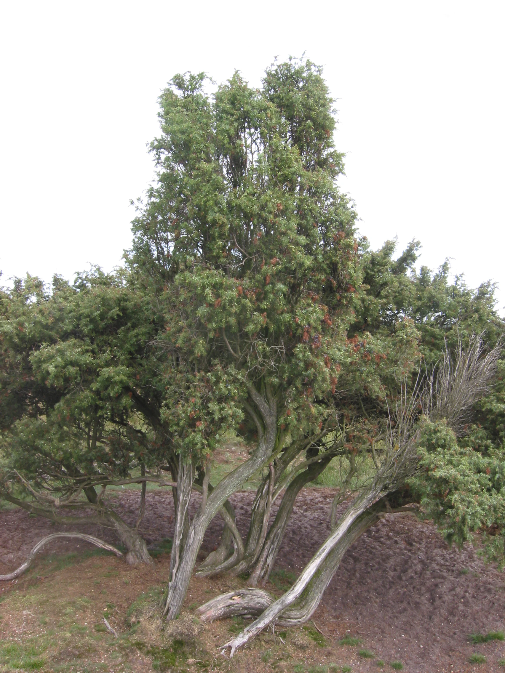
A mature common juniper bush with twisting, gnarled grey trunks and dense, needle-like green foliage.
A mature common juniper shrub, a characteristic species of the Borkeld heathlands.

De Borkeld history and protected-area timeline

The Borkeld has been recognised as a coherent area since at least the eighteenth century, when it was already mentioned together with the neighbouring locality of Look. Industrial activity in the area goes back to this same period: there was already a tile works in the eighteenth century, using local loam to produce bricks and roof tiles that were traded across the Twente region.

In the twentieth century, large parts of the Borkeld were afforested, with the production forests established between approximately 1930 and 1950. The construction of the A1 motorway in the 1970s cut the area into two parts and brought new pressures, but conservation groups successfully argued that the route should be diverted south of Rijssen to spare the important juniper field. In 2003, an eco-bridge was built over the motorway at this same location, providing a crossing for wildlife and a parallel trail for walkers and cyclists.

Recognition of the area's archaeological value led to formal protection as an archaeological reserve, and in 1997 a number of prehistoric burial mounds were restored by the former Rijksdienst voor het Oudheidkundig Bodemonderzoek.

De Borkeld landscape and geographic character

The terrain of De Borkeld is gently undulating rather than dramatic. The highest point, the Friezenberg, rises to about 40 metres above sea level, while parts of the area drop to around 13 metres, producing a varied topography for an inland Dutch nature area of this scale.

The landscape is a patchwork of open and wooded elements. Planted production forests cover significant portions, but they alternate with open stretches of dry heath on the drier slopes and wet heath in the lower, damper zones. Small remnants of raised bog add an additional element of peatland character. The historic landweer, a low defensive earthwork, runs through the area, creating subtle linear features in the relief. The clay pits, some of them five metres or more in depth, introduce unusual vertical contrast into an otherwise low-relief terrain.
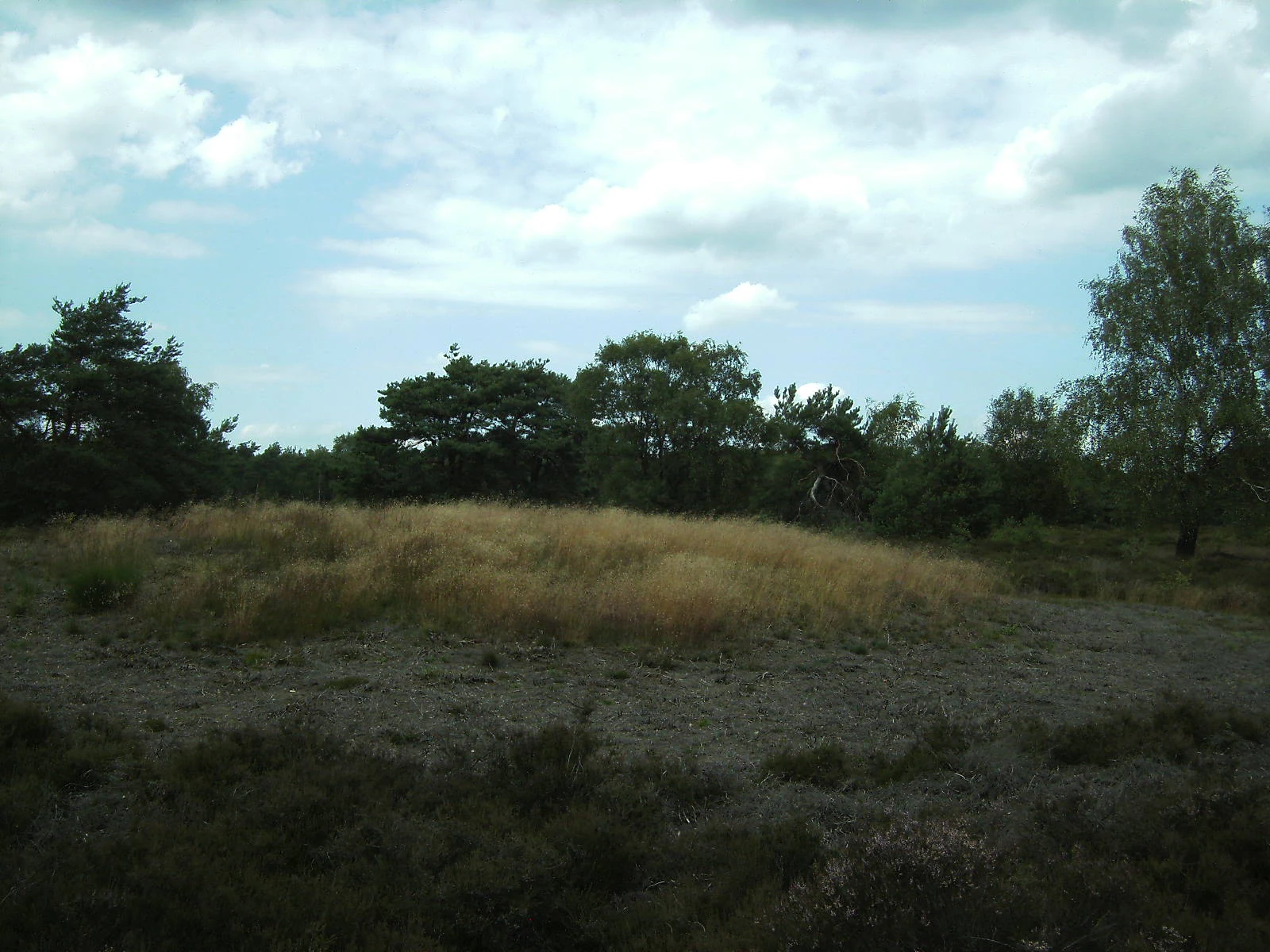
A low, grassy earthen mound sitting in a clearing surrounded by shrubs and trees under a cloudy sky.
A prehistoric burial mound located within the heathland landscape of Borkeld.

De Borkeld ecosystems, habitats, and plant life

Ecologically, De Borkeld is shaped by the interaction between coniferous production forest and the surviving open habitats. The heathlands include both dry heath dominated by heather species on drier sandy soils and wet heath in the moister hollows, while the raised bog fragments support their own specialised peatland vegetation.

The most ecologically distinctive element is the large juniper shrubland. The Borkeld holds the most extensive juniper struweel in the Netherlands, an increasingly rare habitat type shaped by grazing, soil conditions and historical land use. The deep clay pits further add to this habitat diversity, because the specific hydrological and substrate conditions inside them support a plant community that differs from the surrounding heath and woodland.

The combination of forest, heath, bog remnants, fields and clay pits gives the area a complex ecological structure, with relatively short distances between very different habitat types. This mosaic is an important reason for the area's designation as a Natura 2000 site.

De Borkeld conservation status and protection priorities

De Borkeld has been formally recognised as part of the Dutch Natura 2000 network, registered under site number 44. This status reflects the area's importance for the conservation of heathland, juniper habitats and related ecological features that have become scarce at both national and European levels. The site is managed by Staatsbosbeheer, the Dutch national forest and nature service.

A notable chapter in the area's conservation history is the protection of the juniper shrubland from infrastructure development. When the A1 motorway was built through the region in the 1970s, conservationists succeeded in having the road routed in a curve around the juniper field to avoid damage to this habitat. In 2003, an eco-bridge with a parallel pedestrian and cycle crossing was constructed at the same location, making the Borkeld one of the earlier Dutch sites where ecological connectivity across a motorway was addressed in a deliberate, structured way.

De Borkeld cultural meaning and human context

The Borkeld combines a natural landscape with a long history of human use. The clay pits that punctuate the area are the visible legacy of an eighteenth-century tile works that produced building materials for the surrounding Twente region, while the historic landweer, an old defensive earthwork, runs through the terrain and adds a layer of regional military and political history.

The area's prehistoric record is particularly rich for a Dutch inland site. Stone tools and other traces show that hunter-gatherers were active here roughly 13,000 years ago, while later prehistoric burial mounds and settlement remains dating from between roughly 6,000 and 4,000 years ago demonstrate prolonged human occupation of the same landscape. The restoration of ten burial mounds in 1997 by the former Dutch National Service for Archaeological Research reflects a continuing effort to preserve this archaeological heritage as part of the area's broader cultural value.

Top sights and standout views in De Borkeld

De Borkeld combines in a relatively compact area the largest juniper shrubland in the Netherlands, a varied mosaic of forest, heath and raised bog, deep historical clay pits with their own specialised plant communities, and a major prehistoric archaeological reserve with restored burial mounds. Its location between Markelo, Holten and Rijssen makes it an important green anchor in the landscape of the eastern Salland region, and the eco-bridge over the A1 motorway marks it as an early example of ecological infrastructure in the Netherlands.

Best time to visit De Borkeld

De Borkeld can be enjoyed year round, but the open character of the heath and juniper shrubland is most striking in late summer and early autumn, when heather is in bloom and juniper berries become a visible part of the landscape. Spring and early summer are good for birdlife and flowering plants in and around the clay pits, while autumn brings clear views across the open heath and quiet conditions for walking and cycling. Winter visits offer an open, airy atmosphere with good visibility across the gently rolling terrain. Visitors wishing to follow the marked walking and cycling routes will find conditions easiest in daylight and in moderately dry weather, as some of the tracks cross wet heath and boggy sections.

Monthly climate preview

Long term average temperature and precipitation rhythm across twelve recorded intervals

Borkeld Climate Normals and Measured Monthly Weather Patterns

Representative coordinate records show average temperatures moving from sub zero winter minimums to warmer summer peaks alongside steady precipitation rates. Reviewing the complete monthly climate profile reveals detailed thermal ranges and multi year meteorological trends for this protected terrain.
Annual mean10 °C
2 °C18 °C
Jan
Feb
Mar
Apr
May13°
Jun16°
Jul18°
Aug18°
Sep15°
Oct10°
Nov
Dec
Warmest month
July

18 °C

Coolest month
January

2 °C

Wettest month
December

2.5 mm/day

Driest month
April

1.4 mm/day

Park location guide

Geography guide, regional context, and park location map for De Borkeld

De Borkeld park geography, regions, and map view in Netherlands

Understand where De Borkeld sits in Netherlands through a broader geographic reading of the surrounding landscape, nearby location context, and its mapped position within the national park landscape.

How De Borkeld fits into Netherlands

The Netherlands is a low-lying coastal country in Northwestern Europe, famous for its extensive dike and canal systems that reclaim land from the sea. It consists of twelve provinces and is known for tulips, windmills, and cycling culture. The country is a founding member of the European Union with Amsterdam as its capital and The Hague as the seat of government.

Wider geography shaping De Borkeld in Netherlands

The Netherlands is located in Northwestern Europe along the North Sea coastline to the north and west. It borders Germany to the east and Belgium to the south. The country is notably flat, with a significant portion of its territory lying below sea level, protected by dikes and dune systems. It consists of twelve provinces and also includes overseas municipalities in the Caribbean.

Map view of De Borkeld

Use this park location map to pinpoint De Borkeld in Netherlands, understand its exact geographic position, and read its mapped placement within the surrounding landscape more clearly.

Pigeon | © OpenStreetMap contributors

Location context for De Borkeld

Overijssel

Visual exploration of heathland terrain, juniper shrublands, and specialized habitats across the Salland ridge.

Borkeld Photos, Landscapes, and Protected Area Scenery

Visual documentation of Borkeld reveals the varied topography of dry heath, wet bog fragments, and historic clay pits. Examining these protected area views helps observers understand the ecological character and landscape mosaic of the region more clearly.

A mature common juniper bush with twisting, gnarled grey trunks and dense, needle-like green foliage.

A line of trees growing along a low, grassy ridge, representing a historical earthwork in a park environment.

A low, grassy earthen mound sitting in a clearing surrounded by shrubs and trees under a cloudy sky.

Park atlas

Discover related lowland heath reserves and regional conservation landscapes in Overijssel.

Explore Parks Near Borkeld And Surrounding Protected Areas

Compare Borkeld with adjacent protected natural areas and regional park ecosystems across the surrounding countryside. Expanding your exploration helps map similar heathland terrain and connected conservation zones throughout the province.
Watercolor painting showing green hills, a lake, and distant mountains under a light sky
National parkOverijssel
About 3.5 km away#1 closest

Northwest

Sallandse Heuvelrug National Park: Overijssel's Glacial Ridge Protected Landscape

Explore its heathland geography and mapped park boundaries.

Sallandse Heuvelrug National Park represents a significant protected landscape within Overijssel, Netherlands, notable for its distinctive glacial ridges and extensive heathland ecosystems. As one of the country's most important conservation areas, it offers a unique opportunity to study the mapped topography and the geography of Dutch heathlands. Discover the protected area's contours and its place within the broader regional atlas context, appreciating its geological formations and ecological importance.

Area
35 km²
Established
2004
IUCN
II
Relief
Upland
Nature reserveOverijssel
About 9.3 km away#2 closest

North

Wierdense Veld Nature Reserve: Geographic Overview and Protected Landscape Mapping

Raised bog and heathland restoration in Overijssel

Wierdense Veld represents a complex protected area in the Overijssel province, defined by its efforts to sustain raised bog remnants alongside a working water catchment. The landscape is a vital study of Dutch sandy soil ecology, featuring a delicate balance of sphagnum mosses, heath transitions, and essential water management practices that maintain regional biodiversity.

Area
4.2 km²
Established
1968
Relief
Lowland
Climate
Temperate
A minimalist watercolor illustration depicting green rolling hills, a cluster of trees in the foreground, and a body of water under a pale sky.
Nature reserveOverijssel
About 12 km away#3 closest

Northwest

Boetelerveld Nature Reserve: Landscape Geography and Protected Habitat Mapping

A critical wet heathland remnant in the Overijssel region.

Situated in the Salland region of Overijssel, Boetelerveld represents a dense convergence of heath, conifer forest, and small peat-influenced pools. The reserve is notable for its role as a protected area within the Natura 2000 network, offering insight into the restoration of sandy soil ecosystems and the preservation of rare, moisture-dependent flora and fauna in the eastern Netherlands.

Area
1.7 km²
Relief
Lowland
Climate
Temperate
Access
Easy access
Nature reserveGelderland
About 18 km away#4 closest

South

Stelkampsveld Protected Nature Reserve and Restored Achterhoek Kampenlandschap in Gelderland

Tracing the mapped boundaries of historic heath and fen ecosystems

Stelkampsveld acts as an ecologically distinctive protected area in the eastern Netherlands. Covering 102 hectares, the terrain showcases a recovered mosaic of hedgerows, small enclosed fields, and re-established wetlands. The site is recognized for its botanical diversity, including rare orchid and moss species within the broader Natura 2000 network of Gelderland.

Area
1.02 km²
Established
2013
Relief
Lowland
Climate
Temperate
Nature reserveOverijssel
About 22 km away#5 closest

Northeast

Engbertsdijksvenen Nature Reserve: Mapping Dutch Raised Bog and Peatland Landscapes

Protected high moor geography in the Overijssel region

Engbertsdijksvenen is a significant nature reserve in the eastern Netherlands, renowned for its extensive living raised bog and diverse peatland habitats. The site showcases a rare mosaic of open water, heathland, and bog forest, serving as a landmark for ecological restoration and wetland geography in the province of Overijssel.

Area
10 km²
Relief
Upland
Climate
Temperate
Access
Easy access
Nature reserveOverijssel
About 26 km away#6 closest

East

Landgoed Lonnekermeer Nature Reserve: Geographic Landscape and Protected Area Mapping

Twente region, Overijssel province, Netherlands

Landgoed Lonnekermeer is a 98 hectare nature reserve in Overijssel characterized by a designed early twentieth century landscape, lakes originating from historic sand quarries, and expansive wet heath. Explore the protected boundaries of this estate as it serves as a living model for habitat restoration, showcasing the successful recovery of local fens, brooks, and biodiversity-rich hay meadows within the eastern Netherlands.

Area
1.05 km²
Established
1902
Relief
Lowland
Climate
Temperate
Nature reserveGelderland
About 28 km away#7 closest

Southwest

Landgoederen Brummen Nature Reserve: Protected Landscape and Geographic Atlas Entry

Ecological transition zone in the Gelderland province

Landgoederen Brummen showcases a rare geological intersection in the Netherlands where Veluwe sand ridges meet IJssel river clays. This protected area features a unique concentration of seepage-fed pools, blue grasslands, and alluvial alder forests, demonstrating how centuries of estate management coexist with preserved wild habitat remnants.

Area
6.77 km²
Established
2013
Relief
Lowland
Climate
Temperate
Protected areaOverijssel
About 29 km away#8 closest

Northeast

Springendal & Dal van de Mosbeek Protected Area: Mapped Geography and Terrain Overview

Glacial push-moraine landscapes in the Overijssel province

The Springendal & Dal van de Mosbeek protected area stands out for its concentrated geological diversity, where boulder-clay layers trigger consistent groundwater seepage. This natural process maintains rare ash-elm spring forests and calcareous mires within a twelve square kilometer expanse. The area preserves a classic Twente cultural pattern of small meadows and hedgerows, creating a protected sanctuary for specialized invertebrates and woodland wildlife.

Area
12.25 km²
Established
2013
Relief
Upland
Scope
Terrestrial

Common questions about visiting, size, designation, and location context for De Borkeld

De Borkeld FAQs for park facts, access, geography, and protected area context

Find quick answers about De Borkeld, including protected-area facts, park geography, trail and visitor context, and how the park fits into its surrounding country and regional landscape.
MoriAtlas Explorer

Continue Your Protected Areas Search Across the Global Atlas

Deepen your exploration by continuing the structured search for national parks and protected areas worldwide. Utilize the comprehensive filtering capabilities to compare different conservation landscapes and refine your understanding of global park geography. Discover more about the distribution and characteristics of protected natural areas.

Global natural geography