
Lakes
Park geography
Analyzing the lowland terrain, lacustrine networks, and protected area boundaries.
Detailed Geographic Profile and Mapped Boundaries of Park Narodowy Bory Tucholskie in Poland
This geographic profile examines the 46.13 square kilometer expanse of Park Narodowy Bory Tucholskie within the Pomeranian Voivodeship. It details the lowland relief, temperate environmental classifications, and the extensive network of lakes and riverine features situated within the park boundaries.

A pine-forest national park in northern Poland protecting glacial lakes, dunes, and the largest biosphere reserve in the country.
Bory Tucholskie National Park
Bory Tucholskie National Park is one of Poland's 23 national parks and the eleventh established in the country's lowland regions. It lies in the Pomeranian Voivodeship, in the Chojnice County, within the rural communes of Chojnice and Brusy, with its administrative seat in the lakeside village of Charzykowy a few kilometers from Chojnice. The park protects a representative fragment of the much larger Tuchola Forest, a vast pine-dominated lowland forest complex recognized internationally as a UNESCO biosphere reserve. The protected landscape combines flat sandy plains, inland dunes, dense coniferous forests, and clear oligotrophic lakes. Waters cover roughly one tenth of the park's area and include rare lobelia-type lakes considered to be among the cleanest in the country. The park is small in area compared with other Polish national parks, but ecologically it represents one of the most important lowland forest and postglacial lake ecosystems in Poland. Beyond its ecological role, the park serves as a refuge for species that have largely disappeared from surrounding lowland landscapes, from white-tailed eagles and black woodpeckers to orchids, glacial relict mosses, and boreal fen plants. It is a national-park-scale protected core within a far broader biosphere that connects forestry, traditional rural land use, and conservation.
- Location
- Poland
- Park type
- National park
- Established
- 1996
- Area
- 46.1 km²
Location overview
National park location memberships across Poland and Pomeranian Voivodeship
Geographic Setting and Regional Context of Park Narodowy „Bory Tucholskie”
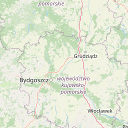
Park Narodowy „Bory Tucholskie” is situated within Poland and the Pomeranian Voivodeship administrative region. Records confirm that this protected area operates entirely inland without transboundary, coastal, island, or marine designations.
- Countries
- Poland
- Regions
- Pomeranian Voivodeship
- Primary location
- Pomeranian Voivodeship
- Geographic setting
- Inland
Boundary and coordinates
Interactive protected-area geometry and calculated spatial metrics
Park Narodowy „Bory Tucholskie” Boundary Map and Extent Metrics
Mapped boundary geometry provides clear spatial context for park geography across the protected landscape. Accompanying dimensional metrics supply derived area calculations, coordinate limits, and regional spans for spatial reference.
- Boundary area
- 46 km²
- Boundary perimeter
- 44.6 km
- Northernmost point
- 53.8566° N
- Southernmost point
- 53.7336° N
- Easternmost point
- 17.6184° E
- Westernmost point
- 17.4448° E
- Geographic centre
- 53.8148° N, 17.5657° E
- North–south span
- 13.7 km
- East–west span
- 11.4 km
Terrain and natural features
Lowland relief classification and recorded hydrological features
Park Narodowy „Bory Tucholskie” Terrain and Named Natural Features
Stored lowland relief classification governs the terrain profile across Park Narodowy „Bory Tucholskie”. Linked feature cards present names, types, and spatial relationships for recorded lakes and streams.
Selected named natural features
Lakes
Jezioro Płęsno
Lakes
Jezioro Krzywce Wielkie
Lakes
Jezioro Bełczak
Lakes
Dybrzyk Lake
Lakes
Jezioro Małe Krzywce
Environmental setting
Temperate lowland forests, wetlands, and major water systems within the protected landscape
Environmental Classifications and Physical Setting of Park Narodowy „Bory Tucholskie”
Recorded habitat types, climate zones, and relief classifications form complementary ways to read the physical setting of Park Narodowy „Bory Tucholskie”. Stored environmental categories connect directly to relevant atlas destinations across the protected area.
- Relief
- Lowland
- Climate
- Temperate
- Water
- Major water bodies
- Forest cover
- Mostly forested
- Seasonality
- Year-round
Landscape features
Forest · Wetland · Lakes · Rivers · Dunes
Habitat types
Temperate coniferous forest · Wetland · Lacustrine habitat · Riverine habitat
Park atlas
Compare nearby national parks and connected lowland forest landscapes across the region
Parks Near Park Narodowy „Bory Tucholskie” and Surrounding Protected Areas
Visitors exploring Park Narodowy „Bory Tucholskie” can continue browsing nearby national parks and protected lowland landscapes across the surrounding region. Expanding the geographic scope allows researchers and travelers to compare postglacial terrain, pine forest reserves, and clean lake ecosystems.
Protected areaPomeranian Voivodeship
Park boundaries overlap#1 closest
North

Sandr Brdy: Protected Glacial Landscapes and Hydrological Networks in Pomeranian Voivodeship
A vital reference site for lowland habitat conservation and post-glacial terrain.
Sandr Brdy spans 7,492 hectares of outwash plains in northern Poland. Its terrain hosts a complex mosaic of calcareous fens, acid oak forests, and lobelia lakes, established to preserve fragile aquatic and terrestrial species like the gray wolf and lady's slipper orchid within a unique glacial framework.
- Area
- 74.926 km²
- Scope
- Terrestrial
- Water
- Major water bodies

National parkPomeranian Voivodeship
Park boundaries overlap#2 closest
South
Tuchola Forest National Park: Explore Poland's Largest Protected Woodland and Glacial Lakes
Detailed maps and geographic context of unique forest ecosystems and terrain.
MoriAtlas offers a comprehensive geographic overview of Tuchola Forest National Park, a vital protected area in Pomeranian Voivodeship, Poland. This page delves into the park's identity as Poland's largest contiguous forest, distinguished by its post-glacial landscape. Users can explore the mapped boundaries of its extensive coniferous forests, numerous interconnected glacial lakes, dynamic dunes, and ecologically rich peatlands. It serves as a key entry point for understanding the park's unique terrain and its significant place within the broader regional geography and protected lands atlas.
- Area
- 46.13 km²
- Established
- 1996
- IUCN
- II
- Visitors
- 33K annual
Protected landscapePomeranian Voivodeship
Park boundaries overlap#3 closest
North
Zaborski Park Krajobrazowy: Geographic Profile of a Polish Protected Landscape Area
Tuchola Forest region, Pomeranian Voivodeship
Investigate the unique terrain of Zaborski Park Krajobrazowy, a protected landscape defined by its dense network of glacial lakes and sandy outwash plains. This territory provides a comprehensive view of northern Polish lowland geography, highlighting the ecological significance of its river valleys and relic forest habitats within the broader Tuchola Forest ecosystem.
- Area
- 340.3 km²
- Established
- 1990
- Relief
- Lowland
- Climate
- Temperate
Nature reservePomeranian Voivodeship
About 1.5 km away#4 closest
East
Rezerwat przyrody Moczadło: Protected Nature Reserve and Lobelia Lake in Pomeranian Voivodeship
Mapped ecological zone within the Bory Tucholskie lake region
Gain insight into the protected landscape of Rezerwat przyrody Moczadło, a nature reserve in Pomeranian Voivodeship defined by its exceptionally clear oligotrophic waters. This site offers valuable data for those studying post-glacial lake ecosystems, rare aquatic flora, and the sensitive transition zones between open water and peat-forming pine forest landscapes.
- Area
- 0.262 km²
- Established
- 2011
- Water
- Major water bodies
Nature reservePomeranian Voivodeship
About 3.3 km away#5 closest
West
Rezerwat przyrody Jezioro Małe Łowne: Protected Bog and Lake Landscape in Poland
A nature reserve in Pomeranian Voivodeship's wetland geography.
Located in the heart of the Bory Tucholskie forest region, this nature reserve protects a shallow post-glacial lake and its surrounding mire habitats. The protected area features a dynamic floating bog mat, boggy pine forests, and transitional peatlands, offering a clear look at the lowland hydrology and glacial topography that characterizes this specific part of northern Poland.
- Area
- 0.378 km²
- Established
- 1993
- Relief
- Lowland
- Climate
- Temperate
Nature reservePomeranian Voivodeship
About 5.7 km away#6 closest
Southwest
Jezioro Sporackie Nature Reserve: Mapped Geography and Protected Area Context
Exploring the lobelia lake and peatland mosaic in Pomeranian Voivodeship
Jezioro Sporackie Nature Reserve protects a vital ecological gradient ranging from nutrient-poor aquatic habitats to wooded terrestrial margins. The site preserves Sporacz, a glacial lake recognized for its specialized flora, alongside the surrounding transitional mire and forest compartments that form its primary buffer zone in Northern Poland.
- Area
- 0.176 km²
- Established
- 1965
- Relief
- Lowland
- Climate
- Temperate
Protected landscapeKuyavian-Pomeranian Voivodeship
8.9 km away#7 closest
Southeast
Tuchola Landscape Park: Mapped Protected Area and Riverine Geography in Poland
Pine-covered outwash plains and the meandering Brda River corridor
Covering a significant portion of northern Poland, Tuchola Landscape Park protects a distinctive postglacial landscape of sandy plains and dense pine forests. The park geography is anchored by the Brda River, which flows through a series of rapids and breakthroughs before reaching deep into the surrounding pine-clad outwash plain. Detailed map data provides insight into the park's eight nature reserves, which preserve critical wetland, bog, and riverine habitats.
- Area
- 369.83 km²
- Established
- 1985
- Relief
- Lowland
- Climate
- Temperate
Nature reservePomeranian Voivodeship
About 11 km away#8 closest
East
Rezerwat przyrody Mętne: An Atlas View of Peatlands in the Pomeranian Voivodeship, Poland
A preserved mosaic of mires, bog ecosystems, and forest lake habitats.
Rezerwat przyrody Mętne is a specialized protected area in northern Poland, centered on the intricate peat-building processes of the Tuchola Forest. The reserve features rare dwarf birch populations and sensitive bog communities, functioning as a critical natural site for hydrological stability. Gain insights into the mapped extent of these mire habitats and their ecological integration within the wider Bory Tucholskie landscape.
- Area
- 1.034 km²
- Established
- 1963
- Relief
- Lowland
- Scope
- Terrestrial
MoriAtlas Explorer
Deep Dive into the Protected Geography of Park Narodowy „Bory Tucholskie”
Continue your geographic exploration of the Pomeranian Voivodeship by studying the unique terrain and hydrological systems of Park Narodowy „Bory Tucholskie”. Through MoriAtlas, trace the boundaries of these protected pine forests and rare aquatic habitats to understand their role in the broader landscape of northern Poland.
Browse next
Global natural geography
Explore related park routes
Explore MoriAtlas Global ParksBrowse All MoriAtlas ParksGlobal Park Map DiscoveryMoriAtlas: Browse All CountriesBrowse All MoriAtlas ContinentsNational Park Environment AtlasGrand Canyon National Park AtlasYellowstone National Park AtlasYosemite National Park Atlas and GeographySerengeti National Park AtlasGalápagos National Park Protected LandscapeBanff National Park Geography and AtlasKruger National Park Atlas EntryUluṟu-Kata Tjuṯa National Park AtlasExplore Uluru-Kata Tjuta National Park GeographyPlitvice Lakes National Park AtlasFiordland National Park Protected LandscapeGreat Smoky Mountains National Park AtlasAfghanistan National Parks and Protected AreasAlbania National Parks and Protected AreasAlgeria National Parks and Protected AreasAmerican Samoa National Parks and Protected AreasAndorra National Parks and Protected AreasAngola National Parks and Protected AreasAntarctica National Parks and Protected AreasAntigua and Barbuda Park List