Mori Atlas logo
National parkBouba Njida National Park

Discover the mapped terrain and regional context of this national park in Central Africa.

Bouba Njida National Park Cameroon: Exploring Protected Landscape Boundaries and Geography

Bouba Njida National Park stands as a significant protected area within Cameroon, offering a unique entry point into the country's natural landscapes. This national park provides a distinct canvas for understanding mapped protected boundaries and the regional geography of Central Africa. Through its designation as a national park, Bouba Njida contributes to the broader atlas of conservation landscapes, inviting exploration of its terrain and its specific place within Cameroon's diverse natural heritage.

national parksavannah ecosystemelephant conservationpainted hunting dogprotected areaCentral Africa

Bouba Njida National Park

National park

Park overview

Structured park overview, official facts, and landscape profile for Bouba Njida National Park

Bouba Njida National Park park facts, protected area profile, and essential visitor context
Review the core facts for Bouba Njida National Park, including designation, size, terrain, visitor scale, habitats, and operating context in one park-focused overview.

About Bouba Njida National Park

Bouba Njida National Park represents one of Cameroon most important protected areas, encompassing a vast tract of savannah ecosystem in the country northern region. The park was originally established as a colonial-era reserve in 1932, reflecting early recognition of the region ecological wealth, and was elevated to full national park status in 1980. The protected area spans approximately 2,200 square kilometers, making it one of the larger national parks in Cameroon. The park landscape consists primarily of savannah forest and wooded grassland, creating ideal habitat for a diverse array of large mammals. The ecosystem supports remarkable biodiversity, with the park serving as a critical refuge for species that have been heavily impacted by hunting and habitat loss across the broader Central African region. The park location near Cameroon border with Chad places it within a broader network of transboundary conservation areas, though poaching pressure from neighboring countries has historically posed significant challenges to effective protection.

Quick facts and research context for Bouba Njida National Park

Bouba Njida National Park lies in northern Cameroon at elevations ranging from 251 to 864 meters above sea level. The park experiences an average annual rainfall of approximately 1,082 millimeters, supporting a mosaic of savannah forest and woodland habitats. Originally established as a reserve in 1932, the area was redesignated as a national park in 1980 and is classified under IUCN Category II. The park is renowned for its extraordinary antelope diversity, with 23 species recorded within its boundaries, and serves as one of the last strongholds for painted hunting dogs in Cameroon.

Park context

Deeper park guide and search-rich context for Bouba Njida National Park

Bouba Njida National Park history, landscape, wildlife, and travel context
Explore Bouba Njida National Park through its history, landscape character, ecosystems, wildlife, conservation priorities, cultural context, and seasonal travel timing in a structured park guide built for atlas discovery and search intent.

Why Bouba Njida National Park stands out

Bouba Njida National Park is best known for its remarkable large mammal populations, particularly the endangered painted hunting dog and significant savannah elephant herds. The park hosts one of the highest concentrations of antelope species in Central Africa, with 23 distinct species recorded. Its conservation significance is amplified by the presence of viable populations of painted hunting dogs, a critically endangered canid species with only approximately 60 individuals remaining in all of Cameroon. The park also gained notoriety in 2012 when heavily armed poachers from Chad and Sudan killed approximately 200 elephants, representing more than half of the park's elephant population.

Bouba Njida National Park history and protected-area timeline

Bouba Njida National Park traces its origins to the colonial period in Central Africa, when the area was first protected as a reserve in 1932 under French colonial administration. This early establishment reflects the recognition by colonial authorities of the region extraordinary wildlife populations and the need to prevent unsustainable exploitation. The reserve remained under various designations through the mid-twentieth century, maintaining protection despite limited enforcement capacity. In 1980, the protected area was elevated to national park status, granting it stronger legal protections and institutional support under Cameroon national conservation framework. The park has since faced significant conservation challenges, most notably a devastating poaching event in 2012 when heavily armed poachers from Chad and Sudan mounted a coordinated attack on the park elephant population. This incident resulted in the deaths of approximately 200 savannah elephants, wiping out more than half of the park elephant herds and representing one of the most significant poaching losses in Central African history.

Bouba Njida National Park landscape and geographic character

Bouba Njida National Park occupies a landscape of gently rolling savannah and forest mosaic in northern Cameroon. The terrain varies in elevation from approximately 251 meters to 864 meters above sea level, creating a relatively flat to undulating landscape typical of the Central African savanna zone. The park receives an average annual rainfall of about 1,082 millimeters, with precipitation concentrated during a distinct wet season that shapes the vegetation patterns throughout the protected area. The vegetation consists primarily of savannah forest, with areas of dense woodland alternating with more open grassland. This mosaic landscape provides diverse habitat niches for the park wildlife, from forest-dwelling species to those preferring more open savannah environments.

Bouba Njida National Park ecosystems, habitats, and plant life

The ecological character of Bouba Njida National Park is defined by its savannah forest ecosystem, which supports exceptional biodiversity despite ongoing conservation challenges. The park lies within the Central African savanna zone, where the mix of woodland and grassland creates productive habitat for numerous species. The protected area has been recognized for its particularly high antelope diversity, with 23 antelope species recorded within its boundaries representing one of the most diverse antelope communities in any protected area in the region. The savannah forest habitat supports both forest-dependent and savanna-adapted species, creating ecological diversity within a relatively compact protected area. The parks vegetation communities are shaped by the seasonal rainfall patterns and the underlying geology, with different areas supporting distinct plant assemblages that in turn sustain different wildlife communities.

Bouba Njida National Park wildlife and species highlights

Bouba Njida National Park is distinguished by its remarkable wildlife populations, particularly large mammals that have declined dramatically across much of Central Africa. The park hosts 23 antelope species, an extraordinary diversity that includes both forest-dwelling and savanna-adapted antelopes. Perhaps most significant is the parks population of painted hunting dogs, Lycaon pictus, a critically endangered canid species that has been largely eliminated from most of its historic range in Cameroon. By the year 2000, only approximately 60 painted hunting dogs remained in all of Cameroon, with Bouba Njida identified as one of only three national parks supporting remaining populations. Savannah elephants historically occurred in significant numbers within the park, though the 2012 poaching massacre eliminated more than half of the population. The park also supports other notable species including various predators and herbivores typical of the Central African savanna.

Bouba Njida National Park conservation status and protection priorities

Bouba Njida National Park holds significant conservation importance as one of Cameroons key protected areas for large mammal conservation. The parks designation as IUCN Category II reflects its primary mandate of protecting natural ecosystems and biodiversity. The protected area provides essential habitat for several threatened species, most notably the painted hunting dog which is considered critically endangered by the IUCN Red List. The parks elephant population, while severely impacted by the 2012 poaching incident, remains important for regional conservation given the decline of savannah elephants across Central Africa. The parks location near international borders creates both challenges and opportunities for conservation, as wildlife populations extend across political boundaries and face pressure from poaching networks operating across multiple countries. The 2012 tragedy, in which armed poachers from Chad and Sudan killed approximately 200 elephants, highlighted both the vulnerability of Cameroon wildlife and the need for enhanced anti-poaching efforts.

Top sights and standout views in Bouba Njida National Park

Bouba Njida National Park stands out as a savanna wilderness protecting one of Central Africa last significant populations of painted hunting dogs. The park extraordinary antelope diversity, with 23 species recorded, makes it a remarkable destination for wildlife viewing. Its elephant population, though devastated by poaching in 2012, remains a major attraction. The parks history as a colonial-era reserve established in 1932 gives it historical significance within Cameroon conservation framework. The combination of savannah forest habitat, large mammal populations, and critical endangered species makes Bouba Njida one of the most conservation-significant protected areas in Cameroon.

Best time to visit Bouba Njida National Park

The optimal time to visit Bouba Njida National Park corresponds with the dry season, typically from November to April, when wildlife concentrates around remaining water sources and vegetation is less dense, improving visibility for game viewing. The wet season from May to October brings heavier vegetation and more difficult conditions for wildlife observation, though the landscape becomes lush and bird activity increases. The dry season months offer the most reliable wildlife viewing opportunities, though visitors should be aware that the park has faced significant conservation challenges and access may be restricted. Dry season conditions also make roads more accessible for overland travel within the park.
Park location guide

Geography guide, regional context, and park location map for Bouba Njida National Park

Bouba Njida National Park park geography, regions, and map view in Cameroon
Understand where Bouba Njida National Park sits in Cameroon through a broader geographic reading of the surrounding landscape, nearby location context, and its mapped position within the national park landscape.

How Bouba Njida National Park fits into Cameroon

Cameroon is a Central African country spanning coastal, highland, and forest regions. It has a population of nearly 31 million people who speak 250 native languages alongside English and French as official languages. The country gained independence from France in 1960 and unified with British Southern Cameroons in 1961.

Wider geography shaping Bouba Njida National Park in Cameroon

Cameroon is located in Central Africa, bordering Nigeria and Chad to the west and north, the Central African Republic to the east, and Equatorial Guinea, Gabon, and the Republic of the Congo to the south. The country has a coastline on the Bight of Biafra, part of the Gulf of Guinea. Terrain includes coastal plains, mountainous highlands (including Mount Cameroon), plateaus, and dense rainforest regions.

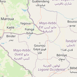
Map view of Bouba Njida National Park

Use this park location map to pinpoint Bouba Njida National Park in Cameroon, understand its exact geographic position, and read its mapped placement within the surrounding landscape more clearly.

Pigeon | © OpenStreetMap contributors
Park atlas

Compare regional park geography, tracing adjacent savannah ecosystems and broader Central African protected landscapes.

Explore Nearby National Parks and Protected Areas Beyond Bouba Njida National Park
Explore national parks and protected areas geographically related to Bouba Njida National Park, examining similar savannah ecosystems and conservation landscapes across Central Africa. Compare regional park geography and contiguous protected areas, deepening your understanding of shared features, wildlife habitats, and conservation efforts within the Central African savanna zone.
Watercolor illustration of a landscape with rolling hills, a winding river, and varied terrain in soft colors
National parkBénoué Department

Bénoué National Park: Protected Landscape Atlas in Bénoué Department, Cameroon

Explore savanna woodland, riparian ecosystems, and geographic context.

Bénoué National Park is a vast protected landscape in Cameroon, defined by its Sudanian savanna woodland and significant frontage along the Bénoué River. Recognized as a UNESCO Biosphere Reserve, it offers critical insights into regional geography, habitat diversity, and the broader atlas of conservation lands in West Africa. Users can explore its varied terrain, from riverine zones to higher massifs, gaining a detailed understanding of this important protected area.

Area
1,800 km²
Established
1968
IUCN
II
Relief
Mixed relief
National park

Faro National Park: Central Africa's Largest Hippo Population within Sudano-Sahelian Protected Landscape

Explore mapped boundaries and regional geography of this vital national park.

Faro National Park stands as a critical protected area within Cameroon, celebrated for its immense hippopotamus population and its role in conserving large mammals across the Sudano-Sahelian zone. The park's landscape comprises undulating savanna plains, river valleys, and elevated hilltops, offering a diverse geographic context for conservation. Its inclusion in a transboundary protected network highlights its importance for regional landscape mapping and ecological continuity. Understanding Faro National Park involves appreciating its unique habitat mosaic and its contribution to the protected areas atlas.

Area
3,418 km²
Established
1989
IUCN
II
Relief
Upland
National parkFar North Region

Waza National Park: A Designated Protected Landscape in the Far North Region

Mapped Boundaries and Regional Geographic Context

Waza National Park stands as a vital protected natural landscape in Cameroon's Far North Region. This entry provides a deep dive into its mapped protected-area boundaries and its significance within the broader regional geography. Explore the specific landscape identity of this national park through an atlas-focused lens, understanding its terrain and context without travel logistics or visitor advice.

Area
1,700 km²
Established
1934
IUCN
II
Relief
Lowland
National parkNigeria

Chad Basin National Park: Exploring Nigeria's Protected Natural Landscape

Mapped protected area and regional geography context.

Chad Basin National Park is a key protected landscape within Nigeria, designated as a national park. This page serves as a gateway to understanding its specific geographic identity, mapped boundaries, and its role within the country's natural terrain. Users can explore detailed information, focusing on the park's atlas-relevant features and its contribution to Nigeria's protected areas, offering a distinct view of the nation's geography.

Area
2,258 km²
Established
1991
IUCN
II
Relief
Lowland
National parkMoyen-Chari Region

Manda National Park: National Park Protected Landscape and Geographic Identity in Moyen-Chari

Discover mapped terrain and regional context for this Chad national park.

Manda National Park, a protected natural area within Chad's Moyen-Chari Region, offers valuable insights into regional geography and mapped protected landscapes. This detail page provides focused information on the park's identity as a national park, emphasizing its geographic setting and the importance of its mapped boundaries for structured atlas exploration. Understand how this protected area contributes to the diverse natural terrain of the Moyen-Chari Region.

Area
1,140 km²
Established
1969
IUCN
II
Climate
Tropical
National park

Deng Deng National Park: Protected Landscape & Gorilla Habitat in East Cameroon

Discover the mapped geography and conservation significance of this national park.

Deng Deng National Park in Cameroon's East Region offers a unique glimpse into the Northern Congolian forest-savanna mosaic ecoregion. Spanning about 683 square kilometers and shaped by the Sanaga River, it is critically important as the northernmost known habitat for western lowland gorillas. Its diverse terrain supports not only gorillas but also elephants, chimpanzees, and pangolins, highlighting its role in Central African biodiversity and regional landscape context.

Area
682.64 km²
Established
2010
IUCN
II
Climate
Tropical
National parkCentre Region

Mpem and Djim National Park: Protected Landscape and Regional Geographic Atlas

Explore the mapped terrain and protected boundaries of this national park.

Mpem and Djim National Park is a protected natural area situated within Cameroon's Centre Region. This detail entry provides an atlas-focused view, emphasizing the park's protected landscape characteristics and its position within the regional geography. Understand the mapped context and discover the identity of Mpem and Djim National Park as a key protected area.

Area
974.8 km²
Established
2004
IUCN
II
Relief
Upland
National parkGuéra Region

Zakouma National Park: Chad's Premier National Park and Protected Landscape

Explore the mapped savanna, acacia forests, and wildlife geography.

Zakouma National Park is Chad's oldest and most ecologically vital protected area, spanning 3,000 square kilometers of Sudano-Sahelian landscape. Situated within the Guéra Region, it is globally recognized for its exceptional Kordofan giraffe population, significant elephant recovery, and ongoing conservation successes, offering a unique view into African wildlife and protected area management.

Area
3,000 km²
Established
1963
IUCN
II
Relief
Lowland

Common questions about visiting, size, designation, and location context for Bouba Njida National Park

Bouba Njida National Park FAQs for park facts, access, geography, and protected area context
Find quick answers about Bouba Njida National Park, including protected-area facts, park geography, trail and visitor context, and how the park fits into its surrounding country and regional landscape.
MoriAtlas Explorer

Continue Your Protected Areas Search Across the Global Atlas

Deepen your exploration by continuing the structured search for national parks and protected areas worldwide. Utilize the comprehensive filtering capabilities to compare different conservation landscapes and refine your understanding of global park geography. Discover more about the distribution and characteristics of protected natural areas.

Global natural geography