
Mori Atlas logo
Nature reserveBruch an der Eichkanzel im Reinhardswald

Mapping the upland bog terrain and birch swamp forest within the Reinhardswald landscape

Bruch an der Eichkanzel im Reinhardswald: A Protected Nature Reserve in Hesse, Germany

Bruch an der Eichkanzel im Reinhardswald is a significant protected nature reserve situated in the forest expanse of the German state of Hesse. This upland plateau features a distinctive mosaic of bog vegetation, birch swamp forest, and small pools that create a unique hydrological environment. Discover the mapped boundaries and geographic context of this protected site to better understand its role within the wider regional geography of the Reinhardswald area.

nature reservebogbirch swamp forestmirepeatlandsphagnum moss
A flat-design illustration showing a narrow valley between steep cliffs with a small waterfall, a winding stream in the foreground, and dense evergreen forests.

Bruch an der Eichkanzel im Reinhardswald

Nature reserve

Park overview

Structured park overview, official facts, and landscape profile for Bruch an der Eichkanzel im Reinhardswald

Bruch an der Eichkanzel im Reinhardswald park facts, protected area profile, and essential visitor context

Review the core facts for Bruch an der Eichkanzel im Reinhardswald, including designation, size, terrain, visitor scale, habitats, and operating context in one park-focused overview.

About Bruch an der Eichkanzel im Reinhardswald

Bruch an der Eichkanzel im Reinhardswald is a small but ecologically distinct nature reserve set among the woodlands of the Reinhardswald, one of the largest contiguous forest areas in northern Hesse. The protected site lies northeast of Kassel, within the administrative boundaries of the Gutsbezirk Reinhardswald, a municipally unincorporated area managed separately from surrounding rural communities. Despite its modest size of about 17.5 hectares, the reserve conserves a representative slice of the boggy upland habitats that are increasingly rare in this part of central Germany.

Geographically, the area is situated east of the Junkernkopf, a local elevation within the Reinhardswald. The terrain forms a slightly elevated plateau with a semi-boggy character, where waterlogging and acidic, nutrient-poor soils have produced a mosaic of mire and woodland communities. The eastern half of the reserve is dominated by birch swamp forest (Birkenbruchwald), a habitat type associated with wet, peat-forming conditions. In contrast, the western half is more open and reveals the underlying hydrology of the site, with peat-forming vegetation clearly visible across the ground layer.

This combination of swampy woodland and open mire makes the reserve valuable both ecologically and as a reference site for understanding Reinhardswald's peatland history. Small, shallow pools scattered through the protected area add a third dimension to the habitat mosaic, providing breeding and foraging habitat for dragonflies and other moisture-dependent invertebrates. Beyond the reserve boundaries, the surrounding landscape continues as a mixture of open moor-like clearings and forested zones, creating a natural ecological buffer that helps maintain the hydrological conditions the site depends on.

Quick facts and research context for Bruch an der Eichkanzel im Reinhardswald

Bruch an der Eichkanzel im Reinhardswald is a designated Naturschutzgebiet in Hesse, Germany, covering roughly 17.5 hectares. It lies northeast of Kassel within the Gutsbezirk Reinhardswald, an unincorporated municipal area, and is part of the larger Naturpark Reinhardswald. The site has been protected since 12 May 1992 and carries the official Hessian nature reserve number 1633029, with corresponding entry 162574 in the World Database on Protected Areas.

Protection and recognition

Terrestrial conservation metrics and formal protected area designation records

Bruch an der Eichkanzel im Reinhardswald Protection Status and Recognition

Bruch an der Eichkanzel im Reinhardswald maintains a documented terrestrial protection scope within the global database without additional international recognition sources. Structured administrative records compile official designation metrics and boundary governance data for conservation analysis.

Protection details

Protection scope
Terrestrial
Transboundary protection
No
WDPA ID
162574
Park context

Deeper park guide and search-rich context for Bruch an der Eichkanzel im Reinhardswald

Bruch an der Eichkanzel im Reinhardswald history, landscape, wildlife, and travel context

Explore Bruch an der Eichkanzel im Reinhardswald through its history, landscape character, ecosystems, wildlife, conservation priorities, cultural context, and seasonal travel timing in a structured park guide built for atlas discovery and search intent.

Why Bruch an der Eichkanzel im Reinhardswald stands out

The reserve is best known for its combination of anmoorige (semi-boggy) upland terrain, a fragment of birch swamp forest, and open moorland vegetation that hosts characteristic bog indicators such as sphagnum mosses, sundews, cottongrasses, blue moor-grass, bog whortleberry, and lingonberry. The site also stands out for its small pools, which create habitat for dragonflies and other wetland fauna within an otherwise forested landscape.
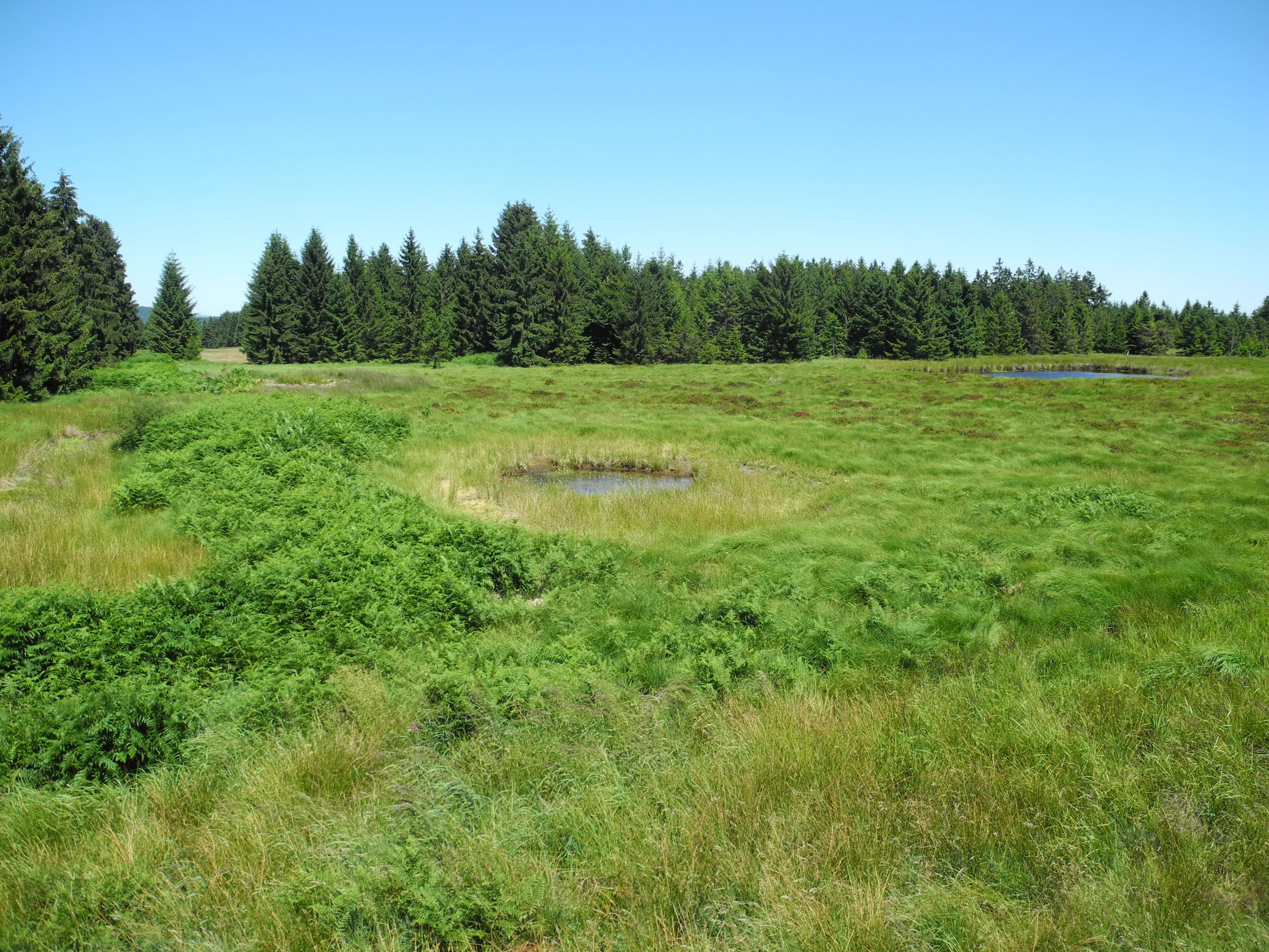
An open bog landscape with patches of green grass and small, circular pools of water, backed by a dense forest of evergreen trees under a clear blue sky.
A view of the open peatland and surrounding forest at the Bruch an der Eichkanzel nature reserve.

Bruch an der Eichkanzel im Reinhardswald history and protected-area timeline

The site was formally designated as a Hessian Naturschutzgebiet on 12 May 1992, receiving the official protected-area number 1633029. Its establishment reflects the regional recognition of the Reinhardswald's forested mires and upland bogs as habitats worth specific conservation attention within the Landkreis Kassel. The reserve continues to be administered under Hessian nature protection law and is listed in the World Database on Protected Areas under entry 162574.

Bruch an der Eichkanzel im Reinhardswald landscape and geographic character

The landscape of the Bruch an der Eichkanzel is defined by an anmoorige Hochfläche: a gently elevated plateau east of the Junkernkopf whose ground remains waterlogged for much of the year. The eastern sector is shaped by birch swamp forest, a low-growing, water-tolerant woodland community typical of peat-influenced terrain, while the western sector opens into Offenland, a mosaic of bog vegetation and bare, peaty ground.

Scattered across the reserve are several small pools (Tümpel), which appear as still-water pockets within the boggy upland. These pools are chiefly a hydrological feature, but they also shape the visual character of the site, creating reflective openings amid the surrounding mosses and low vegetation. Beyond the reserve borders, the Reinhardswald continues as a larger, mostly forested landscape that provides a calm, sheltered setting around the protected ground.

Bruch an der Eichkanzel im Reinhardswald ecosystems, habitats, and plant life

Ecologically, the reserve lies at the intersection of two closely related habitat types: boggy woodland and open mire. The eastern portion's birch swamp forest is built around moisture-loving birch, while the open western portion supports a community of bog specialists that thrive in acidic, nutrient-poor, permanently damp conditions. The coexistence of these two habitats in such a compact area gives the site strong conservation value.

Sphagnum mosses form a major component of the ground layer, locking up moisture and shaping the peat-forming dynamics of the reserve. Among the characteristic vascular plants are round-leaved sundew (Rundblättriger Sonnentau), sheathed cottongrass (Scheidiges Wollgras), narrow-leaved cottongrass (Schmalblättriges Wollgras), blue moor-grass (Pfeifengras), bog whortleberry (Rauschbeere), and lingonberry (Preiselbeere). Together, these species indicate the persistence of true bog-like conditions despite the reserve's relatively small footprint within an intensively forested region.

Bruch an der Eichkanzel im Reinhardswald wildlife and species highlights

While the reserve is primarily valued for its habitat rather than for charismatic large mammal populations, the small pools within the site are particularly important for dragonflies (Libellen), which use these shallow, still-water pockets as breeding habitat. Invertebrates associated with bog vegetation are among the most ecologically meaningful wildlife groups present.

The wet woodland and open mire mosaic also provides habitat structure for a range of smaller, moisture-dependent animals typical of the Reinhardswald's boggy uplands. The reserve's value for wildlife is closely tied to its intact hydrology: as long as the pools and saturated soils are maintained, the invertebrate and amphibian communities tied to these conditions can persist.

Bruch an der Eichkanzel im Reinhardswald conservation status and protection priorities

Bruch an der Eichkanzel im Reinhardswald is protected primarily for its peat-forming vegetation, its birch swamp forest, and its associated bog flora. These habitats have become rare across central Germany, and even small surviving fragments like this one hold disproportionate importance for regional biodiversity. The formal protection of the area under Hessian nature reserve law in 1992 was a recognition of the site's role in safeguarding anmoorige and bog-like communities within the larger forest landscape of the Reinhardswald.

The site's conservation significance is further enhanced by its location within the Naturpark Reinhardswald, a broader protected landscape framework that provides ecological buffering around the reserve. Maintaining the hydrological conditions of the boggy plateau, and preventing drainage, peat extraction, or conversion to other land uses, remains central to the reserve's ongoing protection value.

Bruch an der Eichkanzel im Reinhardswald cultural meaning and human context

The reserve sits within the Gutsbezirk Reinhardswald, one of the few remaining unincorporated municipal areas in Hesse and a historic forestry estate. The Reinhardswald itself has long been a regionally important forest landscape, and the naming of small bog sites like the Bruch an der Eichkanzel reflects a centuries-old tradition of distinguishing ecologically distinctive landforms within the forest. The reserve's existence reflects the modern continuation of that tradition of attention to the Reinhardswald's special natural features.

Top sights and standout views in Bruch an der Eichkanzel im Reinhardswald

The reserve's strongest points of distinction are its compact concentration of anmoorige upland habitats, its birch swamp forest fragment, its open bog vegetation with classic bog indicators such as sundews and cottongrasses, and the small pools that add valuable aquatic breeding habitat for dragonflies and other invertebrates. The surrounding forest and open ground of the Naturpark Reinhardswald provide a quiet, ecologically connected setting that complements the protected core.

Best time to visit Bruch an der Eichkanzel im Reinhardswald

Boggy upland habitats like this one are most visually rewarding in late spring and summer, when cottongrasses and other characteristic bog plants are in active growth and dragonflies are active around the small pools. Cooler, damper periods can enhance the sense of the site's hydrological character, while autumn brings the russet tones of the surrounding Reinhardswald forests into the broader landscape. Because the reserve is a protected nature area, visitors should plan walking for low-impact, ground-sensitive exploration rather than peak-visitor periods.

Monthly climate preview

Long-term temperature ranges and monthly precipitation averages across representative terrain

Climate Normals and Annual Weather Patterns at Bruch an der Eichkanzel im Reinhardswald

Representative coordinate records show measured temperature variation from sub-zero winter minimums to warm summer maximums alongside steady daily precipitation rates throughout the year. Reviewing the comprehensive twelve-month profile provides deeper insight into the long-term meteorological rhythms defining this protected landscape.
Annual mean8 °C
-1 °C18 °C
Jan-1°
Feb
Mar
Apr
May12°
Jun16°
Jul18°
Aug18°
Sep14°
Oct
Nov
Dec
Warmest month
July

18 °C

Coolest month
January

-0.6 °C

Wettest month
July

2.5 mm/day

Driest month
April

1.5 mm/day

Park location guide

Geography guide, regional context, and park location map for Bruch an der Eichkanzel im Reinhardswald

Bruch an der Eichkanzel im Reinhardswald park geography, regions, and map view in Germany

Understand where Bruch an der Eichkanzel im Reinhardswald sits in Germany through a broader geographic reading of the surrounding landscape, nearby location context, and its mapped position within the national park landscape.

How Bruch an der Eichkanzel im Reinhardswald fits into Germany

Germany is a federal republic in Western and Central Europe with a population of over 83 million across sixteen constituent states. It is Europe's largest economy by nominal GDP and a major global exporter and importer. The capital is Berlin, and the country borders Denmark, Poland, Czech Republic, Austria, Switzerland, France, Luxembourg, Belgium, and the Netherlands.

Wider geography shaping Bruch an der Eichkanzel im Reinhardswald in Germany

Germany is located in Western and Central Europe, spanning 357,022 km². It borders Denmark to the north, Poland and the Czech Republic to the east, Austria and Switzerland to the south, and France, Luxembourg, Belgium, and the Netherlands to the west. The country has coastlines on the Baltic Sea and North Sea to the north, with the Alps located in the southern region.

Map view of Bruch an der Eichkanzel im Reinhardswald

Use this park location map to pinpoint Bruch an der Eichkanzel im Reinhardswald in Germany, understand its exact geographic position, and read its mapped placement within the surrounding landscape more clearly.

Pigeon | © OpenStreetMap contributors

Location context for Bruch an der Eichkanzel im Reinhardswald

Hesse

Visual exploration of birch swamp forests, upland bogs, and waterlogged terrain across the nature reserve.

Bruch an der Eichkanzel im Reinhardswald Photos, Landscape Scenery, and Protected Habitats

Photographic records reveal the distinct character of the boggy upland plateau, birch swamp forest fragments, and open moorland vegetation found within the reserve. Visual documentation helps observers examine local terrain features, moisture-dependent habitats, and protected environmental conditions across the broader forest landscape.

An open bog landscape with patches of green grass and small, circular pools of water, backed by a dense forest of evergreen trees under a clear blue sky.

Park atlas

Compare adjacent forest reserves, wetland habitats, and protected terrain across the surrounding region

Other Parks Near Bruch an der Eichkanzel im Reinhardswald and Regional Protected Landscapes

Browsing other parks near Bruch an der Eichkanzel im Reinhardswald reveals connected woodland habitats and upland bog terrain across the surrounding region. Comparing adjacent protected areas expands geographic context beyond a single nature reserve into broader regional terrain.
Watercolor painting of a soft landscape featuring green trees and rolling hills in muted tones against a white background.
Nature reserveGermany
About 2.8 km away#1 closest

Southeast

Bruchwald am Gahrenberg Nature Reserve: A Protected Wetland Atlas of the Reinhardswald

Mapped terrain, bog woodland, and hydrological headwaters in Hessen

Located in the Reinhardswald forest massif, Bruchwald am Gahrenberg protects critical marsh and bog woodland habitats. The area serves as a primary source for regional streams, offering a dense, spring-fed landscape that stands out within the broader northern German wilderness.

Area
0.41 km²
Established
1992
Relief
Upland
Climate
Temperate
A soft watercolor illustration showing a band of green trees reflecting in calm water, with a light hilly background.
Nature reserveHessen
About 3.8 km away#2 closest

West

Bennhäuser Teich und Rothbalzer Teich bei Immenhausen: Protected Nature Reserve and Landscape Atlas

Mapped woodland and wetland habitats in Hessen, Germany.

This nature reserve centers on historic impoundment ponds and complex valley hydrology. Its landscape features rare dragonfly habitats and successional carr woodlands that define the ecological identity of this protected area within the northern Hessen countryside.

Area
0.315 km²
Established
1998
Watercolor painting of a calm wetland landscape with soft green trees along the water edge under a light, misty sky.
Nature reserveHessen
About 7.6 km away#3 closest

West

Rothenberg bei Burguffeln Protected Wetland Landscape and Nature Reserve in Hessen

A specialized pond and meadow mosaic in the Hessian lowlands

Rothenberg bei Burguffeln preserves a vital wetland complex near Immenhausen, structured across three distinct sections, including the Rothenküler Teich and Tonkaule. The area represents a significant example of culturally shaped lowland geography, blending historic aquaculture with contemporary habitat management. Its protected status reflects a commitment to maintaining intricate riparian corridors and meadow ecosystems within the wider Hessian countryside.

Area
0.278 km²
Established
1983
A horizontal watercolor illustration depicting rolling green hills, patches of forest, and a calm river in the foreground, rendered in soft, pastel tones.
Nature reserveHesse
About 9.7 km away#4 closest

South

Kragenhof bei Fuldatal Nature Reserve: Mapped Floodplain Landscapes in Hesse, Germany

Protected riparian ecosystems and river meander geography

Located in the state of Hesse, Kragenhof bei Fuldatal is a significant nature reserve protecting a complex mosaic of Fulda River floodplain habitats. The area features shifting currents, small wooded islands, and open grassland within a distinctive meander-driven landscape. Explore the geographic boundaries and ecological structure of this important regional waterbird refuge.

Area
0.077 km²
Established
1981
A watercolor painting showing a tranquil river landscape with soft green hills and reflections in calm water.
Nature reserveHessen
About 11 km away#5 closest

North

Ochsenhof Nature Reserve: Wetland Geography and Weser Floodplain Protected Areas

A riparian landscape mosaic in northern Hessen, Germany.

Located at the border of the vast Reinhardswald forest, Ochsenhof protects a valuable riverine corridor featuring reclaimed gravel-pit lakes and diverse wetland vegetation. This nature reserve provides essential habitat for waterfowl along the Weser, functioning as a sheltered landscape pocket within the regional protected-area network of northern Hessen.

Area
0.24 km²
Established
1981
IUCN
IV
A soft watercolor illustration of a winding stream flowing through a green meadow with rolling hills in the background and a small cluster of pine trees in the foreground.
Nature reserveHessen
About 11 km away#6 closest

Southwest

Jungfernbach und Brandteich bei Calden: Protected Forest and Stream Valley Geography

Regional nature reserve landscape located in northern Hessen

Examine the mapped boundaries and natural terrain of Jungfernbach und Brandteich bei Calden. This nature reserve offers a detailed look at lowland stream corridors, pond ecosystems, and riparian forest patches nestled within the rolling landscape of northern Hessen, reflecting the region's diverse protected land character.

Area
0.343 km²
Established
1985
Protected landscapeHessen
About 11 km away#7 closest

North

Naturpark Reinhardswald: A Comprehensive Protected Landscape Atlas for Northern Hessen

Mapping forest ecosystems and limestone river valleys

Naturpark Reinhardswald protects a diverse mosaic of environments across northern Hessen, characterized by the contrast between extensive sandstone-dominated forests and open limestone grasslands. The terrain features historic woodland pastures, basalt outcrops, and riverine floodplains, providing a significant regional network of nature reserves and protected areas that represent both upland forest and valley ecosystems.

Area
448.51 km²
Established
2017
Relief
Mixed relief
Scope
Terrestrial
A horizontal watercolor painting depicting a soft, atmospheric landscape with rolling green hills, a winding river or water feature, and distant pale mountains under a hazy, pastel sky.
Protected landscapeLower Saxony
About 11 km away#8 closest

Southeast

Naturpark Münden Protected Landscape: Geography and Regional Mapping in Lower Saxony

Forested ridges and river valleys in southern Germany

Naturpark Münden offers a detailed look at the central German low mountain range. Discover the mapping of the Kaufunger Wald and Bramwald, the significance of the Fulda and Werra river confluences, and the structure of this historically significant protected landscape located in Lower Saxony.

Area
374 km²
Established
1959
Relief
Mountain
Water
Major water bodies

Common questions about visiting, size, designation, and location context for Bruch an der Eichkanzel im Reinhardswald

Bruch an der Eichkanzel im Reinhardswald FAQs for park facts, access, geography, and protected area context

Find quick answers about Bruch an der Eichkanzel im Reinhardswald, including protected-area facts, park geography, trail and visitor context, and how the park fits into its surrounding country and regional landscape.
MoriAtlas Explorer

Continue Your Protected Areas Search Across the Global Atlas

Deepen your exploration by continuing the structured search for national parks and protected areas worldwide. Utilize the comprehensive filtering capabilities to compare different conservation landscapes and refine your understanding of global park geography. Discover more about the distribution and characteristics of protected natural areas.

Global natural geography