
Mori Atlas logo
Nature reserveBruchwiesen von Dorndiel

Mapping the habitat mosaic and stream valley landscape of the Buntsandstein Odenwald region

Bruchwiesen von Dorndiel Nature Reserve: A Detailed Geographic Atlas of Hessen Protected Lands

(Naturschutzgebiet Bruchwiesen von Dorndiel)

Bruchwiesen von Dorndiel is a significant nature reserve located within the Buntsandstein Odenwald landscape of southern Hessen. This protected area preserves a complex mosaic of wet meadows, reedbeds, and spring seepage zones along the Amorbach stream. The site serves as a vital wetland refuge within the regional ecological network, showcasing the natural interplay between forest-fringed valleys and traditional meadow ecosystems found in the Darmstadt-Dieburg and Odenwald districts.

wetland reservenature reservestream valleyreedbedswet meadowsBuntsandstein Odenwald
A flat-style digital illustration of a valley landscape featuring a waterfall cascading between rocky cliffs, surrounded by trees and a river in the foreground.

Bruchwiesen von Dorndiel

Nature reserve

Park overview

Structured park overview, official facts, and landscape profile for Bruchwiesen von Dorndiel

Bruchwiesen von Dorndiel park facts, protected area profile, and essential visitor context

Review the core facts for Bruchwiesen von Dorndiel, including designation, size, terrain, visitor scale, habitats, and operating context in one park-focused overview.

About Bruchwiesen von Dorndiel

Bruchwiesen von Dorndiel occupies a quiet corner of the Buntsandstein-Odenwald in southern Hesse, in the rolling low-mountain landscape between the Darmstadt-Dieburg and Odenwald districts. Roughly two kilometres southeast of the village of Dorndiel and only about half a kilometre from the edge of Wald-Amorbach, the nature reserve follows the valley of the Amorbach, a small tributary of the Mümling. Across roughly 650 metres of valley length, the protected area preserves a continuous mosaic of near-natural wet habitats that have become rare across much of central Europe.

The defining feature of the reserve is the fine-scale alternation of habitats within a very small footprint. Open water surfaces, reedbeds (Röhricht), wet meadows of differing moisture levels, small groups of trees, and active spring horizons all occur in close proximity. This structural diversity, combined with the natural course of the Amorbach and its associated ditch system, creates conditions that support a wide variety of plant communities and offer crucial breeding, feeding, and resting habitat for amphibians, insects, and birds, including species that are regionally uncommon.

Designated as a Naturschutzgebiet under German nature protection law and classified under IUCN Category IV as a Habitat/Species Management Area, the reserve has been formally protected since 8 December 1977, with the latest regulatory revision dating from 26 November 1990. Although the area is only about 8.65 hectares, it plays an outsized role in maintaining the ecological character of the Amorbach valley and represents the kind of small, intensively structured wetland site that anchors regional biodiversity in working agricultural landscapes.

Quick facts and research context for Bruchwiesen von Dorndiel

Bruchwiesen von Dorndiel is a designated nature reserve (Naturschutzgebiet) in the Buntsandstein-Odenwald of southern Hesse, located mainly in the municipality of Groß-Umstadt within the Landkreis Darmstadt-Dieburg. A small western portion extends into the municipality of Breuberg in the Odenwaldkreis. The reserve was placed under protection on 8 December 1977, while the regulation currently in force dates from 26 November 1990.

Its area is approximately 8.65 hectares, and it carries the official identifier 1432001, listed in the World Database on Protected Areas under WDPA-ID 81467. The protected area follows the Amorbach stream and its associated drainage ditches for about 650 metres through a small valley landscape.

Protection and recognition

Explore documented terrestrial conservation history and official registry records

Bruchwiesen von Dorndiel Protection Status and Designated Area Record

Bruchwiesen von Dorndiel maintains documented terrestrial protection status established in 1990 within official databases. Protected area records assemble designation history and management scope for environmental analysis.

Protection details

Protection scope
Terrestrial
Designated year
1990
Transboundary protection
No
WDPA ID
81467
Park context

Deeper park guide and search-rich context for Bruchwiesen von Dorndiel

Bruchwiesen von Dorndiel history, landscape, wildlife, and travel context

Explore Bruchwiesen von Dorndiel through its history, landscape character, ecosystems, wildlife, conservation priorities, cultural context, and seasonal travel timing in a structured park guide built for atlas discovery and search intent.

Why Bruchwiesen von Dorndiel stands out

Bruchwiesen von Dorndiel is best known for being a compact, ecologically rich wetland reserve that showcases the characteristic habitat mosaic of the Odenwald stream valleys: wet meadows of differing moisture levels, reed-dominated marsh zones, open water, small tree clusters, and active spring seepage horizons, all set along a natural section of the Amorbach stream and its old ditch network. The reserve is valued particularly as a refuge for breeding, feeding, and resting birds, amphibians, and insects that rely on the fine-grained structural diversity of these wet habitats. Despite its small size, it concentrates a surprising amount of biodiversity value typical of traditional, extensively used meadow-and-stream landscapes of the region.
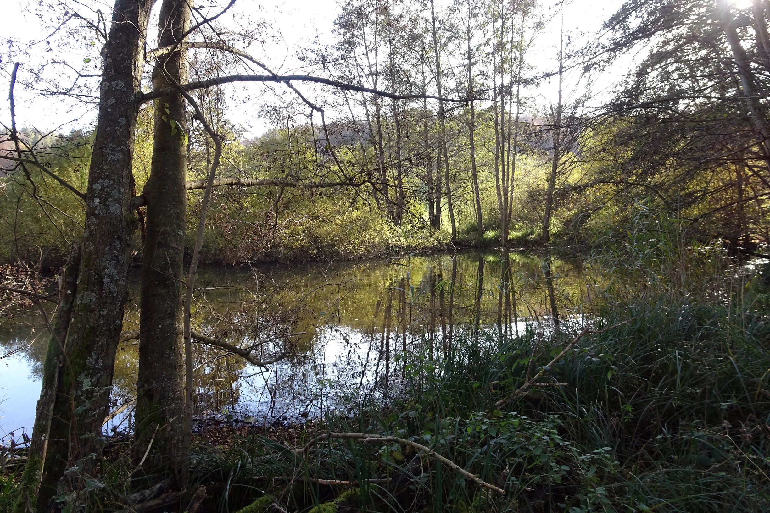
A calm, reflective pond nestled within a dense forest, with sunlight filtering through the trees.
A tranquil pond surrounded by deciduous trees in the Bruchwiesen von Dorndiel nature reserve.

Bruchwiesen von Dorndiel history and protected-area timeline

Bruchwiesen von Dorndiel was formally placed under nature protection (Naturschutz) on 8 December 1977, when it was designated as a Naturschutzgebiet under Hessian state law. The original protection order established the area as an official refuge for the wet meadows, reedbeds, and stream habitats found along the Amorbach valley between the villages of Dorndiel and Wald-Amorbach.

The legal framework governing the site was revised and updated on 26 November 1990, producing the regulation that still defines the reserve's boundaries, management objectives, and protective provisions today. While the reserve is small, the two key dates, 1977 for establishment and 1990 for the current ordinance, mark its transition from a traditionally used wet agricultural landscape into a formally protected ecological site integrated into the regional network of Hessian nature reserves.

In addition to its ecological role, the site carries a cultural-historical dimension: the meadows are also considered a likely location for the former moated castle (Wasserburg) Burg Waldamorbach associated with the historical noble family Schelle von Amorbach, linking the wetland landscape to the medieval land-use history of the valley.

Bruchwiesen von Dorndiel landscape and geographic character

The reserve lies within the Buntsandstein-Odenwald, a section of the Odenwald low mountain range dominated by red sandstone (Buntsandstein) geology, which produces gently rolling, forested terrain shaped by deeply cut stream valleys. The Bruchwiesen themselves occupy one of these modest valleys, where the Amorbach has carved a soft, low-lying meadow corridor through the surrounding wooded hills.

The protected area extends along roughly 650 metres of the Amorbach valley, with the main portion in the district of Landkreis Darmstadt-Dieburg and a small western sliver crossing into the Odenwaldkreis near Wald-Amorbach. In the north and northwest, the boundary of the reserve abuts the Kreisstraße 102, anchoring the wetland landscape to the surrounding road and settlement network.

Within this confined valley, the landscape is defined by the interplay of water and vegetation: open still water surfaces, dense reeds along the stream edges, wet meadows that gradually transition between moist and very wet conditions, small spring heads (Quellhorizonte), and groups of trees that rise out of the otherwise open meadow matrix. The result is a low-relief but visually varied rural landscape shaped by water, rather than by dramatic topography.
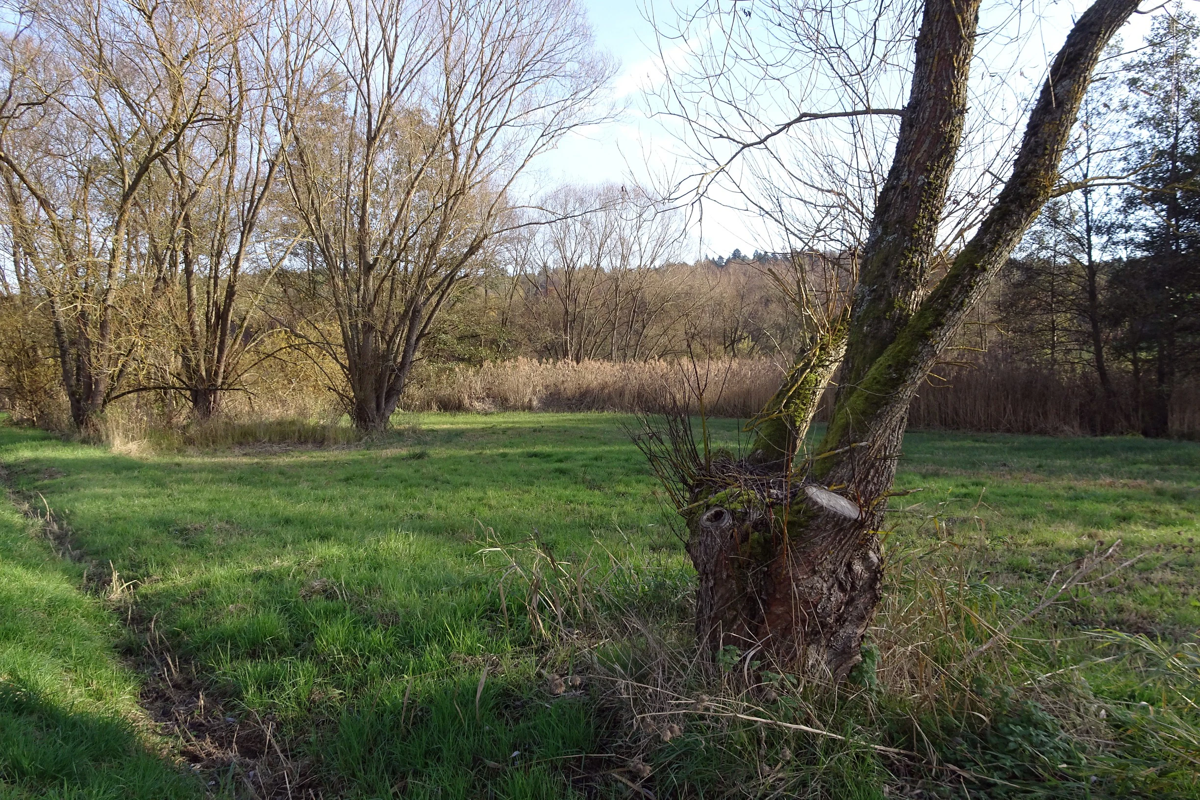
A green meadow in a nature reserve featuring a gnarled willow tree in the foreground, with more trees and a reed-lined horizon in the distance under a pale sky.
A view of the wetland meadow landscape at Bruchwiesen von Dorndiel nature reserve, featuring open grassland and willow trees.

Bruchwiesen von Dorndiel ecosystems, habitats, and plant life

Ecologically, Bruchwiesen von Dorndiel represents a textbook example of an Odenwald stream-valley wetland complex. The reserve integrates four core habitat types, open water, reedbed (Röhricht), wet meadows of differing moisture, and scattered tree groups, into a single, tightly interwoven landscape unit.

A central element of the site's ecological character is the near-natural condition of the Amorbach stream and its accompanying ditch network. These linear water features, together with the active spring seepage horizons within the meadows, maintain a constantly refreshed supply of clean groundwater that supports the entire habitat mosaic. The small-scale structural diversity that arises from this combination, alternating wet, moist, and slightly drier patches interspersed with reedbeds and isolated trees, is precisely what produces the reserve's high ecological density.

Because these conditions support such a varied substrate of moisture and vegetation in a compact area, the reserve functions as a key refuge for plants and animals that depend on traditional wet meadow and stream-valley systems, forms of habitat that have become increasingly scarce across the intensively used parts of central Germany.
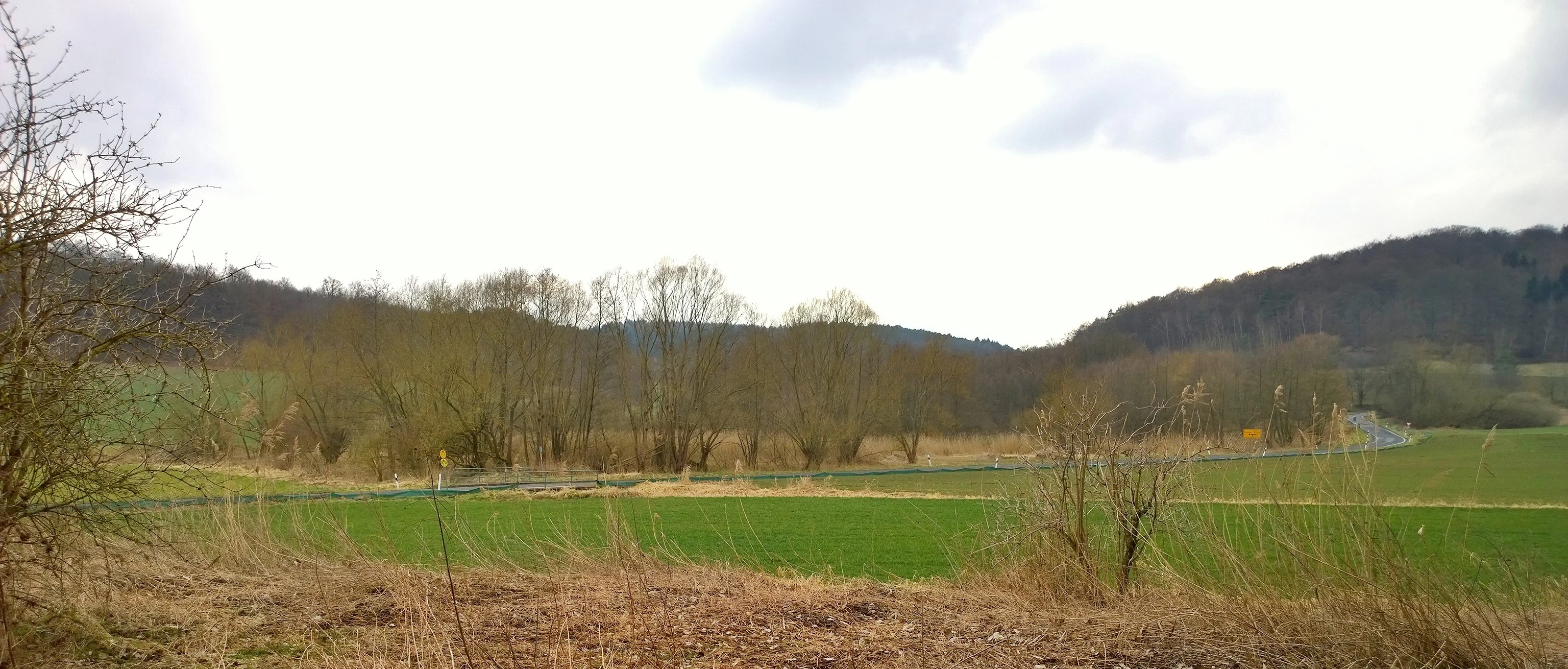
A wide, eye-level view of a rural landscape with green fields in the foreground, a line of trees in the midground, and rolling, forested hills in the background under an overcast sky.
A view of the Bruchwiesen von Dorndiel nature reserve landscape, showing open fields and surrounding wooded hills.

Bruchwiesen von Dorndiel wildlife and species highlights

The wildlife significance of Bruchwiesen von Dorndiel lies less in charismatic large species and more in the rich assemblage of smaller, often specialised animals that depend on the reserve's finely structured wetland mosaic. The combination of open water, reedbeds, wet meadows, springs, and tree groups provides breeding, feeding, and resting habitats across nearly the entire annual cycle.

According to the protection grounds documented for the site, the meadows serve as important habitat for rare bird species, with the reedbeds and wet meadows offering nesting cover, the open water providing foraging areas, and the surrounding mosaic supporting roosting and stopover use during migration. Amphibians benefit from the still water surfaces and wet meadow margins that remain suitable for breeding and juvenile development, while the diverse vegetation along the ditch system and stream edges supports a rich insect fauna.

The reserve's ecological value stems specifically from this fine-scale alternation of habitats: small structural shifts in vegetation and moisture create niches that, in aggregate, support a far larger and more varied faunal community than the reserve's modest 8.65 hectares would suggest.

Bruchwiesen von Dorndiel conservation status and protection priorities

Conservation at Bruchwiesen von Dorndiel is focused on the preservation of a small but ecologically intensive wetland complex in a region where such habitats have largely been lost to drainage and intensification of agricultural use. The reserve's protected status as a Naturschutzgebiet under Hessian law, combined with its IUCN Category IV classification as a Habitat/Species Management Area, reflects an explicit management orientation aimed at maintaining a specific set of habitat conditions rather than simply leaving an area untouched.

The protection order recognises the wet meadows of varying moisture levels, the reed stands, and the spring horizons along a near-natural stretch of the Amorbach with its ditch system as the core conservation objects. By keeping these habitats intact and allowing the natural flow and seepage patterns to continue, the reserve sustains the conditions needed for rare breeding birds, amphibians, and insects tied to wetland systems.

Because the reserve sits within a wider agricultural and settlement landscape, its conservation role is also tied to the broader regional network of protected areas in the Darmstadt-Dieburg and Odenwald districts, of which it forms an integral, if small, component.

Bruchwiesen von Dorndiel cultural meaning and human context

The cultural context of Bruchwiesen von Dorndiel is shaped by its long-standing role as a traditionally managed wet meadow landscape in the Odenwald, where stream valleys like the Amorbach have historically supported hay production, livestock grazing, and small-scale water management through ditch systems. These uses have, over centuries, helped create the exact habitat mosaic the reserve now protects.

In addition, the site is associated with medieval local history: the meadows are considered a probable location for the historical moated castle (Wasserburg) Burg Waldamorbach, connected with the Schelle von Amorbach noble family. While this is a secondary aspect compared with the reserve's ecological importance, it links the wetland landscape to the broader heritage of settlement and land use in the lower Odenwald valleys.

Top sights and standout views in Bruchwiesen von Dorndiel

The standout features of Bruchwiesen von Dorndiel lie in the integration of habitat types within a very compact area: a near-natural section of the Amorbach stream, open water surfaces, reed-dominated marsh zones, wet meadows across a moisture gradient, active spring seepage horizons, and scattered tree groups all combine in a single protected valley.

Equally important is the reserve's role as a refuge for regionally rare bird, amphibian, and insect species, and its position as a small but ecologically dense node in the protected-area network of southern Hesse, spanning both the Darmstadt-Dieburg and Odenwald districts.

Best time to visit Bruchwiesen von Dorndiel

As a quiet wetland reserve nestled in a forested Odenwald valley, Bruchwiesen von Dorndiel is best appreciated in the warmer months, when the wet meadows are actively growing, the reeds along the Amorbach are fully developed, and amphibian and insect activity is at its peak. Late spring and early summer tend to be particularly rewarding for observing the reedbeds, spring seepage zones, and the variety of vegetation along the stream.

Autumn also offers a distinct atmosphere, when the surrounding mixed forests of the Buntsandstein-Odenwald display seasonal colour around the meadow valley, and bird life shifts toward migration and winter visitors. Because the reserve is a protected site with no developed visitor infrastructure, visitors should generally expect a low-impact outdoor experience focused on observation of a small, ecologically rich landscape rather than on access to extensive facilities.

Monthly climate preview

Long-term representative monthly temperature and precipitation data for Hessen

Bruchwiesen von Dorndiel Climate Normals and Annual Temperature Rhythm

Bruchwiesen von Dorndiel exhibits a measured annual temperature range from near-freezing winter averages to warm summer highs alongside steady monthly precipitation records. Examining the complete twelve-month climatology profile provides deeper analytical context for long-term regional weather patterns.
Annual mean10 °C
0 °C21 °C
Jan
Feb
Mar
Apr10°
May14°
Jun18°
Jul21°
Aug20°
Sep15°
Oct10°
Nov
Dec
Warmest month
July

20.6 °C

Coolest month
January

0.2 °C

Wettest month
July

2.2 mm/day

Driest month
April

1.4 mm/day

Park location guide

Geography guide, regional context, and park location map for Bruchwiesen von Dorndiel

Bruchwiesen von Dorndiel park geography, regions, and map view in Germany

Understand where Bruchwiesen von Dorndiel sits in Germany through a broader geographic reading of the surrounding landscape, nearby location context, and its mapped position within the national park landscape.

How Bruchwiesen von Dorndiel fits into Germany

Germany is a federal republic in Western and Central Europe with a population of over 83 million across sixteen constituent states. It is Europe's largest economy by nominal GDP and a major global exporter and importer. The capital is Berlin, and the country borders Denmark, Poland, Czech Republic, Austria, Switzerland, France, Luxembourg, Belgium, and the Netherlands.

Wider geography shaping Bruchwiesen von Dorndiel in Germany

Germany is located in Western and Central Europe, spanning 357,022 km². It borders Denmark to the north, Poland and the Czech Republic to the east, Austria and Switzerland to the south, and France, Luxembourg, Belgium, and the Netherlands to the west. The country has coastlines on the Baltic Sea and North Sea to the north, with the Alps located in the southern region.

Map view of Bruchwiesen von Dorndiel

Use this park location map to pinpoint Bruchwiesen von Dorndiel in Germany, understand its exact geographic position, and read its mapped placement within the surrounding landscape more clearly.

Pigeon | © OpenStreetMap contributors

Location context for Bruchwiesen von Dorndiel

Hessen

Visual reference for wetland habitats, stream valleys, and spring seepage zones

Bruchwiesen von Dorndiel Photos and Protected Landscape Scenery

Photographic records capture the mosaic of wet meadows, reedbeds, and open water surfaces across the Amorbach stream valley. Visual exploration reveals the protected terrain and specialized marsh habitats defining this low mountain reserve in southern Hesse.

A calm, reflective pond nestled within a dense forest, with sunlight filtering through the trees.

A green meadow stretches toward a backdrop of autumn-colored trees and a forested hillside under a clear sky.

A green meadow in a nature reserve featuring a gnarled willow tree in the foreground, with more trees and a reed-lined horizon in the distance under a pale sky.

A wide, eye-level view of a rural landscape with green fields in the foreground, a line of trees in the midground, and rolling, forested hills in the background under an overcast sky.

Park atlas

Compare adjacent wetland reserves and regional stream valley landscapes

Explore Parks Near Bruchwiesen von Dorndiel and Surrounding Protected Areas

Browsing other protected areas near Bruchwiesen von Dorndiel reveals a wider network of regional wetland reserves and stream valley habitats. Comparing adjacent natural spaces provides deeper geographic context for the surrounding Odenwald landscape.
Watercolor painting of a wide, low-horizon landscape featuring a line of green trees against a pale pink sky over a pale, sandy foreground.
Nature reserveHessen
About 5.8 km away#1 closest

Southwest

Sandsteinbrüche am Burzelberg bei Frau-Nauses Protected Nature Reserve and Quarry Atlas

Odenwald mountain range, Hessen protected area

Examine the geography of Sandsteinbrüche am Burzelberg bei Frau-Nauses, a protected nature reserve in Hessen. This site features striking Buntsandstein quarry walls and rewilded forest edges, providing a specialized environment for cliff-nesting raptors and documenting local industrial history through its geological formations.

Area
0.195 km²
Established
1994
Relief
Upland
Climate
Temperate
Watercolor painting of a green, rolling landscape with clusters of trees on the left and right against a soft, light-filled sky.
Nature reserveHessen
About 6.4 km away#2 closest

Northwest

Buchertsgräben bei Schlierbach: Geographic Overview of the Hessian Nature Reserve

Protected forest landscape and geological loess ravine terrain

The Buchertsgräben bei Schlierbach nature reserve protects a vital woodland fragment in Hessen, where steep loess gullies cut through the landscape to create diverse microhabitats. This protected area supports a rare combination of semi-dry grassland relicts and forest-edge species, serving as a critical refugium for orchids and butterflies within the Odenwald foothills.

Area
0.516 km²
Established
1986
IUCN
IV
A soft watercolor painting of a wetland landscape with rolling hills in the background, a body of water in the middle, and green grass in the foreground.
Nature reserveHessen
About 12 km away#3 closest

South

Bruch von Bad König und Etzen-Gesäß: Nature Reserve and Floodplain Geography

Protected wetland landscapes in the Odenwald region of Hessen

Located along the Mümling river, this nature reserve protects a vital network of moist meadows, reed beds, and softwood forests. The site offers a clear view into the alluvial geography of the Odenwald, showcasing how protected floodplain corridors function within a developed regional landscape.

Area
0.427 km²
Established
1980
IUCN
IV
Relief
Lowland
Watercolor painting of a tranquil pond landscape with soft green reeds, grasses, and low trees under a pale, muted sky.
Nature reserveHesse
About 13 km away#4 closest

West

Reinheimer Teich Nature Reserve: Mapped Wetlands and Biodiversity in Hesse, Germany

A lowland wetland refuge in the Reinheimer Becken

Reinheimer Teich represents a significant nature reserve in the Darmstadt-Dieburg district of Hesse. This protected area features a mosaic of reed beds, wet meadows, and open water channels. It is recognized as one of the final strongholds for the European pond turtle and remains a key node within the Untere Gersprenz river system, demonstrating the vital role of floodplain restoration in local landscape conservation.

Area
0.75 km²
Established
1975
IUCN
IV
Relief
Lowland
A horizontal watercolor painting depicting a soft-focus landscape with green fields, patches of wildflowers, and distant low hills.
Nature reserveHessen
About 14 km away#5 closest

Northwest

Auf dem Sand zwischen Hergershausen und Altheim Protected Nature Reserve in Hessen

Inland dune and floodplain landscape mapping

Explore the geography of Auf dem Sand zwischen Hergershausen und Altheim, a nature reserve in Hessen. The area serves as a critical habitat mosaic, featuring sandy inland dunes, expansive wet grasslands, and renaturalized floodplain terrain within the Gersprenz valley.

Area
0.233 km²
Established
1998
IUCN
IV
A wide watercolor painting showing a river flowing through a green meadow with trees and distant hills.
Protected areaHesse
About 14 km away#6 closest

West

Scheelhecke von Groß-Zimmern Protected Area, Hesse: A Wetland and Riverine Landscape Study

Key protected wetland features in the Reinheimer Hügelland

Scheelhecke von Groß-Zimmern protects an essential network of wet meadows and brook corridors in the Darmstadt-Dieburg district. Its geography encompasses a transition from open sedge-dominated floodplain to softwood forest, providing critical support for avian species and amphibians within the Natura 2000 Gersprenz network.

Area
0.046 km²
Established
1983
Relief
Upland
Climate
Temperate
A soft watercolor illustration depicting a meadow landscape with a winding stream, distant hills, and foreground wildflowers.
Nature reserveHessen
About 14 km away#7 closest

Northwest

Die kleine Qualle von Hergershausen Nature Reserve and Protected Floodplain Landscapes

A preserved wetland fragment in the Hessen region

Die kleine Qualle von Hergershausen stands as a key protected area within the Gersprenz floodplain. This site offers a unique look at remnant wet meadow terrain, serving as an essential breeding and stopover ground for waterbirds in the Darmstadt-Dieburg district. Its geography provides a clear contrast to the surrounding agricultural fields, highlighting the impact of long-term conservation and habitat restoration efforts.

Area
0.27 km²
Established
1984
IUCN
IV
A watercolor illustration of a soft, pastel-colored wetland landscape with trees, grassy banks, and distant hills.
Nature reserveHesse
About 15 km away#8 closest

Southwest

Bruch von Brensbach: Mapping the Nature Reserve and Wetland Mosaic in Hesse, Germany

Protected carr woodland and Gersprenz valley stream corridors

Located in the Odenwaldkreis district of Hesse, Bruch von Brensbach acts as a crucial protected wetland corridor. The reserve preserves a rare concentration of alder carr forest and reed beds along the Kilsbach stream, offering a stark geographic contrast to the agricultural fields that characterize the broader Gersprenz valley landscape.

Area
0.055 km²
Established
1983
IUCN
IV

Common questions about visiting, size, designation, and location context for Bruchwiesen von Dorndiel

Bruchwiesen von Dorndiel FAQs for park facts, access, geography, and protected area context

Find quick answers about Bruchwiesen von Dorndiel, including protected-area facts, park geography, trail and visitor context, and how the park fits into its surrounding country and regional landscape.
MoriAtlas Explorer

Continue Your Protected Areas Search Across the Global Atlas

Deepen your exploration by continuing the structured search for national parks and protected areas worldwide. Utilize the comprehensive filtering capabilities to compare different conservation landscapes and refine your understanding of global park geography. Discover more about the distribution and characteristics of protected natural areas.

Global natural geography