
Mori Atlas logo
Protected landscapePřírodní park Buková hora – Chýlava

Analyzing the forested upland, acidophilous oak woodlands, and historic mining terrain of western Bohemia.

Přírodní park Buková hora – Chýlava Protected Landscape and Regional Geography Mapping

Přírodní park Buková hora – Chýlava represents a significant protected area within the Plzeňský kraj region of the Czech Republic, encompassing roughly 28 square kilometers of rolling upland terrain. This geographic analysis traces the park boundaries from the Úslava river valley to the 651-meter summit of Buková hora, exploring the intersection of continuous acidophilous oak woodlands, core nature reserves, and the deep imprint of historical iron and uranium mining on the local landscape.

nature parkoak forestacidophilous woodlandforested uplandriver valleyÚslava watershed
A flat-style digital illustration of a green hilly landscape with trees along a path, peach-colored clouds, and a yellow sun in a light blue sky.

Přírodní park Buková hora – Chýlava

Protected landscape

Park overview

Structured park overview, official facts, and landscape profile for Přírodní park Buková hora, Chýlava

Přírodní park Buková hora, Chýlava park facts, protected area profile, and essential visitor context

Review the core facts for Přírodní park Buková hora, Chýlava, including designation, size, terrain, visitor scale, habitats, and operating context in one park-focused overview.

About Přírodní park Buková hora, Chýlava

Přírodní park Buková hora – Chýlava is a mid-sized Czech nature park centered on a forested upland on the left bank of the Úslava river, in the Plzeň-jih district of the Plzeň Region. Established in 1983, it covers approximately 28 square kilometers and protects an exceptionally coherent block of woodland in a region otherwise shaped by villages, farmland, and transport corridors.

Geologically, the park sits on consolidated sedimentary bedrock with varied rock types, a substrate that supports a distinctive vegetation pattern. From a geobotanical standpoint the dominant community is the acidophilous oak woodland, in which oaks share the canopy with rowans, alder buckthorn, aspens, and birches. This mix gives the forests an open, compositional quality typical of warmer low-mountain slopes in western Bohemia and helps frame the park's appeal for walkers and naturalists interested in Central European woodland communities.

The landscape rises from roughly 405 meters near the hamlet of Nová Huť, by Blovice, to 651 meters at the summit of Buková hora itself. Within the park lies the Chejlava National Nature Reserve, which anchors the area's conservation significance within a broader matrix of protected forest. The park is bordered to the west by the first-class road I/20 linking Plzeň with České Budějovice and to the east by railway line 191, making the surrounding settlements of Blovice, Chocenice, Ždírec, Myť, Klášter, Měcholupy, and Zhůř the natural gateways to the protected landscape.

Quick facts and research context for Přírodní park Buková hora, Chýlava

The nature park lies in the Plzeň-jih district of the Plzeň Region and was formally designated in 1983. It extends across about 28 square kilometers on the left bank of the Úslava river, with terrain ranging from roughly 405 meters near the settlement of Nová Huť up to 651 meters at the summit of Buková hora.

Its geology is built on consolidated sediments of varied composition, while its vegetation is dominated by acidophilous oak forests featuring oaks, rowans, alder buckthorn, aspens, and birches. The park also includes the Chejlava National Nature Reserve and borders several historic settlements, including parts of Blovice and the former village of Chýlava.

Protection and recognition

Documented terrestrial protection scope, designation history, and management framework

Přírodní park Buková hora – Chýlava Protection Status and Recognition

Přírodní park Buková hora – Chýlava maintains a documented terrestrial protection scope within the regional protected area framework. Review the official designation parameters, management boundaries, and recorded international status details.

Protection details

Protection scope
Terrestrial
Transboundary protection
No
Park context

Deeper park guide and search-rich context for Přírodní park Buková hora, Chýlava

Přírodní park Buková hora, Chýlava history, landscape, wildlife, and travel context

Explore Přírodní park Buková hora, Chýlava through its history, landscape character, ecosystems, wildlife, conservation priorities, cultural context, and seasonal travel timing in a structured park guide built for atlas discovery and search intent.

Why Přírodní park Buková hora, Chýlava stands out

The park is best known for its broad, contiguous forest cover above the Úslava valley, where acidophilous oak woodlands with rowans, alder buckthorn, aspens, and birches form the dominant geobotanical character. It is also notable as a protected setting that encloses the Chejlava National Nature Reserve and frames the highest local summit, Buková hora, at 651 meters. A further layer of identity comes from the area's mining heritage, with historical iron ore extraction and later uranium mining leaving a tangible imprint on the landscape's cultural as well as its natural history.
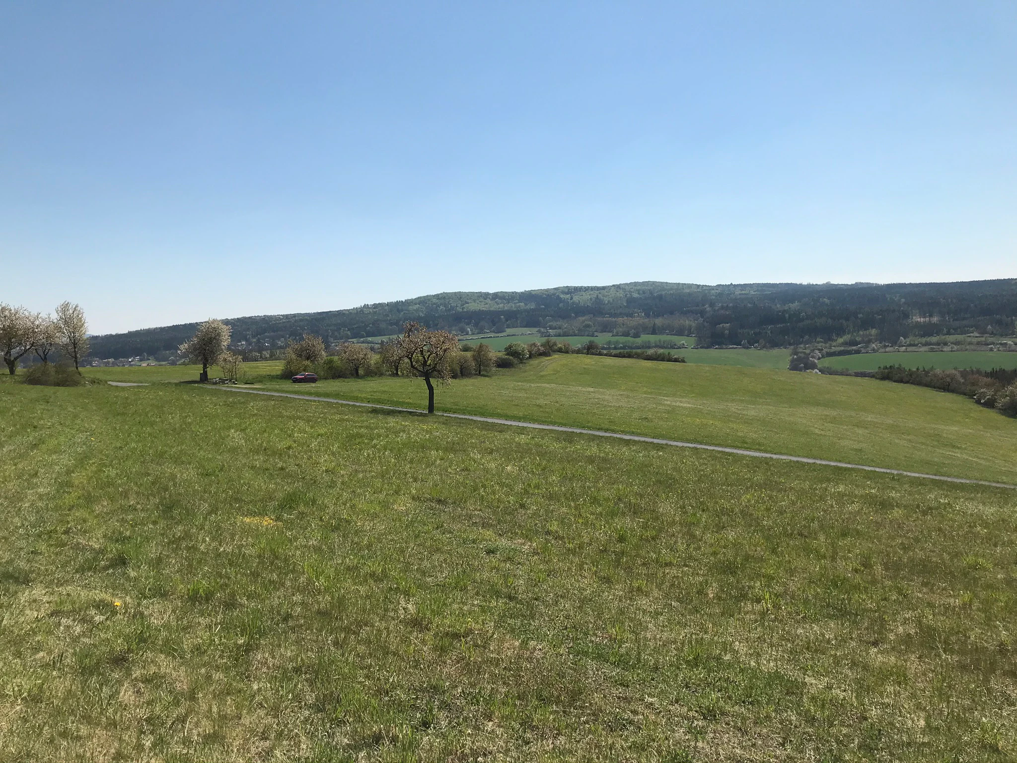
A wide view of a grassy meadow in the foreground leading to a rolling, forested mountain ridge under a clear blue sky.
A view of the rolling hills and forest cover of Bukova hora.

Přírodní park Buková hora, Chýlava history and protected-area timeline

The nature park was formally established in 1983, when the forested left-bank landscape above the Úslava river was recognized as worthy of regional protection in the Plzeň-jih district. Its designation brought together an existing patchwork of communities, hamlets, and remnant industrial sites under a single protective framework.

Long before protection, the area had a working industrial identity. It was historically a site of iron ore mining, and in later periods uranium ore extraction was also carried out within the wider territory. These mining episodes shaped local settlements such as Stará Huť and Nová Huť, whose names themselves reference the metallurgical and smelting past of the region. The park today overlays these former workings with a contemporary conservation purpose, while the village of Chýlava, which gives the park its second name, is now a depopulated, vanished settlement within the protected area.

Přírodní park Buková hora, Chýlava landscape and geographic character

The park occupies a rolling upland on the left bank of the Úslava, where the terrain rises from about 405 meters near Nová Huť to 651 meters at the Buková hora summit. The result is a landscape of wooded ridges, valleys, and gentle slopes rather than dramatic peaks, with the Úslava river defining the eastern boundary of the protected zone.

The substrate is made up of consolidated sediments of varied composition, producing a patchwork of soil conditions that supports the diverse woodland cover seen across the park. Although the area is largely forested, the terrain is clearly inhabited at its margins, with hamlets, roads, and railway lines framing the woodland core: the I/20 road lies along the western edge, and railway line 191 runs along the eastern side.

Přírodní park Buková hora, Chýlava ecosystems, habitats, and plant life

Vegetationally, the park is defined by acidophilous oak woodland communities, a geobotanical category characteristic of warmer, drier, often nutrient-poor sites. The canopy is built from oaks and is accompanied by characteristic companions: rowans, alder buckthorn, aspens, and birches, which together produce a varied, structurally rich forest rather than a uniform oak monoculture.

Within this broader woodland matrix sits the Chejlava National Nature Reserve, a nationally protected enclave that concentrates the park's most sensitive biodiversity and adds a higher tier of conservation significance to the surrounding regional nature park. The mix of broad forest cover, elevation change, and sedimentary substrates gives the park a meaningful gradient of habitats across a relatively compact area.

Přírodní park Buková hora, Chýlava wildlife and species highlights

The source material does not provide detailed species inventories, so a finely resolved discussion of fauna cannot be supported. What can be said is that the park's extensive, structurally varied deciduous woodland, built around oaks, rowans, alder buckthorn, aspens, and birches, provides the kind of continuous cover and habitat diversity that supports typical Central European forest fauna, while the embedded Chejlava National Nature Reserve offers a more strictly protected refuge for the area's most sensitive species.

Přírodní park Buková hora, Chýlava conservation status and protection priorities

Conservation significance in Přírodní park Buková hora – Chýlava rests on the protection of an unusually coherent block of acidophilous oak woodland in the western Bohemian countryside, anchored by the nationally protected Chejlava National Nature Reserve within the larger park. The protected status, established in 1983, safeguards not only the forest communities but also the underlying geological substrate of consolidated, varied sediments that supports them.

The park also represents a regional counterweight to the pressures of surrounding infrastructure, sitting between the I/20 road corridor to the west and railway line 191 to the east. Its value is therefore both intrinsic, in preserving representative Bohemian oak woodland and an embedded national reserve, and contextual, in maintaining a forested buffer in a region otherwise shaped by settlement, agriculture, and transport routes.

Přírodní park Buková hora, Chýlava cultural meaning and human context

The park is closely interwoven with its surrounding villages, including parts of Blovice such as Vlčice and Stará Huť, as well as the municipalities of Chocenice, Ždírec, Myť, Klášter, Měcholupy, and Zhůř, and smaller hamlets like Nová Huť, Hladoměř, Harvánek, Batov, Nový Mlýn, and Dubeč. The settlement names themselves, particularly Stará Huť and Nová Huť, reflect a long history of iron smelting and mining that gave the region its working character.

Within the protected area also lies Chýlava, once a living village and now a depopulated, vanished settlement that lends the park its second name. This layered history, of vanished villages, former iron works, and later uranium mining, gives the protected forest a quietly human dimension that complements its natural value.

Top sights and standout views in Přírodní park Buková hora, Chýlava

The park's standout features include its continuous, well-preserved acidophilous oak forests stretching across roughly 28 square kilometers on the left bank of the Úslava, and the inclusion of the Chejlava National Nature Reserve as a core of stricter protection within that woodland matrix. The summit of Buková hora at 651 meters provides the highest and most defining viewpoint over the protected landscape.

Equally distinctive is the way the forested upland is framed by human geography: historic iron-mining settlements such as Stará Huť and Nová Huť, the vanished village of Chýlava, and the bordering corridors of the I/20 road and railway line 191 all give the nature park a sense of being a protected island within a deeply settled western Bohemian landscape.

Best time to visit Přírodní park Buková hora, Chýlava

The nature park's character is shaped by its deciduous oak forests, which make late spring and early summer appealing for seeing fresh leaf cover and active woodland life, while autumn brings strong color across the oaks, birches, and aspens and the most visually distinctive forest atmosphere. Winter offers quieter, more open conditions across the ridges and clearer views toward the Buková hora summit, though access will reflect general Bohemian upland weather rather than any park-specific schedule. Deciduous forest parks of this kind are best enjoyed outside the deepest summer heat, when shaded woodland walking is most comfortable.

Monthly climate preview

Long term representative point measurements for annual temperature and precipitation patterns

Přírodní park Buková hora – Chýlava Climate Normals and Temperature Rhythms

Representative coordinates record measured monthly temperature ranges and precipitation rates across a twelve month climatology period. Detailed twelve month climate normals provide deeper analytical context for long term atmospheric patterns within the protected landscape.
Annual mean8 °C
-3 °C19 °C
Jan-3°
Feb-2°
Mar
Apr
May12°
Jun16°
Jul19°
Aug18°
Sep13°
Oct
Nov
Dec-2°
Warmest month
July

18.5 °C

Coolest month
January

-2.8 °C

Wettest month
June

2.9 mm/day

Driest month
February

1.4 mm/day

Park location guide

Geography guide, regional context, and park location map for Přírodní park Buková hora, Chýlava

Přírodní park Buková hora, Chýlava park geography, regions, and map view in Czechia

Understand where Přírodní park Buková hora, Chýlava sits in Czechia through a broader geographic reading of the surrounding landscape, nearby location context, and its mapped position within the national park landscape.

How Přírodní park Buková hora, Chýlava fits into Czechia

Czech Republic is a landlocked Central European country with a population of approximately 10.9 million people. The nation was established as an independent state on January 1, 1993, following the dissolution of Czechoslovakia. Its capital and largest city is Prague, with other major urban centers including Brno, Ostrava, Plzeň, and Liberec.

Wider geography shaping Přírodní park Buková hora, Chýlava in Czechia

The Czech Republic is a landlocked country in Central Europe. It is bordered by Germany to the west, Austria to the south, Poland to the northeast, and Slovakia to the southeast. The landscape is predominantly hilly, with the territory covering 78,871 square kilometers.

Map view of Přírodní park Buková hora, Chýlava

Use this park location map to pinpoint Přírodní park Buková hora, Chýlava in Czechia, understand its exact geographic position, and read its mapped placement within the surrounding landscape more clearly.

Pigeon | © OpenStreetMap contributors

Location context for Přírodní park Buková hora, Chýlava

Plzeňský kraj

Visual exploration of oak woodlands, ridges, and the Úslava river valley

Přírodní park Buková hora – Chýlava Photos and Protected Landscape Scenery

Visual records capture the continuous acidophilous oak forests and rolling upland terrain defining Přírodní park Buková hora – Chýlava. Detailed imagery reveals the protected nature reserve habitats and varied topography across the western Bohemian landscape.

A wide view of a grassy meadow in the foreground leading to a rolling, forested mountain ridge under a clear blue sky.

Park atlas

Compare surrounding upland reserves and forested river valleys across western Bohemia.

Parks Near Přírodní park Buková hora – Chýlava and Connected Protected Landscapes

Continue exploring regional park geography by comparing protected oak woodlands and river valley reserves adjacent to Přírodní park Buková hora – Chýlava. Expanding the geographic scope reveals how similar upland ecosystems distribute across the surrounding Bohemian terrain.
Natural monumentPlzeňský kraj
About 12 km away#1 closest

South

Velký kámen Natural Monument: Protected Siliceous Outcrops and Regional Geography

Geological landscape within the Plánický hřeben area of Plzeňský kraj.

Velký kámen serves as a notable protected landmark featuring an elongated siliceous rock formation and remnants of natural beech forest. Its location on the V Kopaninách hillside makes it a key feature of the broader regional geography, while its status as both a natural monument and an Eneolithic archaeological site provides a layered perspective on the Bohemian landscape.

Area
0.012 km²
IUCN
IV
Relief
Upland
Scope
Terrestrial
A watercolor painting showing a panoramic view of soft rolling green hills, a small stream, and wildflowers in the foreground.
Natural monumentJihočeský kraj
About 22 km away#2 closest

Southeast

Smyslov Natural Monument: Mapping Protected Habitats in the South Bohemian Region

Traditional pastoral landscapes and botanical meadow mosaics

Smyslov stands as a significant natural monument in the Jihočeský kraj, illustrating the traditional ecological structure of the Blatná area. The site is defined by its tight combination of dry, rocky slopes featuring juniper, and shallow depressions hosting moisture-loving vegetation. Explore this distinct protected area to understand its role in conserving rare meadow flora and traditional South Bohemian terrain.

Area
0.078 km²
Established
1990
IUCN
IV
Relief
Lowland
A watercolor illustration of a rolling, green landscape with distant, faint hills and small ponds or water bodies in the foreground.
Natural monumentPlzeňský kraj
About 24 km away#3 closest

North

Rokycanská stráň Natural Monument: Geological Exposures and Regional Protected Landscapes

Stratigraphic reference site in the Plzeňský kraj, Czech Republic

Rokycanská stráň represents a key geological protected area situated on the outskirts of Rokycany. The site protects the Klabava Formation stratotype and fossil-rich shales, functioning as a benchmark for Ordovician geology in the Barrandian area. Its four distinct parcels illustrate the interface between urban development and important paleontological research sites in the Plzeň region.

Area
0.208 km²
Established
1981
IUCN
IV
Relief
Upland
A horizontal watercolor illustration depicting soft, rolling hills in shades of green, yellow, and light pink with small clusters of trees.
Nature reservePlzeňský kraj
About 26 km away#4 closest

South

Prácheň Nature Reserve: Protected Broadleaf Woodlands and Historic Castle Remains

An atlas view of Bohemian forest geography and heritage landscapes

Prácheň Nature Reserve protects a compact block of warm-loving deciduous woodland set atop a hilltop in the Plzeňský kraj region. The area integrates significant natural habitats with cultural heritage, encompassing an early medieval hillfort and castle ruins. This unique blend of forest ecology and Bohemian historical geography offers a distinct perspective on protected areas within the southwestern Czech landscape.

Area
0.283 km²
Established
1953
IUCN
IV
Relief
Upland
A horizontal watercolor painting showing rolling green hills and distant purple ridges against a white background.
Protected landscapeKlatovy District
About 27 km away#5 closest

South

Přírodní park Buděticko: Protected Landscape and Geographic Atlas of Klatovy District

Orchid-rich meadows and riparian terrain in the Bohemian foothills

Přírodní park Buděticko serves as a vital protected landscape in the Klatovy District, characterized by the transition between the Šumava foothills and broader upland plains. This area supports a mosaic of orchid-rich limestone meadows and riparian habitats along the Otava River. Discover the park's geological character and its integration of natural biodiversity with the cultural heritage of southwestern Bohemia.

Area
44 km²
Established
1994
Relief
Upland
Climate
Temperate
Natural monumentPlzen Region
About 29 km away#6 closest

North

Malochova skalka Natural Monument: Geographic Profile and Protected Landscape Identity

Unique spilite rock formations in the Plzen Region

Located in the Plzen Region, Malochova skalka is a protected natural monument defined by steep spilite cliffs and rare botanical assemblages. This site offers insight into the complex interaction between volcanic-derived bedrock, river valley topography, and oak-hornbeam forest, serving as a concentrated example of the varied natural terrain found throughout this section of the Czech Republic.

Area
0.015 km²
Established
1970
IUCN
IV
Relief
Upland
A soft, light watercolor illustration of a rocky outcrop surrounded by evergreen trees against a hazy, distant mountainous background.
Natural monumentPlzeňský kraj
About 33 km away#7 closest

Northwest

Malesická skála Natural Monument and Geological Heritage in Plzeňský kraj

Protecting rare sedimentary rock formations and oak-pine forest habitats

Malesická skála serves as a significant geological reserve, protecting a unique elliptical rock pillar that reveals the history of Carboniferous stream currents. Visitors can study the complex surface textures formed by iron-bearing cementation, including dramatic rock caps and weathered ledge systems. The surrounding woodland, characterized by an oak-pine bilberry forest, provides an essential natural context for this rare Bohemian landmark.

Established
1974
IUCN
III
Relief
Upland
Climate
Temperate
A pale, soft watercolor painting of a rolling, grassy meadow landscape with a prominent green mushroom in the foreground and sparse, leafless trees.
Natural monumentJihočeský kraj
About 35 km away#8 closest

East

Malý Kosatín: Protected Botanical Landscapes in the South Bohemian Region of Czechia

A rare fen-meadow sanctuary in the Písek District

Located in the heart of the Czech countryside, Malý Kosatín is a natural monument distinguished by its intense botanical density and traditional meadow management. The site serves as a crucial habitat for threatened orchids and sedge communities, providing a focused view of the ecological character that defines the upland terrain surrounding the Písek District.

Area
0.01 km²
Established
1986
IUCN
IV
Relief
Upland

Common questions about visiting, size, designation, and location context for Přírodní park Buková hora, Chýlava

Přírodní park Buková hora, Chýlava FAQs for park facts, access, geography, and protected area context

Find quick answers about Přírodní park Buková hora, Chýlava, including protected-area facts, park geography, trail and visitor context, and how the park fits into its surrounding country and regional landscape.
MoriAtlas Explorer

Continue Your Protected Areas Search Across the Global Atlas

Deepen your exploration by continuing the structured search for national parks and protected areas worldwide. Utilize the comprehensive filtering capabilities to compare different conservation landscapes and refine your understanding of global park geography. Discover more about the distribution and characteristics of protected natural areas.

Global natural geography