
Mori Atlas logo
Nature reserveBurghain Falkenstein

A dense urban-adjacent forest island protecting beech and oak ecosystems within the Taunus range

Burghain Falkenstein Nature Reserve: Geographic Atlas and Protected Forest Landscape in Hessen

Burghain Falkenstein represents a critical protected woodland enclave within the Hochtaunuskreis region of Hessen, Germany. This nature reserve, which encompasses the conical Burgberg hill, preserves native beech and oak-hornbeam forest communities that stand in sharp contrast to the surrounding suburban development of Königstein im Taunus. The site integrates significant natural conservation values with historic medieval foundations, creating a unique topographic island that serves as a vital ecological corridor in the broader Taunus upland landscape.

nature reserveNatura 2000beech forestoak-hornbeam forestravine forestTaunus
A vibrant graphic illustration depicting a mountainous landscape with a central waterfall, two small villages in the valley, a river, and a gazebo in the foreground.

Burghain Falkenstein

Nature reserve

Park overview

Structured park overview, official facts, and landscape profile for Burghain Falkenstein

Burghain Falkenstein park facts, protected area profile, and essential visitor context

Review the core facts for Burghain Falkenstein, including designation, size, terrain, visitor scale, habitats, and operating context in one park-focused overview.

About Burghain Falkenstein

Burghain Falkenstein is a forest-dominated protected area located on a steep hill within the town limits of Königstein im Taunus, in the Hochtaunuskreis of the German state of Hesse. Although only about 36 hectares in extent, the reserve occupies a meaningful ecological niche in the northern Taunus, where the forested slopes of the uplands meet the densely built edges of the Frankfurt Rhine-Main region.

The area is anchored by the Burgberg, the castle hill that once supported Falkenstein castle and also the older Burg Nürings. Today, the hill is preserved as a compact woodland reserve, with cultural heritage structures and biological conservation tightly woven together. The site is simultaneously a German nature reserve, a Natura 2000 habitat area, and a heritage landscape containing listed structures, making it a notable example of integrated landscape protection in a suburban setting.

Ecologically, the reserve is defined by mature deciduous forest communities typical of the central German uplands. The slopes carry Waldmeister-Buchenwald associations, alongside oak and hornbeam forest and mixed ravine and slope woodland formations. These habitat types are explicitly listed as priorities for conservation within the site's Natura 2000 documentation, underlining their role in representing the natural forest character of the Taunus range.

Because the entire reserve is encircled by residential and built-up areas of Königstein and the Falkenstein district, the woodland functions as an isolated green island. This unusual condition, a small forest reserve tightly bounded by urban fabric, is central to how the site is valued in regional conservation planning and is one of the reasons it attracts interest from visitors interested in both natural and cultural landscape history.

Quick facts and research context for Burghain Falkenstein

Burghain Falkenstein lies within Königstein im Taunus in the Hochtaunuskreis of Hesse, situated on a hill rising between roughly 380 and 499 meters in elevation.

The protected area covers about 36 hectares and has been a designated nature reserve since 1966, with a renewed legal framework in 1974 and Natura 2000 status since 2008. The site is identified in German nature conservation records as area 1434002 and in the EU Natura 2000 database as DE5816305.

Protection and recognition

Documented terrestrial protection scope, designation history, and Natura 2000 records

Burghain Falkenstein Protection Status and International Recognition Data

Burghain Falkenstein holds a terrestrial protection status established in 2008 with documented Natura 2000 recognition sources. Official designation records detail the management scope and conservation framework for this protected area.

International recognition

Protection details

Protection scope
Terrestrial
Designated year
2008
Transboundary protection
No
WDPA ID
81493
Park context

Deeper park guide and search-rich context for Burghain Falkenstein

Burghain Falkenstein history, landscape, wildlife, and travel context

Explore Burghain Falkenstein through its history, landscape character, ecosystems, wildlife, conservation priorities, cultural context, and seasonal travel timing in a structured park guide built for atlas discovery and search intent.

Why Burghain Falkenstein stands out

Burghain Falkenstein is best known for its surviving fragments of naturally structured deciduous forest in the Taunus uplands, particularly beech woodlands of the Waldmeister-Buchenwald type, mixed oak and hornbeam forest, and shaded slope and ravine forests on the castle hill above Königstein. It is equally recognized as a striking example of a nature reserve that exists entirely inside an urban setting, where the surrounding town of Königstein presses up directly against the edges of the protected forest. The combination of medieval castle ruins, the surviving foundations of the older Burg Nürings, and the protected woodland gives the small site a strongly layered cultural and natural identity.
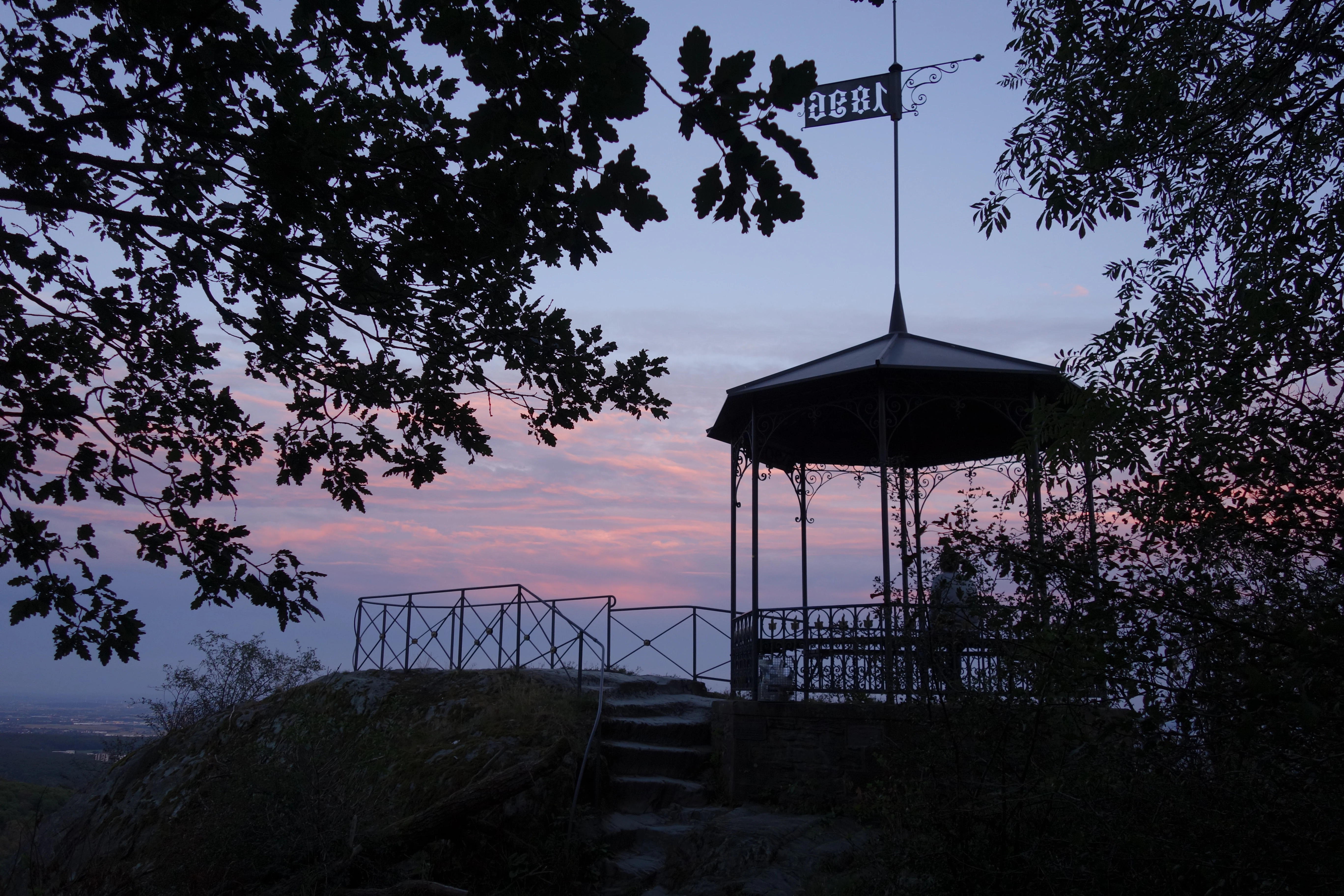
A silhouette of an ornate gazebo lookout structure with a metal roof and weather vane, set on a rocky outcrop against a colorful sunset sky, surrounded by tree branches.
The Dettweiler Temple lookout at sunset in Burghain Falkenstein.

Burghain Falkenstein history and protected-area timeline

The natural and cultural history of Burghain Falkenstein reaches back to the medieval period, when the hill first served as the site of Burg Nürings and later the more prominent Falkenstein castle. The remains of both fortifications survive within the present-day protected area, anchoring the site firmly in the regional history of the Taunus.

The area was formally placed under nature protection in 1966, recognizing the value of its surviving deciduous forest cover amid increasingly urban surroundings. In 1974, the reserve's legal framework was renewed and refined, consolidating its status as a designated Naturschutzgebiet.

In 2001, the reserve was identified as a candidate for European protection, and since 2008 it has been officially included in the Natura 2000 network as a Flora-Fauna-Habitat site. This layered protection history reflects a long-standing recognition of the site as both a local natural heritage asset and a representative example of upland beech forest in Hesse.

Burghain Falkenstein landscape and geographic character

The landscape of Burghain Falkenstein is shaped by a steep, conical hill rising above the town of Königstein. Elevations across the reserve range from roughly 380 meters at the lower edges to about 499 meters near the summit, giving the small area a striking vertical profile within the otherwise low-rise suburban setting.

The hill forms part of the broader wooded ridge country of the Hochtaunus, the northern section of the Taunus range that lies to the northwest of Frankfurt. Although the reserve itself is small, its slopes exhibit classic Taunus topography: shaded ravines, mixed slopes with varying sun exposure, and locally rocky or uneven terrain associated with the medieval castle foundations.

A defining feature of the landscape is its abrupt transition from dense urbanization to continuous forest. Built-up areas press directly against the reserve's boundary, making the woodland appear as a distinct green massif seen from the surrounding neighborhoods. From elevated points within the site, particularly the commemorative lookout known as the Dettweiler-Tempel, the view opens out across large stretches of central German landscape, including the Wetterau and the Vogelsberg to the northeast, the area of Frankfurt am Main closer at hand, the Spessart to the east, and the Odenwald to the south.
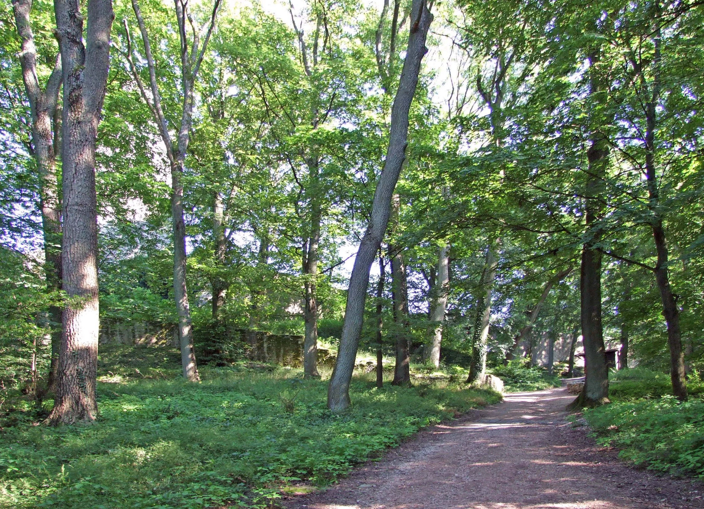
A dirt hiking trail leads into a lush, green deciduous forest at Burghain Falkenstein with dappled sunlight on the ground.
A shaded dirt path winding through the mature beech forest of Burghain Falkenstein.

Burghain Falkenstein ecosystems, habitats, and plant life

Ecologically, Burghain Falkenstein is dominated by mature deciduous forest communities typical of the central Taunus. The reserve's habitat composition reflects long continuity of woodland cover on a hill that has remained undeveloped even as surrounding areas have urbanized.

The site formally recognizes three principal habitat types as particularly worthy of protection: the Waldmeister-Buchenwald, a classic woodruff beech forest association; oak and hornbeam forest of the Labkraut-Eichen-Hainbuchenwald type; and mixed slope and ravine forests, the Schlucht- und Hangmischwälder, which thrive on the shaded, often steep terrain of the castle hill. Together, these habitats form a compact mosaic that demonstrates the natural forest patterns of the upland Taunus within a very limited area.

Because the reserve is small and fully bounded by urban development, it functions ecologically as a forest island. Its internal microclimate, soil conditions, and lack of large-scale disturbance have allowed the native woodland communities to persist in a form that contrasts strongly with the surrounding built environment. The combination of habitat integrity and geographical isolation gives the site disproportionate conservation value relative to its size.

Burghain Falkenstein wildlife and species highlights

Although the Burghain Falkenstein source material centers on habitat types rather than specific fauna, the reserve's character supports the typical animal communities of central German upland beech forest. Mature deciduous woodland with ravine and slope forest components generally provides habitat for forest-interior birds, small woodland mammals, and a diverse community of forest insects associated with dead wood and leaf litter.

For visitors and researchers, the reserve is more meaningfully understood through its habitat structure than through any species inventory. The continuity of canopy cover, the presence of older trees, and the steep slope and ravine formations create the conditions that allow woodland wildlife to persist right at the edge of an urban area.

Burghain Falkenstein conservation status and protection priorities

Burghain Falkenstein is a conservation site of layered significance. Its first formal designation as a nature reserve in 1966 marked an early recognition that small, urban-adjacent forest fragments could be ecologically valuable if their habitat character remained intact. The 1974 legal update confirmed this value, and the Natura 2000 designation, formalized in 2008, embedded the site within the European network of protected habitats.

The reserve's conservation importance lies particularly in its representation of three habitat types explicitly cited in its Natura 2000 documentation. These include woodruff beech forest, oak and hornbeam forest, and slope and ravine mixed forest, all characteristic of the natural woodland cover of the central Taunus. Protecting these habitats on a hill completely encircled by development is a meaningful act of conservation, helping to preserve biological diversity and genetic continuity in a regionally fragmented landscape.

As a small, well-managed reserve close to a major metropolitan region, Burghain Falkenstein also serves as a local illustration of how cultural and natural heritage can be preserved together on a compact site.

Burghain Falkenstein cultural meaning and human context

The cultural context of Burghain Falkenstein is unusually rich for an area of its size. The hill carries two distinct medieval fortification layers: the older Burg Nürings, of which only fragments remain, and the more prominent Falkenstein castle, whose ruins are still a recognizable feature of the landscape.

In the late 19th century, the area also acquired a commemorative cultural dimension. The Dettweiler-Tempel, built in 1896 on a rock outcrop known historically as the Teufelskanzel or Huchlay, was erected in honor of the physician Peter Dettweiler, through the combined efforts of the Frankfurt-based Taunusclub and the Falkenstein sanatorium. Its purpose was both to mark Dettweiler's contributions to the treatment of tuberculosis and to offer a structured lookout point into the broader landscape.

Other small resting and viewing structures of the same period, including the Hildatempel, the Adolftempel, and the so-called Dörches Häuschen, once accompanied the Dettweiler-Tempel in this nineteenth-century tradition of commemorative landscape architecture. Although these other structures no longer survive, their existence helps frame the hill as a place where medieval fortification, Victorian commemorative culture, and modern conservation all converge.

Top sights and standout views in Burghain Falkenstein

The Burgberg itself, with its encircling beech and oak forest, is the central highlight of the reserve. Combined with the surviving medieval castle ruins and the foundations of Burg Nürings, the site compresses several centuries of cultural and natural history into a very small area.

The Dettweiler-Tempel, listed as a cultural monument, offers one of the most expansive viewpoints in the immediate vicinity of Frankfurt, with vistas extending toward the Wetterau, Vogelsberg, Spessart, and Odenwald. The reserve's status as both a German nature reserve and a Natura 2000 site gives it a layered ecological identity that distinguishes it from many other small protected areas in the region.

Best time to visit Burghain Falkenstein

Burghain Falkenstein is best experienced during the temperate seasons, when the beech and oak forests are in leaf and the hilltop viewpoints are most rewarding. Spring brings fresh green growth and woodland bird activity, while autumn highlights the mixed deciduous canopy typical of the site. In summer, the dense forest cover provides shaded walking conditions that contrast sharply with the warmer built-up areas around the reserve. Winter visits offer clearer long-distance views from the Dettweiler-Tempel, although paths can be affected by weather conditions typical of the Taunus uplands.

Monthly climate preview

Long-term representative monthly temperature and precipitation measurements for Hessen

Burghain Falkenstein Climate Normals and Annual Temperature Rhythm

Burghain Falkenstein records measured average temperatures ranging from near freezing to warm summer maximums alongside consistent daily precipitation rates across the annual cycle. Reviewing the complete twelve-month meteorological profile provides deeper insight into long-term climate normals and regional environmental conditions.
Annual mean10 °C
0 °C21 °C
Jan
Feb
Mar
Apr10°
May14°
Jun18°
Jul21°
Aug20°
Sep15°
Oct10°
Nov
Dec
Warmest month
July

20.6 °C

Coolest month
January

0.2 °C

Wettest month
July

2.2 mm/day

Driest month
April

1.4 mm/day

Park location guide

Geography guide, regional context, and park location map for Burghain Falkenstein

Burghain Falkenstein park geography, regions, and map view in Germany

Understand where Burghain Falkenstein sits in Germany through a broader geographic reading of the surrounding landscape, nearby location context, and its mapped position within the national park landscape.

How Burghain Falkenstein fits into Germany

Germany is a federal republic in Western and Central Europe with a population of over 83 million across sixteen constituent states. It is Europe's largest economy by nominal GDP and a major global exporter and importer. The capital is Berlin, and the country borders Denmark, Poland, Czech Republic, Austria, Switzerland, France, Luxembourg, Belgium, and the Netherlands.

Wider geography shaping Burghain Falkenstein in Germany

Germany is located in Western and Central Europe, spanning 357,022 km². It borders Denmark to the north, Poland and the Czech Republic to the east, Austria and Switzerland to the south, and France, Luxembourg, Belgium, and the Netherlands to the west. The country has coastlines on the Baltic Sea and North Sea to the north, with the Alps located in the southern region.

Map view of Burghain Falkenstein

Use this park location map to pinpoint Burghain Falkenstein in Germany, understand its exact geographic position, and read its mapped placement within the surrounding landscape more clearly.

Pigeon | © OpenStreetMap contributors

Location context for Burghain Falkenstein

Hessen
Recorded earthquake history

Explore the Historical Earthquake Records for Burghain Falkenstein

Navigate to the comprehensive catalogue of recorded seismic events associated with the geography of Burghain Falkenstein. This collection provides clear historical data regarding event magnitudes and proximity, serving as a valuable resource for anyone tracking regional seismic history through MoriAtlas.

Burghain Falkenstein Earthquake History

Catalogued events

27 events

Strongest magnitude

Magnitude 4.3

Most recent event

May 17, 2014

This history includes earthquakes recorded inside the park or within 50 km of its borders

Visual reference collection showcasing the Taunus upland terrain and deciduous woodland habitats.

Burghain Falkenstein Photos, Landscape Scenery, and Protected Forest Views

Visual documentation captures the steep topography, medieval castle ruins, and dense beech woodlands defining the protected reserve. Detailed photographic coverage reveals the unique urban-adjacent forest environment and elevated ridge viewpoints across the landscape.

A silhouette of an ornate gazebo lookout structure with a metal roof and weather vane, set on a rocky outcrop against a colorful sunset sky, surrounded by tree branches.

An expansive, elevated landscape view overlooking a forested hill, the ruins of Falkenstein Castle, and a residential area nestled in the valley, with a distant city skyline under a clear blue sky.

A dirt hiking trail leads into a lush, green deciduous forest at Burghain Falkenstein with dappled sunlight on the ground.

Park atlas

Discover adjacent nature reserves and regional woodland habitats across the Taunus uplands

Explore Other Parks Near Burghain Falkenstein and Surrounding Protected Areas

Compare Burghain Falkenstein with other protected areas located throughout the surrounding Taunus range and nearby German uplands. Examining adjacent woodland reserves reveals broader ecological patterns and connects individual forest islands to regional conservation geography.
Nature reserveHessen
4.3 km away#1 closest

Southwest

Krebsbachtal bei Ruppertshain: Protected Stream Valley and Conservation Geography

Nature reserve and FFH site in the Hessian Taunus

Located in the western foothills of the Taunus, Krebsbachtal bei Ruppertshain is a protected nature reserve and Natura 2000 site. It features a linear valley landscape defined by the Fischbach stream corridor and dense mixed deciduous forest. The reserve plays a crucial role in maintaining regional ecological continuity within the Rhine-Main area, providing a distinct geographic boundary near the Rossert massif.

Area
0.845 km²
Established
1992
IUCN
IV
Relief
Upland
A soft, impressionistic watercolor painting of a meadow with wildflowers in the foreground, rolling hills and trees in the midground, and a faint mountain range in the background.
Nature reserveHochtaunuskreis
About 5.1 km away#2 closest

Northwest

Reifenberger Wiesen Nature Reserve: Geographic Profile and Protected Meadow Boundaries

High Taunus mountain meadows within the Hochtaunuskreis region.

Located in the High Taunus mountains, Reifenberger Wiesen provides a concentrated example of mountain hillside meadows. This nature reserve features specialized nutrient-poor grasslands that host diverse botanical communities, supported by its distinct north-facing slope geography and proximity to the headwaters of the Weil river, forming a critical ecological link in the Hessian landscape.

Area
0.234 km²
Established
1983
A soft watercolor painting depicting rolling green hills and a forested landscape under a pale, sunrise-hued sky.
Nature reserveHessen
5.5 km away#3 closest

Southwest

Rossert - Hainkopf - Dachsbau Nature Reserve: Geography and Protected Taunus Forest Landscapes

A preserved ridge system in the Hessen region of Germany

The Rossert - Hainkopf - Dachsbau nature reserve represents a compact but ecologically vital ridge system in the Taunus foothills. Spanning over 120 hectares of mixed forest, this protected area preserves the transition between woodland and open meadow while securing the headwaters of the Wellbach stream within its geographic boundaries.

Area
1.19 km²
Established
1977
IUCN
IV
A watercolor illustration of a serene valley landscape with a small winding stream running through grassy meadows, bordered by trees in the distance.
Nature reserveHesse
About 8.4 km away#4 closest

West

Dattenbachtal zwischen Kröftel und Vockenhausen Nature Reserve in Hesse, Germany

Stream valley and protected riparian landscape mapping

This nature reserve protects a vital section of the Dattenbach stream valley between the villages of Kröftel and Vockenhausen. Spanning cross-district boundaries in the Taunus foothills, the site is defined by its two-parcel structure and its role in preserving headwater stream habitats within the larger Hessian landscape.

Area
0.909 km²
Established
1993
Watercolor painting depicting a landscape with rolling hills in the background and trees in autumn colors in the midground.
Nature reserveHochtaunuskreis
About 9.9 km away#5 closest

North

Saubach und Niedgesbach bei Schmitten Nature Reserve: High Taunus Landscape Geography

Mapped protected valleys in the Hochtaunuskreis region.

This nature reserve protects the parallel stream valleys of the Saubach and Niedgesbach near the village of Schmitten. The site is a significant example of High Taunus upland ecology, where abandoned pastoral land has fostered unique plant diversity. It remains a key focal point for understanding the transition of cultural landscapes into protected wild habitats within the Hochtaunuskreis.

Area
0.58 km²
Established
1995
A watercolor painting showing rolling green meadows, trees, and soft distant hills against a white background.
Nature reserveHessen
10 km away#6 closest

Northeast

Kirdorfer Feld bei Bad Homburg: Protected Cultural Landscape and Meadow Reserve Map

Nature reserve and Natura 2000 protected land in Hessen

Kirdorfer Feld bei Bad Homburg serves as a prime example of an intact agricultural cultural landscape, defined by its traditional Streuobstwiesen orchards, damp meadow corridors, and spring-fed wetlands. This site acts as a key ecological anchor within the Taunus foothills, showcasing a unique interplay between managed farmland and protected botanical communities. Learn about the geographic composition of this designated Natura 2000 site.

Area
1.6 km²
Established
1996
Relief
Lowland
Scope
Terrestrial
A soft, horizontal watercolor painting depicting green rolling hills and wetland vegetation.
Nature reserveHessen
About 12 km away#7 closest

East

Riedwiesen Nature Reserve: Mapped Protected Wet Meadow Landscapes in Hessen, Germany

A critical fragment of floodplain ecology within the Frankfurt Grüngürtel

Riedwiesen serves as a protected nature reserve, preserving 20 hectares of wet meadow habitat along the Nidda river. This site highlights the intersection of urban infrastructure and resilient floodplain geography, providing a refuge for characteristic amphibians and wetland vegetation within the Hessen landscape.

Area
0.205 km²
Established
1983
IUCN
IV
Nature reserveHesse
About 13 km away#8 closest

Southwest

Prügelwiesen bei Wiesbaden in Breckenheim: Protected Fen and Meadow Nature Reserve

Mapped landscapes and wetland conservation in Hesse, Germany

Prügelwiesen bei Wiesbaden in Breckenheim preserves a diverse wetland ecosystem featuring calcareous fens, sedge beds, and traditional orchard meadows. Located in the Rhine-Main region, this nature reserve offers a look into rare grassland communities and groundwater-dependent habitats that characterize the transition between the Taunus foothills and the Main lowlands.

Area
0.079 km²
Established
1994
IUCN
IV
Relief
Lowland

Common questions about visiting, size, designation, and location context for Burghain Falkenstein

Burghain Falkenstein FAQs for park facts, access, geography, and protected area context

Find quick answers about Burghain Falkenstein, including protected-area facts, park geography, trail and visitor context, and how the park fits into its surrounding country and regional landscape.
MoriAtlas Explorer

Continue Your Protected Areas Search Across the Global Atlas

Deepen your exploration by continuing the structured search for national parks and protected areas worldwide. Utilize the comprehensive filtering capabilities to compare different conservation landscapes and refine your understanding of global park geography. Discover more about the distribution and characteristics of protected natural areas.

Global natural geography