

Mori Atlas logo
Nature reserveCalpatanna Waterhole Conservation Park

Discover the geographic intersection of seasonal saline lagoons and semi-arid mallee eucalyptus scrubland

Calpatanna Waterhole Conservation Park: Mapping the Protected Landscapes of South Australia

Calpatanna Waterhole Conservation Park protects a unique coastal hinterland environment on the Eyre Peninsula of South Australia. Spanning roughly 36 square kilometres, this nature reserve serves as a critical site for understanding the interaction between ephemeral saline wetland systems and the surrounding mallee eucalyptus and Melaleuca vegetation communities. The park preserves a representative landscape of the state's west coast, offering significant insight into the terrain patterns and ecological zones characteristic of this semi-arid region.

Eyre PeninsulaSouth Australiasemi-arid scrubsaline lagoonsseasonal wetlandsmallee eucalyptus

Calpatanna Waterhole Conservation Park

Nature reserve

Park overview

Structured park overview, official facts, and landscape profile for Calpatanna Waterhole Conservation Park

Calpatanna Waterhole Conservation Park park facts, protected area profile, and essential visitor context

Review the core facts for Calpatanna Waterhole Conservation Park, including designation, size, terrain, visitor scale, habitats, and operating context in one park-focused overview.

About Calpatanna Waterhole Conservation Park

Calpatanna Waterhole Conservation Park is a relatively compact but ecologically significant reserve in the semi-arid west of the Eyre Peninsula in South Australia. Although small in area, the park protects a striking mosaic of habitats centered on the Calpatanna Waterhole itself, an inland waterbody whose seasonal behavior shapes much of the reserve's character. The park was established in 1974 and has since remained one of the more focused conservation reserves in the region, dedicated to preserving representative vegetation from the South Australian west coast.

The park's geography combines gently undulating terrain of typical Eyre Peninsula mallee country with shallow seasonal saline lagoons. These lagoons are not permanent in the way that larger inland lakes are, but instead fill and then gradually evaporate depending on winter rainfall, producing a shifting, dynamic ecological environment. The cyclical wetting and drying of these systems creates transition zones between aquatic, saline, and terrestrial habitats that support a wider range of plant and animal life than the surrounding dry scrub alone would.

The broader context of the park is the Eyre Peninsula's coastal semi-arid zone, a region defined by low rainfall, limestone-influenced soils, and a distinctive mix of mallee eucalypts, paperbarks, and salt-tolerant shrublands. Within this regional setting, Calpatanna Waterhole Conservation Park stands out as a reserve that captures both the dry sclerophyll vegetation of the dunes and rises and the more specialized wetland vegetation of the saline flats. Its protected status, combined with its relatively undisturbed condition following the end of past grazing, makes it a useful benchmark for understanding the natural vegetation of this part of South Australia.

Quick facts and research context for Calpatanna Waterhole Conservation Park

Calpatanna Waterhole Conservation Park is a small protected area on the Eyre Peninsula in South Australia, situated between the localities of Calca, Mortana and Yanerbie and centered on the Calpatanna Waterhole itself. The park lies in the semi-arid west coast region of South Australia, roughly 25 kilometres south-east of the town of Streaky Bay.

The reserve covers approximately 36.44 square kilometres and was proclaimed on 14 February 1974 under South Australia's National Parks and Wildlife Act 1972, with later additions in 1985. It is classified as an IUCN Category Ia strict nature reserve and was listed on the former Register of the National Estate in 1980, reflecting its conservation significance as a representative example of west coast South Australian vegetation.

Protection and recognition

Terrestrial protected area designation and international recognition history

Calpatanna Waterhole Conservation Park Protection Status and Scope

Documented protection status records outline the terrestrial management scope and designated parameters established for Calpatanna Waterhole Conservation Park. Verified administrative details establish baseline conservation frameworks without international recognition sources.

Protection details

Protection scope
Terrestrial
Transboundary protection
No
Park context

Deeper park guide and search-rich context for Calpatanna Waterhole Conservation Park

Calpatanna Waterhole Conservation Park history, landscape, wildlife, and travel context

Explore Calpatanna Waterhole Conservation Park through its history, landscape character, ecosystems, wildlife, conservation priorities, cultural context, and seasonal travel timing in a structured park guide built for atlas discovery and search intent.

Why Calpatanna Waterhole Conservation Park stands out

Calpatanna Waterhole Conservation Park is best known for its seasonal saline lagoons, which fill with winter rains and form the dominant landscape feature of the reserve. The lagoons support Melaleuca halmaturorum tall shrubland, a distinctive vegetation community along the South Australian west coast. The park is also recognized for preserving a representative example of semi-arid mallee scrub dominated by Eucalyptus diversifolia, accompanied by other eucalypt species such as E. socialis and E. gracilis. Together, the saline wetland system and the surrounding mallee and Melaleuca vegetation give the park its strong ecological identity within the Eyre Peninsula landscape.

Calpatanna Waterhole Conservation Park history and protected-area timeline

Calpatanna Waterhole Conservation Park was proclaimed on 14 February 1974 under South Australia's National Parks and Wildlife Act 1972, the state's primary legislation for the protection of native flora, fauna, and natural landscapes. The initial proclamation covered land in designated sections within the Hundred of Wrenfordsley, a cadastral unit used to organize land administration in this part of the Eyre Peninsula.

On 16 July 1985, additional land in adjoining sections was added to the conservation park, modestly expanding its footprint. By July 2016, the total area of the reserve was recorded as 36.44 square kilometres, an indication that the park has remained a relatively small but deliberate conservation holding rather than a large landscape-scale reserve.

In 1980, the park was formally assessed and described as a moderately large area preserving semi-arid scrub representative of the west coast region of South Australia, with the assessment also noting some prior grazing history. That same year, the conservation park was listed on the now-defunct Register of the National Estate, a recognition of its heritage and ecological significance at the national level. The reserve continues to be managed as a high-protection conservation area, classified as an IUCN Category Ia strict nature reserve.

Calpatanna Waterhole Conservation Park landscape and geographic character

The landscape of Calpatanna Waterhole Conservation Park is shaped by the semi-arid character of South Australia's west coast. The terrain is generally low and gently undulating, typical of the Eyre Peninsula's coastal hinterland, where limestone and calcareous soils support specialised vegetation adapted to dry conditions and salt exposure.

The dominant physical feature inside the park is an extensive network of seasonal saline lagoons. These shallow depressions fill with water during the cooler, wetter winter months and then progressively dry out as the warmer months advance, leaving exposed saline flats. The seasonal rhythm of the lagoons produces a distinctive visual and ecological landscape, alternating between reflective water surfaces and pale, salt-encrusted ground throughout the year.

Surrounding the lagoons, the park rises into mallee scrub country, with dune and rise vegetation dominated by multi-stemmed eucalypts and a sparse, hardy understorey. The combination of open lagoons, vegetated flats, and mallee slopes creates a varied topography within a relatively compact area, giving the reserve a sense of landscape diversity uncommon for parks of its size in the region.

Calpatanna Waterhole Conservation Park ecosystems, habitats, and plant life

Ecologically, Calpatanna Waterhole Conservation Park falls within the semi-arid west coast bioregion of South Australia, a zone characterized by low and highly variable rainfall, calcareous soils, and vegetation communities adapted to both drought and periodic salt accumulation. The reserve protects a representative cross-section of these conditions, making it ecologically valuable as a reference site for the region's natural vegetation.

A central ecological feature is the association between the seasonal saline lagoons and the Melaleuca halmaturorum tall shrubland that grows around them. This paperbark-dominated community is well suited to the alternating wet and saline conditions of the lagoon margins and contributes significantly to the botanical diversity of the park.

The principal vegetation association across the broader park, however, is a mallee scrub dominated by Eucalyptus diversifolia, often growing alongside E. socialis, E. gracilis, Melaleuca lanceolata, and Exocarpus species. The 1980 reserve description noted that, despite a history of grazing, the park remained in good condition and was regarded as generally representative of the regional vegetation, indicating that its ecological integrity has largely been maintained through several decades of protected management.

Calpatanna Waterhole Conservation Park wildlife and species highlights

The wildlife profile of Calpatanna Waterhole Conservation Park is closely tied to its mosaic of saline lagoons, Melaleuca shrublands, and mallee scrub. The seasonal filling and drying of the lagoons creates temporary habitat for waterbirds and other fauna adapted to fluctuating wetland conditions, while the surrounding mallee and paperbark communities support the typical suite of small reptiles, mammals, and passerine birds associated with south Australian semi-arid scrub.

The botanical diversity driven by the saline-wetland transition has been highlighted as a key driver of faunal diversity in the park. Plant communities like the Melaleuca tall shrubland, combined with mallee eucalypts and assorted understorey species, provide varied shelter and foraging opportunities across a relatively compact area.

Although the original park description does not enumerate individual species, its classification as a strict nature reserve and its inclusion on the Register of the National Estate reflect recognition of its broader wildlife significance. The park's value lies less in charismatic large species and more in its role as an intact representation of the ecological communities that define the Eyre Peninsula's west coast.

Calpatanna Waterhole Conservation Park conservation status and protection priorities

From a conservation perspective, Calpatanna Waterhole Conservation Park is significant primarily because it preserves a representative example of the semi-arid vegetation of South Australia's west coast in relatively good condition. The park's combination of seasonal saline lagoons, Melaleuca shrubland, and mallee scrub captures several key ecological elements of the region within a single managed boundary, making it a useful reference area for conservation science and monitoring.

The reserve is managed under the highest level of international protection recognized in Australia, classified as an IUCN Category Ia protected area, indicating that it is managed as a strict nature reserve with a primary focus on biodiversity conservation. This status implies strong limitations on activities that could disturb the ecological values of the area.

In 1980, the park was listed on the Register of the National Estate, a recognition of its heritage and ecological importance at a national scale. While the Register itself is no longer active, the listing is a historical marker of the park's recognized conservation value. The 1980 assessment also emphasized that, despite some prior grazing history, the vegetation of the park was in good condition and continued to reflect the natural state of the surrounding region, underscoring its ongoing conservation relevance.

Top sights and standout views in Calpatanna Waterhole Conservation Park

Calpatanna Waterhole Conservation Park's most distinctive quality is its extensive system of seasonal saline lagoons, which fill with winter rains and support Melaleuca halmaturorum tall shrubland around their margins.

The park is equally notable for its mallee scrub dominated by Eucalyptus diversifolia, which, together with associated eucalypt and Exocarpus species, is considered representative of the broader west coast vegetation of South Australia. As an IUCN Category Ia strict nature reserve, it combines strong protection status with an ecological character shaped by both wetland and dryland habitats in a compact Eyre Peninsula setting.

Best time to visit Calpatanna Waterhole Conservation Park

The character of a visit to Calpatanna Waterhole Conservation Park shifts with the seasons in ways that reflect its semi-arid wetland ecology. Winter and early spring, when the saline lagoons fill with seasonal rains, tend to be the most visually distinctive period, as the reserve transitions into its wetland phase and waterbirds may be more concentrated around the flooded areas.

Late spring through autumn generally brings drier conditions, with the lagoons gradually contracting and the mallee and Melaleuca vegetation dominating the landscape. These drier months can offer clearer wildlife observation in the scrub communities and a stronger sense of the park's semi-arid identity, though the saline flats become more prominent as the water recedes. Visitors interested in the park's lagoon-based character will find the cooler, wetter months most rewarding, while those focused on mallee scrub vegetation may prefer the warmer, drier season.
Monthly climate preview

Examine long-term monthly temperature averages and precipitation measurements for South Australia.

Calpatanna Waterhole Conservation Park Climate Normals and Temperature Patterns

Representative coordinate records show measured monthly temperature ranges alongside baseline precipitation levels throughout the annual cycle at Calpatanna Waterhole Conservation Park. Detailed twelve-month climate profiles provide complete statistical context for long-term meteorological research across protected landscapes.
Annual mean17 °C
13 °C22 °C
Jan22°
Feb22°
Mar20°
Apr18°
May16°
Jun14°
Jul13°
Aug13°
Sep15°
Oct17°
Nov19°
Dec20°
Warmest month
February

21.9 °C

Coolest month
July

12.7 °C

Wettest month
July

1.5 mm/day

Driest month
January

0.4 mm/day

Park location guide

Geography guide, regional context, and park location map for Calpatanna Waterhole Conservation Park

Calpatanna Waterhole Conservation Park park geography, regions, and map view in Australia

Understand where Calpatanna Waterhole Conservation Park sits in Australia through a broader geographic reading of the surrounding landscape, nearby location context, and its mapped position within the national park landscape.

How Calpatanna Waterhole Conservation Park fits into Australia

Australia is a constitutional monarchy and federal parliamentary democracy comprising six states and ten territories. With a population of nearly 28 million, it is one of the world's most urbanised countries, with most people concentrated on the eastern seaboard. The country has a high Human Development Index and is known for its cultural diversity, ancient Aboriginal heritage, and unique wildlife.

Wider geography shaping Calpatanna Waterhole Conservation Park in Australia

Australia occupies the entire Australian continent, the island of Tasmania, and numerous smaller islands. It is the world's flattest and driest inhabited continent, featuring vast deserts in the interior (the Outback), tropical rainforests along the eastern coast, and a coastline bordering the Indian and Pacific Oceans.

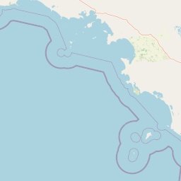
Map view of Calpatanna Waterhole Conservation Park

Use this park location map to pinpoint Calpatanna Waterhole Conservation Park in Australia, understand its exact geographic position, and read its mapped placement within the surrounding landscape more clearly.

Pigeon | © OpenStreetMap contributors

Location context for Calpatanna Waterhole Conservation Park

South Australia
Park atlas

Compare regional protected areas, coastal mallee scrub, and surrounding wetland terrain

Parks Near Calpatanna Waterhole Conservation Park and Protected Landscapes in South Australia

Browsing other protected areas near Calpatanna Waterhole Conservation Park reveals connected coastal ecosystems across the Eyre Peninsula. Continuing through related reserves provides deeper geographic context into the semi-arid mallee scrub and seasonal wetland habitats of South Australia.
Protected areaSouth Australia
About 15 km away#1 closest

West

Cape Blanche Conservation Park: Eyre Peninsula Coastal Protected Landscape Map

Regional geography and conservation coastal terrain

Located on the remote western coast of the Eyre Peninsula, Cape Blanche Conservation Park serves as a dedicated sanctuary for coastal raptors and migratory birds. This protected area features a rugged intersection of limestone cliffs, sandy bays, and native coastal flora, providing an essential ecological corridor within the South Australian reserve system.

Area
810 km²
Established
2012
IUCN
III
Scope
Terrestrial
Nature reserveSouth Australia
About 35 km away#2 closest

North

Eba Island Conservation Park: Coastal Landforms and Nature Reserve Geography in South Australia

A protected offshore sanctuary within Streaky Bay's coastal landscape.

Eba Island Conservation Park represents a key protected area within the coastal geography of South Australia. Composed primarily of calcarenite and limestone, the reserve features a diverse range of coastal landforms, including rugged jagged ridges, active blowholes, and sheltered coves, providing an essential habitat for seabird colonies.

Area
1.34 km²
Established
1966
IUCN
Ia
Relief
Lowland
Wildlife reserveSouth Australia
About 74 km away#3 closest

Northeast

Gawler Ranges Conservation Park: Mallee Landscapes and Regional Protected Areas

Semi-arid habitat and rocky terrain of South Australia

Gawler Ranges Conservation Park protects a core area of tree mallee woodland and rocky rises near the southern fringe of the Gawler Ranges. This wildlife reserve serves as an essential anchor for regional biodiversity on the Eyre Peninsula, offering a look at the arid-adapted vegetation and weathered geological structures that define this remote section of South Australia.

Area
154.8 km²
Established
1993
IUCN
VI
Relief
Upland
National parkSouth Australia
About 90 km away#4 closest

Northeast

Gawler Ranges National Park: South Australia's Mapped Protected National Landscape

Explore the geography and protected area context of this national park.

Gawler Ranges National Park stands as a significant protected area within the geographic expanse of South Australia. Designated as a national park, it offers valuable insights into Australia's conservation landscapes and regional geography. Users can explore its mapped boundaries and understand its unique role within the national park system, making it a key point for structured geographic study and atlas-based discovery of protected lands.

Area
1,628.75 km²
Established
2002
IUCN
VI
Relief
Mountain
Wildlife reserveSouth Australia
About 90 km away#5 closest

East

Cocata Conservation Park: Eyre Peninsula Protected Wildlife Reserve and Landscape Map

Geographic overview of South Australian conservation lands.

Cocata Conservation Park encompasses a vast semi-arid expanse on the Eyre Peninsula, characterized by gently undulating plains, calcrete-capped terrain, and open salt flats. Gain insights into the physical geography and habitat distribution of this important South Australian wildlife reserve through detailed regional mapping.

Area
167.62 km²
Established
1993
IUCN
VI
Scope
Terrestrial
Wildlife reserveSouth Australia
About 103 km away#6 closest

Southeast

Dakalanta Sanctuary: A Private Wildlife Reserve on the Northern Eyre Peninsula

Mapped regional geography and conservation habitat profiles

Dakalanta Sanctuary provides a significant example of private land conservation in South Australia. Covering 130 square kilometres of low hills and stabilized dunes, this reserve focuses on restoring native vegetation after past pastoral use. The area is vital for safeguarding semi-arid habitats like mallee woodlands, playing an active role in regional biodiversity protection and habitat connectivity.

Area
130 km²
Established
2002
Relief
Upland
Access
Access unknown
Nature reserveSouth Australia
About 128 km away#7 closest

Southeast

Cap Island Conservation Park: Nature Reserve and Offshore Marine Habitat in South Australia

Coastal granite island and protected seabird breeding landscape.

Situated off the coast of the Eyre Peninsula, Cap Island Conservation Park is a protected nature reserve serving as a critical sanctuary for pinnipeds and nesting seabirds. Its unique geological profile, featuring a granite base and calcarenite cap, creates a rugged offshore environment shaped by marine erosion and salt-tolerant vegetation. The reserve highlights the significance of isolated island ecosystems within the broader geography of South Australia.

Area
0.09 km²
Established
1967
IUCN
Ia
Relief
Lowland
State or regional parkSouth Australia
About 131 km away#8 closest

East

Corrobinnie Hill Conservation Park: Mapped Protected Landscapes and Geological Features

A remote conservation site on the Eyre Peninsula

Corrobinnie Hill Conservation Park protects an exceptional granite outcrop that stands as a natural monument within the South Australian landscape. The site is characterized by its weathered rock formations and its geographic connection to the broader Pinkawillinie conservation estate, offering insight into the geological diversity of remote Eyre Peninsula pastoral country.

Area
2.08 km²
Established
1983
IUCN
III
Relief
Upland

Common questions about visiting, size, designation, and location context for Calpatanna Waterhole Conservation Park

Calpatanna Waterhole Conservation Park FAQs for park facts, access, geography, and protected area context

Find quick answers about Calpatanna Waterhole Conservation Park, including protected-area facts, park geography, trail and visitor context, and how the park fits into its surrounding country and regional landscape.
MoriAtlas Explorer

Continue Your Protected Areas Search Across the Global Atlas

Deepen your exploration by continuing the structured search for national parks and protected areas worldwide. Utilize the comprehensive filtering capabilities to compare different conservation landscapes and refine your understanding of global park geography. Discover more about the distribution and characteristics of protected natural areas.

Global natural geography