
Why Cape Jourimain National Wildlife Area stands out
Cape Jourimain is best known for its concentration of migratory bird habitat along one of eastern Canada's most strategic migratory corridors. Positioned where the Confederation Bridge crosses to Prince Edward Island, the reserve sits at a natural gathering point for waterfowl, shorebirds, and songbirds moving along the Atlantic and Gulf of St. Lawrence flyways. Its mix of salt marshes, freshwater wetlands, and brackish systems, combined with fragile coastal dune and shoreline habitat, gives the area its particular ecological value. The presence of the piping plover, a species at risk, adds a conservation focus that distinguishes Cape Jourimain from many other coastal wildlife sites in the Maritimes.
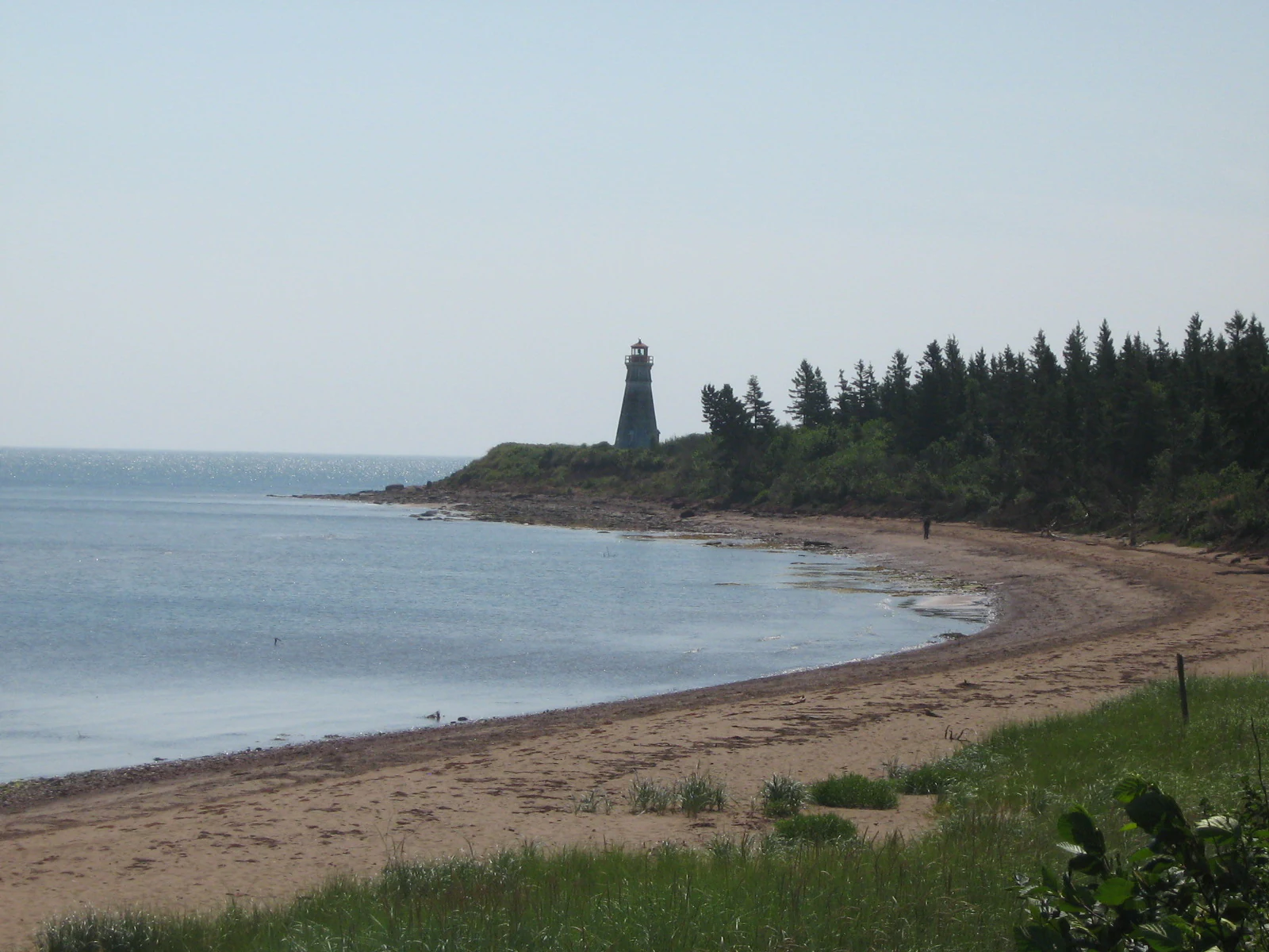
Cape Jourimain National Wildlife Area history and protected-area timeline
Cape Jourimain National Wildlife Area was established on 25 June 1980 as part of Canada's expanding federal network of National Wildlife Areas dedicated to the strict protection of habitat and species. From the outset, it was placed under the administration of Environment and Climate Change Canada through the Canadian Wildlife Service, aligning it with other coastal and migratory bird reserves along the Atlantic and Gulf of St. Lawrence shores.
By 2002, the reserve's role had broadened beyond strict conservation. On 26 July 2002, the Cape Jourimain Nature Interpretation Centre was officially opened by the Honourable Marilyn Trenholme Counsell, then Lieutenant Governor of New Brunswick, adding an educational and visitor-engagement dimension to what had previously been a primarily habitat-protection site.
The reserve's physical infrastructure also has its own history. In the 1960s, a causeway was built linking the two islands within the reserve's territory to the mainland, transforming the accessibility of the site and shaping how its habitats and shoreline respond to tidal and human influences. The rugged, changeable character of the surrounding coast, where salt marshes, dune systems, and shallow marine areas continue to shift over time, remains a defining element of the reserve's identity.
Cape Jourimain National Wildlife Area landscape and geographic character
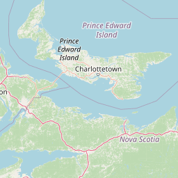
The landscape of Cape Jourimain is shaped by its position at the Abegweit Passage, the narrowest stretch of the Northumberland Strait, where currents, tides, and seasonal ice have built up a complex mosaic of islands, marshes, and shoreline. The reserve comprises two principal islands, the centrally located Trenholm Island and the surrounding Jourimain Island, connected to the mainland and to each other by brackish marshes and a causeway constructed in the 1960s.
Beneath the surface, the geology reflects two distinct formations. The Tormentine Formation underlies the islands and the adjacent coastline, with red sandstone, conglomerate, and some mudstone dating back toward the late Paleozoic. Inland, the Richibucto Formation appears, composed of orange to grey sandstone, mudstone, conglomerate, and Pennsylvanian-age coal, representing sedimentary environments between roughly 299 and 318 million years old.
Above ground, the scenery is defined by a soft, salt-edged coast rather than dramatic cliffs. Salt marshes fringe the tidal waters, freshwater marshes occupy quieter inland pockets, and brackish wetlands form broad transition zones. The shoreline is fragile and continually changing, with shifting sands, tidal flats, and low coastal relief that together produce the open, breezy character typical of Northumberland Strait landscapes.
Cape Jourimain National Wildlife Area ecosystems, habitats, and plant life
Ecologically, Cape Jourimain is a meeting point of marine, brackish, and freshwater environments compressed into a relatively small island-and-marsh complex. The reserve protects salt marshes along its tidal edges, freshwater marshes in sheltered interior depressions, and brackish marshes where saline and fresh waters mix. The result is a layered habitat structure that supports a wide diversity of invertebrates, plants, and vertebrates within a compact coastal footprint.
The marine component is significant: roughly half of the reserve's 662-hectare area is marine, linking the shoreline habitats to the broader Northumberland Strait ecosystem. Shallow tidal flats and sheltered embayments around the islands provide feeding areas for wading birds and waterfowl, while the marshes themselves serve as nesting cover, foraging habitat, and seasonal refuge.
Vegetation patterns follow the salinity gradient. Salt-tolerant grasses and succulent marsh plants dominate the tidal edges, while reeds, sedges, and other freshwater and brackish species colonize the more sheltered interior. The combination of tidal inputs, seasonal freshwater flows, and exposed coastal dunes produces a habitat mosaic that shifts subtly with the seasons and the long-term evolution of the shoreline.
Cape Jourimain National Wildlife Area wildlife and species highlights
Wildlife is the central identity of Cape Jourimain. The reserve is best understood as a migratory bird habitat of regional importance, with roughly 170 species of migratory birds recorded using the site across the year. These include waterfowl, shorebirds, waders, and a wide range of songbirds that rely on the Northumberland Strait's shoreline as a stopover, breeding, or wintering area.
Among these species, the piping plover stands out as a particular focus for conservation. Listed as a species at risk, the piping plover depends on the open sandy shoreline and coastal flats the reserve protects, making Cape Jourimain part of a broader effort to maintain breeding and foraging habitat for this vulnerable shorebird along the Gulf of St. Lawrence.
The reserve's mix of marshes and tidal flats also supports a broader community of shorebirds and waterfowl during migration, when flocks concentrate along the Abegweit Passage. Inland portions, with freshwater and brackish marsh elements, provide habitat for additional birdlife and small vertebrates, while the surrounding marine waters sustain fish and invertebrate populations that anchor the food web of the entire reserve.
Cape Jourimain National Wildlife Area conservation status and protection priorities
Cape Jourimain's conservation significance lies in its role as a strictly protected federal National Wildlife Area at a strategic point along the migratory corridors of eastern Canada. By guarding salt marshes, freshwater wetlands, and brackish systems at the narrowest point of the Northumberland Strait, the reserve preserves habitat continuity in a region where coastal development, shoreline alteration, and climate-driven changes put pressure on natural systems.
The reserve's IUCN Category IV designation underscores its focus on habitat and species management rather than broader landscape protection. Its establishment in 1980 placed it within Canada's network of 143 National Wildlife Areas, where lands are managed for wildlife conservation with limited public access.
A particularly important element of the reserve's conservation profile is its role for the piping plover and other migratory shorebirds. By protecting nesting beaches, tidal flats, and adjacent marshes from more intensive human use, the reserve helps sustain the ecological conditions that these species depend on during the most sensitive parts of their annual cycle. The presence of the Cape Jourimain Nature Interpretation Centre also contributes to conservation awareness, connecting habitat protection with public understanding of the area's ecological value.
Cape Jourimain National Wildlife Area cultural meaning and human context
Cape Jourimain sits within a coastal region of southeastern New Brunswick long shaped by its relationship with the sea. The reserve's location at the Abegweit Passage, near Cape Tourmentin, places it at a historic crossing point between New Brunswick and Prince Edward Island, a place long associated with ferry traffic before the Confederation Bridge era.
The opening of the Cape Jourimain Nature Interpretation Centre in 2002, with the Honourable Marilyn Trenholme Counsell presiding as Lieutenant Governor of New Brunswick, marked a moment of formal recognition for the area's ecological and educational value within the province. Today, the interpretive centre and the surrounding reserve together reflect a deliberate effort to integrate wildlife conservation with local heritage and community engagement along this stretch of the Northumberland Strait.
Top sights and standout views in Cape Jourimain National Wildlife Area
Cape Jourimain stands out for the compactness and diversity of its protected coastal ecosystems, where salt, brackish, and freshwater marshes meet the open waters of the Northumberland Strait. Its position at the country's narrowest sea crossing concentrates migratory bird activity and gives the reserve an outsized ecological role for its size.
The protected area's value is reinforced by its inclusion in Canada's National Wildlife Area network, its piping plover habitat, and the presence of the Cape Jourimain Nature Interpretation Centre, which links conservation directly to public learning. The reserve's combination of active habitat protection, ongoing geological and shoreline change, and a strong bird-focused identity gives it a distinctive profile among eastern Canadian coastal protected areas.
Best time to visit Cape Jourimain National Wildlife Area
Cape Jourimain's character shifts noticeably with the seasons, and the timing of a visit is closely tied to what visitors hope to experience. Spring and early summer bring peak migratory bird activity, when shorebirds, waterfowl, and songbirds concentrate along the marshes and tidal flats, and when nesting species such as the piping plover are most sensitive to shoreline disturbance.
Summer is generally the most accessible period for visitors using the Cape Jourimain Nature Interpretation Centre, when weather along the Northumberland Strait is mildest and the marshes are biologically most active. Late summer and early autumn bring post-breeding bird movements and rich marsh vegetation, while winter reveals a quieter, more austere coastal landscape shaped by wind, ice, and shifting light across the Abegweit Passage.