

Mori Atlas logo
Protected areaCarribie Conservation Park

Analyzing the vegetation boundaries and landscape terrain of this southern Yorke Peninsula conservation site

Carribie Conservation Park: A Mapped Protected Area and Ecological Reference in South Australia

Carribie Conservation Park functions as a critical ecological reference site on the Yorke Peninsula of South Australia. Spanning an undulating sandy plain, the park protects two distinct native vegetation associations; dense mallee scrub dominated by Eucalyptus diversifolia in the north and an open woodland of Casuarina stricta and Melaleuca lanceolata in the south. This protected area represents an essential remnant of original regional terrain amidst a largely cleared agricultural landscape.

conservation parkYorke PeninsulaSouth Australiamallee scrubwoodlandnative vegetation remnant

Carribie Conservation Park

Protected area

Park overview

Structured park overview, official facts, and landscape profile for Carribie Conservation Park

Carribie Conservation Park park facts, protected area profile, and essential visitor context

Review the core facts for Carribie Conservation Park, including designation, size, terrain, visitor scale, habitats, and operating context in one park-focused overview.

About Carribie Conservation Park

Carribie Conservation Park is a compact conservation reserve located on the southern Yorke Peninsula of South Australia, in the locality of Corny Point and a short distance inland from the coastline. Although small in scale, the park plays a particular ecological role because the greater Yorke Peninsula has been extensively cleared for farming and settlement, leaving only scattered fragments of the region's original vegetation. Carribie Conservation Park is one of those fragments, and its value lies as much in what it represents of the broader landscape as in its own internal character.

The park occupies an undulating sandy plain and contains two distinct vegetation associations that occur side by side. In the north, a dense mallee scrub dominated by Eucalyptus diversifolia forms a low, multi-stemmed woodland typical of the more arid parts of southern Australia. In the southern part of the park, the vegetation shifts to a taller, more open woodland dominated by sheoak (Casuarina stricta) and dryland tea-tree (Melaleuca lanceolata). These two associations together are regarded as representative of the original vegetation patterning of the region, which is why the park has been treated as a reference site by vegetation scientists.

Beyond its botanical interest, the park is notable for recording at least 81 native plant species, including the western daddy-long-legs orchid, which has a South Australian conservation listing. Because the park is small and surrounded largely by cleared land, it is acknowledged as being vulnerable to external pressures, including weed invasion, altered fire regimes, grazing impacts, and other disturbances that can move in from adjacent farmland. The combination of its small size, its proximity to cleared land, and its unusual preservation of two contrasting native vegetation types on sandy soils gives Carribie Conservation Park a focused but distinctive identity among South Australia's conservation reserves.

Quick facts and research context for Carribie Conservation Park

Carribie Conservation Park is a small, formally protected remnant on the southern part of the Yorke Peninsula in South Australia, near the coastal locality of Corny Point. It is managed by the South Australian Department for Environment and Water and has held protected area status continuously since 1968, first as a fauna reserve and then as a conservation park from 1972 onward.

The park covers approximately 19 hectares of undulating sandy plain and is significant because the surrounding landscape has been largely cleared, leaving few comparably intact examples of the region's original vegetation associations.

Protection and recognition

Terrestrial protection scope and official conservation records

Carribie Conservation Park Protection Status and Mapped Designation Details

Carribie Conservation Park maintains a documented terrestrial protection scope within the global conservation framework. Official records compile available designation history and management parameters for detailed terrain analysis.

Protection details

Protection scope
Terrestrial
Transboundary protection
No
Park context

Deeper park guide and search-rich context for Carribie Conservation Park

Carribie Conservation Park history, landscape, wildlife, and travel context

Explore Carribie Conservation Park through its history, landscape character, ecosystems, wildlife, conservation priorities, cultural context, and seasonal travel timing in a structured park guide built for atlas discovery and search intent.

Why Carribie Conservation Park stands out

Carribie Conservation Park is best known for preserving two co-dominant native vegetation associations that are representative of the original plant communities of the southern Yorke Peninsula. Its northern mallee scrub of Eucalyptus diversifolia and its southern woodland of Casuarina stricta and Melaleuca lanceolata together provide a small but ecologically meaningful reference site in an otherwise heavily cleared regional landscape.

Carribie Conservation Park history and protected-area timeline

Carribie Conservation Park first received formal protection on 11 July 1968, when the land was proclaimed as a fauna reserve under the Fauna Conservation Act 1964 of South Australia. This designation reflected the early conservation approach in the state, which often used fauna reserves as a primary legal mechanism to protect locally important natural areas before broader national parks legislation was enacted.

On 27 April 1972, following the introduction of the National Parks and Wildlife Act 1972, the fauna reserve was reconstituted and renamed, becoming the Carribie Conservation Park under the new framework. This change brought the area into the modern protected-area system of South Australia and placed it under management consistent with other conservation parks in the state. The park has remained under the jurisdiction of what is now the Department for Environment and Water.

In 1980, a published description of the park highlighted its importance as a representative remnant of original Yorke Peninsula vegetation and acknowledged its small size and vulnerability to surrounding land uses. The same year, the park was listed on the now-defunct Register of the National Estate, recognising its heritage and conservation significance at the national level. A 2009 report on the park's flora recorded 81 native plant species within its boundaries, with the western daddy-long-legs orchid noted as a species of conservation significance in South Australia.

Carribie Conservation Park landscape and geographic character

Carribie Conservation Park sits on an undulating sandy plain typical of the southern Yorke Peninsula. The terrain is gently rolling rather than dramatic, and the underlying sandy soils shape both the vegetation and the overall character of the site. The park is surrounded largely by cleared farmland, which means the reserve itself stands out as a distinct patch of native vegetation within a much more open and modified regional landscape.

The land surface is divided ecologically into two main zones that reflect subtle differences in soil or topographic position. The northern portion of the park supports a dense mallee scrub dominated by Eucalyptus diversifolia, a low multi-stemmed eucalypt well adapted to sandy, low-nutrient soils in southern Australia. The southern portion shifts to an open woodland formed by Casuarina stricta and Melaleuca lanceolata, giving the southern part a taller, lighter structure that contrasts with the denser mallee to the north.

Because the park is small and embedded in a heavily cleared region, its boundaries form a clear ecological edge between the surviving native vegetation and the surrounding agricultural land. This edge-of-landscape position strongly influences how the park's landscape functions, both as a refuge for native plants and as a system that remains connected, however loosely, to the wider Yorke Peninsula environment.

Carribie Conservation Park ecosystems, habitats, and plant life

The park's natural significance lies primarily in its vegetation. It preserves two co-dominant vegetation associations that are considered representative of the original plant communities of the southern Yorke Peninsula: a northern mallee scrub of Eucalyptus diversifolia and a southern woodland of Casuarina stricta and Melaleuca lanceolata. Together, these associations reproduce, on a small scale, the broader mosaic of native vegetation that once covered the region before large-scale clearing for agriculture.

As of 2009, surveys had recorded 81 native plant species within the park's boundaries, indicating that even this small reserve retains a meaningful level of botanical diversity. The flora reflects the sandy soil environment and the dry, coastal-influenced climate of the southern Yorke Peninsula, and includes typical mallee, sheoak, and tea-tree species alongside ground-layer plants adapted to semi-arid sandy conditions.

Because the park is largely surrounded by cleared land, the vegetation inside its boundaries is ecologically important not just for the species it contains, but also for what it represents at a landscape scale. As one of the few surviving examples of the region's original vegetation patterning, it functions as an ecological reference point for understanding what the broader Yorke Peninsula once supported and for informing restoration efforts elsewhere.

Carribie Conservation Park wildlife and species highlights

The Wikipedia-derived source for Carribie Conservation Park does not provide detailed information on the park's fauna. While the reserve originated as a fauna reserve and continues to protect habitat within a heavily cleared landscape, no specific animal species, birdlife descriptions, or broader wildlife patterns are documented in the available material beyond the general implication that the vegetation it protects would support typical mallee and woodland fauna of the southern Yorke Peninsula.

Carribie Conservation Park conservation status and protection priorities

Carribie Conservation Park is significant from a conservation perspective because it preserves, in a region that has been extensively cleared, two vegetation associations that are representative of the original plant communities of the southern Yorke Peninsula. In a landscape where intact native vegetation has become scarce, a small site that retains representative examples of both mallee and sheoak-tea-tree woodland takes on a disproportionately large ecological value.

The park first received protection in 1968 as a fauna reserve and was brought into South Australia's modern conservation framework in 1972 as a conservation park under the National Parks and Wildlife Act. By 1980, it had been recognised at a national level through inclusion on the Register of the National Estate. Vegetation surveys carried out by 2009 documented 81 native plant species within its boundaries and identified the western daddy-long-legs orchid as a species of conservation significance in South Australia.

At the same time, the park's small size and its position within a heavily cleared agricultural landscape make it vulnerable to external pressures, including weed invasion, altered fire regimes, grazing, and other edge effects. Its conservation role is therefore twofold: it serves as a remnant habitat, and it also functions as a reference site against which the broader loss of native vegetation on the Yorke Peninsula can be measured.

Carribie Conservation Park cultural meaning and human context

No specific cultural, indigenous, or historical human-use context is documented in the source material beyond the cadastral and administrative history of the reserve's proclamation.

Top sights and standout views in Carribie Conservation Park

Carribie Conservation Park's strongest distinguishing features are its small but representative mallee scrub of Eucalyptus diversifolia and its contrasting sheoak and tea-tree woodland of Casuarina stricta and Melaleuca lanceolata. These two vegetation associations, sitting side by side on an undulating sandy plain, give the park a clear ecological identity within a region that has otherwise been heavily cleared.

The park also stands out for the unusually concentrated ecological meaning it carries at a regional scale. Despite covering only around 19 hectares, it functions as a reference site for understanding the original vegetation of the southern Yorke Peninsula, has supported at least 81 recorded native plant species, and includes the rare western daddy-long-legs orchid. Its formal recognition through long-standing protected-area status and its inclusion on the Register of the National Estate further underline its significance as a small but durable conservation asset.

Best time to visit Carribie Conservation Park

Detailed seasonal visitor guidance is not supported by the source material. In general terms, cooler and less windy months tend to be more comfortable for exploring low coastal-peninsula reserves such as Carribie Conservation Park, while spring often brings the most active flowering period for mallee and woodland flora in southern Australia. However, the park's small size, its exposed position within a largely cleared agricultural landscape, and the lack of documented visitor infrastructure in the source material mean that specific seasonal recommendations cannot be reliably provided.
Monthly climate preview

Long-term representative monthly temperature and precipitation data for South Australia

Carribie Conservation Park Climate Normals and Annual Weather Patterns

Carribie Conservation Park exhibits a measured annual cycle of shifting monthly temperatures and precipitation rates derived from multi-year representative point measurements. Reviewing the complete twelve-month record provides deeper insight into long-term climate normals across the protected landscape.
Annual mean17 °C
13 °C20 °C
Jan20°
Feb20°
Mar19°
Apr18°
May16°
Jun14°
Jul13°
Aug13°
Sep14°
Oct15°
Nov17°
Dec18°
Warmest month
February

20.3 °C

Coolest month
August

13.3 °C

Wettest month
June

2.3 mm/day

Driest month
January

0.5 mm/day

Park location guide

Geography guide, regional context, and park location map for Carribie Conservation Park

Carribie Conservation Park park geography, regions, and map view in Australia

Understand where Carribie Conservation Park sits in Australia through a broader geographic reading of the surrounding landscape, nearby location context, and its mapped position within the national park landscape.

How Carribie Conservation Park fits into Australia

Australia is a constitutional monarchy and federal parliamentary democracy comprising six states and ten territories. With a population of nearly 28 million, it is one of the world's most urbanised countries, with most people concentrated on the eastern seaboard. The country has a high Human Development Index and is known for its cultural diversity, ancient Aboriginal heritage, and unique wildlife.

Wider geography shaping Carribie Conservation Park in Australia

Australia occupies the entire Australian continent, the island of Tasmania, and numerous smaller islands. It is the world's flattest and driest inhabited continent, featuring vast deserts in the interior (the Outback), tropical rainforests along the eastern coast, and a coastline bordering the Indian and Pacific Oceans.

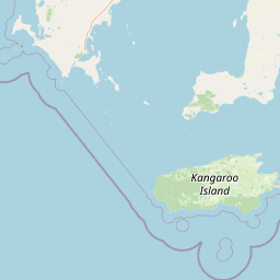
Map view of Carribie Conservation Park

Use this park location map to pinpoint Carribie Conservation Park in Australia, understand its exact geographic position, and read its mapped placement within the surrounding landscape more clearly.

Pigeon | © OpenStreetMap contributors

Location context for Carribie Conservation Park

South Australia
Park atlas

Compare surrounding regional reserves and connected southern peninsula landscapes

Other Parks and Protected Areas Near Carribie Conservation Park

Continue exploring regional conservation areas and native vegetation remnants situated across the surrounding Yorke Peninsula landscape. Comparing adjacent protected habitats provides deeper geographic context for understanding surviving botanical communities in southern Australia.
National parkAustralia
About 30 km away#1 closest

Southwest

Dhilba Guuranda-Innes National Park: A Detailed Look at Its Australian Protected Landscape

Explore the park's mapped geography and natural terrain.

This section offers a focused atlas exploration of Dhilba Guuranda-Innes National Park, detailing its significance as a protected natural area within Australia. Gain understanding of its unique geographic characteristics, mapped boundaries, and its contribution to the country's diverse natural landscapes. This provides detailed context for anyone interested in Australia's protected land inventory and regional geography.

Area
94.15 km²
Established
1970
Visitors
200K annual
Relief
Mixed relief
National parkAustralia
About 30 km away#2 closest

Southwest

Innes National Park National Park: Mapped Protected Landscape and Regional Geography

Explore its geographic setting and natural terrain.

Delve into the protected landscape and geographic particulars of Innes National Park. This entry provides detailed insights into its mapped boundaries and the surrounding natural terrain within Australia. Understanding Innes National Park's place in the broader geographic atlas helps users compare and contrast protected areas across different regions and nations.

IUCN
II
Nature reserveSouth Australia
About 66 km away#3 closest

Northeast

Goose Island Conservation Park: Marine Nature Reserve Geography and Protected Island Boundaries

Spencer Gulf offshore refuge and seabird breeding habitat

Goose Island Conservation Park consists of a scattered ring of islands and rocky outcrops in the Spencer Gulf. This nature reserve provides a secluded, wind-swept environment that serves as a vital sanctuary for breeding black-faced cormorant populations and Australian sea lions. The area is defined by its marine-weathered terrain and offshore isolation, acting as a protected link in the broader coastal geography of South Australia.

Area
0.35 km²
Established
1972
IUCN
III
Visitors
300 annual
National parkSouth Australia
About 80 km away#4 closest

West

Lincoln National Park National Park: Mapped Protected Area and Geographic Landscape Identity

South Australia's protected landscape with detailed park boundaries.

Gain a comprehensive atlas perspective on Lincoln National Park, a designated national park in South Australia. This resource details the park's mapped boundaries, offering clear geographic context and highlighting its role as a protected landscape. Understand its place within the regional geography of South Australia, providing essential data for landscape exploration and atlas-based research.

Area
216.38 km²
Established
1941
IUCN
II
Relief
Upland
National parkSouth Australia
About 87 km away#5 closest

South

Flinders Chase National Park: A Detailed National Park Entry for Map Exploration in South Australia

Explore mapped boundaries and regional geographic context.

This dedicated entry for Flinders Chase National Park provides critical geographic and protected-area data, functioning as a key point within the MoriAtlas for understanding Australia's conservation landscapes. Investigate the specific mapped boundaries of this national park, situate it within the regional geography of South Australia, and grasp its identity as a distinct protected land. The information here supports structured exploration for anyone seeking detailed atlas context on natural park entities.

Area
326.61 km²
Established
1972
IUCN
II
Relief
Upland
Nature reserveSouth Australia
About 88 km away#6 closest

Southeast

Busby Islet Conservation Park: Coastal Protected Area and Nature Reserve Mapping

Geography of a crucial seabird sanctuary in Nepean Bay

Busby Islet Conservation Park is a protected island reserve in South Australia known for its role as a breeding ground for Australian pelicans, cormorants, and various shorebird species. As a strict nature reserve, this low-lying rocky outcrop stands as a vital migratory wader roost along the north coast of Kangaroo Island, preserving essential coastal habitats through its long-standing protected status.

Area
0.17 km²
Established
1967
IUCN
Ia
Relief
Lowland
State or regional parkKangaroo Island
About 90 km away#7 closest

Southeast

Cygnet Estuary Conservation Park: Protected Estuarine Geography and Mapped Wetlands

A focused coastal reserve on the shores of Kangaroo Island

Located on the northern side of Kangaroo Island, Cygnet Estuary Conservation Park provides a protected zone for tidal lagoons and river-mouth mudflats. The park serves as a key example of habitat-focused conservation, preserving the unique transition zone where the Cygnet River meets Nepean Bay. This mapped area highlights the subdued coastal landforms and fringing estuarine vegetation characteristic of South Australia's sheltered shores.

Area
1.39 km²
Established
2014
IUCN
III
Relief
Lowland
Wildlife reserveSouth Australia
About 104 km away#8 closest

South

Cape Gantheaume Conservation Park: Coastal Landscapes and Protected Area Atlas

South Australia wildlife reserve mapping and geography

Discover the geographic layout of Cape Gantheaume Conservation Park in South Australia. This protected area on Kangaroo Island features a distinct transition between the inland Murray Lagoon wetlands, expansive dune systems at D'Estrees Bay, and the offshore environment of Pelorus Islet, offering a comprehensive view of southern coastal terrain.

Area
42.13 km²
Established
1971
IUCN
Ia
Relief
Lowland

Common questions about visiting, size, designation, and location context for Carribie Conservation Park

Carribie Conservation Park FAQs for park facts, access, geography, and protected area context

Find quick answers about Carribie Conservation Park, including protected-area facts, park geography, trail and visitor context, and how the park fits into its surrounding country and regional landscape.
MoriAtlas Explorer

Continue Your Protected Areas Search Across the Global Atlas

Deepen your exploration by continuing the structured search for national parks and protected areas worldwide. Utilize the comprehensive filtering capabilities to compare different conservation landscapes and refine your understanding of global park geography. Discover more about the distribution and characteristics of protected natural areas.

Global natural geography