

Mori Atlas logo
National parkChaloem Phrakiat Thai Prachan National Park

Discover the protected landscape identity and geographic context within Ratchaburi Province.

Chaloem Phrakiat Thai Prachan National Park: National Park with Mapped Boundaries and Regional Geography

Chaloem Phrakiat Thai Prachan National Park is a designated national park offering a unique opportunity for atlas-style exploration of its protected boundaries and surrounding geography. Situated within Ratchaburi Province, Thailand, this park provides a focal point for understanding regional land designations and mapped natural landscapes. Users can delve into its specific geographic setting, contributing to a structured overview of protected areas and their landscape context.

National ParksUNESCO World Heritage SitesMixed Deciduous ForestsHot SpringsWaterfallsWildlife Conservation

Chaloem Phrakiat Thai Prachan National Park

National park

Park overview

Structured park overview, official facts, and landscape profile for Chaloem Phrakiat Thai Prachan National Park

Chaloem Phrakiat Thai Prachan National Park park facts, protected area profile, and essential visitor context
Review the core facts for Chaloem Phrakiat Thai Prachan National Park, including designation, size, terrain, visitor scale, habitats, and operating context in one park-focused overview.

About Chaloem Phrakiat Thai Prachan National Park

Chaloem Phrakiat Thai Prachan National Park occupies a significant position within Thailand's western protected area network,位于 Ratchaburi Province approximately 100 kilometers from Bangkok. The park was formally established in January 2012 as the 103rd national park in Thailand, representing a relatively recent addition to the country's protected lands. Its establishment reflected growing recognition of the ecological importance of the Kaeng Krachan forest region, which spans the provinces of Phetchaburi, Ratchaburi, and Prachuap Khiri Khan.

The park's inclusion in the Kaeng Krachan Forest Complex UNESCO World Heritage Site in 2021 elevated its international conservation profile. This complex represents one of the largest contiguous forest areas remaining in mainland Southeast Asia, providing critical habitat for species ranging from large mammals to migratory birds. The mixed deciduous forest character of the park supports a complex ecological community adapted to seasonal variation in rainfall and temperature.

Visitor facilities at the park center on its natural hot springs and waterfall areas, which offer accessible natural attractions within the protected landscape. The park provides opportunities for nature observation, hiking, and environmental education, though infrastructure remains limited compared to more established Thai national parks.

Quick facts and research context for Chaloem Phrakiat Thai Prachan National Park

Chaloem Phrakiat Thai Prachan National Park lies in Ratchaburi Province, approximately 100 kilometers west of Bangkok. The park covers 328.05 square kilometers of protected land established in 2012 under the management of Thailand's Department of National Parks, Wildlife and Plant Conservation. It is categorized as an IUCN Category II protected area, representing national park status. The park is part of the Kaeng Krachan Forest Complex, which achieved UNESCO World Heritage Site status in 2021. The area features mixed deciduous forest ecosystems, hot springs, and waterfall formations that attract both conservation researchers and nature visitors.

Park context

Deeper park guide and search-rich context for Chaloem Phrakiat Thai Prachan National Park

Chaloem Phrakiat Thai Prachan National Park history, landscape, wildlife, and travel context
Explore Chaloem Phrakiat Thai Prachan National Park through its history, landscape character, ecosystems, wildlife, conservation priorities, cultural context, and seasonal travel timing in a structured park guide built for atlas discovery and search intent.

Why Chaloem Phrakiat Thai Prachan National Park stands out

This national park is best known for its inclusion in the UNESCO-designated Kaeng Krachan Forest Complex, representing one of Southeast Asia's most significant protected forest areas. The park's well-preserved mixed deciduous forests support notable wildlife populations, particularly large mammals such as Sambar deer and Muntjacs, as well as prominent bird species including various hornbill varieties. The presence of natural hot springs and waterfalls provides the park with recreational and scenic appeal that distinguishes it within Thailand's western forest corridor. The area serves as an ecological bridge connecting multiple protected areas within the forest complex.

Chaloem Phrakiat Thai Prachan National Park history and protected-area timeline

Chaloem Phrakiat Thai Prachan National Park was established on 25 January 2012, making it one of Thailand's younger national parks. The park was created as part of Thailand's ongoing efforts to expand protected area coverage in biologically significant forest regions. Its designation followed recognition of the Kaeng Krachan forest region's exceptional ecological value, which had already prompted the creation of adjacent protected areas including Kaeng Krachan National Park and Kui Buri National Park.

The park's name honors the royal initiative in conservation, following a Thai tradition of naming protected areas after royal figures or concepts. The area had previously existed as part of larger forest reserve designations before achieving national park status.

The 2021 UNESCO World Heritage inscription of the Kaeng Krachan Forest Complex brought international recognition to the entire region, including Chaloem Phrakiat Thai Prachan. This designation followed years of scientific assessment and conservation advocacy, highlighting the global significance of Thailand's forest preservation efforts.

Chaloem Phrakiat Thai Prachan National Park landscape and geographic character

The terrain within Chaloem Phrakiat Thai Prachan National Park consists of undulating hills and valleys characteristic of the western Thai forest landscape. The area lies within the Tenasserim Hills region, a mountain range that extends along the border between Thailand and Myanmar. Elevations within the park support mixed deciduous forest communities that transition between lowland and sub-montane vegetation zones.

The park contains several streams and watercourses that feed into the larger river systems draining toward the Gulf of Thailand. Natural hot springs emerge in specific areas where geothermal activity intersects with the local geology, creating unique microenvironments within the forest. Waterfall formations occur along the park's drainage patterns, with the most accessible features developed as visitor attractions.

The forest cover consists predominantly of mixed deciduous species that lose their leaves during the dry season, creating distinctive seasonal changes in the landscape appearance. The forest structure includes both mature canopy specimens and secondary growth areas, reflecting the park's relatively recent protected status.

Chaloem Phrakiat Thai Prachan National Park ecosystems, habitats, and plant life

The ecological character of Chaloem Phrakiat Thai Prachan National Park centers on its mixed deciduous forest ecosystem, which represents a major habitat type across mainland Southeast Asia. These forests typically feature diverse tree species that drop their leaves during the dry season between November and April, creating dynamic seasonal cycles of foliage change and wildlife activity. The well-preserved nature of the forest within park boundaries distinguishes this area, as many comparable forests in the region have experienced degradation from agricultural expansion and logging.

The forest ecosystem supports complex food webs and habitat structures that sustain both forest-dwelling and migratory species. Canopy species include various dipterocarp and leguminous trees, while the understory contains bamboo stands and dense shrub layers in more open areas. The forest provides critical watershed functions for downstream communities in Ratchaburi Province.

Chaloem Phrakiat Thai Prachan National Park wildlife and species highlights

The mammalian fauna of Chaloem Phrakiat Thai Prachan National Park includes several notable species that depend on intact forest habitats. Sambar deer represent the largest ungulate species present, maintaining populations in the park's forested areas where they browse on vegetation and access water sources. Muntjacs, also known as barking deer, are commonly encountered and contribute to the park's wildlife viewing appeal. These small deer species occupy different ecological niches within the forest, reducing competition for resources.

Birdlife within the park features hornbill species prominently, with several varieties present in the forest canopy. Hornbills serve as important seed dispersers within the forest ecosystem, contributing to tree reproduction and forest regeneration. The mixed deciduous forest environment also supports numerous resident and migratory bird species throughout the year. Reptiles, amphibians, and fish inhabit the park's water systems, with various species adapted to both permanent and seasonal water bodies. The hot spring areas support specialized species tolerant of warmer water conditions.

Chaloem Phrakiat Thai Prachan National Park conservation status and protection priorities

Chaloem Phrakiat Thai Prachan National Park contributes to regional conservation objectives through its inclusion in the Kaeng Krachan Forest Complex, which represents one of Southeast Asia's largest and most important protected forest landscapes. The UNESCO World Heritage designation in 2021 reflected the area's exceptional biodiversity values and the critical ecosystem services provided by these forests, including watershed protection, carbon storage, and wildlife habitat maintenance. The park's mixed deciduous forests represent a habitat type that has experienced significant reduction across its historical range in Thailand and mainland Southeast Asia, making protected areas like this essential for long-term species survival. Management by Thailand's Department of National Parks, Wildlife and Plant Conservation implements conservation protocols including patrolling against illegal activities and monitoring of wildlife populations. The park also functions as a biological corridor connecting the larger Kaeng Krachan and Kui Buri protected areas, enabling wildlife movement across a contiguous forest landscape.

Top sights and standout views in Chaloem Phrakiat Thai Prachan National Park

The park's standout features include its status as part of a UNESCO World Heritage Site, its well-preserved mixed deciduous forests, and accessible natural attractions including hot springs and waterfalls. The wildlife viewing opportunities, particularly for hornbills and deer species, provide primary draw for nature enthusiasts visiting the area. The relatively recent establishment as a national park means the area maintains strong ecological integrity while offering visitor experiences in a less crowded setting compared to Thailand's more developed parks.

Best time to visit Chaloem Phrakiat Thai Prachan National Park

The optimal visiting period for Chaloem Phrakiat Thai Prachan National Park spans from November through February, when dry season conditions provide comfortable temperatures and easier trail conditions. The forest landscape during this period features reduced foliage as deciduous species drop their leaves, improving wildlife sighting opportunities as animals concentrate around remaining water sources. The hot springs remain accessible year-round, though the surrounding vegetation changes substantially between wet and dry seasons. March through May bring higher temperatures that may limit midday outdoor activities, while the wet season from June through October can create challenging travel conditions on forest trails.

Park location guide

Geography guide, regional context, and park location map for Chaloem Phrakiat Thai Prachan National Park

Chaloem Phrakiat Thai Prachan National Park park geography, regions, and map view in Thailand
Understand where Chaloem Phrakiat Thai Prachan National Park sits in Thailand through a broader geographic reading of the surrounding landscape, nearby location context, and its mapped position within the national park landscape.

How Chaloem Phrakiat Thai Prachan National Park fits into Thailand

Thailand is a Southeast Asian nation formerly called Siam, located in mainland Southeast Asia. It operates as a unitary parliamentary constitutional monarchy under King Vajiralongkorn. The country borders Myanmar, Laos, Cambodia, and Malaysia, with maritime boundaries involving Vietnam, Indonesia, and India. Thailand has a population of nearly 66 million and covers approximately 513,120 km². Historically, the Sukhothai Kingdom marks the beginning of Thai history, followed by the powerful Ayutthaya Kingdom.

Wider geography shaping Chaloem Phrakiat Thai Prachan National Park in Thailand

Thailand occupies mainland Southeast Asia with borders to Myanmar (west/northwest), Laos (east/northeast), Cambodia (southeast), and Malaysia (south). The country has coastline along the Gulf of Thailand to the southeast and the Andaman Sea to the southwest. The territory covers approximately 513,120 km².

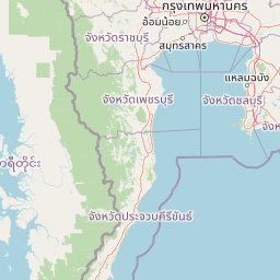
Map view of Chaloem Phrakiat Thai Prachan National Park

Use this park location map to pinpoint Chaloem Phrakiat Thai Prachan National Park in Thailand, understand its exact geographic position, and read its mapped placement within the surrounding landscape more clearly.

Pigeon | © OpenStreetMap contributors

Location context for Chaloem Phrakiat Thai Prachan National Park

Ratchaburi Province
Park atlas

Trace the geographic spread of conserved forests and mountain terrain across Thailand's western protected areas, including the Kaeng Krachan Forest Complex.

Explore Nearby National Parks and Protected Areas Around Chaloem Phrakiat Thai Prachan National Park
Expand your exploration beyond Chaloem Phrakiat Thai Prachan National Park to browse other national parks and protected areas across Thailand's western geography, including the extensive Kaeng Krachan Forest Complex. Compare diverse conservation landscapes, trace mountain park distributions, and identify connected forest reserves, deepening your atlas-style understanding of this significant ecological region.
National parkPhetchaburi Province

Kaeng Krachan National Park: Thailand National Park Atlas and Protected Landscape

Mapped boundaries and regional geography of this national park.

Access detailed geographic information for Kaeng Krachan National Park, a protected national park located in Phetchaburi Province, Thailand. Understand its specific landscape context and explore its mapped boundaries within the regional geography. This resource is designed for structured atlas-driven discovery of protected natural areas.

Area
2,915 km²
Established
1981
IUCN
II
Visitors
103.5K annual
National parkPrachuap Khiri Khan Province

Khao Sam Roi Yot National Park: A National Park within Prachuap Khiri Khan Province's Geography

Explore the mapped protected landscape and regional context.

Investigate Khao Sam Roi Yot National Park as a distinct protected area and national park entity within the geographic framework of Prachuap Khiri Khan Province. This dedicated page offers insights into its mapped boundaries, regional landscape character, and its contribution to the atlas of protected lands in western Thailand. Understand the park's environmental geography and its specific place within the broader national conservation efforts.

Area
98 km²
Established
1966
IUCN
II
Visitors
164.7K annual
Watercolor illustration of a serene landscape featuring a body of water, distant hills, and green vegetation
National parkKanchanaburi Province

Sai Yok National Park: Protected Landscape Boundaries and Regional Geographic Context

Explore the mapped terrain and park geography within Kanchanaburi.

Sai Yok National Park serves as a vital protected area within Kanchanaburi Province, offering a clear focus for geographic exploration and atlas-based understanding. This entry details the park's specific mapped boundaries and its role within the broader regional landscape context, providing essential data for comprehending its natural geography and conservation significance.

Area
500 km²
Established
1980
IUCN
II
Visitors
67.7K annual
National parkKanchanaburi Province

Khuean Srinagarindra National Park: A Protected Landscape in Kanchanaburi Province's Geography

Explore the mapped terrain and natural context of this national park.

Khuean Srinagarindra National Park stands as a distinct protected landscape within Kanchanaburi Province. This page provides a gateway to understanding its geographic identity, mapped boundaries, and natural terrain characteristics. As a national park, it offers rich opportunities for those seeking to explore the regional geography and protected areas of Thailand through a structured, atlas-focused lens.

Area
1,532 km²
Established
1981
IUCN
II
Visitors
71K annual
National parkKanchanaburi Province

Chaloem Rattanakosin National Park: National Park Status and Geographic Exploration

Mapped protected area in Kanchanaburi Province, Thailand.

Chaloem Rattanakosin National Park represents a crucial protected landscape within Kanchanaburi Province, identified as a national park. This entry offers a foundation for understanding its geographic boundaries and regional context, providing essential detail for atlas-based exploration of Thailand's natural protected areas and their mapped distribution across the landscape.

Area
59 km²
Established
1980
IUCN
II
Visitors
31.5K annual
National parkSuphan Buri Province

Phu Toei National Park: National Park Atlas and Mapped Landscape Exploration in Suphan Buri Province

Discover the protected area's geographic context and natural terrain.

Phu Toei National Park is a designated national park offering a unique perspective on protected landscapes within Suphan Buri Province, Thailand. This park serves as a crucial entity for atlas-based geographic discovery, highlighting its specific mapped boundaries and the surrounding natural terrain. Users can explore the park's inherent geographic character and its role within Thailand's network of conservation areas.

Area
317 km²
Established
1998
IUCN
II
Visitors
8.8K annual
National parkKanchanaburi Province

Lam Khlong Ngu National Park: A Protected National Park in Kanchanaburi Province

Explore mapped boundaries and regional geography.

Lam Khlong Ngu National Park offers a distinct protected landscape within Kanchanaburi Province. As a national park, it contributes to the understanding of Thailand's diverse geography and conservation areas. Users can explore its mapped features and discover its place within the broader regional context of protected lands.

Area
673 km²
Established
2009
Relief
Mountain
Climate
Tropical
National parkKanchanaburi Province

Thong Pha Phum National Park: A Protected Landscape in Kanchanaburi Province, Thailand

National park mapped geography and regional context.

Thong Pha Phum National Park is a significant national park in Thailand, situated within Kanchanaburi Province. This page details its protected area status and provides essential geographic context, enabling users to explore its mapped boundaries and understand its role within the regional landscape. Focus on discovery of its natural terrain and atlas-relevant characteristics.

Area
1,236 km²
Established
2009
IUCN
II
Visitors
123.3K annual

Common questions about visiting, size, designation, and location context for Chaloem Phrakiat Thai Prachan National Park

Chaloem Phrakiat Thai Prachan National Park FAQs for park facts, access, geography, and protected area context
Find quick answers about Chaloem Phrakiat Thai Prachan National Park, including protected-area facts, park geography, trail and visitor context, and how the park fits into its surrounding country and regional landscape.
MoriAtlas Explorer

Continue Your Protected Areas Search Across the Global Atlas

Deepen your exploration by continuing the structured search for national parks and protected areas worldwide. Utilize the comprehensive filtering capabilities to compare different conservation landscapes and refine your understanding of global park geography. Discover more about the distribution and characteristics of protected natural areas.

Global natural geography