Mori Atlas logo
National parkChaloem Rattanakosin National Park

Discover the mapped boundaries and regional geography of this national park in Kanchanaburi Province.

Chaloem Rattanakosin National Park: Thailand's Protected Landscape and Geographic Context

Chaloem Rattanakosin National Park stands as a significant protected area within the geographic landscape of Kanchanaburi Province, Thailand. This page provides an atlas-oriented perspective, detailing the park's identity as a national park and its place within the regional terrain. Explore the mapped context and understand the protected landscape that defines this key natural area.

Cave systemsWaterfallsMountain landscapesDry evergreen forestDipterocarp forestWestern Forest Complex

Chaloem Rattanakosin National Park

National park

Park overview

Structured park overview, official facts, and landscape profile for Chaloem Rattanakosin National Park

Chaloem Rattanakosin National Park park facts, protected area profile, and essential visitor context
Review the core facts for Chaloem Rattanakosin National Park, including designation, size, terrain, visitor scale, habitats, and operating context in one park-focused overview.

About Chaloem Rattanakosin National Park

Chaloem Rattanakosin National Park occupies a mountainous landscape in western Thailand's Kanchanaburi Province, positioned roughly 97 kilometres north of the provincial capital within Nong Prue District. At 59 square kilometres, it represents the smallest national park in Kanchanaburi yet contains a remarkably diverse range of habitats and geological features within its boundaries. The park's terrain is dominated by limestone mountain ridges, with Khao Kamphaeng standing as the highest peak at 1,260 metres above sea level. This rugged topography has given rise to an extensive network of caves, which constitute the park's primary attractions and hold significant archaeological and cultural value. The protected area is incorporated into Thailand's Western Forest Complex, a coordinated network of parks and wildlife sanctuaries that collectively preserve one of the country's most important forest ecosystems. The park's establishment in 1980 marked a milestone in Thailand's conservation history as the 17th national park designated under the national parks system, reflecting growing recognition of the need to protect the nation's western forest habitats and their biodiversity.

Quick facts and research context for Chaloem Rattanakosin National Park

Chaloem Rattanakosin National Park covers 59 square kilometres in Kanchanaburi Province, Thailand, established in February 1980. The park features mountainous terrain with its highest peak, Khao Kamphaeng, rising to 1,260 metres. It is the smallest national park in Kanchanaburi Province and belongs to the Western Forest Complex protected area network. The park is managed by Thailand's Department of National Parks, Wildlife and Plant Conservation and received approximately 31,500 visitors in 2019. Its cave systems contain archaeological findings including ancient human remains and weapons.

Park context

Deeper park guide and search-rich context for Chaloem Rattanakosin National Park

Chaloem Rattanakosin National Park history, landscape, wildlife, and travel context
Explore Chaloem Rattanakosin National Park through its history, landscape character, ecosystems, wildlife, conservation priorities, cultural context, and seasonal travel timing in a structured park guide built for atlas discovery and search intent.

Why Chaloem Rattanakosin National Park stands out

Chaloem Rattanakosin is best known for its elaborate cave systems, particularly the Than Lot Noi and Than Lot Yai caves, which feature dramatic stalactite and stalagmite formations. The park's multi-tiered waterfalls, including Than Thong with 15 levels and Than Ngoen with seven levels, provide additional natural attractions. Beyond its geological features, the park preserves significant archaeological evidence within its caves, where ancient skeletal remains and weapons have been discovered, offering a window into Thailand's historical conflicts during the Ayutthaya period.

Chaloem Rattanakosin National Park history and protected-area timeline

The establishment of Chaloem Rattanakosin National Park on 12 February 1980 represented Thailand's commitment to preserving its western forest landscapes, with the park becoming the 17th national park in the country. Prior to its formal protection, the area had already demonstrated significant archaeological importance, with excavations within cave systems revealing artefacts and human remains that provide insights into regional history. These findings, believed to date from the closing era of the Ayutthaya Kingdom, are thought to be associated with invading Burmese soldiers who penetrated this region during periods of conflict between the two kingdoms. The caves of Than Lot Yai, in particular, have yielded ancient skeletal remains and weapons that offer tangible evidence of historical military activity in the area. Since its designation, the park has been managed by Thailand's Department of National Parks, Wildlife and Plant Conservation, which oversees visitor access, habitat management, and conservation programmes throughout the protected area.

Chaloem Rattanakosin National Park landscape and geographic character

The landscape of Chaloem Rattanakosin National Park is defined by its mountainous terrain, characterised by steep limestone ridges and peaks that rise sharply from the surrounding lowlands. The park's highest point, Khao Kamphaeng, reaches an elevation of 1,260 metres and forms a prominent backdrop to the forest-covered valleys below. The mountainous terrain has been shaped by geological processes that have produced an extensive network of caves, particularly in the limestone formations where water erosion over millennia has created vast chambers and passages. Among these, the Than Lot Noi cave extends approximately 300 metres into the hillside, featuring impressive columns of stalactites and stalagmites that have formed over countless centuries. The park also contains several stream systems that cascade down the mountain slopes, creating the multi-tiered waterfalls that rank among its most visited attractions. The Than Thong waterfall descends through 15 distinct levels, while the smaller Than Ngoen waterfall drops over seven levels, both providing scenic focal points within the park's topography.

Chaloem Rattanakosin National Park ecosystems, habitats, and plant life

Chaloem Rattanakosin National Park preserves a complex mosaic of forest types that reflect the diversity of Thailand's western forest ecosystems. The park's vegetation includes dry evergreen forest, which dominates the valley floors and lower slopes, characterised by tree species that retain their foliage through the dry season. Mixed with these evergreen stands are areas of dipterocarp forest, where large canopy trees from the Dipterocarpaceae family dominate, as well as sections of deciduous forest that lose their leaves during the dry months. Bamboo forest also occurs within the park, forming dense stands in certain areas. The composition of these forests includes commercially valuable species such as Pterocarpus macrocarpus, Afzelia xylocarpa, Hopea odorata, and Dipterocarpus alatus, all of which contribute to the ecological diversity and structural complexity of the park's habitats.

Chaloem Rattanakosin National Park wildlife and species highlights

The forests of Chaloem Rattanakosin support a notable community of large mammals, with the park providing habitat for both tiger and leopard, representing Thailand's top predators within the Western Forest Complex. Herbivore species include banteng, a wild cattle species, and gaur, the largest living bovine, both of which inhabit the park's forested areas and grassy clearings. The arboreal mammalian community is represented by the lar gibbon, whose calls echo through the canopy as one of the park's most characteristic sounds. Bird diversity within the park includes several notable species, from the striking oriental pied hornbill with its distinctive casqued beak to smaller species such as Tickell's blue flycatcher and the coppersmith barbet. Ground-dwelling birds including francolins also inhabit the forest floor. A particularly unusual resident is the barking tree frog, a rare amphibian whose vocalisation strikingly resembles the sound of a dog barking, an adaptation that serves as a defensive behaviour or territorial advertisement within the park's cave and forest environments.

Chaloem Rattanakosin National Park conservation status and protection priorities

Chaloem Rattanakosin National Park forms a critical component of the Western Forest Complex, Thailand's largest network of protected areas encompassing over 15,000 square kilometres of contiguous forest habitat across the country's western mountain ranges. This complex integrates multiple national parks, wildlife sanctuaries, and forest reserves under coordinated management aimed at preserving ecological connectivity and allowing wildlife populations to maintain viable numbers across a landscape-scale protected area. The park's inclusion in this network recognises its importance in preserving not only scenic geological features and cave ecosystems but also the forest habitats that support populations of threatened species including Indochinese tigers and leopards. The protection of forest cover within the park also contributes to watershed conservation, regulating water flow in streams that feed the waterfalls and maintaining ecological function in the broader catchment area.

Chaloem Rattanakosin National Park cultural meaning and human context

The caves of Chaloem Rattanakosin hold historical significance beyond their geological formations, serving as repositories of archaeological material that illuminate regional history during the turbulent final years of the Ayutthaya Kingdom. The discovery of human remains and weapons within these caves, particularly at the Than Lot Yai site, provides physical evidence of the conflicts that periodically engulfed western Thailand as Burmese forces advanced into the kingdom's territories. These findings transform the caves from purely natural wonders into cultural heritage sites where the natural and historical landscapes intersect. The park's name, Chaloem Rattanakosin, honours the Chakri dynasty and the Rattanakosin period of Thai history, linking the protected area to the broader narrative of Thai state formation and consolidation.

Top sights and standout views in Chaloem Rattanakosin National Park

The cave systems of Chaloem Rattanakosin stand as the park's most distinctive feature, with Than Lot Noi offering a 300-metre passage through impressive stalactite and stalagmite formations, while Than Lot Yai provides both geological beauty and archaeological significance through its ancient remains and weapons. The park's waterfalls, particularly the 15-tiered Than Thong and seven-tiered Than Ngoen, provide accessible natural attractions that complement the underground wonders. The mountainous backdrop, topped by the 1,260-metre Khao Kamphaeng peak, creates a scenic setting for the forest trails and viewpoints that allow visitors to appreciate the park's varied terrain. Wildlife viewing opportunities, particularly for those seeking to observe lar gibbons, hornbills, and the unusual barking tree frog, add ecological dimension to the visitor experience.

Best time to visit Chaloem Rattanakosin National Park

The optimal period for visiting Chaloem Rattanakosin National Park coincides with the cooler, drier months from November through February, when temperatures are more comfortable for hiking and the reduced rainfall makes cave exploration safer and more accessible. The transition months of March to May bring warmer conditions as Thailand enters its hot season, which can make outdoor activities more challenging, though the park's forest cover provides some relief from the heat. The rainy season from June through October brings increased precipitation that can affect trail conditions and create safety concerns within cave systems, though the waterfalls typically display their strongest flows during and immediately after the monsoon period. Visitors interested in wildlife observation may find the dry season particularly productive as animals concentrate around remaining water sources, though the park's diverse habitats support year-round biodiversity.

Park location guide

Geography guide, regional context, and park location map for Chaloem Rattanakosin National Park

Chaloem Rattanakosin National Park park geography, regions, and map view in Thailand
Understand where Chaloem Rattanakosin National Park sits in Thailand through a broader geographic reading of the surrounding landscape, nearby location context, and its mapped position within the national park landscape.

How Chaloem Rattanakosin National Park fits into Thailand

Thailand is a Southeast Asian nation formerly called Siam, located in mainland Southeast Asia. It operates as a unitary parliamentary constitutional monarchy under King Vajiralongkorn. The country borders Myanmar, Laos, Cambodia, and Malaysia, with maritime boundaries involving Vietnam, Indonesia, and India. Thailand has a population of nearly 66 million and covers approximately 513,120 km². Historically, the Sukhothai Kingdom marks the beginning of Thai history, followed by the powerful Ayutthaya Kingdom.

Wider geography shaping Chaloem Rattanakosin National Park in Thailand

Thailand occupies mainland Southeast Asia with borders to Myanmar (west/northwest), Laos (east/northeast), Cambodia (southeast), and Malaysia (south). The country has coastline along the Gulf of Thailand to the southeast and the Andaman Sea to the southwest. The territory covers approximately 513,120 km².

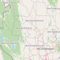
Map view of Chaloem Rattanakosin National Park

Use this park location map to pinpoint Chaloem Rattanakosin National Park in Thailand, understand its exact geographic position, and read its mapped placement within the surrounding landscape more clearly.

Pigeon | © OpenStreetMap contributors

Location context for Chaloem Rattanakosin National Park

Kanchanaburi Province
Park atlas

Map the surrounding protected landscapes of western Thailand for deeper geographic exploration and comparison.

Explore National Parks and Protected Areas Near Chaloem Rattanakosin National Park
Discover other national parks and protected areas in the regional geography surrounding Chaloem Rattanakosin National Park, including sites within Thailand's broader Western Forest Complex. Compare diverse protected landscapes, tracing the geographic spread of conservation areas known for limestone karst, extensive cave systems, and cascading waterfalls.
National parkKanchanaburi Province

Khuean Srinagarindra National Park: A Protected Landscape in Kanchanaburi Province's Geography

Explore the mapped terrain and natural context of this national park.

Khuean Srinagarindra National Park stands as a distinct protected landscape within Kanchanaburi Province. This page provides a gateway to understanding its geographic identity, mapped boundaries, and natural terrain characteristics. As a national park, it offers rich opportunities for those seeking to explore the regional geography and protected areas of Thailand through a structured, atlas-focused lens.

Area
1,532 km²
Established
1981
IUCN
II
Visitors
71K annual
National parkSuphan Buri Province

Phu Toei National Park: National Park Atlas and Mapped Landscape Exploration in Suphan Buri Province

Discover the protected area's geographic context and natural terrain.

Phu Toei National Park is a designated national park offering a unique perspective on protected landscapes within Suphan Buri Province, Thailand. This park serves as a crucial entity for atlas-based geographic discovery, highlighting its specific mapped boundaries and the surrounding natural terrain. Users can explore the park's inherent geographic character and its role within Thailand's network of conservation areas.

Area
317 km²
Established
1998
IUCN
II
Visitors
8.8K annual
National parkKanchanaburi Province

Lam Khlong Ngu National Park: A Protected National Park in Kanchanaburi Province

Explore mapped boundaries and regional geography.

Lam Khlong Ngu National Park offers a distinct protected landscape within Kanchanaburi Province. As a national park, it contributes to the understanding of Thailand's diverse geography and conservation areas. Users can explore its mapped features and discover its place within the broader regional context of protected lands.

Area
673 km²
Established
2009
Relief
Mountain
Climate
Tropical
Watercolor illustration of a serene landscape featuring a body of water, distant hills, and green vegetation
National parkKanchanaburi Province

Sai Yok National Park: Protected Landscape Boundaries and Regional Geographic Context

Explore the mapped terrain and park geography within Kanchanaburi.

Sai Yok National Park serves as a vital protected area within Kanchanaburi Province, offering a clear focus for geographic exploration and atlas-based understanding. This entry details the park's specific mapped boundaries and its role within the broader regional landscape context, providing essential data for comprehending its natural geography and conservation significance.

Area
500 km²
Established
1980
IUCN
II
Visitors
67.7K annual
National parkKanchanaburi Province

Khao Laem National Park: Kanchanaburi Province Protected Landscape Atlas

Discover mapped terrain and regional geographic context.

Investigate Khao Laem National Park as a distinct protected landscape situated in Thailand's Kanchanaburi Province. This entry provides detailed geographic insights, focusing on mapped boundaries and the park's position within the region's natural atlas. It's designed for users seeking specific protected-area data and landscape context rather than general visitor information.

Area
1,497 km²
Established
1991
IUCN
II
Visitors
48.6K annual
National parkKanchanaburi Province

Thong Pha Phum National Park: A Protected Landscape in Kanchanaburi Province, Thailand

National park mapped geography and regional context.

Thong Pha Phum National Park is a significant national park in Thailand, situated within Kanchanaburi Province. This page details its protected area status and provides essential geographic context, enabling users to explore its mapped boundaries and understand its role within the regional landscape. Focus on discovery of its natural terrain and atlas-relevant characteristics.

Area
1,236 km²
Established
2009
IUCN
II
Visitors
123.3K annual
National parkNakhon Sawan Province

Mae Wong National Park: National Park Protected Area and Geographic Setting

Mapped boundaries and regional landscape of Mae Wong.

Investigate Mae Wong National Park, a designated national park offering insights into its protected landscape identity. This entry provides structured geographic data, focusing on the park's mapped boundaries and its position within the broader regional context of Nakhon Sawan Province. Examine its role as a significant protected area for atlas-based discovery and geographic understanding.

Area
894 km²
Established
1987
IUCN
II
Visitors
51.8K annual
National parkKamphaeng Phet Province

Khlong Lan National Park: National Park Protected Landscape and Geography

Explore mapped boundaries and regional context in Kamphaeng Phet Province.

Delve into the specifics of Khlong Lan National Park, a protected area designated as a national park in Thailand's Kamphaeng Phet Province. This page offers a structured view of its geographic scope, emphasizing mapped park boundaries and the surrounding natural terrain. Understand its role as a significant protected landscape within the regional geography.

Area
300 km²
Established
1985
IUCN
II
Visitors
206.4K annual

Common questions about visiting, size, designation, and location context for Chaloem Rattanakosin National Park

Chaloem Rattanakosin National Park FAQs for park facts, access, geography, and protected area context
Find quick answers about Chaloem Rattanakosin National Park, including protected-area facts, park geography, trail and visitor context, and how the park fits into its surrounding country and regional landscape.
MoriAtlas Explorer

Continue Your Protected Areas Search Across the Global Atlas

Deepen your exploration by continuing the structured search for national parks and protected areas worldwide. Utilize the comprehensive filtering capabilities to compare different conservation landscapes and refine your understanding of global park geography. Discover more about the distribution and characteristics of protected natural areas.

Global natural geography