Mori Atlas logo
Nature reserveChereninup Creek Reserve

Discover the mapped landscape and regional significance of this vital Gondwana Link protected corridor.

Chereninup Creek Reserve: A Detailed Geographic Overview of a Western Australian Nature Reserve

Chereninup Creek Reserve is a protected nature reserve located in the Great Southern region of Western Australia. The property acts as a critical habitat bridge, linking larger blocks of native vegetation between major nearby national parks. Users can examine the reserve's unique mosaic of eucalypt woodlands, Kwongan heath, and dense shrubland communities that are essential to the restoration of this biodiversity hotspot.

nature reservebush heritage australiagondwana linkgreat southern western australiakwongan heatheucalypt woodland

Chereninup Creek Reserve

Nature reserve

Park overview

Structured park overview, official facts, and landscape profile for Chereninup Creek Reserve

Chereninup Creek Reserve park facts, protected area profile, and essential visitor context

Review the core facts for Chereninup Creek Reserve, including designation, size, terrain, visitor scale, habitats, and operating context in one park-focused overview.

About Chereninup Creek Reserve

Chereninup Creek Reserve is a compact but ecologically rich conservation property in the Great Southern region of south-west Western Australia. Although small in area, it occupies a strategic position in the landscape, sitting between the Stirling Range to the west and the Fitzgerald River National Park to the east, on the southern fringe of the agricultural Wheatbelt. This placement gives it a critical role as a stepping stone of native vegetation between two much larger protected areas.

The reserve lies within one of the world's recognised biodiversity hotspots, the south-west Australian floristic region, which is renowned for its high concentration of endemic plant species. The vegetation pattern reflects this richness, with eucalypt woodlands, low Kwongan heath, and shrubland communities blending across undulating country, all drained by the seasonal flow of Chereninup Creek.

The reserve's significance is amplified by its history of land use. Roughly 60 hectares of the property had been cleared for farming before it was purchased by Bush Heritage Australia in 2003. Subsequent revegetation efforts have worked to restore native plant cover, gradually knitting the cleared sections back into the surrounding matrix of bush. This restoration work, combined with the reserve's location within the Gondwana Link project, places Chereninup Creek at the heart of one of Australia's most ambitious private conservation efforts.

Quick facts and research context for Chereninup Creek Reserve

Chereninup Creek Reserve is a privately owned nature reserve of about 8.77 square kilometres in south-west Western Australia, managed by Bush Heritage Australia. It lies between Stirling Range National Park and Fitzgerald River National Park, on the southern edge of the Wheatbelt, and forms part of the Gondwana Link habitat corridor connecting large blocks of native vegetation across the Great Southern region.

Protection and recognition

Examine the terrestrial protection scope and documented designation records

Chereninup Creek Reserve Protection Status and Conservation Recognition

Chereninup Creek Reserve maintains a documented terrestrial protection scope within the regional conservation network. Review available designation facts and management parameters for this protected area.

Protection details

Protection scope
Terrestrial
Transboundary protection
No
Park context

Deeper park guide and search-rich context for Chereninup Creek Reserve

Chereninup Creek Reserve history, landscape, wildlife, and travel context

Explore Chereninup Creek Reserve through its history, landscape character, ecosystems, wildlife, conservation priorities, cultural context, and seasonal travel timing in a structured park guide built for atlas discovery and search intent.

Why Chereninup Creek Reserve stands out

The reserve is best known for its mosaic of eucalypt woodland, dense shrubland, and Kwongan heath communities, set within a broader Gondwana Link restoration landscape between two major national parks. It is also notable as an early Bush Heritage Australia acquisition, where extensive revegetation of previously cleared farmland has expanded continuous habitat.

Chereninup Creek Reserve history and protected-area timeline

Chereninup Creek Reserve was acquired by Bush Heritage Australia in 2003, following a period during which parts of the property had been cleared for agricultural use. The purchase brought the land into the Gondwana Link project, a long-term initiative aiming to reconnect fragmented native habitat across hundreds of kilometres of south-west Western Australia.

Following the acquisition, a substantial restoration effort was undertaken. Approximately 60 hectares of previously cleared land were progressively revegetated with native plant species, extending the area of intact habitat and improving connectivity with surrounding bushland. This phased rehabilitation has defined the reserve's recent history, shifting it from a partly cleared agricultural holding into a functioning component of a continental-scale conservation corridor.

Chereninup Creek Reserve landscape and geographic character

The landscape of Chereninup Creek Reserve is shaped by gently undulating terrain, typical of the transitional country between the Wheatbelt and the southern coast of Western Australia. Rather than dramatic peaks or coastlines, the reserve's character lies in its subtle topography and the textured mosaic of vegetation that covers it.

A defining feature is Chereninup Creek itself, a seasonal watercourse that threads through the property and supplies the moisture needed to sustain dense shrub and heath communities. The surrounding slopes carry open eucalypt woodland, while lower-lying and sandier sections support Kwongan heath, a low, species-rich shrubland unique to Western Australia. The interplay of woodland, heath, and shrubland creates the visually diverse patchwork that defines the reserve.

Chereninup Creek Reserve ecosystems, habitats, and plant life

Chereninup Creek Reserve sits within the South West Australian floristic region, a globally recognised biodiversity hotspot with an unusually high number of endemic plant species. The reserve's vegetation reflects the region's characteristic layering, from emergent eucalypts over a rich understorey of dryandras, banksias, and a wide array of smaller shrubs typical of Kwongan heath.

The diversity within the reserve is notable even by south-west Australian standards, with a particularly high concentration of Eucalyptus, Dryandra, and Banksia species. These plant groups play a crucial ecological role, providing nectar resources, structural habitat complexity, and food for a wide range of insects, birds, and small mammals.

Chereninup Creek Reserve wildlife and species highlights

The wildlife of Chereninup Creek Reserve is shaped by the broader patterns of the south-west Australian bush, where the integrity of habitat mosaics determines the richness of fauna. The combination of mature woodland, dense shrubland, and restored heath provides shelter and forage for nectar-feeding birds, small marsupials, reptiles, and a rich invertebrate community supported by the reserve's flowering plants. As part of the Gondwana Link corridor, the reserve offers enhanced opportunities for species movement and persistence across a heavily cleared agricultural landscape.

Chereninup Creek Reserve conservation status and protection priorities

Chereninup Creek Reserve holds significant conservation value, both as a refuge for the flora of the south-west Australian biodiversity hotspot and as a functional piece of the Gondwana Link habitat corridor. The reserve protects a high-diversity mosaic of eucalypt woodland, shrubland, and Kwongan heath, vegetation types that have been extensively reduced elsewhere in the region through land clearing for agriculture.

By reconnecting habitat between Stirling Range National Park and Fitzgerald River National Park, the reserve contributes to landscape-scale resilience, allowing wildlife to move, forage, and recolonise across a vast area. The revegetation of approximately 60 hectares of previously cleared land further strengthens this role, actively rebuilding habitat that had been lost and reinforcing the reserve's contribution to private conservation in one of Australia's most globally significant ecoregions.

Top sights and standout views in Chereninup Creek Reserve

Chereninup Creek Reserve stands out as a key private conservation property within the Gondwana Link corridor, linking two major national parks in the Great Southern region of Western Australia. Its mosaic of eucalypt woodland, shrubland, and Kwongan heath shelters an unusually rich suite of Eucalyptus, Dryandra, and Banksia species. The reserve also illustrates the practical impact of private land acquisition and revegetation, with around 60 hectares of former farmland restored to native bush since 2003.

Best time to visit Chereninup Creek Reserve

Chereninup Creek Reserve lies in a Mediterranean-type climate region, where winters are mild and wet and summers are warm and dry. Spring is widely regarded as the most rewarding season to experience south-west Australian bushland, when wildflowers, including many of the Dryandra and Banksia species for which the reserve is noted, are in bloom and conditions are cool enough for extended walks through the bush. Autumn and winter offer greener landscapes and active wildlife, while summer, though warmer, can still provide good bird and wildlife viewing across dawn and dusk hours.
Monthly climate preview

Long-term representative monthly averages for temperature and precipitation rhythm

Chereninup Creek Reserve Climate Normals and Measured Annual Temperature Patterns

Chereninup Creek Reserve records measured long-term monthly averages tracking temperature shifts from winter lows to high summer maximums alongside baseline precipitation. Examining the complete twelve-month climate profile reveals precise baseline patterns across the representative coordinate.
Annual mean15 °C
10 °C21 °C
Jan21°
Feb21°
Mar19°
Apr17°
May13°
Jun11°
Jul10°
Aug10°
Sep12°
Oct14°
Nov17°
Dec19°
Warmest month
January

21 °C

Coolest month
July

9.8 °C

Wettest month
August

1.9 mm/day

Driest month
January

0.8 mm/day

Park location guide

Geography guide, regional context, and park location map for Chereninup Creek Reserve

Chereninup Creek Reserve park geography, regions, and map view in Australia

Understand where Chereninup Creek Reserve sits in Australia through a broader geographic reading of the surrounding landscape, nearby location context, and its mapped position within the national park landscape.

How Chereninup Creek Reserve fits into Australia

Australia is a constitutional monarchy and federal parliamentary democracy comprising six states and ten territories. With a population of nearly 28 million, it is one of the world's most urbanised countries, with most people concentrated on the eastern seaboard. The country has a high Human Development Index and is known for its cultural diversity, ancient Aboriginal heritage, and unique wildlife.

Wider geography shaping Chereninup Creek Reserve in Australia

Australia occupies the entire Australian continent, the island of Tasmania, and numerous smaller islands. It is the world's flattest and driest inhabited continent, featuring vast deserts in the interior (the Outback), tropical rainforests along the eastern coast, and a coastline bordering the Indian and Pacific Oceans.

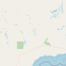
Map view of Chereninup Creek Reserve

Use this park location map to pinpoint Chereninup Creek Reserve in Australia, understand its exact geographic position, and read its mapped placement within the surrounding landscape more clearly.

Pigeon | © OpenStreetMap contributors

Location context for Chereninup Creek Reserve

Western Australia
Recorded earthquake history

Explore Historical Earthquake Records for Chereninup Creek Reserve

Consult the dedicated catalogue of seismic events recorded near Chereninup Creek Reserve. MoriAtlas provides a structured view of historical earthquake data to help you understand regional seismic patterns and activity trends in this part of Western Australia.

Chereninup Creek Reserve Earthquake History

Catalogued events

1 event

Strongest magnitude

Magnitude 3.9

Most recent event

May 15, 1977

This history includes earthquakes recorded inside the park or within 50 km of its borders

Park atlas

Compare surrounding regional reserves and neighboring conservation areas across Western Australia

Parks Near Chereninup Creek Reserve and Connected Protected Landscapes

Browsing other protected areas near Chereninup Creek Reserve reveals the broader network of transitional woodlands and connected habitat corridors across the region. Extending the geographic comparison helps trace neighboring national parks and regional reserves within the biodiversity hotspot.
Nature reserveWestern Australia
8 km away#1 closest

Northeast

Beringa Reserve Nature Reserve: Western Australia Protected Woodland Geography

Restoration landscapes and riparian corridors near Peniup Creek

Beringa Reserve serves as a significant private nature reserve in Western Australia, focusing on the restoration of eucalyptus woodland and mallee heath. This landscape acts as a functional buffer within the Gondwana Link, protecting riparian vegetation along Peniup Creek and fostering the recovery of native mammal habitats through intensive revegetation efforts.

Area
25.06 km²
Established
2007
Relief
Lowland
Climate
Mediterranean
Watercolor illustration showing mountains in the background, green vegetation, and pink meadows
National parkWestern Australia
32 km away#2 closest

East

Fitzgerald River National Park: A Western Australian Protected Landscape of Global Botanical Importance

Discover its mapped terrain, endemic flora, and UNESCO Biosphere Reserve status.

Fitzgerald River National Park stands as a protected landscape of immense ecological value in Western Australia. This national park is celebrated for its extraordinary botanical diversity, featuring more endemic plant species than any other conservation reserve in Australia. Its varied terrain, from rugged mountain ranges to coastal cliffs, provides a rich tapestry of natural habitats. As a designated UNESCO Biosphere Reserve, it offers a unique opportunity to explore mapped geographic features and understand the critical role of protected areas in conserving rare flora and distinct Mediterranean ecosystems.

Area
2,972.11 km²
Established
1973
IUCN
II
Visitors
40K annual
Nature reserveWestern Australia
About 36 km away#3 closest

Southwest

Yarrabee Wesfarmers Reserve: Mapping Woodland Conservation and Regional Geography

A vital protected nature reserve in Western Australia

Yarrabee Wesfarmers Reserve forms a significant link in the regional landscape of Western Australia, protecting marri and jarrah woodland adjacent to the Stirling Range. Through ongoing restoration, the area maintains a mosaic of mallee and Banksia habitats, supporting regional species and contributing to broader environmental connectivity.

Area
9.23 km²
Established
2006
Relief
Upland
Climate
Mediterranean
Watercolor illustration showing a landscape with mountains, a winding river, and grassy fields.
National parkWestern Australia
36 km away#4 closest

West

Stirling Range National Park: National Park Protected Area and Geographic Mapping

Discover its mapped boundaries and regional landscape context.

Stirling Range National Park is a protected national park in Western Australia, offering critical insights into regional geography and landscape mapping. This page provides structured information on the park's protected area status, its geographic setting, and its value for atlas-based exploration. Understand the extent of its mapped boundaries and discover its unique natural terrain within the broader context of Western Australia's vast geography.

Area
1,159.2 km²
Established
1913
IUCN
II
Relief
Mountain
National parkWestern Australia
52 km away#5 closest

Southwest

Hassell National Park National Park: Mapped Protected Landscape in Western Australia

Explore the geographic identity and park boundaries of Hassell National Park.

Hassell National Park offers a focused view of protected natural landscapes within Western Australia. This atlas entry details the park's specific geographic scope and its designation as a national park, providing essential context for understanding its mapped features and regional landscape. Explore how Hassell National Park contributes to the protected area geography of the state.

Area
12.65 km²
Established
1971
IUCN
II
Scope
Mixed
National parkWestern Australia
82 km away#6 closest

South

Waychinicup National Park: National Park Protected Landscape Atlas Entry

Explore Western Australia's mapped natural landscapes and park geography.

Gain a structured understanding of Waychinicup National Park as a key protected landscape within Western Australia. This detailed atlas entry focuses on its geographic distribution and mapped boundaries, providing essential context for regional park and natural landscape exploration. Discover the unique characteristics of this national park's setting and its place within the broader mapped terrain.

Area
39.82 km²
Established
1990
IUCN
II
Relief
Mixed relief
Marine protected areaWestern Australia
84 km away#7 closest

Southeast

Bremer Marine Park: An Offshore Atlas of Western Australia's Protected Marine Geography

Submarine canyon mapping and regional marine environment

Bremer Marine Park protects a vast, complex submarine landscape off the south coast of Western Australia. Dominated by the deep Bremer Canyon system, this protected area serves as a primary hub for studying deep sea geomorphology, coral gardens, and the nutrient-rich upwelling processes that define this unique section of the Southern Ocean.

Area
4,472 km²
Established
2013
IUCN
II
Relief
Mixed relief
National parkWestern Australia
94 km away#8 closest

Southwest

Porongurup National Park: Ancient Granite Peaks and Karri Forest Protected Landscape

Mapped terrain and geologic history in Western Australia.

Delve into Porongurup National Park, a protected landscape in Western Australia characterized by its ancient, billion-year-old granite peaks and a rare outlier of towering karri forest. This national park offers a unique geographic perspective, showcasing dramatic mountain terrain that has stood for eons. Explore the mapped boundaries and the distinct ecosystems that thrive within this ancient mountain system, providing rich context for regional atlas discovery and understanding the park's geological significance.

Area
26.21 km²
Established
1971
IUCN
II
Relief
Mountain

Common questions about visiting, size, designation, and location context for Chereninup Creek Reserve

Chereninup Creek Reserve FAQs for park facts, access, geography, and protected area context

Find quick answers about Chereninup Creek Reserve, including protected-area facts, park geography, trail and visitor context, and how the park fits into its surrounding country and regional landscape.
MoriAtlas Explorer

Continue Your Protected Areas Search Across the Global Atlas

Deepen your exploration by continuing the structured search for national parks and protected areas worldwide. Utilize the comprehensive filtering capabilities to compare different conservation landscapes and refine your understanding of global park geography. Discover more about the distribution and characteristics of protected natural areas.

Global natural geography