Why Chimanimani National Park stands out
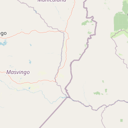
Chimanimani National Park is best known for its dramatic quartzite mountain landscape and exceptional plant endemism. The mountains support approximately 70 plant species found nowhere else on Earth, making the area a significant center of biodiversity in southern Africa. The park encompasses diverse Afromontane vegetation communities including grassland, ericaceous heathland, protea shrubland, miombo woodland, and isolated patches of montane forest. The transfrontier designation connecting the Zimbabwean park with Mozambique's Chimanimani National Reserve creates one of the larger conservation landscapes in the region, protecting a mountainous corridor that serves as an important ecological bridge across international boundaries.
Chimanimani National Park history and protected-area timeline
The Chimanimani Mountains have been home to the Ndau people for centuries, with the area's human history shaped by the complex interactions between indigenous communities and colonial powers. In the early 19th century, Nguni-speaking peoples moved into the region from what is now South Africa, with the Nguni leader Soshangane establishing the Gaza Empire, which extended from the Limpopo to the Zambezi rivers and subjugated the local Ndau populations. The late 19th century saw increasing conflict between the Gaza Empire and European colonial powers expanding from both British South Africa and Portuguese Mozambique. The Anglo-Portuguese Treaty of 1891 fixed the boundary between British and Portuguese colonial territories, dividing the Chimanimani Mountains between Southern Rhodesia and Portuguese Mozambique. A boundary dispute arose over differing interpretations of the treaty, and the final boundary between the Zambezi and Save rivers was arbitrated by Paolo Onorato Vigliani, an assistant to the King of Italy, with the arbitration completed on January 30, 1897. This boundary established the international divide that persists today and split the Ndau communities across two colonial territories. Chimanimani National Park was established by the Southern Rhodesian government in 1949 with an original area of 82 square kilometers, later expanded to 155 square kilometers. The Mozambican side of the mountains saw the creation of forest reserves in 1953, followed by the establishment of Chimanimani National Reserve in 2003 covering 640.6 square kilometers. The region experienced significant upheaval during the Rhodesian Bush War and subsequent Zimbabwe independence, with mountain passes in the area used by guerrilla fighters and areas remaining contaminated with land mines to this day.
Chimanimani National Park landscape and geographic character
The Chimanimani Mountains present a dramatic landscape of steep quartzite ridges running generally north and south, with the highest elevations reaching 2,436 meters at Monte Binga. The range includes several notable peaks including Mt. Peza (2,152m), Mt. Dombe (2,188m), and the Turret Towers (2,362m) on the Zimbabwean side, while Mt. Nhamadimo (2,144m) marks one of the higher peaks in Mozambique. The mountains rise abruptly from the low Mozambican plain, creating a striking contrast between the elevated plateau and the surrounding lowland terrain. The landscape is deeply incised by river valleys, with the mountains drained by tributaries of the Buzi River including the Rusitu (known as the Lucite in Mozambique) and the Mussapa. The terrain is characterized by rocky outcrops, cliff faces, and boulder-strewn slopes, with vegetation that changes dramatically from montane grasslands at higher elevations to miombo woodland at lower elevations. The eastward-facing slopes intercept moisture-laden winds from the Indian Ocean, creating distinctively different conditions compared to the western rain shadow slopes.
Chimanimani National Park ecosystems, habitats, and plant life
The Chimanimani Mountains support a remarkable diversity of Afromontane vegetation communities that change with elevation and substrate. Above 1,000 meters, the mountains feature grassland as the most widespread vegetation, including quartzite grasslands on the rocky substrates, schist grasslands on deeper red soils, and wet hydromorphic grasslands in lower-lying areas. Ericaceous heathland dominates quartzite-derived soils above 1,200 meters, characterized by shrubs in the heath family including several Erica species. Proteaceous shrubland occurs on schist-derived soils between 1,100 and 1,800 meters, featuring various protea species. The mountains contain three types of miombo woodland, with trees typically 4 to 8 meters tall and 20 to 60% canopy cover, including Mzhenje (Uapaca kirkiana), Msasa (Brachystegia spiciformis), and Brachystegia tamarindoides communities. Montane forests occur in scattered patches, typically in sheltered areas with year-round moisture, with the largest known patch reaching 240 hectares. These forests feature a closed canopy 10 to 15 meters high, with common trees including Neocussonia umbellifera, Ilex mitis, Podocarpus milanjianus, and Syzygium cordatum. The area is notable for its exceptional plant endemism, with approximately 70 montane plant species found nowhere else in the world.
Chimanimani National Park wildlife and species highlights
While the source material focuses primarily on plant communities rather than wildlife, the Chimanimani Mountains support diverse animal populations within their varied habitats. The montane forests provide refuge for forest-dwelling species, while the grasslands and woodlands support their own communities of birds, small mammals, and invertebrates. The transfrontier conservation area designation acknowledges the importance of the broader landscape for maintaining ecological connectivity across the international boundary. The varied elevations and vegetation types create diverse microhabitats that support different wildlife communities, from species adapted to the high-elevation heathlands to those found in the lower-elevation miombo woodlands. The forest patches, particularly those along streams and in sheltered gullies, provide important habitat for species requiring year-round moisture and cover.
Chimanimani National Park conservation status and protection priorities
Chimanimani National Park represents a significant conservation area within southern Africa, protecting one of the region's distinctive montane ecosystems. The park's establishment in 1949 and subsequent expansion reflected recognition of the area's ecological importance, while the 2003 creation of Mozambique's Chimanimani National Reserve completed the transfrontier protection framework. Together, these protected areas along with surrounding buffer zones constitute the Chimanimani Transfrontier Conservation Area, one of the larger cross-border conservation initiatives in the region. The mountains' exceptional plant endemism, with approximately 70 species found only in this area, places the Chimanimani Mountains among the most important centers of plant diversity in southern Africa. The protection of the Afromontane vegetation communities including grasslands, heathlands, woodlands, and forests helps preserve ecological processes and species that are adapted to the specific conditions of this high-elevation environment.
Chimanimani National Park cultural meaning and human context
The Chimanimani Mountains have been home to the Ndau people for centuries, with indigenous communities maintaining connections to the landscape long before colonial boundaries were imposed. The 1897 arbitration that established the international boundary split the Ndau communities between what became Zimbabwe and Mozambique, dividing traditional lands and social networks. The mountains also hold significance in more recent history as a region that experienced considerable upheaval during the Rhodesian Bush War and subsequent independence struggle, with some areas remaining inaccessible due to residual land mines.
Top sights and standout views in Chimanimani National Park
Chimanimani National Park offers visitors access to one of Zimbabwe's most scenic mountain landscapes, with dramatic quartzite peaks, diverse vegetation communities, and the opportunity to explore a transfrontier conservation area spanning two countries. The mountains' exceptional plant endemism, with approximately 70 species found nowhere else, makes the area particularly significant for botanical interest. Visitors can experience the range of Afromontane habitats from grasslands and heathlands to forests and woodlands, each supporting distinctive plant communities. The park provides opportunities for hiking and exploration of the mountain landscapes that form part of the Eastern Highlands, one of Zimbabwe's most distinctive terrain features.
Best time to visit Chimanimani National Park
The Chimanimani Mountains are best visited during the dry season from April to October, when conditions are more stable and the risk of rainfall is reduced. The summer rainy season extends from November through late March or April, and while the mountains can receive rain at any elevation above 1,500 meters throughout the year, the wet season can make trails more difficult and visibility less reliable. The dry winter months typically offer clearer skies and more predictable conditions for exploring the park, though temperatures at higher elevations can be cool, particularly during winter nights when frosts occur above 1,500 meters.