

Mori Atlas logo
Nature reserveCoocumbac Island Nature Reserve

A vital protected landscape fragment in the Manning River of New South Wales

Coocumbac Island Nature Reserve: Mapping Subtropical Rainforest and River Island Geography

Coocumbac Island Nature Reserve preserves a significant remnant of subtropical lowland rainforest, an ecosystem defined by its rare association of giant stinger trees and mature Moreton Bay figs. Situated within the tidal Manning River of New South Wales, the reserve functions as a critical protected island habitat for flying fox colonies and diverse rainforest birds. This atlas entry provides geographic context for the island's unique alluvial soil profile and its historical role as a traditional Aboriginal meeting place along the coast.

subtropical rainforestlowland rainforestriver islandManning Rivermangrovestrangler figs
A flat, vector-style illustration of a canyon or valley with two prominent waterfalls flowing down sheer cliffs into a central river, surrounded by pine trees under a pale sky.

Coocumbac Island Nature Reserve

Nature reserve

Park overview

Structured park overview, official facts, and landscape profile for Coocumbac Island Nature Reserve

Coocumbac Island Nature Reserve park facts, protected area profile, and essential visitor context

Review the core facts for Coocumbac Island Nature Reserve, including designation, size, terrain, visitor scale, habitats, and operating context in one park-focused overview.

About Coocumbac Island Nature Reserve

Coocumbac Island Nature Reserve is a compact but ecologically meaningful protected area on a small island in the Manning River, in the mid-north coast region of New South Wales, Australia. Although it covers only around 6 hectares, the reserve preserves a piece of subtropical lowland rainforest that is increasingly rare in the region, where most similar ecosystems have been cleared for agriculture and urban development.

The island lies within the tidal reach of the Manning River and is fringed by mangroves that give way, with a short transition zone, to dense lowland rainforest. The soils beneath the forest are alluvial, enriched by basaltic material carried downstream from the Barrington Tops and the Comboyne and Bulga plateaux, which supports the rich plant communities on the island. Rainfall in the nearby Taree area averages about 1,176 millimetres annually, providing the moisture needed for subtropical rainforest to persist.

Ecologically, the reserve is most notable for its large fig and giant stinger tree association, a forest community dominated by several species of strangler figs, including the imposing Moreton Bay fig. The presence of large fig trees supports a wide range of other organisms, from fruit-eating birds to large colonies of grey-headed flying foxes that roost in the canopy. The reserve's blend of rainforest, mangrove fringe, and river setting gives it a layered ecological character unusual for such a small protected area.

Culturally, the island carries deep significance for local Aboriginal people. The name Coocumbac, recorded in the Biripi or Birrpayi language as Gukangbang or Gukangbak, means 'meeting place'. Indigenous communities historically used the rainforest for gathering food, medicines, plant fibres for bags and nets, and for social and ceremonial gatherings, and the landscape retains spiritual importance for traditional custodians. The reserve today is part of the broader New South Wales protected-area system managed by the NSW National Parks and Wildlife Service and sits within IUCN Category IV as a habitat and species management area.

Quick facts and research context for Coocumbac Island Nature Reserve

Coocumbac Island Nature Reserve is a very small protected area of around 6 hectares on the Manning River in the mid-north coast region of New South Wales, Australia, close to the city of Taree. It was gazetted as a nature reserve in September 1981 and is managed by the NSW National Parks and Wildlife Service, with an IUCN Category IV designation focused on habitat and species management.

The reserve protects a rare patch of subtropical lowland rainforest on alluvial soils enriched by basaltic material from upland source areas upstream, surrounded by a fringe of mangroves. Its rainforest vegetation, large fig trees, flying fox colonies, and rainforest-dependent birds give the small reserve a significance far greater than its size suggests.

Protection and recognition

Structured insights into protected area status and official designations

Coocumbac Island Nature Reserve Protection Status and Recognition Data

Coocumbac Island Nature Reserve features structured records tracking documented protection status, administrative history, and international recognition metrics. Reference data compiles official designation frameworks and administrative boundaries for comprehensive protected area analysis.

Protection details

Transboundary protection
No
Park context

Deeper park guide and search-rich context for Coocumbac Island Nature Reserve

Coocumbac Island Nature Reserve history, landscape, wildlife, and travel context

Explore Coocumbac Island Nature Reserve through its history, landscape character, ecosystems, wildlife, conservation priorities, cultural context, and seasonal travel timing in a structured park guide built for atlas discovery and search intent.

Why Coocumbac Island Nature Reserve stands out

Coocumbac Island Nature Reserve is best known as a surviving fragment of subtropical lowland rainforest on the New South Wales mid-north coast, an ecosystem that has been extensively cleared across the region. The reserve protects the so-called large fig and giant stinger tree association, with prominent Moreton Bay figs and other strangler fig species forming the canopy of the island's forest. It is also recognized for the cultural value of the place: Coocumbac is an Aboriginal word from the Biripi language meaning a meeting place, and the rainforest has long been used by traditional custodians for food, medicine, fibre collection, and gatherings. The combination of rainforest, mangroves, flying foxes, and rainforest birds such as the wompoo fruit-dove on a single small river island makes the reserve distinctive.
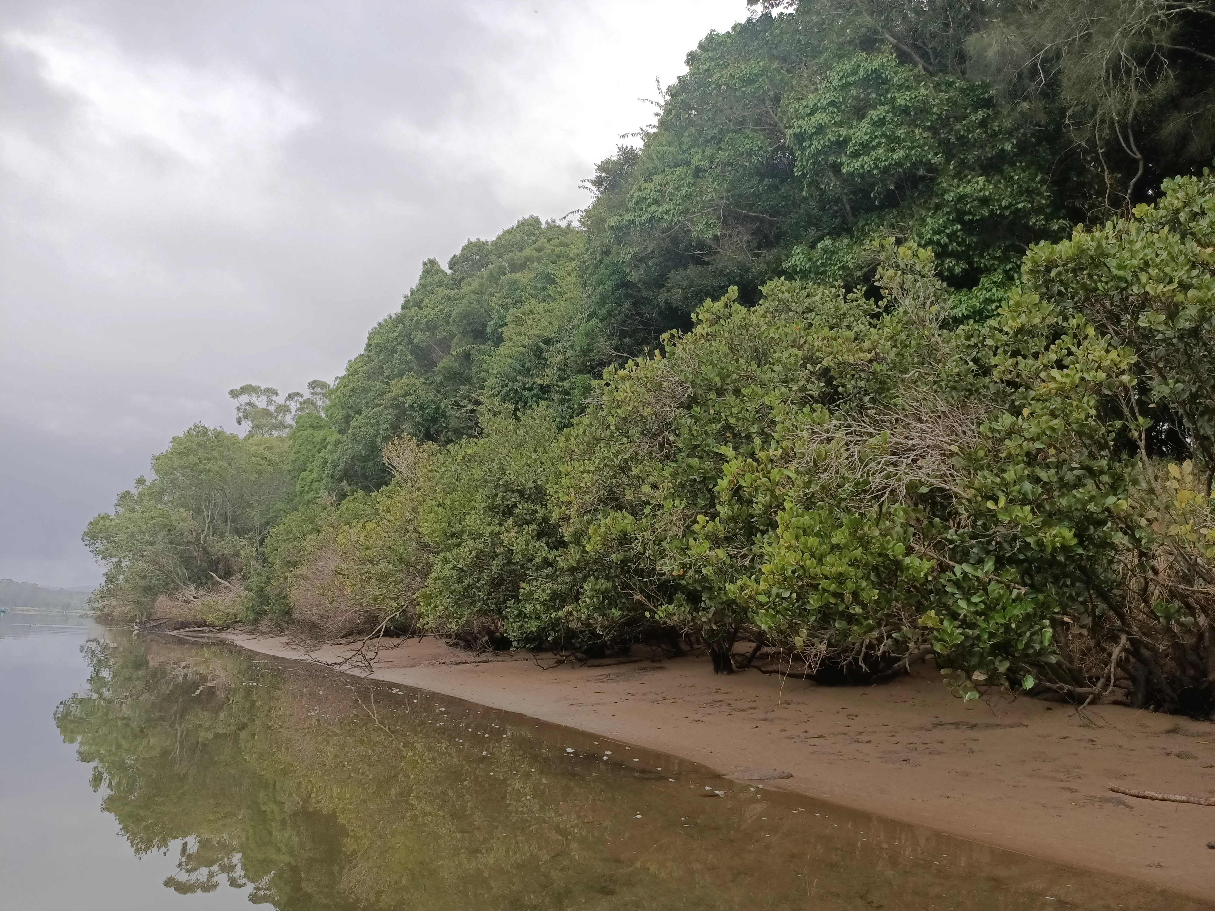
A view along a sandy river bank lined with thick green mangroves and taller trees under a cloudy sky.
The shoreline of Coocumbac Island Nature Reserve, featuring mangroves along the Manning River bank.

Coocumbac Island Nature Reserve history and protected-area timeline

The rainforest on Coocumbac Island has a long history of human use by Aboriginal people of the mid-north coast. In the local Biripi language of the Birrpayi people, the island's name, recorded as Coocumbac, Gukangbang, or Gukangbak, translates to 'meeting place'. Indigenous communities regularly visited the rainforest on the island to collect food and medicinal plants, gather fibres used in making bags and nets, and hold social gatherings. The rainforest also holds spiritual significance for these traditional custodians, a relationship that predates European settlement of the region by many thousands of years.

The reserve itself is a much more recent creation. It was formally gazetted as a nature reserve in September 1981, as part of efforts to protect what remained of the region's subtropical lowland rainforest after extensive clearing for agriculture and housing over preceding decades. The 6-hectare reserve was placed under the management of the NSW National Parks and Wildlife Service and classified within IUCN Category IV, a designation that recognises areas managed primarily for the conservation of particular habitats or species. Management of the small site has included rainforest regeneration programs aimed at encouraging native species and suppressing invasive weeds, and infrastructure work to maintain visitor access, including rebuilding the staircase after flood damage in 2025.

Coocumbac Island Nature Reserve landscape and geographic character

Coocumbac Island is a small river island set in the tidal stretch of the Manning River, on the mid-north coast of New South Wales. Its topography is modest, reflecting its small size of about 6 hectares, but it presents a layered landscape that shifts from water to shoreline to dense forest. The river itself sets the broader context: a coastal river system that links upland forested catchments to estuarine environments and eventually the sea.

The soils of the island are alluvial, deposited by the Manning River over time, and they are enriched by basaltic material washed down from upstream source areas, including the Barrington Tops and the Comboyne and Bulga plateaux. These rich, moisture-retaining soils support the island's rainforest, while the river's tidal influence shapes the mangrove fringe that encircles much of the shoreline.

Around the edge of the island, the landform transitions from water to a narrow band of mangroves, then into taller and denser rainforest. Tall trees, including substantial Moreton Bay figs and other rainforest species, rise above the canopy, providing the most visible landscape feature. The dense interior creates shaded, sheltered conditions, while the river setting opens up broader views across the water toward nearby towns such as Taree. The combination of mangrove shoreline, towering figs, and river backdrop gives the small island a sense of scale far greater than its modest footprint.
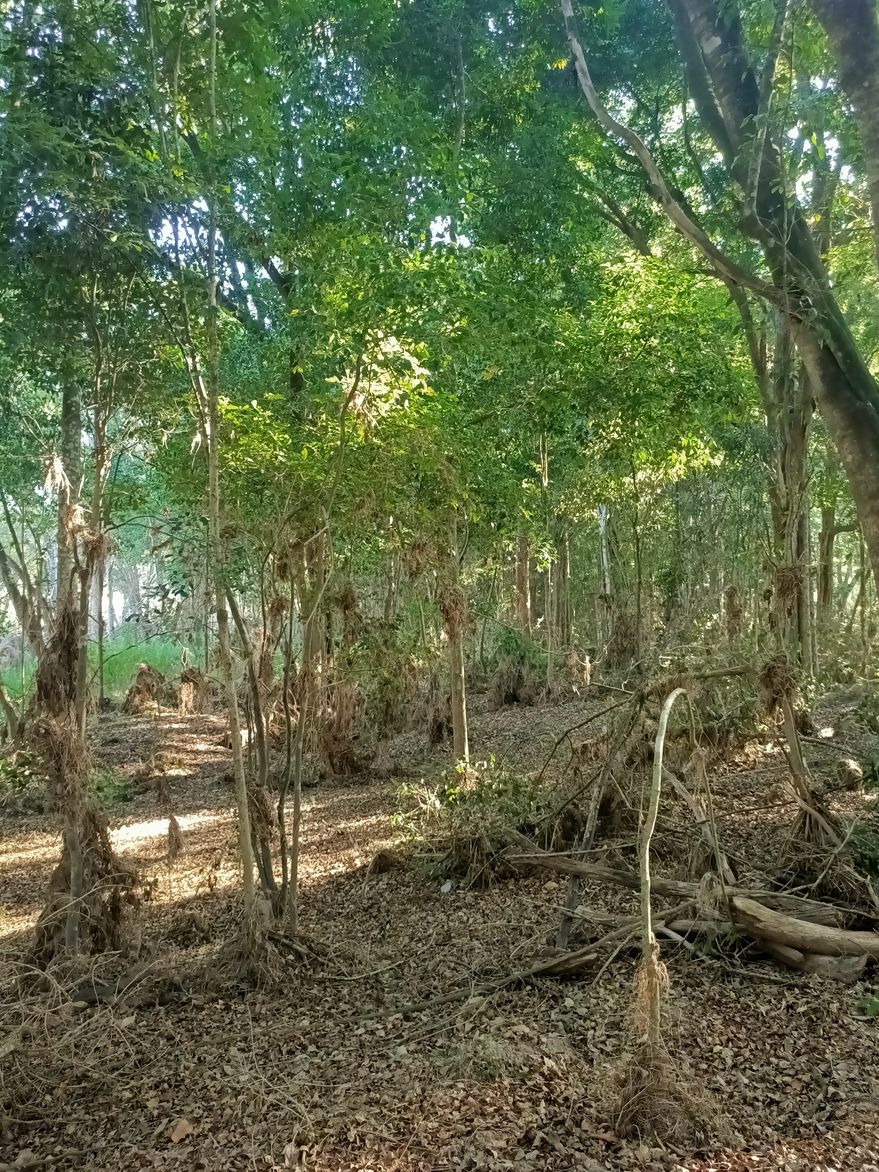
A dense subtropical rainforest scene with tall trees and thick leaf litter on the forest floor, with dappled sunlight filtering through the canopy.
Subtropical lowland rainforest vegetation within Coocumbac Island Nature Reserve.

Coocumbac Island Nature Reserve ecosystems, habitats, and plant life

The defining ecological character of Coocumbac Island Nature Reserve is its rare patch of subtropical lowland rainforest, set within a coastal river landscape. This kind of forest was once more widespread along the New South Wales mid-north coast, but extensive clearing for agriculture and housing has reduced it to scattered remnants, of which Coocumbac Island is one of the better known. The reserve essentially functions as a refugium for rainforest species in a region where such habitat is otherwise scarce.

The island's principal ecological community is known as the large fig and giant stinger tree association, a complex in which fig trees of several species coexist with the stinging tree. Multiple strangler fig species are present, and the most conspicuous are mature Moreton Bay figs, which form emergent trees well above the general canopy. Other fig species contribute to the diversity of the association, along with complementary trees such as native elm, native olive, white walnut, and Australian rose mahogany. The native elm on the island is at its southernmost natural distribution limit, a fact that highlights the reserve's role in conserving species near the edge of their range.

Surrounding the rainforest core is a fringe of mangrove forest, dominated by grey mangrove and river mangrove, which marks the transition between freshwater-influenced rainforest and estuarine mangrove systems. The combination of rainforest and mangrove communities creates a clear ecological layering from the river outward.
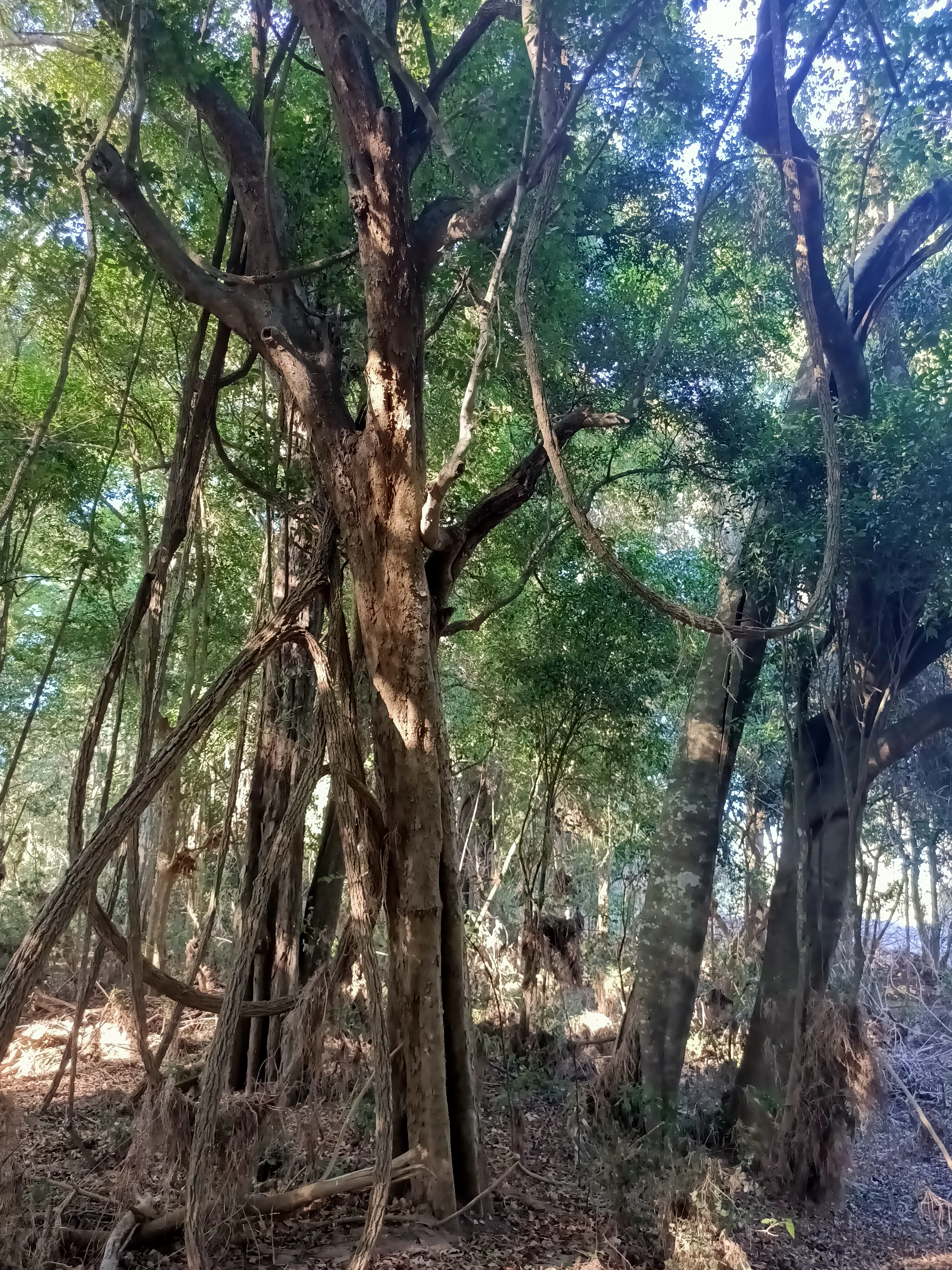
A view looking up at tall trees with thick, hanging vines in a dense forest setting.
Large trees and tangled vines within the subtropical lowland rainforest of Coocumbac Island Nature Reserve.

Coocumbac Island Nature Reserve wildlife and species highlights

Because the island's rainforest is heavily dependent on fig fruiting and on the mosaic of rainforest trees, animal life is closely tied to the forest structure, with fruit-eating species playing a particularly important role. The most conspicuous mammals on the island are grey-headed flying foxes, large fruit bats that roost in the canopy in substantial numbers, with their seasonal presence sometimes reaching into the thousands. These flying foxes feed on figs and other rainforest fruits and are key pollinators and seed dispersers for the island's trees.

The bird life of the reserve reflects its combination of rainforest and river habitat. Notable species include the osprey, a fish-eating raptor associated with the river environment, and the wompoo fruit-dove, a large rainforest pigeon dependent on the fruit of rainforest trees. Together with other fruit-eating and insectivorous birds typical of lowland rainforest in the region, these species give the island a distinctive bird signature, despite its small size. The surrounding river and mangroves broaden the potential range of bird and aquatic fauna visible from or near the island.
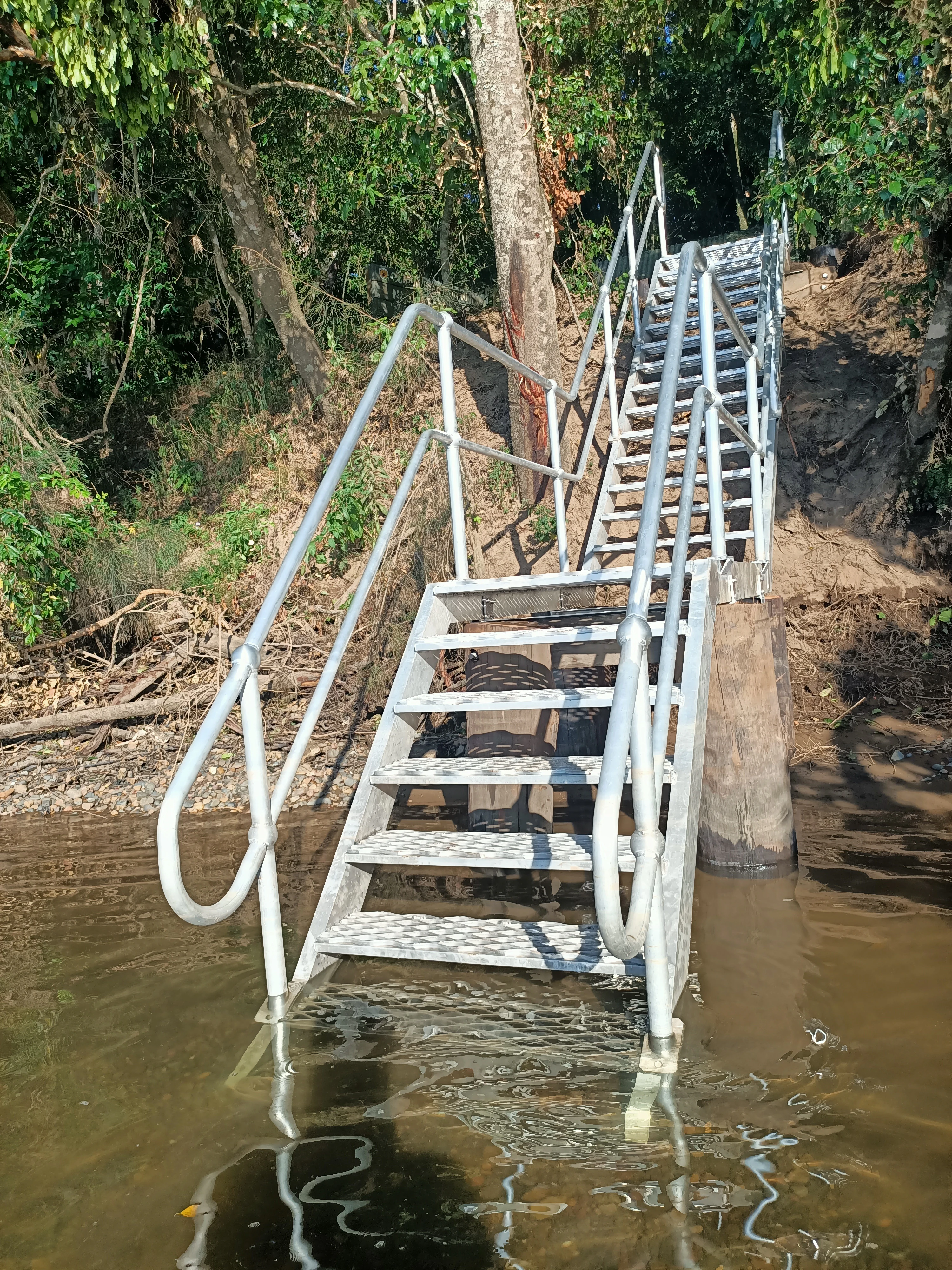
A metal staircase rising out of brown river water, leading up a muddy embankment into a dense forest.
A metal staircase providing water access to Coocumbac Island Nature Reserve from the Manning River.

Coocumbac Island Nature Reserve conservation status and protection priorities

As a protected nature reserve managed by the NSW National Parks and Wildlife Service, Coocumbac Island is recognised under IUCN Category IV as a habitat and species management area, a designation that emphasises active conservation of particular habitats and species rather than purely wilderness protection. The reserve's principal conservation value lies in its preservation of a fragment of subtropical lowland rainforest, an ecological community that has been substantially reduced across the mid-north coast by clearing for agriculture and housing.

The reserve protects a specific ecological assemblage, the large fig and giant stinger tree association, along with associated species such as Moreton Bay figs, native elm at the edge of its range, and a fringe of mangroves. These habitats support species of conservation interest, including large colonies of grey-headed flying foxes, themselves an important subject of conservation concern in eastern Australia, as well as rainforest-dependent birds like the wompoo fruit-dove.

Active management of the reserve includes rainforest regeneration programs designed to encourage native rainforest species and suppress invasive weeds, recognising that small rainforest remnants like Coocumbac Island are vulnerable to being overwhelmed by exotic plants. Aboriginal cultural values are also part of conservation considerations, given the rainforest's longstanding significance to local Indigenous custodians. By safeguarding rainforest habitat, associated wildlife, and cultural heritage on a single island, the reserve plays an outsized role relative to its size in regional biodiversity conservation.

Coocumbac Island Nature Reserve cultural meaning and human context

Coocumbac Island has deep cultural significance for the Aboriginal people of the mid-north coast of New South Wales. The name of the island, rendered in the local Biripi or Birrpayi language as Gukangbang or Gukangbak, translates as 'meeting place', a meaning that reflects the rainforest's long-standing role as a gathering site. Indigenous communities visited the island regularly to collect plant foods and medicinal materials, to harvest fibres used in making bags and nets, and to come together for social occasions.

Beyond practical uses, the rainforest environment of Coocumbac Island carries spiritual importance for traditional custodians, connecting contemporary Aboriginal people to ancestral landscape and cultural practice. Recognition of this Indigenous heritage forms part of how the reserve is understood today, alongside its ecological role, and is part of the broader cultural landscape of the Manning River region.

Top sights and standout views in Coocumbac Island Nature Reserve

Among the reserve's standout features is its rare patch of subtropical lowland rainforest, dominated by an unusual large fig and giant stinger tree association, including prominent Moreton Bay figs and several other strangler fig species. The surrounding mangrove fringe, made up of grey mangrove and river mangrove, is itself an impressive feature on such a small island, giving the site a clear ecological transition from river to rainforest.

Wildlife highlights include seasonal colonies of grey-headed flying foxes numbering in the thousands, along with rainforest-dependent birds such as the wompoo fruit-dove and the osprey along the river. Culturally, the island's Indigenous name meaning 'meeting place' and its long history of Aboriginal use for gathering food, medicine, and fibre give the reserve a depth of significance beyond its modest 6-hectare size.

Best time to visit Coocumbac Island Nature Reserve

Because the reserve protects lowland rainforest on a tidal river island, its character changes with seasonal cycles of rainfall, fruiting, and animal activity. The mid-north coast climate is generally mild and humid, with substantial rainfall throughout the year, and the nearby Taree area receives around 1,176 millimetres of rain annually, so any visit should be prepared for the possibility of wet conditions.

Seasonal variation in wildlife is pronounced. The most visible mammal presence, grey-headed flying foxes, can reach peak numbers of around 5,000 at certain times of the year, making those periods especially notable for observing the island's bat colonies. Fig fruiting cycles, which underpin much of the rainforest food web, vary through the year and influence visiting birds such as the wompoo fruit-dove. Calm, settled weather favours easier access by watercraft and quieter walking conditions on the trail network, while heavy rainfall or flooding events may temporarily affect access, as they did in 2025, when the staircase was damaged and later rebuilt.

Monthly climate preview

Long-term representative temperature and precipitation patterns across the year

Coocumbac Island Nature Reserve Climate Normals and Weather by Month

Representative coordinate records show measured monthly averages ranging from cooler winter lows to warm summer maximums alongside varying daily precipitation rates. Examining the full twelve-month profile provides complete context on long-term thermal and moisture rhythms across the protected area.
Annual mean19 °C
14 °C24 °C
Jan24°
Feb23°
Mar22°
Apr20°
May17°
Jun15°
Jul14°
Aug14°
Sep17°
Oct19°
Nov21°
Dec22°
Warmest month
January

23.8 °C

Coolest month
July

13.6 °C

Wettest month
February

5.4 mm/day

Driest month
August

1.6 mm/day

Park location guide

Geography guide, regional context, and park location map for Coocumbac Island Nature Reserve

Coocumbac Island Nature Reserve park geography, regions, and map view in Australia

Understand where Coocumbac Island Nature Reserve sits in Australia through a broader geographic reading of the surrounding landscape, nearby location context, and its mapped position within the national park landscape.

How Coocumbac Island Nature Reserve fits into Australia

Australia is a constitutional monarchy and federal parliamentary democracy comprising six states and ten territories. With a population of nearly 28 million, it is one of the world's most urbanised countries, with most people concentrated on the eastern seaboard. The country has a high Human Development Index and is known for its cultural diversity, ancient Aboriginal heritage, and unique wildlife.

Wider geography shaping Coocumbac Island Nature Reserve in Australia

Australia occupies the entire Australian continent, the island of Tasmania, and numerous smaller islands. It is the world's flattest and driest inhabited continent, featuring vast deserts in the interior (the Outback), tropical rainforests along the eastern coast, and a coastline bordering the Indian and Pacific Oceans.

Map view of Coocumbac Island Nature Reserve

Use this park location map to pinpoint Coocumbac Island Nature Reserve in Australia, understand its exact geographic position, and read its mapped placement within the surrounding landscape more clearly.

Pigeon | © OpenStreetMap contributors

Location context for Coocumbac Island Nature Reserve

New South Wales

Visualizing subtropical lowland rainforest scenery and river island habitats

Coocumbac Island Nature Reserve Photos and Landscapes

Photographic records capture the dense canopy of Moreton Bay figs and the surrounding mangrove fringe defining Coocumbac Island Nature Reserve. Visual exploration of the protected river environment reveals the unique terrain and rare coastal vegetation of New South Wales.

A view along a sandy river bank lined with thick green mangroves and taller trees under a cloudy sky.

A wooden sign for Coocumbac Island Nature Reserve stands near the edge of the Manning River, with a small staircase leading down to the water surrounded by trees.

A dense subtropical rainforest scene with tall trees and thick leaf litter on the forest floor, with dappled sunlight filtering through the canopy.

A view looking up at tall trees with thick, hanging vines in a dense forest setting.

A metal staircase rising out of brown river water, leading up a muddy embankment into a dense forest.

A wide view of a densely vegetated island surrounded by the blue waters of the Manning River, with a bridge structure partially visible on the far left.

Park atlas

Compare adjacent coastal landscapes, river habitats, and protected lowland rainforest ecosystems

Explore Parks Near Coocumbac Island Nature Reserve and Surrounding Regional Protected Areas

Browse nearby national parks and protected areas sharing the regional environmental context of Coocumbac Island Nature Reserve. Extending geographic comparison helps reveal connected river basins, estuarine habitats, and forest remnants across the mid-north coast.
Nature reserveNew South Wales
About 9 km away#1 closest

Northwest

Wingham Brush Nature Reserve: Protected Rainforest and Manning River Floodplain Geography

An essential ecological sanctuary in coastal New South Wales.

Wingham Brush Nature Reserve represents a critical protected landscape featuring subtropical rainforests on the Manning River floodplain. This unique site, known for its massive Moreton Bay figs and successful regeneration methods, provides a sanctuary for avian and reptilian life amidst the broader coastal plains of eastern Australia.

Area
0.08 km²
Established
2000
IUCN
IV
Relief
Lowland
National parkNew South Wales
About 21 km away#2 closest

North

Coorabakh National Park: A Protected Volcanic Landscape in New South Wales

Discover unique terrain, mapped protected boundaries, and regional geography.

Coorabakh National Park in New South Wales, Australia, is characterized by its striking volcanic trio: Big Nellie, Flat Nellie, and Little Nellie. These peaks dominate the rugged escarpment terrain, offering a unique geographic vista. The park protects a rich mosaic of tall eucalypt forests and sheltered subtropical rainforest gullies, highlighting its ecological diversity. For those interested in atlas-style exploration, Coorabakh National Park provides a clear example of a protected landscape with significant geological and ecological features within the broader regional context of New South Wales.

Area
18 km²
Established
1999
IUCN
II
Relief
Highland
National parkNew South Wales
About 28 km away#3 closest

Northeast

Crowdy Bay National Park: New South Wales Protected Coastal Landscape and Terrain Map

Explore mapped boundaries and diverse natural geography within this national park.

Crowdy Bay National Park offers a compelling example of coastal protected landscape in New South Wales, Australia. This page facilitates a detailed atlas exploration of its natural geography, focusing on the interaction between ocean beaches, headlands, and inland forested terrain. Understand the park's specific location and its characteristic ecosystems, providing a structured view of this significant national park for geographic discovery.

Area
102 km²
Established
1972
IUCN
II
Relief
Lowland
National parkNew South Wales
About 30 km away#4 closest

Northeast

Middle Brother National Park: New South Wales Protected Area and Geographic Exploration

Mapped boundaries and regional landscape context for this national park.

Middle Brother National Park represents a distinct protected landscape within the state of New South Wales, Australia. This entry offers detailed geographic context, focusing on the park's mapped boundaries and its significance as a national park. Users can explore its place within the regional geography of New South Wales, gaining a structured understanding of this protected area through an atlas-focused perspective.

Area
18.3 km²
Established
1999
IUCN
II
Relief
Mountain
A soft watercolor illustration of a rolling landscape with green trees, a dirt path, and a light-filled background.
Nature reserveNew South Wales
About 30 km away#5 closest

North

Killabakh Nature Reserve: Protected Forest Boundaries and Great Dividing Range Geography

Mapped conservation estate in coastal New South Wales

Killabakh Nature Reserve serves as a significant protected land entity within the New South Wales forest network. This site features rugged escarpment terrain dominated by wet sclerophyll eucalyptus and remnant rainforest. Its preservation contributes to long-term ecological connectivity along the Great Eastern Escarpment, showcasing a distinctive botanical profile rooted in the local landscape and regional environmental history.

Area
26.44 km²
Established
1999
IUCN
Ia
Relief
Mountain
National parkMid North Coast
About 32 km away#6 closest

Northwest

Tapin Tops National Park: Protected Landscape in Mid North Coast, Australia

Mapped geographic context and natural terrain discovery.

Tapin Tops National Park is a designated national park offering rich opportunities for geographic and landscape exploration. This detail page provides a structured look at its protected area status and its location within the Mid North Coast region of Australia. Delve into the mapped boundaries and understand the park's specific natural terrain for comprehensive atlas-based discovery.

Area
110 km²
Established
1999
IUCN
II
Relief
Mountain
Nature reserveNew South Wales
About 32 km away#7 closest

North

Boorganna Nature Reserve: Protected Rainforest Mapping and Geographic Overview

Essential geographic context on the Comboyne Plateau in New South Wales

Boorganna Nature Reserve preserves a vital corridor of subtropical and warm temperate rainforest within the Comboyne Plateau of New South Wales. By mapping the deep basalt loams and rugged gully terrain, this overview highlights the reserve as a significant historical refuge for diverse forest types and endemic plant species. Analyze the landscape composition, elevation shifts, and the structural integrity of this protected environmental boundary.

Area
4 km²
Established
1904
IUCN
Ia
Relief
Upland
National parkNew South Wales
About 33 km away#8 closest

South

Booti Booti National Park: New South Wales National Park Protected Landscape Atlas

Mapped boundaries and regional geography for this Australian national park.

Delve into the specifics of Booti Booti National Park, a designated national park within New South Wales, Australia. This resource facilitates a detailed understanding of its protected area status, landscape characteristics, and precise geographic placement. Explore its mapped features and regional context to enrich your atlas-based discovery of Australia's protected lands.

Area
15.67 km²
Established
1992
IUCN
II
Relief
Highland

Common questions about visiting, size, designation, and location context for Coocumbac Island Nature Reserve

Coocumbac Island Nature Reserve FAQs for park facts, access, geography, and protected area context

Find quick answers about Coocumbac Island Nature Reserve, including protected-area facts, park geography, trail and visitor context, and how the park fits into its surrounding country and regional landscape.
MoriAtlas Explorer

Continue Your Protected Areas Search Across the Global Atlas

Deepen your exploration by continuing the structured search for national parks and protected areas worldwide. Utilize the comprehensive filtering capabilities to compare different conservation landscapes and refine your understanding of global park geography. Discover more about the distribution and characteristics of protected natural areas.

Global natural geography