Mori Atlas logo
Protected landscapeCorroboree Rock Conservation Reserve

Ancient dolomite geological heritage and sacred sites in the arid central Australian terrain

Corroboree Rock Conservation Reserve: A Protected Landscape within the East MacDonnell Ranges

Corroboree Rock Conservation Reserve represents a significant protected area within the East MacDonnell Ranges of the Northern Territory. Centered on a prominent grey dolomite column, this landscape preserves geological features from the ancient Bitter Springs formation alongside deep cultural associations for the Eastern Arrernte people. The reserve stands as a distinct island of conserved natural heritage amidst the expansive pastoral landscapes east of Alice Springs.

aboriginal sacred sitedolomite rockmacDonnell rangescentral australiaarid range countrysmall conservation reserve

Corroboree Rock Conservation Reserve

Protected landscape

Park overview

Structured park overview, official facts, and landscape profile for Corroboree Rock Conservation Reserve

Corroboree Rock Conservation Reserve park facts, protected area profile, and essential visitor context

Review the core facts for Corroboree Rock Conservation Reserve, including designation, size, terrain, visitor scale, habitats, and operating context in one park-focused overview.

About Corroboree Rock Conservation Reserve

Corroboree Rock Conservation Reserve is a compact but meaningful protected area in central Australia's Northern Territory, set within the East MacDonnell Ranges east of Alice Springs. While small in area, the reserve carries layered significance that combines geology, arid environment ecology, and Aboriginal cultural heritage, making it stand out in the regional protected-area network.

The defining feature of the reserve is a striking column of grey dolomite rock that rises from the surrounding range country. Europeans historically referred to this feature as Corroboree Rock, while in the Eastern Arrernte language it is known as Pwenye. The rock itself is more than just a landmark; it is regarded as a sacred site by the Eastern Arrernte people, who are the Traditional Owners of the area and who consider themselves linked to the rock as part of their country.

Beyond its cultural profile, the reserve holds notable geological interest. The dolomite belongs to the Bitter Springs formation, a sedimentary sequence deposited in evaporitic salt lake environments deep in the Precambrian, far older than most landscape features a visitor might associate with central Australia. This combination of cultural meaning and ancient geological context gives Corroboree Rock a distinctive identity despite the reserve's modest size.

The surrounding land use adds further texture to the site. The reserve is enclosed by the Undoolya pastoral lease, an active cattle station whose history shapes the land context around the rock. The reserve's formal protection since 1962 reflects long-running recognition of the site's importance, and its ongoing management by the Parks and Wildlife Commission of the Northern Territory reflects continued stewardship within a broader working pastoral landscape.

Quick facts and research context for Corroboree Rock Conservation Reserve

Corroboree Rock Conservation Reserve is a small protected area in the Northern Territory of Australia, situated about 42 kilometres east of Alice Springs in the East MacDonnell Ranges. It was established in 1962 and is managed by the Parks and Wildlife Commission of the Northern Territory, covering roughly 7 hectares. The reserve is classified as IUCN Category V, recognising it as a protected landscape with strong cultural and natural values.

Protection and recognition

Documented terrestrial protection scope and conservation designation records

Corroboree Rock Conservation Reserve Protection Status and Recognition

Corroboree Rock Conservation Reserve maintains a recorded terrestrial protection scope within the official geographic database. Documented protection status details provide verified parameters regarding administrative designation and management scope for this protected landscape.

Protection details

Protection scope
Terrestrial
Transboundary protection
No
Park context

Deeper park guide and search-rich context for Corroboree Rock Conservation Reserve

Corroboree Rock Conservation Reserve history, landscape, wildlife, and travel context

Explore Corroboree Rock Conservation Reserve through its history, landscape character, ecosystems, wildlife, conservation priorities, cultural context, and seasonal travel timing in a structured park guide built for atlas discovery and search intent.

Why Corroboree Rock Conservation Reserve stands out

The reserve is best known for the prominent column of grey dolomite rock that forms its central feature and lends the protected area its name. The rock is a sacred site of significance to the Eastern Arrernte Traditional Owners and is referred to in the Eastern Arrernte language as Pwenye. Geologically, the rock belongs to the Bitter Springs formation, with origins tied to sediments deposited in shallow Precambrian salt lakes around 800 million years ago, adding deep-time natural history value to what is otherwise a very small reserve.
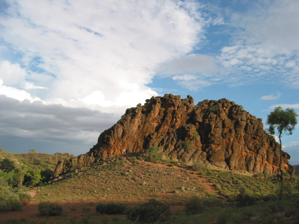
A large, jagged outcrop of dark orange and grey dolomite rock sits prominently in a desert landscape under a blue sky with scattered clouds.
The distinctive dolomite formation of Corroboree Rock in the Northern Territory.

Corroboree Rock Conservation Reserve history and protected-area timeline

Corroboree Rock Conservation Reserve was formally established in 1962 as a protected area in the Northern Territory of Australia, recognising the cultural and natural significance of the dolomite rock feature at its centre. The site has long been important to the Eastern Arrernte people as a sacred place, and its protection formalised a relationship between the land, its Traditional Owners, and broader public recognition.

The reserve's setting within the Undoolya pastoral lease places it within a long-running history of cattle grazing in the East MacDonnell Ranges area. While the pastoral lease continues to operate as a working cattle station, the reserve itself has been set aside under a different management framework, reflecting the way small but culturally important sites have been ring-fenced within broader grazing land in central Australia.

Historical photographs of Corroboree Rock, dating back to the mid-twentieth century, illustrate that the rock has long been recognised as a distinctive landmark in the ranges east of Alice Springs. Its eventual inclusion in the Northern Territory's system of conservation reserves reflects an evolving approach to protecting sites that hold both Aboriginal cultural values and notable geological character.

Corroboree Rock Conservation Reserve landscape and geographic character

The landscape of Corroboree Rock Conservation Reserve is defined by the East MacDonnell Ranges environment east of Alice Springs, a region characterised by rocky ridges, spinifex-covered slopes, and arid range country typical of central Australia. The reserve's central feature is a column of grey dolomite that rises prominently from the surrounding terrain, giving the area a memorable visual identity despite the reserve's small size.

The broader setting is shaped by ancient sedimentary geology. The rock belongs to the Bitter Springs formation, a sequence of rocks linked to salt lake environments that existed in the region hundreds of millions of years ago. This means that although the surface landscape looks typically arid and rocky, the underlying geological history gives the area a much deeper time depth than casual observation would suggest.

Surrounding the reserve, the Undoolya pastoral lease presents a largely open pastoral landscape of grazing land, which frames the protected area as a small island of formally conserved terrain within a working cattle landscape. The transition from pastoral land into the rocky outcrop and its associated vegetation defines the visual rhythm of the area.

Corroboree Rock Conservation Reserve ecosystems, habitats, and plant life

Ecologically, Corroboree Rock Conservation Reserve fits within the arid range country ecosystems typical of central Australia. The vegetation reflects adaptations to a dry, rocky environment, with plant communities varying between the exposed ridges and the sheltered base of the dolomite formation.

On the upper ridges and exposed rocky ground, hardy and drought-adapted species such as spinifex grasses and senna shrubs are characteristic. Around the base of the rock, where soils tend to accumulate and moisture is slightly more available, the vegetation shifts to include scattered eucalypts such as bloodwood, along with other small trees and shrubs including Red Mallee, Supplejack, and Whitewood. This contrast between exposed ridge vegetation and sheltered base vegetation reflects the typical ecological zonation seen around isolated rock formations in arid Australian landscapes.

As a small reserve embedded within a larger pastoral landscape, the area provides a localised refuge for native vegetation patterns that may otherwise be affected by grazing pressure on the surrounding lease land. The reserve's modest size concentrates ecological value into a narrow zone defined largely by the presence of the rock itself.

Corroboree Rock Conservation Reserve wildlife and species highlights

While the reserve's small size limits its capacity to support large wildlife populations, the habitat mosaic of rocky outcrop, ridge spinifex, and base-of-rock tree cover is consistent with the kinds of small fauna typical of central Australian range country. Reptiles, small mammals, and arid-adapted birdlife are part of the expected ecological community in this type of habitat.

The juxtaposition of rocky shelter, spinifex cover, and scattered eucalyptus woodland provides a microhabitat structure that supports the kind of small-scale wildlife movements characteristic of similar East MacDonnell Ranges sites. However, the available source material for the reserve is limited and does not detail specific confirmed species records at the reserve itself, so broader inferences should be treated cautiously.

Corroboree Rock Conservation Reserve conservation status and protection priorities

The reserve's conservation significance lies less in its size than in what it contains and represents. At only a few hectares, Corroboree Rock Conservation Reserve is one of the smaller formal protected areas in the Northern Territory, but the cultural importance of the rock to the Eastern Arrernte people and the geological value of the Bitter Springs formation dolomite combine to give the site meaning beyond its footprint.

Classified under IUCN Category V, the reserve sits within the broader international recognition of protected landscapes and seascapes that combine natural and cultural values. Its formal protection since 1962 reflects long-standing recognition of these values, and its ongoing management by the Parks and Wildlife Commission of the Northern Territory helps ensure that grazing pressure and other land-use impacts from the surrounding pastoral lease do not directly affect the protected core.

In a regional sense, the reserve also contributes to the layered identity of the East MacDonnell Ranges as a landscape where geological heritage, Aboriginal cultural heritage, and pastoral history overlap. Even as a small node within that broader landscape, the reserve holds an outsized symbolic role as a place where ancient rock, enduring culture, and modern conservation come together.

Corroboree Rock Conservation Reserve cultural meaning and human context

The cultural foundation of Corroboree Rock Conservation Reserve is the deep connection between the rock and the Eastern Arrernte people, who are the Traditional Owners of the area. In the Eastern Arrernte language, the rock is known as Pwenye, and this name carries significance beyond a simple label; it is also used by the Eastern Arrernte to describe themselves as being part of their country. The site is regarded as a sacred location, embedding Aboriginal heritage directly into the identity of the reserve.

The reserve sits within the broader cultural geography of the Arrernte homelands around Alice Springs, where individual landscape features such as rock outcrops, waterholes, and ranges carry long-standing stories, responsibilities, and meanings. The formal protection of this rock as a conservation reserve reflects a public recognition of cultural values that predate European interest in the area by many generations.

Alongside this Aboriginal cultural context, the reserve is also wrapped in the more recent layer of European and pastoral history associated with the surrounding Undoolya pastoral lease. This combination of Aboriginal cultural significance, early European exploration histories, and long-running pastoral land use makes the area a small but layered cultural landscape.

Top sights and standout views in Corroboree Rock Conservation Reserve

The standout highlights of Corroboree Rock Conservation Reserve cluster around a few distinct qualities: the grey dolomite column of cultural and visual importance, the Eastern Arrernte name Pwenye and the rock's role as a sacred site, the Bitter Springs formation geology with origins in ancient salt lake environments, and the reserve's place within the East MacDonnell Ranges east of Alice Springs. The contrast with the surrounding Undoolya pastoral lease adds further texture, showing how a small cultural and geological protected site sits within a broader working pastoral landscape.

Best time to visit Corroboree Rock Conservation Reserve

The reserve sits within central Australia's arid range country, where seasonal conditions strongly shape the experience of visiting remote outcrops. Cooler months typically offer more comfortable conditions for outdoor time in this part of the Northern Territory, while hotter periods can be harsh in the open range environment. Wildlife observation and the experience of the rock itself are less season-sensitive than the comfort of accessing the site, and visitors should expect typical central Australian desert conditions at any time of year.
Monthly climate preview

Long-term monthly temperature and precipitation patterns across the conservation reserve

Corroboree Rock Conservation Reserve Climate Normals and Annual Temperature Rhythm

Representative coordinate records show average temperatures ranging from mild winter minimums to extreme summer maximums alongside low daily precipitation rates throughout the year. Examining the complete monthly climate profile reveals detailed temperature curves and precipitation normals for the entire conservation reserve.
Annual mean22 °C
12 °C30 °C
Jan30°
Feb28°
Mar26°
Apr22°
May16°
Jun13°
Jul12°
Aug15°
Sep20°
Oct24°
Nov27°
Dec29°
Warmest month
January

29.8 °C

Coolest month
July

12.4 °C

Wettest month
January

1.8 mm/day

Driest month
August

0.1 mm/day

Park location guide

Geography guide, regional context, and park location map for Corroboree Rock Conservation Reserve

Corroboree Rock Conservation Reserve park geography, regions, and map view in Australia

Understand where Corroboree Rock Conservation Reserve sits in Australia through a broader geographic reading of the surrounding landscape, nearby location context, and its mapped position within the national park landscape.

How Corroboree Rock Conservation Reserve fits into Australia

Australia is a constitutional monarchy and federal parliamentary democracy comprising six states and ten territories. With a population of nearly 28 million, it is one of the world's most urbanised countries, with most people concentrated on the eastern seaboard. The country has a high Human Development Index and is known for its cultural diversity, ancient Aboriginal heritage, and unique wildlife.

Wider geography shaping Corroboree Rock Conservation Reserve in Australia

Australia occupies the entire Australian continent, the island of Tasmania, and numerous smaller islands. It is the world's flattest and driest inhabited continent, featuring vast deserts in the interior (the Outback), tropical rainforests along the eastern coast, and a coastline bordering the Indian and Pacific Oceans.

Map view of Corroboree Rock Conservation Reserve

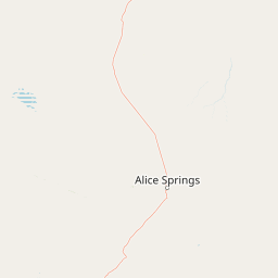
Use this park location map to pinpoint Corroboree Rock Conservation Reserve in Australia, understand its exact geographic position, and read its mapped placement within the surrounding landscape more clearly.

Pigeon | © OpenStreetMap contributors

Location context for Corroboree Rock Conservation Reserve

Northern Territory

Visual reference guide for the dolomite column and surrounding terrain

Corroboree Rock Conservation Reserve Photos and Arid Range Landscapes

Examine detailed photographs of Corroboree Rock Conservation Reserve to understand its prominent grey dolomite column and rugged arid range surroundings. Visual records reveal the unique interface between ancient geological formations and the open pastoral terrain of central Australia.

A large, jagged outcrop of dark orange and grey dolomite rock sits prominently in a desert landscape under a blue sky with scattered clouds.

Park atlas

Compare surrounding arid range country reserves and regional conservation areas.

Parks Near Corroboree Rock Conservation Reserve and Regional Protected Landscapes

Browse other protected areas situated across the arid terrain and ancient geological formations surrounding Corroboree Rock Conservation Reserve. Comparing adjacent Northern Territory reserves reveals broader patterns in central Australian conservation geography.
A wide watercolor illustration showing a winding river or creek bed flanked by green trees, with pink and red rocky hills in the background under a pale sky.
Nature reserveNorthern Territory
About 25 km away#1 closest

East

N'Dhala Gorge Nature Park: Mapped Geography and Protected Cultural Heritage

Nature reserve located in the eastern MacDonnell Ranges

This nature reserve protects a vital valley corridor in the Northern Territory where sandstone ridges and sandy terrain meet. The park serves as a repository for approximately 6,000 ancient petroglyphs and sustains specialized arid plant species. Use this resource to understand the park's structural boundaries and its place within the broader geography of Central Australia.

Area
5.01 km²
Established
1962
IUCN
V
Relief
Mountain
Protected landscapeNorthern Territory
About 25 km away#2 closest

Northeast

Trephina Gorge Nature Park: Mapped Geography and Protected Landscape Context

East MacDonnell Ranges, Northern Territory Australia

Trephina Gorge Nature Park represents a central feature of the arid MacDonnell Ranges, characterized by its deep gorge, white ghost gums against red rock, and expansive spinifex ridges. This record outlines the park boundaries, its role as a jointly managed conservation area, and its position within the broader geography of central Australia.

Established
1965
Relief
Mountain
Climate
Arid
Access
Access unknown
National parkNorthern Territory
About 35 km away#3 closest

West

Tjoritja / West MacDonnell National Park: National Park Atlas and Protected Landscape

Explore the dramatic MacDonnell Ranges terrain and geography.

Delve into the protected geography of Tjoritja / West MacDonnell National Park, a significant national park in Australia's Northern Territory. This landscape features striking mountain formations, deep gorges like Standley Chasm and Glen Helen, and is intrinsically linked to the famous Larapinta Trail and the Arrernte people's cultural heritage. Understanding its mapped boundaries and regional context provides essential insight into this iconic Central Australian protected area.

Area
2,568.61 km²
Established
1992
IUCN
II
Relief
Mountain
Watercolor painting of a soft, abstract landscape with a line of trees against rolling hills and light, hazy colors.
Nature reserveNorthern Territory
About 46 km away#4 closest

Southwest

Napwerte / Ewaninga Rock Carvings Conservation Reserve: Protected Desert Landscape Map

Cultural heritage and arid basin geography in the Northern Territory

Napwerte / Ewaninga Rock Carvings Conservation Reserve protects a unique desert site defined by its extensive collection of prehistoric Arrernte rock engravings. The landscape encompasses rocky outcrops, red sand dunes, and a seasonal claypan that captures rare rainfall, creating a significant intersection of archaeological history and arid-zone ecology in central Australia.

Area
0.06 km²
Established
1970
IUCN
V
Relief
Lowland
Wildlife reserveNorthern Territory
About 47 km away#5 closest

West

Kuyunba Conservation Reserve: Wildlife Protected Landscape in Central Australia

Mapped geography and rocky habitat near Alice Springs

Kuyunba Conservation Reserve represents a focused approach to habitat protection in the Northern Territory. The terrain is defined by its rocky hills and boulder-filled escarpments, offering critical shelter for wildlife in an arid, drought-adapted desert region. This site provides a clear view of how targeted land management supports specialized ecological niches in inland Australia.

Area
6.29 km²
Established
1970
IUCN
V
Relief
Upland
Protected areaNorthern Territory
About 57 km away#6 closest

Northeast

Arltunga Historical Reserve: A Heritage Protected Area in Northern Territory Australia

Mapping nineteenth century mining ruins and arid terrain

Arltunga Historical Reserve offers a distinct window into the outback mining era through its well-preserved stone structures and desolate desert setting. This protected area within the Northern Territory highlights the intersection of European settlement history and the traditional cultural heritage of the Eastern Arrernte people.

Area
50 km²
Established
1975
Relief
Upland
Climate
Arid
A wide, panoramic watercolor painting showing a soft landscape with rolling hills in the background, green trees and bushes in the midground, and a pinkish path or river in the foreground.
Protected areaNorthern Territory
About 85 km away#7 closest

East

Ruby Gap Nature Park: Geography and Protected Wilderness in the Northern Territory

Gorge-carved arid landscapes and historical mining heritage

Ruby Gap Nature Park stands as a remote protected area in the heart of Australia's Northern Territory. Defined by the Hale River gorge, the terrain showcases dramatic cliff lines, expansive rocky flats, and rich geological sites that reveal a layered story of Indigenous heritage and 19th-century boom-and-bust mining history. Explore the park boundary and the surrounding East MacDonnell Ranges through this focused geographic overview.

Area
92.57 km²
Relief
Upland
Climate
Arid
Access
Remote access
A horizontal watercolor painting showing stylized soft green, orange, and pale yellow hills under a white sky.
Nature reserveNorthern Territory
About 92 km away#8 closest

Southwest

Rainbow Valley Conservation Reserve: Geological Atlas and Protected Landscape Mapping

Examining the arid-zone terrain of Northern Territory, Australia.

The Rainbow Valley Conservation Reserve is a significant protected landscape known for its 350-million-year-old banded sandstone bluffs and diverse arid-zone habitats. This overview provides a focused look at the park's geological structure, claypan terrain, and its status as a vital site for Aboriginal heritage, offering a clear understanding of its place within the broader Northern Territory geographic context.

Area
24.83 km²
Established
1990
IUCN
V
Visitors
6.8K annual

Common questions about visiting, size, designation, and location context for Corroboree Rock Conservation Reserve

Corroboree Rock Conservation Reserve FAQs for park facts, access, geography, and protected area context

Find quick answers about Corroboree Rock Conservation Reserve, including protected-area facts, park geography, trail and visitor context, and how the park fits into its surrounding country and regional landscape.
MoriAtlas Explorer

Continue Your Protected Areas Search Across the Global Atlas

Deepen your exploration by continuing the structured search for national parks and protected areas worldwide. Utilize the comprehensive filtering capabilities to compare different conservation landscapes and refine your understanding of global park geography. Discover more about the distribution and characteristics of protected natural areas.

Global natural geography