Mori Atlas logo
Protected landscapeCygański Las

A vital urban-edge mountain gateway connecting local forest corridors to the Silesian Beskids ridgeline.

Cygański Las Protected Landscape: Geographic Mapping and Forest Terrain in Bielsko-Biała, Poland

(Zespół przyrodniczo-krajobrazowy „Cygański Las”)

Cygański Las represents a significant protected landscape complex spanning 593 hectares on the southern slopes of Bielsko-Biała. This forested terrain acts as a transitional foothill belt between the urban basin and the Silesian Beskids. Users can trace mapped boundaries across the hillsides of Kołowrót, Kozia Góra, Równia, and Górna Równia, exploring a mosaic of Carpathian beech, oak-hornbeam, and mountain sycamore communities within this historic woodland.

urban-edge forestCarpathian beech forestsubcontinental oak-hornbeam forestmountain sycamore standprotected landscape complexSilesian Beskids

Cygański Las

Protected landscape

Park overview

Structured park overview, official facts, and landscape profile for Cygański Las

Cygański Las park facts, protected area profile, and essential visitor context

Review the core facts for Cygański Las, including designation, size, terrain, visitor scale, habitats, and operating context in one park-focused overview.

About Cygański Las

Cygański Las is a protected forest landscape on the southern edge of Bielsko-Biała, the largest city in the Polish part of the Cieszyn Silesia region. It occupies the lower mountain slopes of the Silesian Beskids, transitioning from the densely built urban districts of Olszówka and Mikuszowice into wilder hillside terrain. Within the city's geography, Cygański Las acts as a green wedge, linking residential neighborhoods directly to traditional hiking routes into the higher Beskids.

The forest has been part of Bielsko's documented history since 1312, when Mieszko cieszyński granted this woodland to the citizens of Bielsko in one of the earliest known written references to the settlement. Over the following centuries it functioned alternately as a communal pasture, a contested resource between the townspeople and neighboring landlords, and eventually as a depleted woodland that was largely depleted and then re-planted in the 19th century. In the second half of the 19th century the lower portion of Cygański Las was transformed, under the influence of director Karol Ambroży and the local Verschönerungsverein civic society, into a forest park inspired by the Wienerwald, the Vienna Woods. That redesign encouraged Mikuszowice Śląskie to develop as a fashionable summer resort with villas, walking paths, restaurants, and inns.

In the 20th century, the tram line that once terminated right next to the forest was removed in 1971, and Mikuszowice Śląskie was incorporated into Bielsko-Biała in 1968, while the upper portion of the forest only joined the city in 1990. Formal nature protection arrived in 1997, when a zespoł przyrodniczo-krajobrazowy was established under the name Cygański Las; in 2004 its area was reduced from the original 925 hectares to 593 hectares. Despite this reduction, the remaining protected area still harbors well-preserved forest communities and forms a continuous ecological corridor with the surrounding Beskid slopes. A portion of the forest, particularly toward Kołowrót, lies within the larger Park Krajobrazowy Beskidu Śląskiego, extending protected status at the broader landscape level.

Quick facts and research context for Cygański Las

Cygański Las covers an area of approximately 593 hectares within the city of Bielsko-Biała, in the Silesian Voivodeship of southern Poland. It has been formally protected as a zespoł przyrodniczo-krajobrazowy since 1997, with its present boundaries confirmed in 2004. Part of the forest is also enclosed within the broader Park Krajobrazowy Beskidu Śląskiego, the Silesian Beskids Landscape Park.

Geographically, the area belongs to the Silesian Beskid mesoregion and stretches across the slopes of Kołowrót, Kozia Góra, Równia, and Górna Równia. Natural communities documented in the area include fertile Carpathian beech forest, sub-mountain sycamore ash floodplain forest, subcontinental oak-hornbeam forest, and a characteristic mountain sycamore stand with perennial honesty.

Protection and recognition

Explore the terrestrial protection framework and formal designation records for Cygański Las.

Cygański Las Protection Status and Documented Conservation Scope

Cygański Las maintains a documented terrestrial protection scope detailing its official conservation framework and management boundaries. Structured records outline the baseline designation metrics and administrative context governing this protected area.

Protection details

Protection scope
Terrestrial
Transboundary protection
No
Park context

Deeper park guide and search-rich context for Cygański Las

Cygański Las history, landscape, wildlife, and travel context

Explore Cygański Las through its history, landscape character, ecosystems, wildlife, conservation priorities, cultural context, and seasonal travel timing in a structured park guide built for atlas discovery and search intent.

Why Cygański Las stands out

Cygański Las is best known as one of the closest large forested areas to central Bielsko-Biała, combining protected natural habitat with a long-established hiking gateway into the Silesian Beskids. Its trails connect directly to prominent summits such as Szyndzielnia, Klimczok, and Magurka Wilkowicka, making it a familiar starting point for both casual walks and longer mountain excursions. The protected landscape is also notable for the presence of several distinct natural forest communities on a relatively compact urban-adjacent site. These include fertile Carpathian beech forest, sub-mountain ash floodplain forest, subcontinental oak-hornbeam forest, and a rare mountain sycamore stand with miesiącznica trwała, lending the area genuine botanical significance beyond its recreational role.
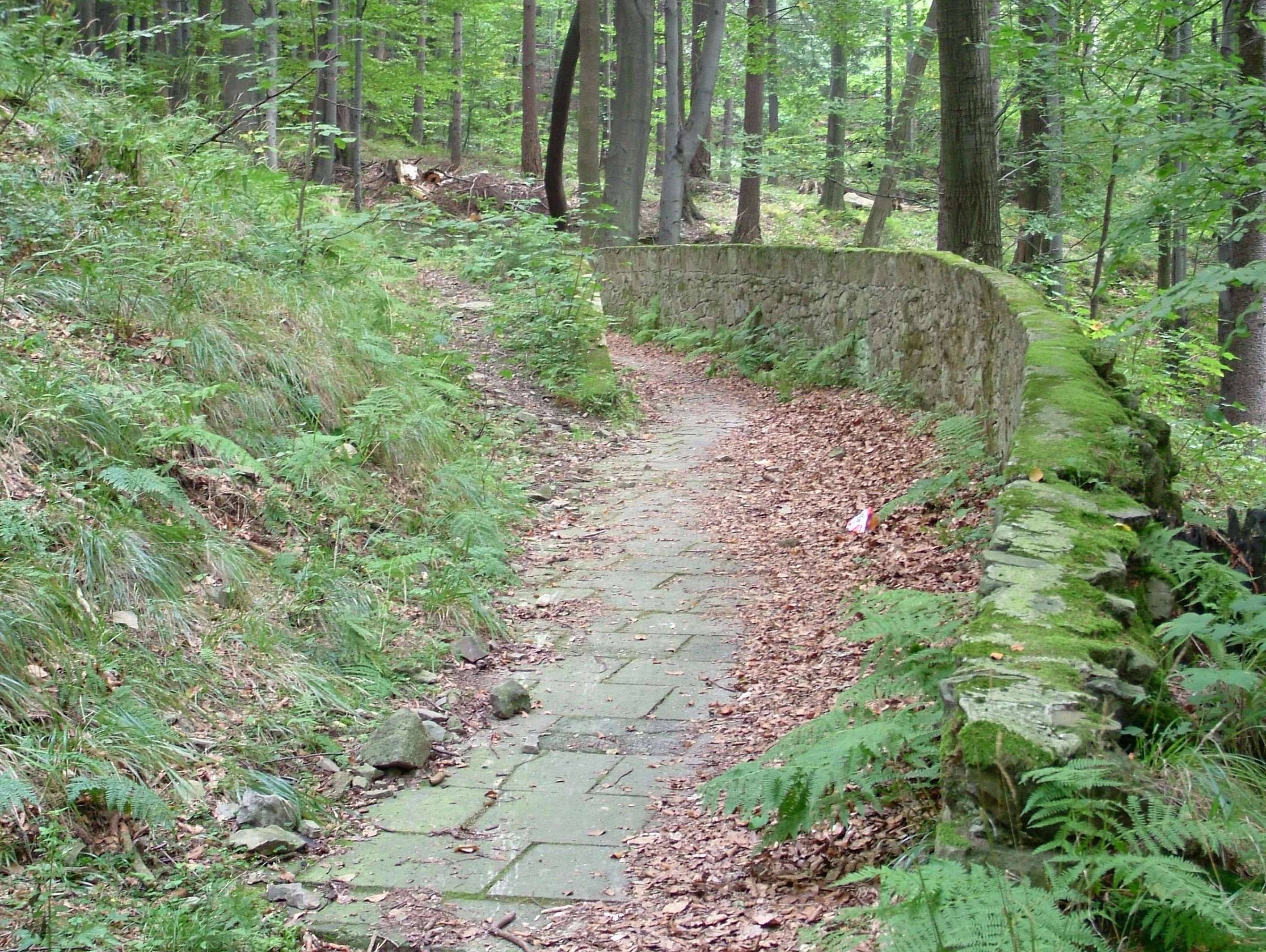
An old, narrow concrete toboggan or bobsleigh track with a stone wall along one side, winding through a dense green forest, covered in scattered brown leaves.
A segment of an abandoned historic concrete toboggan track winding through the beech forests of Kozia Gora.

Cygański Las history and protected-area timeline

Cygański Las is one of the oldest documented features of the landscape around Bielsko. The earliest written record dates to 1312, when Mieszko cieszyński formally granted the forest stretching from Mikuszowice toward Kamienica to the burghers of Bielsko; this document is also considered the oldest known written mention of the town itself. Throughout the medieval and early modern period the forest was a shared civic resource, used for grazing and timber.

In 1548, Wacław III Adam permitted a cleared portion of the forest to be used as a municipal pasture, marking one of the earliest formal recognitions of its communal role. By the 17th century the forest had become a source of conflict between the citizens of Bielsko and the leaseholder of the łodygowice estate, the castellan Stanisław Warszycki; the dispute escalated to armed intervention by Austrian troops in 1644. Continuous exploitation during this period severely damaged the original tree cover, and the forest was largely re-planted during the 19th century.

A second chapter began in the 1860s, when the lower section of the forest was redesigned under the direction of Karol Ambroży and the local Verschönerungsverein society into a recreational forest park modeled on the Wienerwald, the Vienna Woods. This intervention supported the development of Mikuszowice Śląskie as an upper-class summer resort, complete with summer villas, walking paths, and catering establishments. A dedicated tram line reached the edge of the forest in 1895, though it was removed in 1971. Mikuszowice Śląskie, including the lower forest, was incorporated into Bielsko-Biała in 1968, while the upper portion remained part of the neighboring municipality of Bystra until 1990.

A final layer of history is ideological. During the communist era the forest was briefly renamed Park Ludowy, "People's Park," before reverting to its older name. In 1997, the contemporary protected designation, zespoł przyrodniczo-krajobrazowy, was established over 925 hectares; this was reduced to 593 hectares in 2004 following legal changes and opposition from developers. Portions of the forest toward Kołowrót are simultaneously protected within the boundaries of the Park Krajobrazowy Beskidu Śląskiego, the Silesian Beskids Landscape Park.

Cygański Las landscape and geographic character

Cygański Las occupies the lower slopes of the Silesian Beskids, on the city-facing side of Bielsko-Biała. Its terrain rises from the residential edges of Olszówka and Mikuszowice up the hillsides of Kołowrót, Kozia Góra, Równia, and Górna Równia, four connected elevations that form a transitional foothill belt between the urban basin and the higher Beskid ridges.

The relief is typical of the outer Carpathian foothills: rounded, forested ridges; deep valley incisions carrying small mountain streams; and a mosaic of slopes with varying exposure. Because the area sits at the meeting point of inner-city districts and open mountain terrain, its landscape contains both heavily landscaped recreation zones, especially in the historically redesigned lower section, and wilder woodland climbing toward the ridgeline.

To the north and east, the forest frames the residential fabric of southern Bielsko-Biała; to the south and west, it opens into the broader mountain landscape of the Silesian Beskids and connects visually with the higher peaks of Szyndzielnia, Klimczok, and Magurka Wilkowicka. This combination of urban proximity and mountain context gives Cygański Las a distinctive transitional character, neither fully urban park nor remote wilderness.
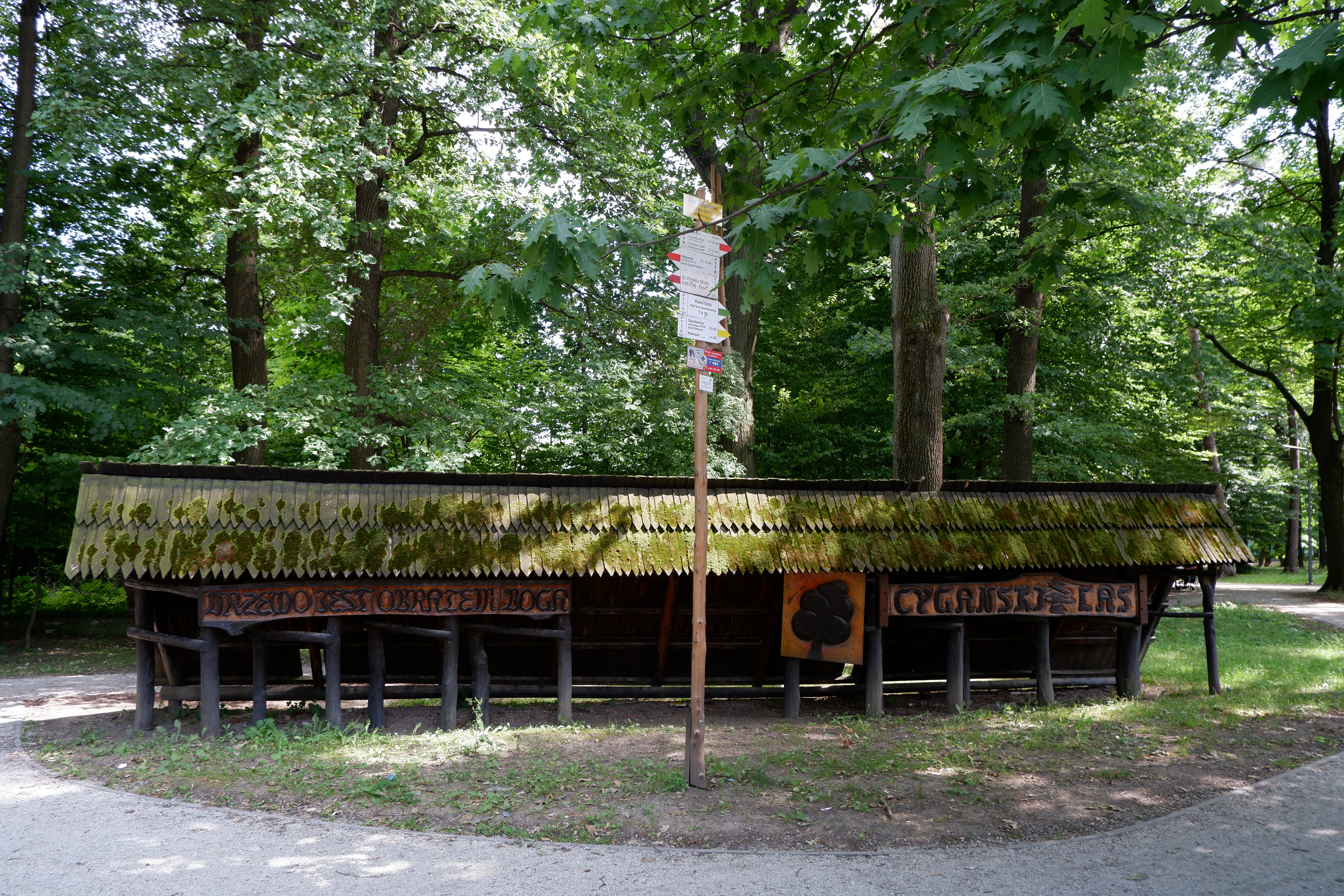
A long, wooden, mossy-roofed resting shelter sits along a trail in a dense green forest, with a tall wooden trail signpost standing in front of it.
A wooden resting shelter and trail signpost within the Cygański Las forest park.

Cygański Las ecosystems, habitats, and plant life

Despite its proximity to the city, Cygański Las harbors a surprisingly diverse set of natural forest communities. Botanically, the area is documented as including fertile Carpathian beech forest (żyzna buczyna karpacka), subcontinental oak-hornbeam forest (grąd subkontynentalny), sub-mountain ash floodplain forest (podgórski łęg jesionowy), and a characteristic mountain sycamore community associated with perennial honesty (jaworzyna górska z miesiącznicą trwałą).

These communities reflect the varied microhabitats found along the lower Silesian Beskid slopes, where differences in elevation, slope aspect, soil moisture, and bedrock produce a mosaic of forest types within a relatively compact area. The presence of both beech-dominated upland stands and ash-dominated moist valley forest within the same protected landscape is ecologically significant, as such juxtaposition is increasingly rare in densely populated regions of Poland.

The forest's ecological value is reinforced by its integration into a larger network of protected areas. Part of Cygański Las lies inside the Park Krajobrazowy Beskidu Śląskiego, allowing the natural communities found within the city limits to function as part of a broader Carpathian forest continuum rather than as isolated fragments.

Cygański Las wildlife and species highlights

Direct wildlife information in the source material is limited and does not allow a detailed species inventory to be presented. The forest's habitat mosaic, combining Carpathian beech stands, ash floodplain forest, oak-hornbeam communities, and sycamore groves, would generally be expected to support typical Silesian Beskid forest fauna, including common woodland birds, small mammals adapted to deciduous forest, and forest-floor invertebrates associated with beech and ash litter. Any more specific claim about particular species would go beyond what the source supports.

Cygański Las conservation status and protection priorities

The conservation significance of Cygański Las rests on its formal status as a zespoł przyrodniczo-krajobrazowy, a Polish category of protected landscape, established in 1997 and currently covering 593 hectares. This designation protects the area primarily for the combination of natural, scenic, and cultural value associated with its forest communities and its landscape setting at the edge of Bielsko-Biała.

Although the protected area was reduced from an initial 925 hectares to 593 hectares in 2004, following changes in legislation and objections raised by investors seeking to expand tourist infrastructure, the remaining forest retains coherent ecological value. Its combination of well-documented forest community types and its connectivity with surrounding protected terrain gives the site genuine conservation importance within the otherwise heavily urbanized southern flank of Bielsko-Biała.

A further layer of protection comes from the fact that part of the forest, especially on the slopes of Kołowrót, lies inside the Park Krajobrazowy Beskidu Śląskiego. This overlap ensures that the natural communities of Cygański Las are embedded in the management framework of the broader Silesian Beskid landscape park, strengthening their long-term protection beyond the city-level designation alone.

Cygański Las cultural meaning and human context

Cygański Las carries a deep cultural imprint that goes well beyond its natural value. As the oldest documented landscape feature associated with the city of Bielsko, it appears in the 1312 charter of Mieszko cieszyński, a document also regarded as the earliest written mention of Bielsko itself. Over the centuries it has functioned as communal pasture, a contested feudal resource, and finally as a deliberately redesigned civic forest. That layered identity, spanning medieval land grants, early modern disputes resolved by Austrian troops in 1644, and late 19th-century resort development, makes it a tangible record of Bielsko's evolution from a small Silesian town to an industrial city.

Equally significant is the linguistic history of its name. The current Polish name Cygański Las is a literal translation of the German Zigeunerwald, a folk-etymological distortion of the older Ziegenwald, meaning "Goat Forest." During the communist period the site was briefly renamed Park Ludowy, "People's Park," reflecting the broader pattern of ideological renaming of natural landmarks across Poland. The reversion to the previous name, with its multilingual layers, marks the area as a place where the region's German, Polish, and Silesian cultural heritages all remain visibly inscribed in the landscape.

Top sights and standout views in Cygański Las

Among the standout features of Cygański Las, the most distinctive is its function as an urban-edge protected forest: a formally designated landscape complex of 593 hectares lying almost entirely within the built-up area of Bielsko-Biała. Within this compact footprint, the area preserves a genuine mosaic of Carpathian forest communities, including fertile beech forest, ash floodplain forest, subcontinental oak-hornbeam forest, and a notable mountain sycamore stand with perennial honesty.

A second defining feature is the area's role as the principal southern trailhead for hiking in Bielsko-Biała, with marked paths leading directly to Szyndzielnia, Klimczok, Kozia Góra, and Magurka Wilkowicka. A third is its archival depth: the forest's appearance in the 1312 grant document makes it a co-witness to the earliest history of the city itself, while its 19th-century redesign into a Wienerwald-inspired forest park helped shape Mikuszowice Śląskie as a resort community.

Best time to visit Cygański Las

Cygański Las can be visited throughout the year, and the source material does not support a more precise seasonal recommendation. In general terms, late spring and early autumn tend to favor clear views from the ridges above the forest toward the Beskids and comfortable walking conditions on the lower paths. Summer offers the densest green cover and full access to the marked trails toward Szyndzielnia, Kozia Góra, Klimczok, and Magurka Wilkowicka, though it is also the busiest period on these routes. Winter brings quieter conditions and opportunities for cross-country skiing along the park's walking alleys, where a former toboggan run on Kozia Góra also recalls the area's older recreational role.


Monthly climate preview

Long term monthly temperature averages and precipitation metrics for Cygański Las

Cygański Las Climate Normals, Annual Temperature and Precipitation Rhythm

Representative coordinate records show measured monthly temperature variations and precipitation totals spanning from negative winter means to warm summer maximums. Examining the complete twelve month dataset provides deeper meteorological context for this protected natural area.
Annual mean8 °C
-3 °C20 °C
Jan-3°
Feb-2°
Mar
Apr
May14°
Jun18°
Jul20°
Aug20°
Sep14°
Oct
Nov
Dec-2°
Warmest month
July

19.7 °C

Coolest month
January

-3.3 °C

Wettest month
July

3.4 mm/day

Driest month
January

1.6 mm/day

Park location guide

Geography guide, regional context, and park location map for Cygański Las

Cygański Las park geography, regions, and map view in Poland

Understand where Cygański Las sits in Poland through a broader geographic reading of the surrounding landscape, nearby location context, and its mapped position within the national park landscape.

How Cygański Las fits into Poland

Poland, officially the Republic of Poland, is a Central European country spanning from the Baltic Sea in the north to the Carpathian Mountains in the south. It borders Germany, Czech Republic, Slovakia, Ukraine, Belarus, Lithuania, and Kaliningrad Oblast. The country has a temperate climate, diverse landscapes, and is known for its rich history, cultural heritage, and strong economic position within the EU.

Wider geography shaping Cygański Las in Poland

Poland occupies 312,696 km2 in Central Europe, extending from the Baltic Sea coast in the north to the Sudetes and Carpathian Mountains in the south. It borders Germany to the west, Czech Republic and Slovakia to the south, Ukraine and Belarus to the east, and Lithuania and Kaliningrad Oblast to the northeast. The landscape includes lowland plains, uplands, and mountain ranges.

Map view of Cygański Las

Use this park location map to pinpoint Cygański Las in Poland, understand its exact geographic position, and read its mapped placement within the surrounding landscape more clearly.

Pigeon | © OpenStreetMap contributors

Location context for Cygański Las

Silesian Voivodeship

Examine the terrain, forest habitats, and Carpathian scenery defining this urban edge protected landscape.

Cygański Las Photos and Landscapes: Visual Exploration of the Protected Forest

Photographic collections reveal the complex forest structure, dense beech canopies, and rugged foothill terrain across Cygański Las. Visual records clarify the transitional boundary between the urban edge of Bielsko-Biała and the wilder slopes of the Silesian Beskids.

An old, narrow concrete toboggan or bobsleigh track with a stone wall along one side, winding through a dense green forest, covered in scattered brown leaves.

A person walking a small dog on a gravel path through a lush green forest park with mature deciduous trees.

A long, wooden, mossy-roofed resting shelter sits along a trail in a dense green forest, with a tall wooden trail signpost standing in front of it.

Park atlas

Compare adjacent forest reserves and foothill landscapes across the Silesian Beskids

Parks Near Cygański Las and Protected Areas in the Surrounding Mountain Region

Browsing other protected areas near Cygański Las reveals the broader ecological spread of the Silesian Beskids. Comparing adjacent forest complexes provides essential regional context for southern Polish mountain terrain.
A horizontal watercolor painting depicting soft, layered green hills and purple-toned mountain ridges in the distance, with a foreground of stylized evergreen trees.
Protected landscapeSilesian Voivodeship
About 0.5 km away#1 closest

Southwest

Park Krajobrazowy Beskidu Śląskiego: Geographic Atlas of Protected Silesian Beskid Landscapes

Mapped mountain ridges, river headwaters, and protected forest reserves.

Gain insight into the ecological and structural character of Park Krajobrazowy Beskidu Śląskiego. This resource documents the park's flysch geological formations, rare cave systems, and the hydrological significance of the Vistula River headwaters within the Silesian Beskids.

Area
386.2 km²
Established
1998
Relief
Mountain
Climate
Alpine
A horizontal watercolor painting depicting a soft green landscape with rolling hills, distant light purple mountain ridges, and a central water feature, rendered in a light, atmospheric style.
Protected landscapeSilesian Voivodeship
About 5.1 km away#2 closest

West

Dolina Wapienicy: Protected Landscape and Carpathian Mountain Valley in Silesian Voivodeship

Mapped terrain, forest ecosystems, and ridge geography

Dolina Wapienicy acts as a protected landscape complex within the urban-adjacent geography of the northern Silesian Beskids. The area encompasses mature Carpathian beech forests and rare upper montane spruce stands, organized around the Wapienica River and the Mościcki Dam reservoir. It remains a focal point for understanding how mountain valley systems maintain biodiversity and near-natural wilderness characteristics in close proximity to major urban settlements.

Area
15.19 km²
Established
1993
Relief
Mountain
Climate
Temperate
Nature reserveSilesian Voivodeship
About 13 km away#3 closest

West

Morzyk Nature Reserve: A Protected Forest Landscape in the Silesian Foothills of Southern Poland

Mapping forest communities and ravine terrain within the Silesian Voivodeship.

Morzyk Nature Reserve protects a rich mosaic of deciduous woodlands and beech-dominated stands in southern Poland. This compact forest reserve offers deep insight into the ecological character of the Silesian Foothills, featuring well-preserved ravines and old-growth trees that anchor the regional geography.

Area
0.103 km²
Established
1996
Relief
Upland
Climate
Temperate
Nature reservePoland
About 14 km away#4 closest

West

Kościół w Górkach Wielkich: Nature Reserve and Protected Habitat in Silesian Voivodeship

Mapping cultural heritage and ecological sanctuary boundaries

Explore the geography of Kościół w Górkach Wielkich, a specialized Natura 2000 protected site situated within the Brenna commune. This entry provides context on the church architecture and the local protected terrain that creates a essential roost for regional bat populations in the Silesian Beskids foothills.

Relief
Lowland
Scope
Terrestrial
Water
Minor water
A horizontal watercolor illustration depicting rolling, soft green mountains under a pale pink sky, with simple plant motifs in the foreground.
Protected landscapeSilesian Voivodeship
About 18 km away#5 closest

East

Park Krajobrazowy Beskidu Małego: Geographic Overview and Protected Mountain Landscape

Twin ridges and sandstone terrain in the western Carpathians

Trace the geography of Park Krajobrazowy Beskidu Małego, a protected landscape in southern Poland covering 257 square kilometers of the Little Beskids. This detailed atlas entry provides insights into the park's twin-ridged structure, sandstone bedrocks, and the ecological significance of its nature reserves and valley corridors located within the Silesian Voivodeship.

Area
257.7 km²
Established
1998
Relief
Mountain
Climate
Temperate
Protected landscapeSilesian Voivodeship
About 19 km away#6 closest

Southeast

Żywiecki Park Krajobrazowy: Geographic Atlas and Protected Landscape Overview

A detailed look at Beskid mountain terrain and Silesian regional geography.

Żywiecki Park Krajobrazowy encompasses a diverse mountain environment within the Silesian Voivodeship, where parallel ridges and deeply incised valleys create a complex dendritic structure. This protected landscape is marked by its transition from dense beech and spruce forests to high-mountain zones, featuring unique karst formations and significant waterfall systems along its river networks.

Area
358.7 km²
Established
1986
Relief
Mountain
Climate
Temperate
Watercolor painting of a lush green landscape with trees, rolling hills, and a water feature in a soft pastel palette.
Protected landscapeSilesian Voivodeship
About 36 km away#7 closest

Northwest

Park Krajobrazowy Cysterskie Kompozycje Krajobrazowe Rud Wielkich: A Silesian Protected Area

Riverine landscapes, forest corridors, and historic Cistercian pond networks

Situated in the Silesian Voivodeship, this protected landscape encompasses a significant portion of the Upper Oder basin. Its geography is characterized by a balance of managed forest, agricultural fields, and an intricate lattice of fishponds. These features provide critical refuge for waterbirds and preserve riparian woodland patterns that reflect centuries of deliberate landscape transformation by the Cistercian order.

Area
493.87 km²
Established
1993
Relief
Lowland
Climate
Temperate
Watercolor painting of rolling green hills and distant forested mountains under a light sky
National parkLesser Poland Voivodeship
About 37 km away#8 closest

Southeast

Babia Góra National Park: Carpathian National Park with Mapped Terrain and Unique Flora

Explore protected landscapes and regional geography in Lesser Poland Voivodeship.

Babia Góra National Park, a significant protected area in Poland's Carpathian Mountains, offers a distinct atlas exploration experience. Its landscape is defined by the prominent Babia Góra massif, featuring complete altitudinal vegetation zones, rare endemic plant species, and notable terrain characteristics. As a UNESCO biosphere reserve, it provides valuable insights into Carpathian ecosystems and regional geographic context, making it a key destination for structured discovery of protected lands and natural landscapes.

Area
33.92 km²
Established
1954
IUCN
II
Visitors
81K annual

Common questions about visiting, size, designation, and location context for Cygański Las

Cygański Las FAQs for park facts, access, geography, and protected area context

Find quick answers about Cygański Las, including protected-area facts, park geography, trail and visitor context, and how the park fits into its surrounding country and regional landscape.
MoriAtlas Explorer

Continue Your Protected Areas Search Across the Global Atlas

Deepen your exploration by continuing the structured search for national parks and protected areas worldwide. Utilize the comprehensive filtering capabilities to compare different conservation landscapes and refine your understanding of global park geography. Discover more about the distribution and characteristics of protected natural areas.

Global natural geography