

Mori Atlas logo
Wildlife reserveDakalanta Sanctuary

Examining the ecological boundaries and terrain of a significant private nature reserve

Dakalanta Sanctuary: Mapped Protected Landscapes and Wildlife Conservation on the Eyre Peninsula

Dakalanta Sanctuary encompasses roughly 130 square kilometres of semi-arid terrain in South Australia, situated between the towns of Lock and Elliston. This protected wildlife reserve preserves essential habitat types including mallee shrubland, sheoak stands, and native pine communities. By restoring former pastoral land, the reserve serves as a critical model for landscape-scale conservation within the Eyre Peninsula regional geography.

nature reserveprivate sanctuaryEyre PeninsulaSouth Australiamallee woodlandsemi-arid habitat

Dakalanta Sanctuary

Wildlife reserve

Park overview

Structured park overview, official facts, and landscape profile for Dakalanta Sanctuary

Dakalanta Sanctuary park facts, protected area profile, and essential visitor context

Review the core facts for Dakalanta Sanctuary, including designation, size, terrain, visitor scale, habitats, and operating context in one park-focused overview.

About Dakalanta Sanctuary

Dakalanta Sanctuary is one of the larger privately owned nature reserves in South Australia and a key conservation property within the Australian Wildlife Conservancy's national portfolio. Located on the northern Eyre Peninsula between the towns of Lock and Elliston, the sanctuary spans roughly 130 square kilometres of gently undulating country dominated by low hills and stabilised dunes. This terrain is characteristic of the semi-arid interior of the Eyre Peninsula, where agricultural development, pastoral history, and remnant native vegetation intersect.

The sanctuary's ecological value is tied to the vegetation communities it preserves. Mallee shrubland, sheoak woodland, and native pine formations are the dominant habitats, each representing a different facet of the Eyre Peninsula's natural heritage. Mallee, in particular, is a habitat of high conservation interest across southern Australia because of its reliance on long undisturbed fire cycles and its importance for ground-dwelling birds and other specialist fauna. The presence of sheoak and native pine adds structural diversity to the landscape and contributes to the refuge value of the property for a range of native species.

A significant aspect of Dakalanta's conservation story is its history of land use. The property began as a pastoral lease before being acquired as a wildlife reserve in the 1990s and subsequently purchased by the Australian Wildlife Conservancy in 2002. Roughly a quarter of the area was previously cleared for grazing, and that portion is now regenerating, gradually re-establishing native vegetation cover. This recovery process illustrates the broader theme of restoration that defines much of the Australian Wildlife Conservancy's work, where former pastoral land is returned to functional ecosystems supporting native wildlife.

The fauna associated with Dakalanta reflects both the regional biodiversity of the Eyre Peninsula and the specific habitat values of mallee woodland. The sanctuary supports populations of the malleefowl, a ground-dwelling bird whose conservation status has been a concern across much of its former range, and the southern hairy-nosed wombat, a species emblematic of the drier woodlands and shrublands of southern Australia. Together, these and other species highlight why large, connected, and well-managed reserves like Dakalanta are important for the long-term survival of wildlife that depends on intact semi-arid habitat.

As a sanctuary rather than a public national park, Dakalanta also illustrates the significant role that private conservation initiatives play in Australia's biodiversity strategy. By removing former pastoral pressure, undertaking active management, and integrating the property into a continent-wide conservation framework, the Australian Wildlife Conservancy has positioned Dakalanta as both a refuge for native species and a working example of how private land can be transformed into a valuable long-term conservation asset on the Eyre Peninsula.

Quick facts and research context for Dakalanta Sanctuary

Dakalanta Sanctuary is a nature reserve of approximately 130 square kilometres in the northern Eyre Peninsula of South Australia, situated between the towns of Lock and Elliston. It was purchased and established under its current management in 2002 by the Australian Wildlife Conservancy, after having previously been operated as a wildlife reserve by Earth Sanctuaries.

The land was formerly a pastoral lease, with about one quarter of the property historically cleared and now undergoing regeneration. The landscape consists mainly of low hills and stabilised dunes, supporting mallee, sheoak, and native pine vegetation communities and fauna typical of the region, including the malleefowl and the southern hairy-nosed wombat.

Protection and recognition

Examine documented terrestrial conservation frameworks and administrative scope.

Dakalanta Sanctuary Protection Status and Formal Protected Area Designation

Dakalanta Sanctuary maintains a documented terrestrial protection scope within the global conservation network. Formal records outline the baseline designation framework and administrative management parameters.

Protection details

Protection scope
Terrestrial
Transboundary protection
No
Park context

Deeper park guide and search-rich context for Dakalanta Sanctuary

Dakalanta Sanctuary history, landscape, wildlife, and travel context

Explore Dakalanta Sanctuary through its history, landscape character, ecosystems, wildlife, conservation priorities, cultural context, and seasonal travel timing in a structured park guide built for atlas discovery and search intent.

Why Dakalanta Sanctuary stands out

Dakalanta is best known as a large privately managed sanctuary protecting mallee and sheoak woodland habitats on the Eyre Peninsula. Its defining identity comes from the combination of its considerable size, its ecologically important semi-arid vegetation communities, and its role as part of the Australian Wildlife Conservancy's national network of conservation reserves. Distinguishing features include regenerating habitat on previously cleared pastoral land, the presence of threatened or regionally significant species such as the malleefowl, and its location within a broader rural landscape between Lock and Elliston that remains relatively under-represented in Australia's public protected-area system. The reserve's scale and its dedicated single-owner conservation management make it a notable example of landscape-scale private conservation in South Australia.

Dakalanta Sanctuary history and protected-area timeline

The land that now forms Dakalanta Sanctuary was originally held as a pastoral lease, reflecting the long history of sheep grazing and other agricultural activity across the Eyre Peninsula. Before being acquired for conservation, the property was managed primarily for livestock production, and a significant portion of the landscape, roughly a quarter, was cleared in connection with that pastoral use.

The transition of the property into a wildlife reserve began in the 1990s, when the site was acquired by Earth Sanctuaries, an organisation focused on converting farmland into protected habitat for native species. Under Earth Sanctuaries' management, the property began to function as a wildlife reserve, with the cleared portions starting the slow process of regenerating native vegetation.

In 2002, the Australian Wildlife Conservancy purchased the property, integrating it into its growing network of privately managed conservation reserves across Australia. Since that acquisition, Dakalanta has been managed under AWC's landscape-scale conservation approach, which combines habitat protection, ecological monitoring, feral animal management, and active restoration. The sanctuary now stands as a long-term example of how former pastoral land can be transformed into a functioning conservation reserve in South Australia's semi-arid zone.

Dakalanta Sanctuary landscape and geographic character

The physical landscape of Dakalanta Sanctuary is shaped by the geological and climatic conditions typical of the northern Eyre Peninsula. The terrain consists primarily of low hills and broad swales, interspersed with tracts of stabilised sand dunes that reflect the region's wind-shaped past. These dunes, once mobile under natural conditions, are now fixed by vegetation cover, creating a rolling topography that defines much of the sanctuary's interior.

The elevation is generally modest, characteristic of the flat to gently undulating surface that dominates much of inland Eyre Peninsula country. Between the low hills and the dune systems, broad flats and shallow drainage lines cross the property, providing subtle but important variation in soils, moisture, and vegetation. This variation is significant for the diversity of plant communities that the sanctuary supports.

The semi-arid character of the region gives the landscape an open, expansive feel, with skies that often dominate views across the property. The combination of cleared former pastoral land in the process of regeneration and intact native vegetation creates a landscape in transition, where old land-use patterns are gradually being overtaken by recovering native habitat.

Dakalanta Sanctuary ecosystems, habitats, and plant life

Dakalanta's ecological character is defined by the vegetation communities that have persisted through and alongside the area's pastoral history. Mallee shrubland is the dominant and most ecologically significant habitat on the sanctuary, representing a vegetation type widely recognised for its conservation value across southern Australia. Mallee communities are shaped by fire regimes, soil conditions, and climatic patterns, and they support a distinctive suite of plant and animal species.

Alongside the mallee, sheoak stands provide additional structural diversity across the property, while native pine communities add another layer to the vegetation mosaic. Together, these communities reflect a range of semi-arid woodland and shrubland habitats typical of the Eyre Peninsula, and they create conditions suitable for both resident wildlife and wider landscape-scale ecological processes.

The regenerating portion of the sanctuary, representing around a quarter of the total area, is itself an important ecological asset. As former cleared land transitions back to native vegetation, it gradually expands the connectivity and integrity of habitat across the property, increasing the sanctuary's long-term capacity to support wildlife and maintain ecological function.

Dakalanta Sanctuary wildlife and species highlights

The fauna of Dakalanta Sanctuary is closely tied to its mallee, sheoak, and native pine habitats, which together provide refuge for species adapted to semi-arid southern Australian conditions. The sanctuary's most distinctive wildlife values are reflected in the species for which it is particularly recognised.

The malleefowl is one of the sanctuary's signature species. This large, ground-dwelling bird is strongly associated with intact mallee habitat and has experienced significant declines across much of its former range due to habitat loss and predation by introduced species. Reserves like Dakalanta play an important role in maintaining viable populations of malleefowl by providing the kind of large, relatively undisturbed habitat they require for breeding and foraging.

The southern hairy-nosed wombat is another characteristic species of the sanctuary. Adapted to the drier woodlands and shrublands of southern Australia, this wombat depends on extensive burrow systems and stable native vegetation for shelter and foraging. Its presence at Dakalanta reflects the broader suitability of the reserve's habitats for medium-sized native mammals that have been lost from much of the surrounding agricultural landscape.

Beyond these highlighted species, the sanctuary's mix of mallee, sheoak, and regenerating vegetation is expected to support a broader community of reptiles, small mammals, and birds typical of the Eyre Peninsula, contributing to the area's biodiversity value as a whole.

Dakalanta Sanctuary conservation status and protection priorities

Dakalanta Sanctuary plays a meaningful role in conservation on the Eyre Peninsula by protecting a substantial block of semi-arid habitat under dedicated single-owner management. Its size of approximately 130 square kilometres gives it significant landscape-scale value, allowing it to support wildlife populations and ecological processes that are difficult to maintain in smaller, more fragmented reserves.

The sanctuary's conservation significance is closely tied to its vegetation communities. Mallee habitat in particular is a focus of conservation attention across southern Australia because of its importance for threatened species, its sensitivity to fire regimes, and its vulnerability to clearing and degradation. By protecting an extensive area of mallee, along with sheoak and native pine communities, Dakalanta contributes to the broader effort to maintain and restore these habitat types across the region.

The restoration of formerly cleared pastoral land is another important dimension of the sanctuary's conservation role. As the cleared portions regenerate, the property gains both habitat area and connectivity, strengthening its capacity to support wildlife over the long term. Under Australian Wildlife Conservancy management, this restoration is combined with active ecological management, including feral animal control and monitoring, which is typical of AWC's approach across its reserve network.

Dakalanta also illustrates the value of integrating private conservation lands with public protected-area systems. While the sanctuary is not a national park, its presence on the Eyre Peninsula adds substantially to the total area of land under conservation management in the region, complementing public reserves and helping to support wildlife populations that move across property boundaries.

Top sights and standout views in Dakalanta Sanctuary

Dakalanta Sanctuary stands out for its combination of size, habitat diversity, and dedicated conservation management. Covering around 130 square kilometres on the northern Eyre Peninsula, it is one of the larger privately managed nature reserves in the region, protecting extensive tracts of mallee, sheoak, and native pine vegetation that have been reduced or fragmented elsewhere.

The sanctuary's regeneration of previously cleared pastoral land is a defining highlight, illustrating how former grazing country can be returned to functioning native habitat. The presence of species such as the malleefowl and the southern hairy-nosed wombat adds further significance, anchoring the sanctuary within a broader effort to safeguard the wildlife of southern Australia's semi-arid landscapes. As part of the Australian Wildlife Conservancy's national reserve network, Dakalanta also represents a strong example of private conservation at landscape scale in South Australia.

Best time to visit Dakalanta Sanctuary

Dakalanta Sanctuary is a privately managed conservation reserve and is not set up as a general public visitor destination, so standard seasonal travel guidance has limited relevance. For those with an interest in the sanctuary's ecology and landscape, the cooler months of late autumn through early spring generally offer the most pleasant conditions for outdoor activity in the semi-arid Eyre Peninsula, with milder daytime temperatures and greater likelihood of rainfall, which can make tracks and regenerating vegetation more visible.

Spring is often a rewarding period in mallee and sheoak landscapes for observing wildflowers and increased bird activity, while summer can be very hot and dry across the region. Anyone interested in visiting should coordinate with the Australian Wildlife Conservancy, as access is typically arranged through the organisation's guided or sanctioned programs rather than open public access.
Monthly climate preview

Long-term representative monthly temperature and precipitation data for South Australia

Dakalanta Sanctuary Climate Normals and Annual Temperature Rhythm

Historical averages for Dakalanta Sanctuary reveal a distinct annual cycle of measured temperatures and precipitation rates based on NASA coordinate data. Examining the complete monthly climate record provides deeper context regarding long-term environmental patterns across the protected landscape.
Annual mean18 °C
11 °C24 °C
Jan24°
Feb24°
Mar21°
Apr18°
May14°
Jun12°
Jul11°
Aug12°
Sep14°
Oct17°
Nov20°
Dec22°
Warmest month
January

24.4 °C

Coolest month
July

10.9 °C

Wettest month
June

1.5 mm/day

Driest month
January

0.5 mm/day

Park location guide

Geography guide, regional context, and park location map for Dakalanta Sanctuary

Dakalanta Sanctuary park geography, regions, and map view in Australia

Understand where Dakalanta Sanctuary sits in Australia through a broader geographic reading of the surrounding landscape, nearby location context, and its mapped position within the national park landscape.

How Dakalanta Sanctuary fits into Australia

Australia is a constitutional monarchy and federal parliamentary democracy comprising six states and ten territories. With a population of nearly 28 million, it is one of the world's most urbanised countries, with most people concentrated on the eastern seaboard. The country has a high Human Development Index and is known for its cultural diversity, ancient Aboriginal heritage, and unique wildlife.

Wider geography shaping Dakalanta Sanctuary in Australia

Australia occupies the entire Australian continent, the island of Tasmania, and numerous smaller islands. It is the world's flattest and driest inhabited continent, featuring vast deserts in the interior (the Outback), tropical rainforests along the eastern coast, and a coastline bordering the Indian and Pacific Oceans.

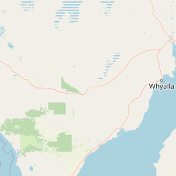
Map view of Dakalanta Sanctuary

Use this park location map to pinpoint Dakalanta Sanctuary in Australia, understand its exact geographic position, and read its mapped placement within the surrounding landscape more clearly.

Pigeon | © OpenStreetMap contributors

Location context for Dakalanta Sanctuary

South Australia
Park atlas

Discover other protected areas and mallee reserves across the Eyre Peninsula

Parks Near Dakalanta Sanctuary and Regional Protected Landscapes to Compare

Browse nearby national parks and connected conservation reserves sharing the semi-arid terrain of Dakalanta Sanctuary. Comparing surrounding protected landscapes provides broader geographic context for regional wildlife habitats.
Wildlife reserveSouth Australia
About 16 km away#1 closest

Northwest

Cocata Conservation Park: Eyre Peninsula Protected Wildlife Reserve and Landscape Map

Geographic overview of South Australian conservation lands.

Cocata Conservation Park encompasses a vast semi-arid expanse on the Eyre Peninsula, characterized by gently undulating plains, calcrete-capped terrain, and open salt flats. Gain insights into the physical geography and habitat distribution of this important South Australian wildlife reserve through detailed regional mapping.

Area
167.62 km²
Established
1993
IUCN
VI
Scope
Terrestrial
State or regional parkSouth Australia
About 61 km away#2 closest

Northeast

Corrobinnie Hill Conservation Park: Mapped Protected Landscapes and Geological Features

A remote conservation site on the Eyre Peninsula

Corrobinnie Hill Conservation Park protects an exceptional granite outcrop that stands as a natural monument within the South Australian landscape. The site is characterized by its weathered rock formations and its geographic connection to the broader Pinkawillinie conservation estate, offering insight into the geological diversity of remote Eyre Peninsula pastoral country.

Area
2.08 km²
Established
1983
IUCN
III
Relief
Upland
Nature reserveSouth Australia
About 62 km away#3 closest

South

Cap Island Conservation Park: Nature Reserve and Offshore Marine Habitat in South Australia

Coastal granite island and protected seabird breeding landscape.

Situated off the coast of the Eyre Peninsula, Cap Island Conservation Park is a protected nature reserve serving as a critical sanctuary for pinnipeds and nesting seabirds. Its unique geological profile, featuring a granite base and calcarenite cap, creates a rugged offshore environment shaped by marine erosion and salt-tolerant vegetation. The reserve highlights the significance of isolated island ecosystems within the broader geography of South Australia.

Area
0.09 km²
Established
1967
IUCN
Ia
Relief
Lowland
Wildlife reserveSouth Australia
About 64 km away#4 closest

Southeast

Hincks Conservation Park: Protected Wildlife Reserve in South Australia

Mapping regional biodiversity and conservation landscapes

Hincks Conservation Park functions as a key protected area within the semi-arid coastal hinterland of the Eyre Peninsula. This reserve preserves an essential fragment of native vegetation against a surrounding backdrop of agricultural development. The site highlights the importance of managed land corridors in maintaining ecological connectivity across the central-eastern reaches of South Australia.

Area
8.78 km²
Established
1941
IUCN
VI
Relief
Lowland
National parkSouth Australia
About 67 km away#5 closest

North

Gawler Ranges National Park: South Australia's Mapped Protected National Landscape

Explore the geography and protected area context of this national park.

Gawler Ranges National Park stands as a significant protected area within the geographic expanse of South Australia. Designated as a national park, it offers valuable insights into Australia's conservation landscapes and regional geography. Users can explore its mapped boundaries and understand its unique role within the national park system, making it a key point for structured geographic study and atlas-based discovery of protected lands.

Area
1,628.75 km²
Established
2002
IUCN
VI
Relief
Mountain
Wildlife reserveSouth Australia
About 78 km away#6 closest

East

Darke Range Conservation Park: A Protected Woodland Sanctuary in South Australia

Geographic landscape and regional habitat exploration

Located near Darke Peak, this wildlife reserve safeguards threatened native peppermint gum woodland. The park functions as an ecologically significant pocket of intact vegetation, providing a window into the natural ridge terrain of the Eyre Peninsula that remains distinct from the surrounding rural land.

Area
6.93 km²
Established
1985
IUCN
VI
Relief
Mountain
Nature reserveSouth Australia
About 81 km away#7 closest

East

Caralue Bluff Conservation Park: A Protected Nature Reserve on the Eyre Peninsula

Mapping regional landscape integrity in South Australia

Caralue Bluff Conservation Park encompasses a 21.5 square kilometre tract of land in South Australia, acting as a crucial element of the Eyre Peninsula landscape. Named for the nearby Caralue Bluff landform, this nature reserve safeguards essential bushland habitats within a highly developed rural setting. Analyze the park boundaries and terrain characteristics to better appreciate its function as a conserved natural refuge.

Area
21.57 km²
Established
1993
IUCN
VI
Scope
Terrestrial
Wildlife reserveSouth Australia
About 87 km away#8 closest

North

Gawler Ranges Conservation Park: Mallee Landscapes and Regional Protected Areas

Semi-arid habitat and rocky terrain of South Australia

Gawler Ranges Conservation Park protects a core area of tree mallee woodland and rocky rises near the southern fringe of the Gawler Ranges. This wildlife reserve serves as an essential anchor for regional biodiversity on the Eyre Peninsula, offering a look at the arid-adapted vegetation and weathered geological structures that define this remote section of South Australia.

Area
154.8 km²
Established
1993
IUCN
VI
Relief
Upland

Common questions about visiting, size, designation, and location context for Dakalanta Sanctuary

Dakalanta Sanctuary FAQs for park facts, access, geography, and protected area context

Find quick answers about Dakalanta Sanctuary, including protected-area facts, park geography, trail and visitor context, and how the park fits into its surrounding country and regional landscape.
MoriAtlas Explorer

Continue Your Protected Areas Search Across the Global Atlas

Deepen your exploration by continuing the structured search for national parks and protected areas worldwide. Utilize the comprehensive filtering capabilities to compare different conservation landscapes and refine your understanding of global park geography. Discover more about the distribution and characteristics of protected natural areas.

Global natural geography