

Mori Atlas logo
Marine protected areaDampier Marine Park

A critical multi-use marine reserve defining the tropical shelf habitats of Western Australia

Dampier Marine Park: Navigating the Marine Protected Area and Pilbara Shelf Geography

Dampier Marine Park encompasses 1,252 square kilometres of shallow continental shelf waters located offshore of the Pilbara coast. This marine protected area functions as a essential corridor for migratory humpback whales and serves as a primary foraging ground for seabirds and marine turtles. Within the broader Northwest Marine Parks Network, its structured zoning protects representative seafloor communities, habitats, and sediment structures of the Pilbara bioregion.

marine parkAustralian marine parksPilbaraNorthwest Shelftropical shelf habitatmarine turtles

Dampier Marine Park

Marine protected area

Park overview

Structured park overview, official facts, and landscape profile for Dampier Marine Park

Dampier Marine Park park facts, protected area profile, and essential visitor context

Review the core facts for Dampier Marine Park, including designation, size, terrain, visitor scale, habitats, and operating context in one park-focused overview.

About Dampier Marine Park

Dampier Marine Park is a federally designated marine protected area set in the tropical waters off the Pilbara coast of Western Australia. Situated north-east of the industrial and port city of Karratha, it lies just offshore from the Dampier Archipelago, a cluster of islands and coastal waters already protected under state arrangements and known for their rich marine biodiversity, Indigenous heritage, and long history of human use along the Pilbara shoreline.

The marine park occupies shallow continental shelf waters, typically ranging from around 15 metres to 70 metres in depth. This seabed is part of the broader Northwest Shelf Province, an Indo-Pacific marine system of global ecological and economic significance. The Pilbara nearshore and offshore waters host diverse fish, invertebrate, seabird, and marine mammal communities, and are also the backdrop to one of the world's largest industrial shipping and resources operations, including iron ore exports, LNG processing, salt production, and offshore oil and gas activity. The park's purpose is to ensure that representative examples of these Pilbara and shelf habitats are formally protected within an otherwise heavily used marine region.

The marine park was proclaimed under the Environment Protection and Biodiversity Conservation Act in December 2013, originally as the Dampier Commonwealth Marine Reserve, and was subsequently renamed Dampier Marine Park. After a transitional period involving planning and zoning revisions, the park's management plan and formal protection measures came into effect on 1 July 2018. It is now one of thirteen marine parks that together form the North-west Marine Parks Network, managed by Parks Australia on behalf of the Australian Government.

Although the park as a whole is assigned an overall IUCN category VI designation, meaning it permits a controlled mix of compatible uses, its interior is spatially organised into several zones. These zones include a fully protected National Park Zone, a Habitat Protection Zone, and a Multiple Use Zone, each with its own rules on activities such as fishing, tourism, aquaculture, and mining. This internald zoning arrangement makes the park a notable example of how conservation outcomes can be embedded within a working industrial maritime region, rather than being concentrated in a single fully restricted area.

Quick facts and research context for Dampier Marine Park

Dampier Marine Park sits in Commonwealth waters off the Pilbara coast of Western Australia, directly north-east of Karratha and adjacent to the Dampier Archipelago.

The park covers an area of about 1,252 square kilometres and protects shallow shelf habitat ranging roughly from 15 metres to 70 metres in depth. It forms part of the North-west Marine Parks Network, a network of thirteen marine parks that together represent one of Australia's largest federal systems of marine protection. It is managed by Parks Australia and its regulations and management plan came into effect on 1 July 2018.

Protection and recognition

Documented marine protection scope and official designation records

Dampier Marine Park Protection Status and Designation History

Dampier Marine Park maintains a documented marine protection status established in 2013 under official conservation guidelines. Structured records track the designation history and management scope associated with this protected area.

Protection details

Protection scope
Marine
Designated year
2013
Transboundary protection
No
Park context

Deeper park guide and search-rich context for Dampier Marine Park

Dampier Marine Park history, landscape, wildlife, and travel context

Explore Dampier Marine Park through its history, landscape character, ecosystems, wildlife, conservation priorities, cultural context, and seasonal travel timing in a structured park guide built for atlas discovery and search intent.

Why Dampier Marine Park stands out

Dampier Marine Park is best known for protecting migratory seabird foraging habitat, marine turtle nesting and feeding grounds, and the migratory pathway of humpback whales along the Northwestern Australian coast. Equally distinctive is its position over one of the most ecologically important shallow shelf provinces in the Indo-Pacific region. The park preserves representative examples of the seafloor communities, habitats, and depth ranges of the Northwest Shelf Province and the Pilbara nearshore and offshore meso-scale bioregions, areas that are otherwise exposed to intense industrial activity associated with the Pilbara's port and resources sector.

Dampier Marine Park history and protected-area timeline

Dampier Marine Park has a relatively short but formally defined administrative history. Its origins lie in the Australian Government's broader expansion of Commonwealth marine reserves during the early 2010s, alongside the establishment of networks of marine parks off the south-east, south-west, north, north-west, and temperate east coasts of Australia.

The reserve was proclaimed on 14 December 2013 under the Environment Protection and Biodiversity Conservation Act, becoming one of the marine protected areas that together would form the North-west Marine Parks Network. At the time of proclamation it was known as the Dampier Commonwealth Marine Reserve, reflecting the older naming convention for Commonwealth marine reserves.

As part of the transition toward a regenerated Australian marine parks system, the reserve was renamed Dampier Marine Park on 9 October 2017. A revised management plan and accompanying protection measures were developed and then came into effect on 1 July 2018, formally activating the park's zoning, regulations, and operational arrangements. The Department of Climate Change, Energy, the Environment and Water, through Parks Australia, now administers the park as part of the wider North-west network.

Dampier Marine Park landscape and geographic character

The landscape of Dampier Marine Park is entirely marine, defined by the shallow continental shelf waters of the northwestern Pilbara coast. Depths within the park generally range from around 15 metres to 70 metres, placing these waters at the upper end of the photic zone where light still reaches the seafloor and supports a broad variety of benthic habitats.

The seabed includes a mosaic of soft sediments, rubble, and hard reef structures that are characteristic of the Northwest Shelf Province. Although the park is wholly submerged, the surface waters above it are also visually distinctive: they are warm, tropical, and often turbid, influenced by strong tidal exchange and sediment plumes from the nearby Pilbara rivers and industrial coastal activity. On clear days, the scattered islands of the Dampier Archipelago rise just to the south, framing the seascape and providing context for the park's name.

The shallow shelf setting is important for both ecological and physical reasons. It concentrates nutrients, supports rich plankton communities, and creates productive feeding zones for migratory pelagic species. It also creates the conditions for a complex seafloor topography formed over millennia by ancient sea-level changes, sediment deposition, and reef development.

Dampier Marine Park ecosystems, habitats, and plant life

Ecologically, Dampier Marine Park represents the nearshore and offshore Pilbara waters and the broader tropical Northwest Shelf Province, one of the most productive marine regions in the Indo-Pacific. The park conserves examples of the seafloor habitats, communities, and depth zones typical of this province, rather than any one single habitat.

Coral, sponge, and other benthic invertebrate communities flourish across the shallow shelf, alongside sediment-dwelling fauna that characterise softer substrates. Fish communities in these waters include both resident reef and demersal species and seasonally present pelagic visitors. The whole of the Northwest Shelf region is known for its high marine productivity, driven by nutrient-rich tropical waters and upwelling, which in turn support wide-ranging predators such as sharks, rays, and large pelagic fishes.

The warm tropical climate and shallow bathymetry also help sustain seasonal blooms, plankton productivity, and the broader food webs on which seabirds, marine turtles, and cetaceans depend. Because the park protects an intact swath of these shelf waters, it effectively safeguards a representative sample of Pilbara marine ecosystems rather than a narrow slice.

Dampier Marine Park wildlife and species highlights

Wildlife is one of the park's defining conservation assets. The marine waters of Dampier Marine Park are recognised for their role in supporting migratory seabirds, particularly as foraging habitat adjacent to important breeding areas along the nearby coast and islands.

Marine turtles are another major focus, with park waters functioning as foraging grounds adjacent to significant nesting sites in the Dampier Archipelago and surrounding Pilbara coast. These sites are part of an internationally important regional network for flatback, green, hawksbill, and other tropical marine turtle species.

The park also sits on the migratory pathway of the humpback whale, the population that breeds in the warm tropical waters off northwestern Australia and feeds in the Southern Ocean. Whales travel past and through these shelf waters during their annual northern and southern migrations, making the park a section of an important migratory corridor. Pelagic fishes, sharks, rays, and a range of smaller reef and benthic species complement the broader wildlife picture, contributing to the park's role as a multi-species conservation area.

Dampier Marine Park conservation status and protection priorities

Dampier Marine Park plays a significant role in marine conservation for northwestern Australia. Its value lies in the protection of an intact block of shallow shelf habitat within the Pilbara, a region otherwise defined by some of the country's most intense port, shipping, and resources activity.

By safeguarding foraging areas adjacent to important seabird breeding colonies and marine turtle nesting sites, the park directly contributes to the persistence of locally and internationally recognised populations. By protecting a stretch of the migratory pathway of humpback whales through the Northwest Shelf, the park supports the conservation of a species that depends on these tropical waters during its annual cycle.

The park's zoning model is itself a conservation tool. Although the overall reserve carries an IUCN category VI designation, the inclusion of a fully protected National Park Zone within the broader park means that substantial areas of seafloor habitat are shielded from extractive use. The Habitat Protection and Multiple Use Zones allow regulated activities to continue where they are compatible with the park's conservation objectives, balancing ongoing economic activity in the Pilbara with the long-term protection of marine biodiversity. This combination of strict and multiple-use zones gives the park ecological and policy significance beyond its area alone.

Dampier Marine Park cultural meaning and human context

The waters of Dampier Marine Park are part of the Country of Aboriginal peoples of the Pilbara coast, whose continuous connection with this marine environment extends back thousands of years. Coastal and island groups in the Dampier Archipelago region have long-standing cultural, spiritual, and subsistence relationships with the sea, including traditional harvesting, navigation, and storytelling traditions tied to marine animals, seasons, and tidal cycles.

The early modern European history of the area is closely tied to the maritime exploration of Western Australia's northwest. The nearby Dampier Archipelago is named after the English explorer William Dampier, who visited the region in the late seventeenth century while engaged in privateering and exploration in the East Indies. Modern Karratha and the surrounding Pilbara towns grew around the pastoral, pearling, and later iron ore, salt, and natural gas industries, shaping both the demographic and industrial character of the coast that the marine park now borders.

These overlapping layers of Indigenous connection, exploration history, and industrial development together form the cultural backdrop against which the marine park has been established, and they continue to influence how the park is governed, used, and understood.

Top sights and standout views in Dampier Marine Park

Dampier Marine Park stands out for its combination of tropical shelf habitat protection, migratory species conservation, and multi-zone regulatory design within one of Australia's busiest industrial maritime regions.

The park's highlights include its foraging habitat value for migratory seabirds, its proximity to major marine turtle nesting areas, its position on the humpback whale migratory pathway, and its representation of the seafloor communities of the Northwest Shelf Province and the Pilbara nearshore and offshore bioregions. Its tiered zoning, combining a fully protected National Park Zone with Habitat Protection and Multiple Use zones, makes it a notable example of how federal marine parks integrate conservation with regulated use in a working coastal economy.

Best time to visit Dampier Marine Park

Seasonality in and around Dampier Marine Park is shaped primarily by tropical climate cycles rather than by access infrastructure, since the park is a marine zone rather than a land-based visitor destination in the traditional sense. The broader Pilbara region has a hot, dry tropical climate with a distinct wet season, generally running through the Australian summer and into early autumn, and a cooler, drier dry season through the rest of the year.

Wildlife viewing opportunities vary across the year. Humpback whales are most commonly observed along the Pilbara coast during their northward and southward migrations, broadly between late autumn and spring, with peak sightings varying from year to year. Marine turtle nesting at nearby beaches typically follows seasonal cycles associated with the warmer months, while seabird breeding and foraging activity is tied to local colony calendars on the Dampier Archipelago.

Because the park is offshore and primarily a conservation zone, any visit or viewing experience is largely dependent on vessel-based wildlife tours, dive operators, or coastal lookouts run from surrounding centres such as Karratha and Dampier. Travellers interested in calmer seas and cooler conditions generally find the dry season more comfortable for marine wildlife viewing, although tropical conditions outside this period can also offer rewarding wildlife encounters.
Monthly climate preview

Long term representative temperature and precipitation averages recorded across twelve monthly cycles

Dampier Marine Park Climate Normals and Annual Weather Patterns

Dampier Marine Park exhibits measured annual temperature variations and monthly precipitation rhythms across a representative coordinate point in Western Australia. Reviewing the complete twelve month climate normal profile provides detailed baseline data for researchers analyzing regional marine conservation environments.
Annual mean26 °C
22 °C30 °C
Jan29°
Feb29°
Mar30°
Apr29°
May26°
Jun23°
Jul22°
Aug22°
Sep24°
Oct26°
Nov27°
Dec28°
Warmest month
March

29.8 °C

Coolest month
July

21.7 °C

Wettest month
February

3.5 mm/day

Driest month
October

0 mm/day

Park location guide

Geography guide, regional context, and park location map for Dampier Marine Park

Dampier Marine Park park geography, regions, and map view in Australia

Understand where Dampier Marine Park sits in Australia through a broader geographic reading of the surrounding landscape, nearby location context, and its mapped position within the national park landscape.

How Dampier Marine Park fits into Australia

Australia is a constitutional monarchy and federal parliamentary democracy comprising six states and ten territories. With a population of nearly 28 million, it is one of the world's most urbanised countries, with most people concentrated on the eastern seaboard. The country has a high Human Development Index and is known for its cultural diversity, ancient Aboriginal heritage, and unique wildlife.

Wider geography shaping Dampier Marine Park in Australia

Australia occupies the entire Australian continent, the island of Tasmania, and numerous smaller islands. It is the world's flattest and driest inhabited continent, featuring vast deserts in the interior (the Outback), tropical rainforests along the eastern coast, and a coastline bordering the Indian and Pacific Oceans.

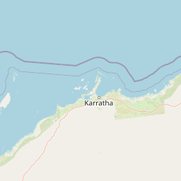
Map view of Dampier Marine Park

Use this park location map to pinpoint Dampier Marine Park in Australia, understand its exact geographic position, and read its mapped placement within the surrounding landscape more clearly.

Pigeon | © OpenStreetMap contributors

Location context for Dampier Marine Park

Western Australia
Recorded earthquake history

Examine the Historical Earthquake Records for Dampier Marine Park

Gain insight into the seismic history of the waters surrounding Dampier Marine Park. This catalogue provides recorded earthquake data, including magnitudes and epicentre proximity, to support a deeper geographic exploration of this important marine protected area using MoriAtlas data.

Dampier Marine Park Earthquake History

Catalogued events

2 events

Strongest magnitude

Magnitude 4.8

Most recent event

Feb 4, 2003

This history includes earthquakes recorded inside the park or within 50 km of its borders

Park atlas

Compare marine reserves and protected landscapes across the surrounding northwestern coast.

Explore Other Parks Near Dampier Marine Park and Regional Protected Areas

Browse related protected areas and coastal marine reserves situated along the same continental shelf ecosystems as Dampier Marine Park. Expanding the comparison across nearby waters reveals broader regional biodiversity patterns and connected conservation networks.
National parkPilbara
20 km away#1 closest

Southwest

Murujuga National Park: Pilbara Region's Protected Natural Landscape

Explore mapped park boundaries and regional geography.

Murujuga National Park represents a vital protected territory within the Pilbara region of Australia. This page provides focused atlas information on the park's geographic scope, mapped terrain, and its significance as a national park. Understand the unique landscape context of Murujuga National Park and its place within the broader regional geography, offering detailed insights for geographic exploration.

Area
48.51 km²
Established
2013
Climate
Arid
Access
Moderate access
National parkWestern Australia
68 km away#2 closest

South

Millstream Chichester National Park: A Mapped Protected Landscape in Western Australia

Explore its geographic spread and natural terrain features.

Millstream Chichester National Park is a designated national park within the vast geographic expanse of Western Australia. This entry provides detailed atlas-level information focused on its protected boundaries and distinct landscape characteristics. Understand the park's role within the regional geography and its significance as a mapped natural area for discovery and exploration.

Area
2,381.67 km²
Established
1970
IUCN
II
Relief
Mixed relief
Marine protected areaWestern Australia
121 km away#3 closest

West

Montebello Islands Marine Park: Western Australia Marine Protected Area Atlas

Mapping tropical reefs and archipelago terrain

Montebello Islands Marine Park preserves a significant archipelago and its surrounding tropical marine environment off the Pilbara coast. The area features extensive reef flats, mangrove communities, and deep oceanic waters that provide essential habitat for marine life and nesting sea turtles. Its physical profile includes a unique mix of natural reef-building processes and human history, making it a key component of the Western Australian marine conservation landscape.

Area
583.44 km²
Established
2004
IUCN
II
Relief
Lowland
National parkWestern Australia
189 km away#4 closest

Southeast

Karijini National Park: Explore the Protected Landscape and Geographic Context in Western Australia

Mapped natural terrain and regional geography for this Australian national park.

Karijini National Park is a designated national park in Western Australia, offering a distinct protected landscape for geographic exploration. This detailed entry provides context on its specific location within the state, its mapped boundaries, and the surrounding natural terrain. It serves as a foundational element for understanding the park's role within the larger atlas of protected areas and natural geography across Australia.

Area
6,274.22 km²
Established
1969
IUCN
II
Visitors
166K annual
Marine protected areaWestern Australia
282 km away#5 closest

North

Argo-Rowley Terrace Marine Park: Mapped Geography and Marine Protected Area Context

Expansive oceanic territory within the Western Australian region

Argo-Rowley Terrace Marine Park represents a vast offshore environment protecting diverse aquatic life and unique seafloor features. This marine protected area bridges the gap between the isolated Rowley Shoals and deep-water abyssal hills. The region is essential for understanding the structural geology of the ocean floor, encompassing everything from shallow reefs to abyssal plains in the remote north-west of Australia.

Area
146,003 km²
Established
2018
IUCN
VI
Relief
Lowland
Marine protected areaWestern Australia
310 km away#6 closest

Southwest

Ningaloo Marine Park: Mapping Western Australia's Protected Marine Geography and Habitats

Examining the oceanic shelf and reef environments of this key marine protected area

Ningaloo Marine Park safeguards a dynamic mosaic of shallow lagoons, reef edges, and deeper slope environments off the coast of Western Australia. This protected expanse is central to the regional conservation of whale shark feeding grounds and humpback whale migratory routes, offering a detailed perspective on the geomorphological character of the Central Western Shelf Transition.

Area
2,435 km²
Established
1987
IUCN
IV
Relief
Lowland
Marine protected areaWestern Australia
325 km away#7 closest

Southwest

Gascoyne Marine Park: Protected Marine Geography and Seafloor Terrain Map

Marine protected area situated along the Western Australian coast

Gascoyne Marine Park encompasses a significant offshore region defined by its shallow continental shelf and varied seafloor structures. This protected marine area supports vital habitats for migratory species and contributes to the broader ecological network of the North-west Marine Parks system, offering a clear view of specialized aquatic environments through detailed mapping.

Area
81,766 km²
Established
2018
IUCN
IV
Relief
Lowland
Watercolor illustration showing a coastal scene with shoreline, water, and landforms
National parkWestern Australia
341 km away#8 closest

Southwest

Cape Range National Park: Exploring Western Australia's Protected Landscape Identity

Mapped boundaries and regional geographic context.

Cape Range National Park is a vital protected area located in Western Australia, offering a distinct geographic profile for atlas exploration. This entry focuses on its identity as a national park, detailing its mapped landscape and regional context. Users can discover the park's place within the state's diverse terrain and understand its significance as a mapped conservation area, contributing to a structured understanding of Australia's protected lands.

Area
476.55 km²
Established
1965
IUCN
II
Relief
Highland

Common questions about visiting, size, designation, and location context for Dampier Marine Park

Dampier Marine Park FAQs for park facts, access, geography, and protected area context

Find quick answers about Dampier Marine Park, including protected-area facts, park geography, trail and visitor context, and how the park fits into its surrounding country and regional landscape.
MoriAtlas Explorer

Continue Your Protected Areas Search Across the Global Atlas

Deepen your exploration by continuing the structured search for national parks and protected areas worldwide. Utilize the comprehensive filtering capabilities to compare different conservation landscapes and refine your understanding of global park geography. Discover more about the distribution and characteristics of protected natural areas.

Global natural geography