Mori Atlas logo
National parkDay Forest National Park

Discover the unique geography and endemic species refuge of this critical East African forest ecosystem.

Day Forest National Park: Djibouti's Ancient Juniper Forest and Protected Landscape Atlas

(Forêt du Day National Park)

Day Forest National Park stands as Djibouti's oldest national park and its sole significant forest sanctuary, an ecological marvel in the arid Horn of Africa. Situated within the Goda Mountains of the Tadjourah Region, this protected area safeguards a rare East African juniper woodland, an isolated refuge crucial for endemic biodiversity. Explore the park's unique mountainous terrain, where approximately 5,900 hectares of vital forest survive due to localized precipitation, creating a stark, verdant contrast against the surrounding semi-desert landscape.

Juniper forestEndemic speciesMountain forestBirdwatchingProtected forestEast Africa

Day Forest National Park

National park

Park overview

Structured park overview, official facts, and landscape profile for Day Forest National Park

Day Forest National Park park facts, protected area profile, and essential visitor context

Review the core facts for Day Forest National Park, including designation, size, terrain, visitor scale, habitats, and operating context in one park-focused overview.

About Day Forest National Park

Day Forest National Park occupies a unique place in Djibouti's environmental heritage as the country's largest and oldest protected forest area. Located in the Goda Mountains within the Tadjourah Region, the park rises above the surrounding semi-desert terrain, creating a distinct ecological island that supports remarkable biodiversity. The park's establishment in 1939 reflected early recognition of the area's exceptional ecological value, and it remains the cornerstone of Djibouti's conservation estate. The forest ecosystem is characterized by its juniper-dominated canopy at higher elevations, where ancient trees form a dense woodland that would be impossible in the surrounding climate. The park's significance extends beyond its immediate boundaries as a watershed and biodiversity refuge in one of Africa's most environmentally vulnerable countries.

Quick facts and research context for Day Forest National Park

Day Forest National Park covers roughly 5,900 hectares in the Goda Mountains, with its most significant feature being a 900-hectare stand of East African junipers growing above 950 metres elevation. The park was established in 1939 and holds IUCN Category II protection status. It contains four dominant tree species: Juniperus procera, Olea europaea subsp. cuspidata, Buxus hildebrandtii, and Tarchonanthus camphoratus. The region receives about 500 millimetres of rainfall annually, making it the wettest part of Djibouti. The park lies near the town of Tadjoura and represents one of only two remaining closed-forest areas in the country.

Protection and recognition

Exploring terrestrial designation framework and verified international conservation records.

Day Forest National Park Protected Area Status and Designation Scope

Official terrestrial records detail the formal protection scope and establishment framework governing Day Forest National Park. Reviewing verified dataset metrics helps clarify regional conservation priorities and confirms the current absence of overlapping global treaty designations.

Protection details

Protection scope
Terrestrial
Transboundary protection
No
Park context

Deeper park guide and search-rich context for Day Forest National Park

Day Forest National Park history, landscape, wildlife, and travel context

Explore Day Forest National Park through its history, landscape character, ecosystems, wildlife, conservation priorities, cultural context, and seasonal travel timing in a structured park guide built for atlas discovery and search intent.

Why Day Forest National Park stands out

Day Forest is best known for its remarkable East African juniper forest, which is the largest and most significant juniper woodland in Djibouti. The park protects one of the last remaining closed-forest ecosystems in a country that is predominantly semi-desert, making it a critical ecological island in the Horn of Africa. It is also renowned for its population of endemic bird species, including the Djibouti spurfowl and a potentially distinct population of green-winged pytilia, both found only within this forest. The juniper trees can reach heights of 20 metres, creating a distinctive mountainous forest environment that contrasts sharply with the surrounding arid landscape.

Day Forest National Park history and protected-area timeline

Day Forest National Park was established in 1939, making it Djibouti's oldest national park and one of the earliest protected areas in the Horn of Africa. The creation of the park reflected colonial-era recognition of the forest's unique ecological character and its importance as a watershed for surrounding communities. Over the subsequent decades, the park has maintained its protected status through various political transitions, from French Somaliland to independent Djibouti. The park's boundary and management framework have provided continuous protection for the forest ecosystem, though conservation challenges have intensified over time as pressures on natural resources have grown across the region.

Day Forest National Park landscape and geographic character

The landscape of Day Forest National Park is defined by the Goda Mountains, a range that rises dramatically from the surrounding semi-desert lowlands. The park's terrain ranges from lower slopes dominated by mixed woodland to crest areas where the ancient juniper forest creates a distinctive mountainous forest environment. Elevation is a key driver of vegetation patterns, with the most valuable juniper stands occurring above 950 metres where moisture conditions support denser growth. The forest exists as an isolated patch of green amid extensive arid terrain, visible from considerable distances as a dark band across the mountain crest. The combination of mountain terrain, forest canopy, and the sharp contrast with surrounding savanna creates a landscape of significant visual and ecological distinction.

Day Forest National Park ecosystems, habitats, and plant life

The ecological character of Day Forest National Park is defined by its closed-forest ecosystem, which represents one of only two such areas remaining in Djibouti. The forest contains four dominant tree species: East African juniper (Juniperus procera), wild olive (Olea europaea subsp. cuspidata), boxwood (Buxus hildebrandtii), and Tarchonanthus camphoratus. The most significant ecological component is the juniper forest, which forms a 900-hectare stand at higher elevations. This juniper woodland represents a relict forest type with limited distribution in the Horn of Africa. The forest exists in a precarious ecological position, surviving in the wettest part of Djibouti where approximately 500 millimetres of annual precipitation provides the moisture necessary for closed-canopy forest development. The vegetation transitions from denser forest at higher elevations to more open woodland at lower slopes, with species composition shifting according to moisture availability and altitude.

Day Forest National Park wildlife and species highlights

Day Forest National Park supports a distinctive avian community with several species of notable conservation significance. The Djibouti spurfowl (Pternistis ochropectus) is a bird endemic to Djibouti that occurs within the park and represents one of the rarest Francolin species in Africa. A population of green-winged pytilia within the park may represent a distinct species or subspecies (Pytilia melba flavicaudata), further emphasizing the area's endemism. The mysterious Tôha sunbird, also known as the Djibouti sunbird, has only ever been recorded within Day Forest and remains undescribed scientifically. More widespread forest birds include the Gambaga flycatcher, Somali bulbul, and Somali starling. The park also provides habitat for the rare colubrid snake Platyceps afarensis. The combination of endemic and range-restricted species gives the park significant conservation value beyond its role as a forest refuge.

Day Forest National Park conservation status and protection priorities

Day Forest National Park faces severe conservation challenges despite its protected status. Approximately 88 percent of the original forest has been lost over the past two centuries, with more than 20 percent of that loss occurring within the last 50 years. This dramatic decline reflects the broader pattern of forest loss across Djibouti, where the combination of climate pressures, human activity, and limited regulatory capacity has accelerated environmental degradation. The juniper forest, once the dominant canopy type, has suffered significant mortality in recent decades, with many trees dying while boxwood has expanded in their place. The park remains the largest and most significant protected forest in Djibouti, but continued loss threatens its ecological viability. Conservation focus centers on protecting the remaining forest area, particularly the critical juniper stands above 950 metres elevation.

Day Forest National Park cultural meaning and human context

Day Forest exists within the cultural landscape of the Tadjourah Region, an area with traditional pastoralist and agricultural communities. The forest's existence as a wetter, more fertile area has historically provided resources and water catchments for local populations. The Goda Mountains hold cultural significance for surrounding communities, though the park's strict protection status now limits traditional land uses within its boundaries. The region around Tadjoura has historical connections to trade routes and Islamic culture that have shaped human settlement patterns across the Horn of Africa.

Top sights and standout views in Day Forest National Park

Day Forest National Park stands as Djibouti's ecological crown jewel, protecting the largest and most significant forest in a country that is otherwise overwhelmingly semi-desert. The ancient juniper forest at higher elevations represents a relict ecosystem with limited global distribution. The park's endemic bird species, including the Djibouti spurfowl and the mysterious Tôha sunbird, cannot be found anywhere else on Earth. The contrast between the forest's green canopy and the surrounding arid terrain creates one of the most visually striking landscapes in the Horn of Africa. The park provides critical watershed functions for the region and serves as a genetic reservoir for forest species adapted to this limited habitat.

Best time to visit Day Forest National Park

The optimal time to visit Day Forest National Park corresponds to the wet season, which typically runs from October through April when rainfall is most reliable and temperatures are moderate. The dry season from May to September brings hotter conditions and reduced water availability, though the forest retains its evergreen character year-round due to moisture retention in the higher elevations. Visitors interested in birdwatching may find the wet season most productive as resident species are more active and migratory movements occur. The cooler months from November to February offer the most comfortable conditions for hiking and exploration within the park.

Monthly climate preview

Monthly precipitation trends and temperature ranges for the protected Tadjourah Region landscape

Weather by Month and Average Temperature in Day Forest National Park

Long term records from 1991 to 2020 at the 605 meter representative elevation show average monthly temperatures ranging from 22.3 to 32.3 degrees Celsius. Exploring the complete monthly profile reveals detailed maximum and minimum trends alongside historical daily rainfall cycles for deeper geographic analysis.
Annual mean27 °C
22 °C32 °C
Jan22°
Feb23°
Mar25°
Apr27°
May30°
Jun32°
Jul31°
Aug30°
Sep30°
Oct27°
Nov24°
Dec23°
Warmest month
June

32.3 °C

Coolest month
January

22.3 °C

Wettest month
August

2.4 mm/day

Driest month
January

0.4 mm/day

Park location guide

Geography guide, regional context, and park location map for Day Forest National Park

Day Forest National Park park geography, regions, and map view in Djibouti

Understand where Day Forest National Park sits in Djibouti through a broader geographic reading of the surrounding landscape, nearby location context, and its mapped position within the national park landscape.

How Day Forest National Park fits into Djibouti

Djibouti is a small coastal country in the Horn of Africa, located along the Red Sea and Gulf of Aden. It gained independence from France in 1977 and serves as a key maritime hub and strategic military base location.

Wider geography shaping Day Forest National Park in Djibouti

Djibouti is situated in the Horn of Africa region of East Africa. It borders Somalia to the south, Ethiopia to the southwest, and Eritrea to the north, with coastline along the Red Sea and Gulf of Aden to the east. The terrain is mostly low-lying coastal desert, with some highlands in the southwest.

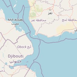
Map view of Day Forest National Park

Use this park location map to pinpoint Day Forest National Park in Djibouti, understand its exact geographic position, and read its mapped placement within the surrounding landscape more clearly.

Pigeon | © OpenStreetMap contributors

Location context for Day Forest National Park

Tadjourah Region
Park atlas

Map the surrounding protected landscapes, unique ecosystems, and regional park geography in the Horn of Africa.

Explore Other National Parks and Protected Areas Near Day Forest National Park in Djibouti

Expand your discovery from Day Forest National Park to browse other national parks and protected areas across Djibouti and the wider Horn of Africa region, comparing diverse landscapes. Trace the mapped geography of these conservation areas to understand their regional context, unique ecosystems, and important environmental roles.
National parkDjibouti
About 71 km away#1 closest

Southwest

Yoboki National Park: Djibouti National Park Geographic Atlas Explorer

Discover its mapped boundaries and regional terrain.

Yoboki National Park is a key protected area within Djibouti, offering a distinct focus for geographic exploration. This entry provides structured information to understand the park's mapped landscape and its position within the Horn of Africa's regional geography. Delve into the park's protected land identity and terrain context, essential for atlas-based discovery and appreciating its natural features.

IUCN
II
Relief
Mixed relief
Climate
Arid
Scope
Terrestrial
National parkAfar Region
About 189 km away#2 closest

Southwest

Yangudi Rassa National Park: Protected Semi-Desert National Park in Afar Region

Mapped landscape and dryland ecosystems.

Yangudi Rassa National Park represents a critical protected area within Ethiopia's Afar Region, covering extensive semi-desert and grassland terrains. The park's geography is marked by Mount Yangudi and the broad Rassa Plains, with the Awash River shaping its riverine forests and marshes. This national park offers a unique insight into dryland ecosystems and their conservation, providing a distinct mapped landscape for geographic study and exploration.

Area
4,731 km²
Established
1969
IUCN
II
Relief
Mixed relief
National parkSomalia
About 317 km away#3 closest

Southeast

Ga'an Libah National Park: A National Park's Protected Landscape and Geographic Context

Explore its mapped boundaries and regional geography.

Ga'an Libah National Park, designated as a national park, offers a distinct focus on its protected landscape and geographic identity. This resource details the mapped extent and regional context of the park, contributing to a structured understanding of its natural terrain and protected area significance. Users can explore its specific geography and atlas positioning without travel planning details.

National parkEthiopia
About 416 km away#4 closest

Southwest

Awash National Park: Mapped Protected Boundaries and Ethiopian Regional Geography

Discover the protected landscape of this Ethiopian National Park.

Awash National Park represents a significant protected area within Ethiopia, offering a rich focus for geographic discovery. This page illuminates the park's specific mapped boundaries and its positioning within the surrounding regional geography. It serves as a detailed entry point for understanding the park's landscape character and its role as a national park in East Africa.

Area
850 km²
Established
1966
IUCN
II
Relief
Mixed relief
National parkAmhara Region
About 482 km away#5 closest

West

Simien Mountains National Park: National Park Protected Landscape and Regional Geography

Explore Amhara Region's distinct mountain terrain and park boundaries.

Simien Mountains National Park serves as a key protected landscape within the Amhara Region of Ethiopia. This national park offers a distinct geographic identity, characterized by its unique terrain and mapped natural boundaries. Understanding this park provides valuable context for regional geography and the broader atlas of protected areas in northern Ethiopia.

Area
412 km²
Established
1969
IUCN
II
Visitors
26K annual
National parkEritrea
About 509 km away#6 closest

Northwest

Dahlak Marine National Park: Eritrea National Park Mapping and Protected Marine Landscape

Explore its Red Sea geography, coral ecosystems, and marine wildlife.

Delve into Dahlak Marine National Park, a premier protected marine area located off the coast of Eritrea. This national park preserves extensive coral reef formations, critical seabird nesting islands, and important mangrove zones within the Red Sea. It is renowned for supporting over 325 species of fish, providing sanctuary for nesting sea turtles, and being one of the few Red Sea locations where dugongs are found. The park's unique geography and marine biodiversity offer a compelling atlas-style exploration of protected landscapes in the Horn of Africa.

IUCN
II
Relief
Lowland
Access
Highly restricted
Scope
Marine
National parkArsi Zone
About 573 km away#7 closest

Southwest

Arsi Mountains National Park: Protected Ethiopian Highlands Landscape & Geography

Mapped protected terrain and endemic species habitat within the Arsi Zone.

Arsi Mountains National Park is a vast protected area celebrated for its significant biodiversity and distinctive Afro-alpine ecosystems. Situated in the Arsi Zone, this national park encompasses a dramatic mountain landscape central to the Ethiopian Highlands. It serves as a crucial refuge for endangered endemic species, including the mountain nyala and Ethiopian wolf, within its varied ecological zones and protected park boundaries, offering rich context for geographic exploration.

Area
10,876 km²
Established
2011
IUCN
II
Relief
Mountain
National parkEritrea
About 593 km away#8 closest

Northwest

Semenawi Bahri National Park: Eritrea's Highland Mountainous Protected Area

Explore the dramatic terrain and wildlife of Eritrea's highland national park.

Semenawi Bahri National Park represents a crucial protected landscape in Eritrea, characterized by its striking mountainous terrain. The park's elevation, ranging from 900 to 2400 meters, creates a distinctive highland environment with massive peaks and deep valleys. This unique geography supports a surprising diversity of wildlife, including species adapted to highland conditions, and makes it a compelling destination for exploring Eritrea's natural heritage through its mapped boundaries and regional context.

IUCN
II
Relief
Mountain
Access
Moderate access
Scope
Terrestrial

Common questions about visiting, size, designation, and location context for Day Forest National Park

Day Forest National Park FAQs for park facts, access, geography, and protected area context

Find quick answers about Day Forest National Park, including protected-area facts, park geography, trail and visitor context, and how the park fits into its surrounding country and regional landscape.
MoriAtlas Explorer

Continue Your Protected Areas Search Across the Global Atlas

Deepen your exploration by continuing the structured search for national parks and protected areas worldwide. Utilize the comprehensive filtering capabilities to compare different conservation landscapes and refine your understanding of global park geography. Discover more about the distribution and characteristics of protected natural areas.

Global natural geography